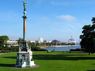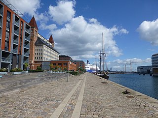
Indre Østerbro, was one of the administrative, statistical, and tax city districts ("bydele") comprising the municipality of Copenhagen, Denmark. It lay on the eastern edge of the municipality. It covered an area of 6.76 km2, had a population of 46,095 and a population density of 6,817 per km2. Since 2007, the district has been part of the administrative district Østerbro.

Langelinie is a pier, promenade and park in central Copenhagen, Denmark, and home of The Little Mermaid statue. The area has for centuries been a popular destination for excursions and strolls in Copenhagen. Most cruise ships arriving in Copenhagen also berth at Langelinie Pier.
Districts of Copenhagen are often based on informal designations based on historic origins, often with alternative names and loosely defined boundaries. Copenhagen Municipality is divided into 10 official administrative districts but they often comprise areas of a heterogeneous character which are informally not seen as one district. Some districts have earlier been official subdivisions and thus have semi-official boundaries. Copenhagen postal code designations often correspond to district boundaries but in some cases differ from them, as an example parts of the city centre has the postal code København V which is generally associated with Vesterbro.

Esplanaden is a street in Copenhagen, Denmark. It extends eastwards from Store Kongensgade and runs along the south side of the city's 17th-century fortress Kastellet and Churchillparken until it reaches the waterfront at Nordre Toldbod, just south of Langelinie, passing Amaliegade, Bredgade and Grønningen on the way. It marks the northern border of the Frederiksstaden district.

Churchillparken is a public park in Copenhagen, Denmark, occupying a tract of land between Kastellet, a 17th-century fortress, and the street Esplanaden. Located on the former esplanade which used to surround Kastellet, the area has a long history as a greenspace but received its current name in 1965 to commemorate Winston Churchill and the British assistance in the liberation of Denmark during World War II.

Vester Voldgade is a street in Copenhagen, Denmark which runs from Jarmers Plads to the waterfront between Frederiksholms Kanal and Langebro, passing the City Hall Square on the way.

Dahlerups Pakhus, originally known as Pakhus 1, is a former Warehouse situated on the west side of the Langelinie Pier, opposite the Middle Pier, in Copenhagen, Denmark. Designed by Vilhelm Dahlerup, from whom it now takes its name, it was built between 1892 and 1893.

Larsens Plads is a waterfront in Copenhagen, Denmark, which runs along the Zealand side of the Inner Harbour from the Nyhavn canal in the south to the Nordre Toldbod area just south of Langelinie to the north. The name refers to a shipyard which used to occupy the grounds but is now more associated with emigration to America after it became a major hub for trans-Atlantic traffic later in the century. Today, the area is dominated by Amalienborg Palace with the Amalie Garden and a number of late 18th-century warehouses which have been converted to other uses. The buildings facing the waterfront have their address on the parallel street Toldbodgade.

Amerika Plads is a public square and surrounding neighbourhood in the Østerbro district of Copenhagen, Denmark. It is the result of a redevelopment of an area in the southern part of the former Freeport of Copenhagen into a mixed-use neighbourhood which consists of dwellings, offices and retail establishments, combining converted historic buildings and modern architecture. The former Free Port Station building was put in storage during the redevelopment and is now located in the middle of the square where it serves as a café. The area is to the west bounded by Kalkbrænderihavnsgade, part of a major thoroughfare, and to the east by Dampfærgevej connected to Kalkbrænderihavnsgade in both ends and separating Amerika Plads from America Quay, the western quay of the Southern Free Port dock. The name of the area, like that of the quay, is a reference to the Amerikabåten, large passenger ships which used to transport Danish emigrants to New York City during the first half of the 20th century.

Toldbodgade is a street in central Copenhagen, Denmark. It extends north from Nyhavn at the Nyhavn Bridge, continuing Holberggade, passes Sankt Annæ Plads after just one block, and continues straight until it reaches West India Warehouse where it makes a sharp left turn which connects it to Amaliegade, its parallel street, at the rear of the Design Museum.

Nordre Toldbod is a waterfront area in Copenhagen, Denmark, located at the north end of Larsens Plads and just south of Kastellet. It takes its name after the custom house or toldbod which used to be located in the area. Most of the historic buildings in the area were torn down in 1973 when the site was redeveloped but its central waterfront space has remained intact and features a number of structures which bear testament to its former use. Among the modern buildings in the area are the headquarters of Mærsk and the Danish Energy Agency. The area is adjacent to Churchill and Langelinie Parks.

By & Havn or Udviklingsselskabet By & Havn I/S is an organisation, tasked with the development of Ørestad and the port of Copenhagen and the daily operations of the latter, which is done through a subsidiary, Copenhagen Malmö Port. By & Havn is owned by Copenhagen Municipality (55%) and the Danish government, through its ministry of transport (45%). Key areas of the organisation are Ørestad, Nordhavnen, Amerika Plads, Sluseholmen and Teglholmen. Currently the CEO is Anne Skovbro, while Pia Gjellerup serves as director of the board.

Indiakaj is a quay and adjacent street which marks the southern boundary of the Søndre Frihavn area of Copenhagen, Denmark. It originates in the west at Kalkbrænderihavnsvej and continue east to a roundabout at the base of Langelinie PPierer.

Midtermolen is a pier which extends north from India Quay in the Southern Free Port of Copenhagen, Denmark, dividing the dock into an east and west basin.

Amerikakaj is a 700 metre long quay along the west side of the Søndre Frihavn dock in Copenhagen, Denmark. The name commemorates the transatlantic passenger ships of the Scandinavian America Line which used to berth along the quay during the first half of the 20th century. Today DFDS's ferries to Oslo berth at its north end.
Marmormolen is a wharf in the Søndre Frihavn area of Copenhagen, Denmark. Currently under redevelopment, a new office building for the United Nations activities in Copenhagen is being built at its tip. The plans also include a highrise which will be connected to another highrise at the tip of Langelinie Pier across the entrance to the Søndre Frihavn dock by a pedestrian and cycling bridge 65 meters above the harbor.

Andreas Bjørn was a Danish merchant, shipbuilder and ship owner.

Østbanegade is a street in Copenhagen, Denmark. It begins at Østerport Station on Oslo Plads and continues north along the west side of the railway tracks for about 2 kilometres to Aarhusgade where an underpass connects the street to the other side of the railway line. A second underpass is situated at Nordre Frihavnsgade, just south of Nordhavn station, while a foot and cycle bridge is found at Mandalsgade near the beginning of the street.

The Langelinie Pavilion is a venue located at the Langelinie waterfront in Copenhagen, Denmark. The first Langelinie Pavilion was built in the 1880s but the current building is a Modernist structure from 1958 and was designed by Nils and Eva Koppel. It was listed on the Danish registry of protected buildings and places by the Danish Heritage Agency on 12 March 2006. Poul Henningsen's PH Artichoke lamp was designed for the building.

Gefion and Gylfe, situated at Østbanegade 19–21, between Stavangergade and Fridtjof Nansens Plads, is a pair of National Romantic high-end apartment buildings attached to each other by an archway across Mandalsgade in the Østerbro district of Copenhagen, Denmark. The symmetrical building complex was originally located in the axis of the Langelinie Bridge, an Asger Ostenfeld-designed steel bridge spanning the railway tracks just north of Østerport station, now replaced by a bicycle and footbridge. The two buildings were individually listed in the Danish registry of protected buildings and places in 2000. The Irish embassy is based in Gylfe. In Norse mythology, Gefion is the goddess who plouged Zealand out of Sweden. Gylfe is the king who challenged her to do so.


