Old Norse name | Kolbeinsey |
---|---|
Meaning of name | "Kobeinn's Island" |
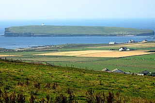
Southwards from the eastern edge of the Horse of Copinsay. Copinsay lighthouse is on the high ground in the distance. | |
Location | |
OS grid reference | HY607015 |
Coordinates | 58°54′N2°40′W / 58.9°N 2.67°W |
Physical geography | |
Island group | Orkney |
Area | 73 hectares (0.28 sq mi) |
Area rank | 170 [1] |
Highest elevation | 64 metres (210 ft) |
Administration | |
Council area | Orkney Islands |
Country | Scotland |
Sovereign state | United Kingdom |
Demographics | |
Population | 0 |
References | [2] [3] [4] [5] [6] |
Copinsay Lighthouse | |
Coordinates | 58°53′47″N2°40′19″W / 58.896432°N 2.672027°W |
Constructed | 1915 |
Built by | David Alan Stevenson |
Construction | stone tower |
Automated | 1991 |
Height | 16 metres (52 ft) |
Shape | cylindrical tower with balcony and lantern |
Markings | white tower, black lantern, ochre trim |
Power source | solar power |
Operator | Royal Society for the Protection of Birds [7] [8] |
Heritage | category B listed building |
Focal height | 39 metres (128 ft) |
Range | 21 nautical miles (39 km; 24 mi) |
Characteristic | Fl(5) W 30s |
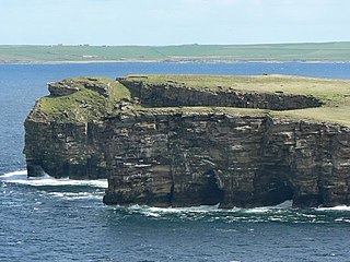
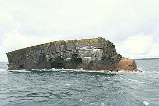
Copinsay (Old Norse : Kolbeinsey) is one of the Orkney Islands in Scotland, lying off the east coast of the Orkney Mainland. The smaller companion island to Copinsay, Horse of Copinsay lies to the northeast. The Horse is uninhabited, and is managed as a bird reserve. Copinsay is also home to a lighthouse.
Myths about the island include the story of the Copinsay Brownie. [9]
For many generations, prior to the final inhabitants moving to the Mainland in 1958, Copinsay was full of life. This is evidenced by the large double story farmhouse, the Steading (or farm buildings) behind it for the farm tenants, a school with a schoolteacher, and up to three lighthouse keepers' families.
There is also an ancient burial site on the island.
In the earlier part of the 20th century, a weekly postal service provided contact with the Mainland, and there were fortnightly shopping trips to Deerness, allowing for weather. The farm had working horses, cattle and sheep - all of which had to be transported on the "coo" or "cow" boat. Bird's eggs provided a good supplement to the islanders' diet, and men were lowered over the cliffs on a special rope, or were rowed out to the Horse to bring back this addition.
Pigs were loosed in the Spring on the Horse for many years, and they fed on the bird's eggs.
Many interesting facts and accounts of life on Copinsay are still retold in the Deerness Community, with many members still remembering when the island was still home to loved ones.
The island was bought by the ornithology charity RSPB in 1972 in memory of the naturalist James Fisher. [10] Although Copinsay today is uninhabited, some fields are still farmed at the behest of the RSPB, to try provide suitable conditions for Corncrake. As a result, a patchwork of yesteryear is returning to the island, even though the people have not. Together with the three adjacent three islets (Corn Holm, Ward Holm and Black Holm), it is designated a Special Protection Area (SPA) under the European Union directive on the Conservation of Wild Birds due to the unimproved grassland vegetation and sheer sandstone cliffs providing ideal breeding ledges for seabirds. [11] There is a large colony of grey seals on the island. They usually pup in November each year. Puffins can be seen during July on the adjacent holms.
Edwin Muir, a famous poet
Orkney, also known as the Orkney Islands or, the often deprecated, Orkneys, is an archipelago off the north coast of Scotland. Part of the Northern Isles along with Shetland, Orkney is 10 miles (16 km) north of Caithness and has about 70 islands, of which 20 are inhabited. The largest island, the Mainland, has an area of 523 square kilometres (202 sq mi), making it the sixth-largest Scottish island and the tenth-largest island in the British Isles. Orkney's largest settlement, and also its administrative centre, is Kirkwall.
Hoy is an island in Orkney, Scotland, measuring 143 square kilometres (55 sq mi) – the second largest in the archipelago, after Mainland. A natural causeway, the Ayre, links the island to the smaller South Walls; the two islands are treated as one entity by the UK census. Hoy is also the name of a hamlet in the northwest of the island.
The Brough of Birsay is an uninhabited tidal island off the north-west coast of The Mainland of Orkney, Scotland, in the parish of Birsay. It is located around 13 miles north of Stromness and features the remains of Pictish and Norse settlements as well as a modern lighthouse.
The Mainland, also known as Hrossey and Pomona, is the main island of Orkney, Scotland. Both of Orkney's burghs, Kirkwall and Stromness, lie on the island, which is also the heart of Orkney's ferry and air connections.
Stronsay is an island in Orkney, Scotland. It is known as Orkney's 'Island of Bays', owing to an irregular shape with miles of coastline, with three large bays separated by two isthmuses: St Catherine's Bay to the west, the Bay of Holland to the south and Mill Bay to the east. Stronsay is 3,275 hectares in area, and 44 metres in altitude at its highest point. It has a usually resident population of 349. The main village is Whitehall, home to a heritage centre.
Eday is one of the islands of Orkney, which are located to the north of the Scottish mainland. One of the North Isles, Eday is about 24 kilometres from the Orkney Mainland. With an area of 27 km2 (10 sq mi), it is the ninth-largest island of the archipelago. The bedrock of the island is Old Red Sandstone, which is exposed along the sea-cliffs.
North Ronaldsay is the northernmost island in the Orkney archipelago of Scotland. With an area of 690 hectares (2.7 sq mi), it is the fourteenth-largest. It is mentioned in the Orkneyinga saga; in modern times it is known for its historic lighthouse, migratory bird life and unusual breed of sheep.
Lamb Holm is a small uninhabited island in Orkney, Scotland. The Italian Chapel, constructed during the Second World War, is the island's main attraction.
The Calf of Eday is an uninhabited island in Orkney, Scotland, lying north east of Eday. It is known for its wildlife and its prehistoric ruins.
Graemsay is an island in the western approaches to Scapa Flow, in the Orkney Islands of Scotland. The island has two lighthouses. Graemsay lies within the parish of Stromness.
Swona is an uninhabited privately owned island in the Pentland Firth off the north coast of Scotland. It has a herd of feral cattle resulting from the abandonment of stock in 1974.
Dunnet Head is a headland in Highland, on the north coast of Scotland. Dunnet Head includes the most northerly point of both mainland Scotland and the island of Great Britain.
Fidra is a currently uninhabited island in the Firth of Forth, 4 kilometres northwest of North Berwick, on the east coast of Scotland. The island is an RSPB Scotland nature reserve.
Sule Skerry is a remote skerry in the North Atlantic off the north coast of Scotland.
Sumburgh Head is a headland located at the southern tip of the main island of the Shetland Archipelago, in northern Scotland. The head consists of a 100 m high rocky spur and topped by the Sumburgh Head Lighthouse. In the Old Norse language, Sumburgh Head was called Dunrøstar høfdi, it means "The Head onto the loud tide-race", referring to the noise of Sumburgh Roost. Robert Stevenson was the engineer in charge of building the Sumburgh Head lighthouse. Work started on the building in 1819, and the light was first lit in 1821.
Helliar Holm is an uninhabited island off the coast of Shapinsay in the Orkney Islands, Scotland. It is home to a 42-foot-tall (13 m) lighthouse, which was built in 1893 and automated in 1967. It is a tidal island that used to be connected to Shapinsay. It is still possible to walk across from the mainland during very low tides.
The Horse of Copinsay, also known as the Horse, is a rectangular uninhabited sea stack to the north east of Copinsay in the Orkney Islands, Scotland.
Yell Sound is the Sound running between Yell and Mainland, Shetland, Scotland. It is the boundary between the Mainland and the North Isles and it contains many small islands. Sullom Voe, on the shores of which is a substantial oil terminal, is an arm of Yell Sound.