
Back Bay is an officially recognized neighborhood of Boston, Massachusetts, built on reclaimed land in the Charles River basin. Construction began in 1859, as the demand for luxury housing exceeded the availability in the city at the time, and the area was fully built by around 1900. It is most famous for its rows of Victorian brownstone homes—considered one of the best preserved examples of 19th-century urban design in the United States—as well as numerous architecturally significant individual buildings, and cultural institutions such as the Boston Public Library, and Boston Architectural College. Initially conceived as a residential-only area, commercial buildings were permitted from around 1890, and Back Bay now features many office buildings, including the John Hancock Tower, Boston's tallest skyscraper. It is also considered a fashionable shopping destination and home to several major hotels.
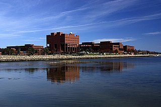
Dorchester is a neighborhood comprising more than 6 square miles (16 km2) in the City of Boston, Massachusetts, United States. Originally, Dorchester was a separate town, founded by Puritans who emigrated in 1630 from Dorchester, Dorset, England, to the Massachusetts Bay Colony. This dissolved municipality, Boston's largest neighborhood by far, is often divided by city planners in order to create two planning areas roughly equivalent in size and population to other Boston neighborhoods.

The Boston National Historical Park is an association of sites that showcase Boston's role in the American Revolution and other parts of history. It was designated a national park on October 1, 1974. Seven of the eight sites are connected by the Freedom Trail, a walking tour of downtown Boston. All eight properties are National Historic Landmarks.

The Parish of All Saints, Ashmont, is a church of the Episcopal Diocese of Massachusetts located at 209 Ashmont Street in the Dorchester neighborhood of Boston, Massachusetts. Built 1892-1929 for a congregation founded in 1867, it was the first major commission of architect Ralph Adams Cram, a major influence in the development of early 20th-century Gothic church and secular architecture. The church was listed on the National Register of Historic Places in 1980, and is protected by a preservation easement held by Historic New England.

The Boston Sanatorium is a historic tuberculosis hospital in the Mattapan neighborhood of Boston, Massachusetts. It consists of a complex of eighteen historic buildings on 52 acres (21 ha) of land. Most of these buildings were built between 1908 and 1932, although the Superintendent's House predates the hospital's construction; it is an Italianate house built c. 1856. They are predominantly brick buildings that are Colonial Revival in character, although the 1929 main administration building has a variety of different revival elements. Several of the buildings on the campus—The Administrative or Foley Building; The Doctor's Residences, Dormitories and Wards; and The Power House—were designed by the renowned architectural firm Maginnis and Walsh. The complex was the largest tuberculosis hospital in the state, built in response to reports that the disease was responsible for more deaths than any other in the city. The facility was used for the treatment of tuberculosis through the middle of the 20th century, and then stood largely vacant until 2002, when plans were laid to rehabilitate the property for other uses.
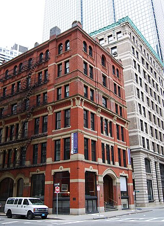
The Codman Building is a historic building at 55 Kilby Street in Boston, Massachusetts. The first four stories of this six-story brick and stone building were designed by Sturgis & Brigham and built in 1874 in the Gothic Revival style. It is the only one of the firm's commercial designs in the Financial District to survive. The upper three floors, in a more typical Late Victorian fashion, were added sometime before 1898.
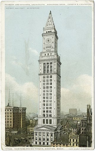
Custom House District is a historic district in Boston, Massachusetts, located between the Fitzgerald Expressway and Kilby Street and South Market and High and Batterymarch Streets. Named after the 1849 Boston Custom House located on State Street, the historic district contains about seventy buildings on nearly sixteen acres in Downtown Boston, consisting of 19th-century mercantile buildings along with many early 20th-century skyscrapers, including the 1915 Custom House Tower.

Clam Point is a sub-neighborhood in Boston, Massachusetts, USA, noteworthy for its collection of substantial Italianate Mansard residences. The area is known to have the most cohesive, intact collection of mansion-scale mid 19th-century housing in Boston, and includes the Park, Everett, Freeport, Mill, Ashland, Blanche Streets, and Victory Road in the Dorchester neighborhood of Boston. In the past decade, the historic area has attracted a new wave of development due to its location on a prime strip of waterfront overlooking Dorchester Bay and its proximity to the Red Line.

The Peabody is a historic apartment building at 195-197 Ashmont Street in the Dorchester neighborhood of Boston, Massachusetts. The 3+1⁄2-story Tudor Revival brick building was designed by Edwin J. Lewis Jr., a local architect, and built in 1896–97. It is named for its original owners Oliver and Mary Lothrop Peabody, who were, significant proponents of the development of the area. It was built as a complement to the nearby All Saints' Church, which also stands facing Peabody Square, and was financially supported by the Olivers.

The Upham's Corner Market is an historic commercial building at 600 Columbia Road in the Dorchester neighborhood of Boston, Massachusetts. It is actually three separate buildings built c. 1919, 1923, and 1926. They were built by brothers John and Paul Cifrino, who were Italian immigrants. They established a small neighborhood grocery store in 1915, before building this series of buildings to house what became an early supermarket. After the third section was built, the store had 50,000 square feet (4,600 m2) of space, and was the largest store of its kind in the city, serving a nearby population of more than 250,000. The buildings have been converted to mixed commercial and residential use.
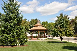
The Central Square Historic District is a historic district encompassing much of the central business district of Stoneham, Massachusetts. It includes the town's largest concentration of 19th and early-20th century commercial architecture, in an area that developed in importance as a commercial center after the construction of the Andover-Medford Turnpike. The district was added to the National Register of Historic Places in 1990.
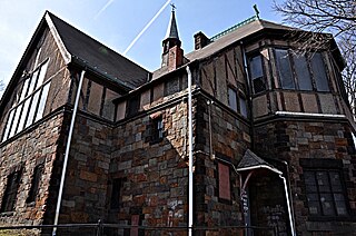
St. Mary's Episcopal Church is a parish of the Episcopal Church, noted for its historic church at 14–16 Cushing Avenue in the Dorchester neighborhood of Boston, Massachusetts. Founded in 1847, it remains an active congregation of the Episcopal Diocese of Massachusetts.

Hartwell and Richardson was a Boston, Massachusetts architectural firm established in 1881, by Henry Walker Hartwell (1833–1919) and William Cummings Richardson (1854–1935). The firm contributed significantly to the current building stock and architecture of the greater Boston area. Many of its buildings are listed on the National Register of Historic Places.
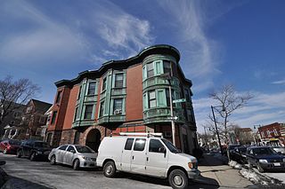
The Sarah Davidson Apartment Block is a historic commercial and multifamily residential building at 3 Gaylord Street in the Dorchester neighborhood of Boston, Massachusetts. The three-story brick, sandstone and copper Classical Revival building was constructed in 1901 to a design by A. B. Pinkham. The building, located at the corner of Gaylord and Washington Streets, has three commercial storefronts facing Washington Street, which are separated by sandstone piers. The residential entrance lies on Gaylord Street recessed in a rounded sandstone archway. The exterior of the upper floors consists of protruding sections finished in pressed copper, including a rounded corner section, and sections of brick. A heavy denticulated copper cornice overhangs both street-facing facades.
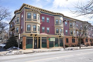
Walton and Roslin Halls is a mixed-used commercial and residential building that was built in two parts. They are located at the corner of Washington and Walton Streets in the Dorchester neighborhood of Boston, Massachusetts, and extend south along Washington Street. The first of the two buildings, that at 3-5 Walton Street and 702-708 Washington, is a three-story brick and wood-frame structure built in 1897 to a design by Cornelius A. Russell; the southern portion was completed a year later. The building housed a commercial space on the ground floor, and residential units above.

Fort Hill is a 0.4 square mile neighborhood and historic district of Roxbury, in Boston, Massachusetts. The approximate boundaries of Fort Hill are Malcolm X Boulevard on the north, Washington Street on the southeast, and Columbus Avenue on the southwest.
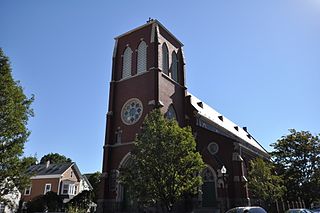
The Governor Shirley Square Historic District encompasses a cluster of civic, residential, and religious buildings at the junction of Dudley, Hampden, and Dunmore Streets in the Roxbury neighborhood of Boston, Massachusetts. Named for colonial governor William Shirley in 1913, the square was developed in the 1870s and 1880s as a major locus of civic development after the city of Roxbury was annexed to Boston in 1868. The district was listed on the National Register of Historic Places in 2016.

Second Church of Dorchester is a Church of the Nazarene in the historic Codman Square District of Dorchester in Boston, Massachusetts. In 1804 the church was founded as the Dorchester Meeting House Company by members from the First Parish Church of Dorchester.
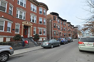
The Thane Street Historic District is a historic district encompassing a group of apartment houses in the Dorchester neighborhood of Boston, Massachusetts. Extending along Thane Street from Harvard Street, the area was developed in 1910, during a major Jewish migration, and includes a fine sample of Colonial Revival architecture. The district was listed on the National Register of Historic Places in 2020.
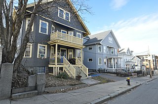
The Greenville Street Historic District is a historic district encompassing a primarily residential property in the Roxbury neighborhood of Boston, Massachusetts. Extending along Greenville Street, the district includes a diversity of architecture, and is prominent for significant urban renewal efforts conducted in the city in the 1960s and 1970s. The district was added to the National Register of Historic Places in 2021.


