Clifton is a census-designated place (CDP) and post office in and governed by Mesa County, Colorado, United States. It is part of the Grand Junction, CO Metropolitan Statistical Area. The Clifton post office has the ZIP Code 81520. As of the 2020 census, the population of the Clifton CDP was 20,413.

Ives Estates is a census-designated place (CDP) in Miami-Dade County, Florida. It is part of the Miami metropolitan area of South Florida. The population was 25,005 at the 2020 census, up from 19,525 in 2010.

Gresham Park is an unincorporated community and census-designated place (CDP) in DeKalb County, Georgia, United States. The population was 7,700 at the 2020 census.

Clifton Park is a suburban town in Saratoga County, New York, United States. According to the United States Census Bureau, the 2020 population was 38,029. The name is derived from an early land patent. The town is in the southern part of Saratoga County, approximately 12 miles (19 km) north of Albany, 7 miles (11 km) northeast of Schenectady, and 10 miles (16 km) south of Saratoga Springs.

Lincolnia is a census-designated place (CDP) in Fairfax County, Virginia, United States. The population was 22,828 at the 2010 census, an increase of over 44% from 2000.
Stone Ridge is a census-designated place in Loudoun County, Virginia, United States. Residences use Aldie mailing addresses, and it is near Washington Dulles International Airport. The population as of the 2020 census was 15,039. Stone Ridge is a Van Metre Homes planned, mixed-use community.
Fivepointville is an unincorporated community and census-designated place (CDP) in Brecknock Township, Lancaster County, Pennsylvania, United States. As of the 2010 census, the population was 1,156. The town is named for its position at an intersection of five separate roads.

Ravensworth is a census-designated place in Fairfax County, Virginia, United States. Its name reflects Ravensworth plantation, farmed since the 18th century and manor house which burned under mysterious circumstances on August 1, 1926. The Ravensworth Farm subdivision was developed in the early 1960s. The 2010 census lists the area's population as 2,466. It is part of the Washington metropolitan area.

Kings Park is a census-designated place (CDP) in the eastern United States in Fairfax County, Virginia, southwest of Washington D.C. The population as of the 2010 census was 4,333.

South Run is a census-designated place in Fairfax County, Virginia, United States. The population as of the 2010 census was 6,389.
Lake Luzerne is the primary hamlet and a census-designated place (CDP) within the town of Lake Luzerne, Warren County, New York, United States. As of the 2010 census, the population was 1,227, out of 3,347 residents in the entire town of Lake Luzerne. Before that, the community was part of the Lake Luzerne-Hadley census-designated place.
Hadley is the primary hamlet and a census-designated place (CDP) within the town of Hadley, Saratoga County, New York, United States. As of the 2010 census, the population was 1,009, out of 1,971 residents in the entire town of Hadley. Before that, the community was part of the Lake Luzerne-Hadley census-designated place.
Absecon Highlands is an unincorporated community and census-designated place (CDP) in Atlantic County, in the U.S. state of New Jersey. It is in the eastern part of the county, in southern Galloway Township. It is bordered to the south by the city of Absecon and to the east by Reeds Bay, a tidal water body the connects to the Atlantic Ocean through Broad Creek and Absecon Inlet. The CDP includes the neighborhoods of Absecon Highlands, Seaview Estates, Seaview Park, Conovertown, and Holly Brook.
Groveland Station is a census-designated place (CDP) in Livingston County, New York, United States. The CDP consists of the hamlet of Groveland and nearby residential areas. The CDP population was 281 as of the 2010 census. New York State Route 63 passes through the community.
East Kapolei is a census-designated place (CDP) in Honolulu County, Hawaii, United States. It is on the south side of the island of Oahu and is bordered to the west by Kapolei, to the south by Ewa Villages, to the east by West Loch Estate, and to the north by Interstate H-1. By road it is 17 miles (27 km) northwest of downtown Honolulu.
Watsessing is a neighborhood and census-designated place (CDP) located in Bloomfield Township, Essex County, in the U.S. state of New Jersey. It is in the southwest corner of the township, bordered to the northwest by Glen Ridge, to the southwest by East Orange, to the southeast by the Ampere North part of Bloomfield, and to the northeast by the rest of Bloomfield. Watsessing Park is in the center of the community, in the valley of the Second River or Watsessing River, part of the Passaic River watershed.
Clifton Knolls-Mill Creek is a census-designated place (CDP) within the town of Clifton Park, Saratoga County, New York, United States. It was first listed as a CDP prior to the 2020 census.
Sunbrook is an unincorporated community and census-designated place (CDP) in Blair County, Pennsylvania, United States. It was first listed as a CDP prior to the 2020 census.

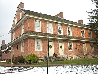
Dilworthtown is an unincorporated community and census-designated place (CDP) in Chester and Delaware counties, Pennsylvania, United States. It was first listed as a CDP prior to the 2020 census.
Castleton Four Corners is a census-designated place (CDP) in the town of Castleton, Rutland County, Vermont, United States. It consists of the unincorporated villages of Castleton Corners and Hydeville. As of the 2020 census, the CDP had a population of 699, out of 4,458 in the entire town.


