Clarendon, Vermont

Last updated

Clarendon, Vermont
Clarendon House, Clarendon Springs, Vermont.jpg
Clarendon House, Clarendon Springs
Clarendon vt highlight.png
Clarendon, Vermont
Coordinates: 43°32′N72°58′W / 43.533°N 72.967°W / 43.533; -72.967
Country United States
State Vermont
County Rutland
Communities
Area
  Total31.6 sq mi (81.7 km2)
  Land31.6 sq mi (81.7 km2)
  Water0.0 sq mi (0.0 km2)
Elevation
538 ft (164 m)
Population
 (2020)
  Total2,412
  Density76/sq mi (30/km2)
Time zone UTC-5 (Eastern (EST))
  Summer (DST) UTC-4 (EDT)
ZIP code
05759
Area code 802
FIPS code 50-14500 [1]
GNIS feature ID1462072 [2]

Clarendon is a town in Rutland County, Vermont, United States. The population was 2,412 at the 2020 census. [3] Clarendon spans U.S. Route 7 and is split by the highway, the Cold River and Mill River, Otter Creek, and the Green Mountains into the hamlets of Clarendon, West Clarendon, East Clarendon, Clarendon Springs, and North Clarendon

Contents

History

The area that later formed the Town of Clarendon was settled by families from lower New England as early as 1762. It and the surrounding area was then part of Albany County, New York, but was later split off as Charlotte County until Vermont declared itself as a republic around 1777. Land claims by New Hampshire were eventually settled, and in 1791 Vermont became a state.

Clarendon now includes the following entries on the National Register of Historic Places:

Geography

According to the United States Census Bureau, the town has a total area of 31.6 square miles (81.7 km2), all land.

The Clarendon Gorge, accessible using the combined Appalachian Trail/Long Trail, is a popular local geographical feature. One must cross a 30-foot-long (9.1 m) suspension bridge to reach the waterfall and swimming holes as well as to connect with the Appalachian Trail National Scenic Trail.

Clarendon Gorge (Upper Falls):

Demographics

Historical population
CensusPop.Note
1790 1,478
1800 1,78921.0%
1810 1,7970.4%
1820 1,712−4.7%
1830 1,585−7.4%
1840 1,549−2.3%
1850 1,477−4.6%
1860 1,237−16.2%
1870 1,173−5.2%
1880 1,105−5.8%
1890 928−16.0%
1900 915−1.4%
1910 857−6.3%
1920 826−3.6%
1930 8836.9%
1940 868−1.7%
1950 1,10227.0%
1960 1,091−1.0%
1970 1,53740.9%
1980 2,37254.3%
1990 2,83519.5%
2000 2,811−0.8%
2010 2,571−8.5%
2020 2,412−6.2%
U.S. Decennial Census [5]

As of the census [1] of 2000, there were 2,811 people, 1,136 households, and 784 families residing in the town. The population density was 89.1 people per square mile (34.4/km2). There were 1,207 housing units at an average density of 38.3 per square mile (14.8/km2). The racial makeup of the town was 98.08% White, 0.28% African American, 0.32% Native American, 0.57% Asian, 0.21% from other races, and 0.53% from two or more races. Hispanic or Latino of any race were 0.50% of the population.

There were 1,136 households, out of which 31.2% had children under the age of 18 living with them, 58.0% were married couples living together, 7.5% had a female householder with no husband present, and 30.9% were non-families. 24.0% of all households were made up of individuals, and 7.4% had someone living alone who was 65 years of age or older. The average household size was 2.47 and the average family size was 2.94.

In the town, the population was spread out, with 23.1% under the age of 18, 6.8% from 18 to 24, 27.7% from 25 to 44, 32.1% from 45 to 64, and 10.4% who were 65 years of age or older. The median age was 42 years. For every 100 females, there were 97.1 males. For every 100 females age 18 and over, there were 98.2 males.

The median income for a household in the town was $41,597, and the median income for a family was $48,534. Males had a median income of $31,122 versus $24,375 for females. The per capita income for the town was $19,801. About 5.4% of families and 7.7% of the population were below the poverty line, including 8.3% of those under age 18 and 12.7% of those age 65 or over

Mill River Union High School MRU-North-Clarendon-VT-Jun-21-2018-1.jpg
Mill River Union High School

Education

The students of Clarendon are served by two schools. Clarendon Elementary School for students in Pre-K through 6th grade and Mill River Union High School for students in grades 7–12. Prior to 2016, both schools were a part of the Rutland South Supervisory Union, but merged via Act 153 into the Mill River Unified Union School District. [6] As of 2015, 46% of Clarendon students attended Clarendon Elementary School and 54% attended Mill River Union High School. [7]

Clarendon Elementary School Clarendon Elementary School.jpg
Clarendon Elementary School

Notable people

Related Research Articles

<span class="mw-page-title-main">Rutland County, Vermont</span> County in Vermont, United States

Rutland County is a county located in the U.S. state of Vermont. As of the 2020 census, the population was 60,572, making it the second-most populous county in Vermont. Its county seat and most populous municipality is the city of Rutland.

<span class="mw-page-title-main">Bennington County, Vermont</span> County in Vermont, United States

Bennington County is a county in the U.S. state of Vermont. As of the 2020 census, the population was 37,347. The shire towns are jointly Bennington and Manchester, and the largest municipality is Bennington. The county was created in 1778.

<span class="mw-page-title-main">Lunenburg, Vermont</span> Town in Vermont, United States

Lunenburg is a town in Essex County, Vermont, United States. The population was 1,246 at the 2020 census, the most populous in Essex County. Lunenburg contains the villages of Lunenburg and Gilman and hamlets of West Lunenburg, South Lunenburg, and Mill Village, and is part of the Berlin, NH –VT Micropolitan Statistical Area.

<span class="mw-page-title-main">Eden, Vermont</span> Town in Vermont, United States

Eden is a town in Lamoille County, Vermont, United States. The population was 1,338 at the 2020 census.

<span class="mw-page-title-main">Craftsbury, Vermont</span> Town in Vermont, United States

Craftsbury is a town in Orleans County, Vermont, United States. The population was 1,343 at the 2020 census. The town includes the unincorporated villages of Craftsbury, Craftsbury Common, Mill Village, and East Craftsbury.

<span class="mw-page-title-main">Mendon, Vermont</span> Town in Vermont, United States

Mendon is a town in Rutland County, Vermont, United States. The population was 1,149 at the 2020 census.

<span class="mw-page-title-main">Pawlet, Vermont</span> Town in Vermont, United States

Pawlet is a town in Rutland County, Vermont, United States. The population was 1,424 at the 2020 census.

<span class="mw-page-title-main">Proctor, Vermont</span> Town in Vermont, United States

Proctor is a town in Rutland County, Vermont, United States. The population was 1,763 at the 2020 census. Proctor is home to the Vermont Marble Museum and Wilson Castle.

<span class="mw-page-title-main">Shrewsbury, Vermont</span> Town in Vermont, United States

Shrewsbury is a town in Rutland County, Vermont, United States. The town was named for the Earl of Shrewsbury. The population was 1,096 at the 2020 census.

<span class="mw-page-title-main">Tinmouth, Vermont</span> Town in Vermont, United States

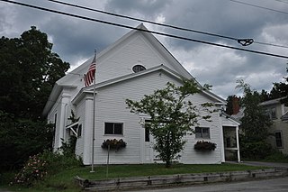
Tinmouth is a town in Rutland County, Vermont, United States. The population was 553 at the 2020 census.

<span class="mw-page-title-main">Rockingham, Vermont</span> Town in Vermont, United States

Rockingham is a town along the Connecticut River in Windham County, Vermont, United States. As of the 2020 census, the population was 4,832. Rockingham includes the incorporated villages of Bellows Falls and Saxtons River, as well as a large rural area west of Interstate 91.

<span class="mw-page-title-main">White River Junction, Vermont</span> Census-designated place in Vermont, United States

White River Junction is an unincorporated village and census-designated place (CDP) in the town of Hartford in Windsor County, Vermont, United States. The population was 2,528 at the 2020 census, up from 2,286 in 2010, making it the largest community within the town of Hartford.

<span class="mw-page-title-main">Springfield, Vermont</span> Town in Vermont, United States

Springfield is a town in Windsor County, Vermont, United States. As of the 2020 census, the population was 9,062.

<span class="mw-page-title-main">Middlebury, Vermont</span> Town in Vermont, United States

Middlebury is the shire town of Addison County, Vermont, United States. As of the 2020 census, the population was 9,152. Middlebury is home to Middlebury College and the Henry Sheldon Museum of Vermont History.

<span class="mw-page-title-main">Jericho, Vermont</span> Town in Vermont, United States

Jericho is a town in Chittenden County, Vermont, United States. As of the 2020 census, the population was 5,104. The town was named after the ancient city of Jericho.

<span class="mw-page-title-main">Northfield, Vermont</span> Town in Vermont, United States

Northfield is a town in Washington County, Vermont, United States. The town lies in a valley within the Green Mountains and has been home to Norwich University since 1866. It contains the village of Northfield, where over half of the population lives. The town's total population was 5,918 at the 2020 census.

<span class="mw-page-title-main">Ludlow (village), Vermont</span> Village in Vermont, United States

Ludlow is an incorporated village within the town of Ludlow, Windsor County, Vermont, United States. It is sometimes called Ludlow Village, to distinguish it from the surrounding town of the same name. The population was 773 at the 2020 census.

<span class="mw-page-title-main">Rutland (city), Vermont</span> City in Vermont, United States

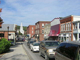
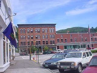
Rutland is the only city in and the seat of Rutland County, Vermont, United States. As of the 2020 census, the city had a total population of 15,807. It is located approximately 65 miles (105 km) north of the Massachusetts state line, 35 miles (56 km) west of New Hampshire state line, and 20 miles (32 km) east of the New York state line. Rutland is the third largest city in the state of Vermont after Burlington and South Burlington. Rutland City is completely surrounded by Rutland Town, which is a separate municipality. The downtown area of the city is listed as a historic district on the National Register of Historic Places.

<span class="mw-page-title-main">West Rutland, Vermont</span> Town in Vermont, United States

West Rutland is a town in Rutland County, Vermont, United States. The population was 2,214 at the 2020 census. The town center, located in the south-central portion of the town and where about 87% of the population resides, is defined by the U.S. Census Bureau as a census-designated place (CDP). The town is part of the Rutland micropolitan NECTA.

<span class="mw-page-title-main">Bradford, Vermont</span> Town in Vermont, United States

Bradford is a town in Orange County, Vermont, United States. The population was 2,790 at the 2020 census. Bradford is located on the county's eastern border, bordering both the Connecticut River and New Hampshire, and is a commercial center for some of its surrounding towns.

References

  1. 1 2 "U.S. Census website". United States Census Bureau . Retrieved January 31, 2008.
  2. "US Board on Geographic Names". United States Geological Survey. October 25, 2007. Retrieved January 31, 2008.
  3. "Census - Geography Profile Clarendon town, Rutland County, Vermont". United States Census Bureau . Retrieved December 29, 2021.
  4. New England Waterfalls. Retrieved November 4, 2010.
  5. "U.S. Decennial Census". United States Census Bureau. Retrieved May 16, 2015.
  6. "Merger Documents | Mill River Schools". millriverschools.org. Retrieved September 26, 2018.
  7. "Clarendon Draft Town Plan 2016" (PDF).
  8. Queen's University at Kingston, Douglas Library Notes, Volume 16, Issue 3, 1968, page 26
  9. Chauncey C. Olin, A Complete Record of the John Olin Family, 1893, page 83
  10. John D. Wright, The Routledge Encyclopedia of Civil War Era Biographies, 2012, page 176
  11. John J. Duffy, Samuel B. Hand, Ralph H. Orth, The Vermont Encyclopedia, 2003, page 151
  12. Abby Maria Hemenway, Vermont Historical Gazetteer, Volume 3, 1877, page 567
  13. Middlebury College, Catalogue of Officers and Students of Middlebury College, 1901, page 67
  14. Minnesota Legislators: Past & Present-Harrison J. Peck
  15. Frances Manwaring Caulkins, History of Norwich, Connecticut, 1866, page 237
  16. Charles L. Williams, Statistics of the Rutland County Bar, 1847, page 8