Caldwell County, Missouri

Last updated

Caldwell County
Caldwell County Missouri Courthouse 20191027-7106.jpg
Caldwell County courthouse in Kingston
Map of Missouri highlighting Caldwell County.svg
Location within the U.S. state of Missouri
Missouri in United States.svg
Missouri's location within the U.S.
Coordinates: 39°40′N93°59′W / 39.66°N 93.98°W / 39.66; -93.98
CountryFlag of the United States.svg United States
StateFlag of Missouri.svg  Missouri
FoundedDecember 29, 1836
Named for John Caldwell
Seat Kingston
Largest city Hamilton
Area
  Total430 sq mi (1,100 km2)
  Land426 sq mi (1,100 km2)
  Water3.2 sq mi (8 km2)  0.8%
Population
 (2020)
  Total8,815
  Density21/sq mi (7.9/km2)
Time zone UTC−6 (Central)
  Summer (DST) UTC−5 (CDT)
Congressional district 6th
Website www.caldwellco.missouri.org

Caldwell County is a county located in Missouri, United States. As of the 2020 census, the county's population was 8,815. It is part of the Kansas City metropolitan area. [1] Its county seat is Kingston. [2] The county was organized December 29, 1836, and named by Alexander Doniphan to honor John Caldwell, who participated in George Rogers Clark's Native American Campaign of 1786 and was the second Lieutenant Governor of Kentucky.

Contents

Caldwell County was originally established as a haven for Mormons, who had been driven from Jackson County in November 1833, and had been refugees in adjacent Clay County since. The county was one of the principal settings of the 1838 Missouri Mormon War, which led to the expulsion of all Latter Day Saints from Missouri, following the issuance of an "extermination order" by then–Governor Lilburn Boggs.

History

Mormon settlement

Monument at the temple site in Far West, Missouri. FarWestMonument.jpg
Monument at the temple site in Far West, Missouri.

Caldwell County was originally part of Ray County. The first white settler was Jesse Mann Sr., who settled one-half mile northeast of the public square of Kingston on Shoal Creek in 1831. The early settlers moved back south in 1832 for better protection during the Black Hawk War uprising.

A few Mormon settlers, who had been evicted from Jackson County, Missouri, moved into the county in 1832, and included Jacob Hawn, whose mill on Shoal Creek would become the scene of the bloodiest incident in the Mormon War, known as the Hawn's Mill Massacre.

The settlers established Salem, the first town in the county, two miles southeast of Kingston. A larger number of Mormons moved to the county in the fall of 1836. The Missouri General Assembly created Caldwell County in December 1836, with the understanding that it would be dedicated to Mormon settlers. Its county seat was Far West, Missouri. By 1838 Far West reported a population of 4,000. [3]

The major figures of early Mormon history, including Joseph Smith, Hyrum Smith, Brigham Young, John Taylor, Edward Partridge, Sidney Rigdon, Parley P. Pratt and John D. Lee, were included in the migration.

Mormon War

Mormon settlers moved further north into Daviess County, particularly at Adam-ondi-Ahman, after Smith proclaimed that it was the Biblical place where Adam and Eve were banished after leaving the Garden of Eden. He said it would be a gathering place on the Judgement Day. The Mormon War erupted following a skirmish between original Missouri settlers and Mormon settlers in the Gallatin Election Day Battle.

After the Missouri militia was routed in the Battle of Crooked Creek, Governor Lilburn Boggs issued Missouri Executive Order 44 (Mormon Extermination Order) to evict the Mormons from the state. Three days later, a group from Livingston County killed 18 Mormons in the Hawn's Mill massacre. Troops laid siege to Far West, where Smith surrendered in October 1838. The settlers agreed to leave; they abandoned Far West and initially regrouped in Quincy, Illinois, for the winter of 1838–39. The following spring, they founded Nauvoo, Illinois.

Following the dissolution of Far West, the county seat was moved to present-day Kingston.

Geography

According to the U.S. Census Bureau, the county has a total area of 430 square miles (1,100 km2), of which 426 square miles (1,100 km2) is land and 3.2 square miles (8.3 km2) (0.8%) is water. [4]

Adjacent counties

[5]

Major highways

Demographics

Historical population
CensusPop.Note
1840 1,458
1850 2,31058.4%
1860 5,034117.9%
1870 11,390126.3%
1880 13,64619.8%
1890 15,15211.0%
1900 16,6569.9%
1910 14,605−12.3%
1920 13,849−5.2%
1930 12,509−9.7%
1940 11,629−7.0%
1950 9,929−14.6%
1960 8,830−11.1%
1970 8,351−5.4%
1980 8,6603.7%
1990 8,380−3.2%
2000 8,9697.0%
2010 9,4245.1%
2020 8,815−6.5%
U.S. Decennial Census [6]
1790-1960 [7] 1900-1990 [8]
1990-2000 [9] 2010-2015 [1]

As of the census [10] of 2000, there were 8,969 people, 3,523 households, and 2,501 families residing in the county. The population density was 8/km2 (21/sq mi). There were 4,493 housing units at an average density of 4/km2 (10/sq mi). The racial makeup of the county was 98.56% White, 0.13% Black or African American, 0.33% Native American, 0.12% Asian, 0.00% Pacific Islander, 0.18% from other races, and 0.67% from two or more races. 0.75% of the population were Hispanic or Latino of any race.

There were 3,523 households, out of which 32.30% had children under the age of 18 living with them, 59.20% were married couples living together, 8.00% had a female householder with no husband present, and 29.00% were non-families. 25.50% of all households were made up of individuals, and 13.00% had someone living alone who was 65 years of age or older. The average household size was 2.51, and the average family size was 3.04.

In the county, the population was spread out, with 27.10% under the age of 18, 7.10% from 18 to 24, 25.10% from 25 to 44, 23.70% from 45 to 64, and 17.00% who were 65 years of age or older. The median age was 39 years. For every 100 females there were 97.60 males. For every 100 females age 18 and over, there were 93.90 males.

The median income for a household in the county was $31,240, and the median income for a family was $37,087. Males had a median income of $28,710 versus $19,523 for females. The per capita income for the county was $15,343. 11.90% of the population and 9.70% of families were below the poverty line. Out of the total population, 15.10% of those under the age of 18 and 12.90% of those 65 and older were living below the poverty line.

2020 Census

Caldwell County Racial Composition [11]
RaceNum.Perc.
White (NH)8,17293%
Black or African American (NH)651%
Native American (NH)340.4%
Asian (NH)260.3%
Pacific Islander (NH)70.08%
Other/Mixed (NH)3604.1%
Hispanic or Latino 1511.7%

Education

Public Schools

Public libraries

Communities

Cities

Ghost town

Townships

Caldwell County is divided into 12 townships

Unincorporated Communities

Notable people

Politics

Local

The Republican Party controls politics at the local level in Caldwell County. Republicans hold all but one of the elected positions in the county.

Caldwell County, Missouri
Elected countywide officials
Assessor Beverly Alden Republican
Circuit Clerk Carrie Miller Democratic
County Clerk Christine Owen Republican
Commissioner
(Presiding)
C.R. (Bud) Motsinger Republican
Commissioner
(District 1)
Jonathan Abbott Republican
Commissioner
(District 2)
Rex J. Hibler Republican
Coroner Dana Brown Republican
Prosecuting Attorney Brady C. Kopek Republican
Public Administrator Richard Lee Republican
Recorder Julie Hill Republican
Sheriff Mitchell K. Allen Republican
Treasurer June Grooms Republican

State

Past Gubernatorial Elections Results
Year Republican Democratic Third Parties
2020 77.48%3,60319.70% 9162.82% 131
2016 63.10%2,27633.40% 1,4433.50% 151
2012 50.39%2,09245.33% 1,8824.29% 178
2008 44.58% 2,01452.26%2,3613.16% 143
2004 56.40%2,41941.87% 1,7961.73% 74
2000 52.01%2,00644.10% 1,7013.89% 150
1996 38.04% 1,31458.80%2,0313.16% 109

All of Caldwell County is a part of Missouri's 8th District in the Missouri House of Representatives and is currently represented by Randy Railsback (R-Hamilton).

Missouri House of Representatives — District 8 — Caldwell County (2020)
PartyCandidateVotes%±%
Republican Randy Railsback4,203100.00%+21.81
Missouri House of Representatives — District 8 — Caldwell County (2018)
PartyCandidateVotes%±%
Republican James W. (Jim) Neely2,90778.19%-21.81
Democratic Caleb McKnight81121.81%+21.81

All of Caldwell County is a part of Missouri's 21st District in the Missouri Senate and is currently represented by Denny Hoskins (R-Warrensburg).

Missouri Senate — District 21 — Caldwell County (2020)
PartyCandidateVotes%±%
Republican Denny Hoskins3,65183.55%+10.57
Libertarian Mark Bliss71916.46%+10.05
Missouri Senate — District 21 — Caldwell County (2016)
PartyCandidateVotes%±%
Republican Denny Hoskins3,03972.98%+6.24
Democratic ElGene Ver Dught85820.61%-5.37
Libertarian Bill Wayne2676.41%-0.87

Federal

All of Caldwell County is included in Missouri's 6th Congressional District and is currently represented by Sam Graves (R-Tarkio) in the U.S. House of Representatives. Graves was elected to an eleventh term in 2020 over Democratic challenger Gena Ross.

U.S. House of Representatives – Missouri’s 6th Congressional District – Caldwell County (2020)
PartyCandidateVotes%±%
Republican Sam Graves3,69380.23%+3.27
Democratic Gena L. Ross76916.69%-3.45
Libertarian Jim Higgins1423.09%+0.19
U.S. House of Representatives – Missouri's 6th Congressional District – Caldwell County (2018)
PartyCandidateVotes%±%
Republican Sam Graves2,89376.96%+2.34
Democratic Henry Robert Martin75720.14%-0.09
Libertarian Dan Hogan1092.90%-0.71

Caldwell County, along with the rest of the state of Missouri, is represented in the U.S. Senate by Josh Hawley (R-Columbia) and Roy Blunt (R-Strafford).

U.S. Senate – Class I – Caldwell County (2018)
PartyCandidateVotes%±%
Republican Josh Hawley2,55867.71%+22.23
Democratic Claire McCaskill1,02227.05%-17.27
Independent Craig O'Dear1022.70%
Libertarian Japheth Campbell701.85%-8.36
Green Jo Crain260.69%+0.69

Blunt was elected to a second term in 2016 over then-Missouri Secretary of State Jason Kander.

U.S. Senate — Class III — Caldwell County (2016)
PartyCandidateVotes%±%
Republican Roy Blunt2,51358.25%+12.77
Democratic Jason Kander1,51735.16%-9.15
Libertarian Jonathan Dine1533.55%-6.66
Green Johnathan McFarland781.81%+1.81
Constitution Fred Ryman531.23%+1.23
United States presidential election results for Caldwell County, Missouri [14]
Year Republican Democratic Third party
No.%No.%No.%
2020 3,72579.32%89719.10%741.58%
2016 3,23274.95%83819.43%2425.61%
2012 2,72165.30%1,31231.49%1343.22%
2008 2,65458.15%1,81439.75%962.10%
2004 2,59360.75%1,64538.54%300.70%
2000 2,22057.66%1,48838.65%1423.69%
1996 1,46442.21%1,48742.88%51714.91%
1992 1,29531.94%1,45635.91%1,30432.16%
1988 2,07454.38%1,72645.25%140.37%
1984 2,67865.96%1,38234.04%00.00%
1980 2,55160.36%1,54136.46%1343.17%
1976 2,09449.47%2,11349.92%260.61%
1972 3,16772.01%1,23127.99%00.00%
1968 2,63157.81%1,49032.74%4309.45%
1964 2,12546.20%2,47553.80%00.00%
1960 3,11564.21%1,73635.79%00.00%
1956 3,21662.51%1,92937.49%00.00%
1952 3,75566.83%1,86033.10%40.07%
1948 2,68757.46%1,98542.45%40.09%
1944 3,38462.75%2,00137.10%80.15%
1940 3,97659.23%2,72840.64%90.13%
1936 3,79255.66%3,01444.24%70.10%
1932 2,68847.35%2,94951.95%400.70%
1928 4,16765.82%2,16434.18%00.00%
1924 3,54558.66%2,38339.43%1151.90%
1920 4,16862.32%2,49837.35%220.33%
1916 2,06954.74%1,68344.52%280.74%
1912 1,18732.31%1,48340.36%1,00427.33%
1908 2,16157.55%1,54041.01%541.44%
1904 2,27660.92%1,35036.13%1102.94%
1900 2,23554.81%1,72242.23%1212.97%
1896 2,11550.18%2,05348.71%471.12%
1892 1,75047.17%1,38837.41%57215.42%
1888 1,85351.60%1,52842.55%2105.85%

Missouri presidential preference primaries

2020

The 2020 presidential primaries for both the Democratic and Republican parties were held in Missouri on March 10. On the Democratic side, former Vice President Joe Biden (D-Delaware) both won statewide and carried Caldwell County by a wide margin. Biden went on to defeat President Donald Trump in the general election.

Missouri Democratic Presidential Primary – Caldwell County (2020)
PartyCandidateVotes%±%
Democratic Joe Biden33460.62
Democratic Bernie Sanders15828.68
Democratic Tulsi Gabbard91.63
Democratic Others/Uncommitted509.07

Incumbent President Donald Trump (R-Florida) faced a primary challenge from former Massachusetts Governor Bill Weld, but won both Caldwell County and statewide by overwhelming margins.

Missouri Republican Presidential Primary – Caldwell County (2020)
PartyCandidateVotes%±%
Republican Donald Trump69297.06
Republican Bill Weld81.12
Republican Others/Uncommitted131.82

2016

The 2016 presidential primaries for both the Republican and Democratic parties were held in Missouri on March 15. Businessman Donald Trump (R-New York) narrowly won the state overall, as well as a plurality of the vote in Caldwell County.

Missouri Republican Presidential Primary – Caldwell County (2016)
PartyCandidateVotes%±%
Republican Donald Trump78043.67
Republican Ted Cruz70139.25
Republican John Kasich1498.34
Republican Marco Rubio965.38
Republican Others/Uncommitted603.36

On the Democratic side, former Secretary of State Hillary Clinton (D-New York) won statewide by a small margin, but lost Caldwell County to Senator Bernie Sanders (I-Vermont).

Missouri Democratic Presidential Primary – Caldwell County (2016)
PartyCandidateVotes%±%
Democratic Bernie Sanders31455.58
Democratic Hillary Clinton24443.19
Democratic Others/Uncommitted71.24

2012

The 2012 Missouri Republican Presidential Primary's results were nonbinding on the state's national convention delegates. Voters in Caldwell County supported former U.S. Senator Rick Santorum (R-Pennsylvania), who finished first in the state at large, but eventually lost the nomination to former Governor Mitt Romney (R-Massachusetts). Delegates to the congressional district and state conventions were chosen at a county caucus, which selected delegations favoring Romney.

2008

In 2008, the Missouri Republican Presidential Primary was closely contested, with Senator John McCain (R-Arizona) prevailing and eventually winning the nomination.

Missouri Republican Presidential Primary – Caldwell County (2008)
PartyCandidateVotes%±%
Republican John McCain36336.05
Republican Mike Huckabee30229.99
Republican Mitt Romney24224.03
Republican Ron Paul777.65
Republican Others/Uncommitted232.28

Then-Senator Hillary Clinton (D-New York) received more votes than any candidate from either party in Caldwell County during the 2008 presidential primary. Despite initial reports that Clinton had won Missouri, Barack Obama (D-Illinois), also a Senator at the time, narrowly defeated her statewide and later became that year's Democratic nominee, going on to win the presidency.

Missouri Democratic Presidential Primary – Caldwell County (2008)
PartyCandidateVotes%±%
Democratic Hillary Clinton61659.40
Democratic Barack Obama37936.55
Democratic Others/Uncommitted424.06

See also

Related Research Articles

<span class="mw-page-title-main">Clinton County, Missouri</span> County in Missouri, United States

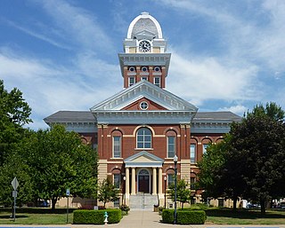
Clinton County is a county located in the U.S. state of Missouri and is part of the Kansas City metropolitan area. As of the 2020 U.S. Census, the county had a population of 21,184. Its county seat is Plattsburg. The county was organized January 2, 1833, and named for Governor DeWitt Clinton of New York. The county seat of Plattsburg derives its name from a town of a similar name that is the county seat of Clinton County, New York, which was also named for the Governor.

<span class="mw-page-title-main">Wright County, Missouri</span> County in Missouri, United States

Wright County is a county located in the southern portion of the U.S. state of Missouri. As of the 2020 census, the population was 18,188. Its county seat is Hartville. The county was officially organized on January 29, 1841, and is named after Silas Wright, a former Congressman, U.S. Senator and Governor of New York.

<span class="mw-page-title-main">Saline County, Missouri</span> County in Missouri, United States

Saline County is a county located along the Missouri River in the U.S. state of Missouri. As of the 2020 census, the population was 23,333. Its county seat is Marshall. The county was established November 25, 1820, and named for the region's salt springs.

<span class="mw-page-title-main">Ray County, Missouri</span> County in Missouri, United States

Ray County is a county located in the northwestern portion of the U.S. state of Missouri and is part of the Kansas City metropolitan area. As of the 2020 census, the population was 23,158. Its county seat is Richmond. The county was organized November 16, 1820, and named for John Ray, a Missouri state legislator and member of the first state Constitutional Convention.

<span class="mw-page-title-main">Platte County, Missouri</span> County in Missouri, United States

Platte County is a county located in the northwestern portion of the U.S. state of Missouri and is part of the Kansas City metropolitan area. As of the 2020 census, the population was 106,718. Its county seat is Platte City. The county was organized December 31, 1838, from the Platte Purchase, named for the Platte River. The Kansas City International Airport is located in the county, approximately one mile west of Interstate 29 between mile markers 12 and 15. The land for the airport was originally in an unincorporated portion of Platte County before being annexed by Platte City, and eventually Kansas City.

<span class="mw-page-title-main">Livingston County, Missouri</span> County in Missouri, United States

Livingston County is a county located in the northwestern portion of the U.S. state of Missouri. As of the 2020 census, the population was 14,557. Its county seat is Chillicothe. The county was organized January 6, 1837, and named for U.S. Secretary of State Edward Livingston.

<span class="mw-page-title-main">Lincoln County, Missouri</span> County in Missouri, United States

Lincoln County is located in the eastern part of the U.S. state of Missouri. As of the 2020 census, the population was 59,574. Its county seat is Troy. The county was founded December 14, 1818, and named for Major General Benjamin Lincoln of the American Revolutionary War.

<span class="mw-page-title-main">Laclede County, Missouri</span> County in Missouri, United States

Laclede County is a county located in the U.S. state of Missouri. As of the 2020 census, the population was 36,039. Its county seat is Lebanon. The county was organized February 24, 1849, and was named after Pierre Laclède, founder of St. Louis.

<span class="mw-page-title-main">Howell County, Missouri</span> County in Missouri, United States

Howell County is in southern Missouri. As of the 2020 census, the population was 39,750. The largest city and county seat is West Plains. The county was officially organized on March 2, 1851, and is named after Josiah Howell, a pioneer settler in the Howell Valley.

<span class="mw-page-title-main">Harrison County, Missouri</span> County in Missouri, United States

Harrison County is a county located in the northwest portion of the U.S. state of Missouri. As of the 2020 census, the population was 8,157. It's county seat is Bethany. The county was organized February 14, 1845, and named for U.S. Representative Albert G. Harrison of Missouri.

<span class="mw-page-title-main">Daviess County, Missouri</span> County in Missouri, United States

Daviess County is a county located in the U.S. state of Missouri. As of the 2020 census, the population was 8,430. Its county seat is Gallatin. The county was organized December 29, 1836, from Ray County and named for Major Joseph Hamilton Daveiss, a soldier from Kentucky who was killed in 1811 at the Battle of Tippecanoe.

<span class="mw-page-title-main">Cooper County, Missouri</span> County in Missouri, United States

Cooper County is located in the central portion of the U.S. state of Missouri. As of the 2020 United States census, the population was 17,103. Its county seat is Boonville. The county was organized December 17, 1818, and named for Sarshell Cooper, a frontier settler who was killed by Native Americans near Arrow Rock in 1814. It is a part of the Columbia, Missouri metropolitan area.

<span class="mw-page-title-main">Cole County, Missouri</span> County in Missouri, United States

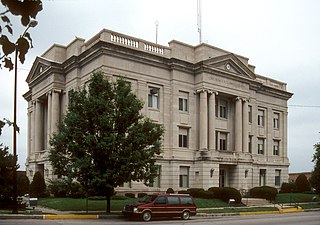
Cole County is located in the central part of the U.S. state of Missouri. As of the 2020 census, its population was 77,279. Its county seat and largest city is Jefferson City, the state capital. The county was organized November 16, 1820, and named after pioneer William Temple Cole who built Cole's Fort in Boonville.

<span class="mw-page-title-main">Chariton County, Missouri</span> County in Missouri, United States

Chariton County is a county located in the north-central portion of the U.S. state of Missouri. As of the 2020 census, the population was 7,408. Its county seat is Keytesville. The county was organized November 16, 1820, from part of Howard County and is named for the Chariton River.

<span class="mw-page-title-main">Cass County, Missouri</span> County in Missouri, United States

Cass County is a county located in the western part of the U.S. state of Missouri and is part of the Kansas City metropolitan area. As of the 2020 census, the population was 107,824. Its county seat is Harrisonville; however, the county contains a portion of Kansas City, Missouri. The county was organized in 1835 as Van Buren County, but was renamed in 1849 after U.S. Senator Lewis Cass of Michigan, who later became a presidential candidate.

<span class="mw-page-title-main">Carroll County, Missouri</span> County in Missouri, United States

Carroll County is a county located in the U.S. state of Missouri. As of the 2020 census, the county had a population of 8,495. Its county seat is Carrollton. The county was organized on January 2, 1833, from part of Ray County and named for Charles Carroll of Carrollton, a signer of the Declaration of Independence.

<span class="mw-page-title-main">Camden County, Missouri</span> County in Missouri, United States

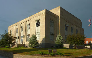
Camden County is a county located in the U.S. state of Missouri. As of the 2020 Census, the population was 42,745. Its county seat is Camdenton. The county was organized on January 29, 1841, as Kinderhook County and renamed Camden County in 1843 after Charles Pratt, 1st Earl Camden, Lord Chancellor of the United Kingdom and leader of the British Whig Party. Camden County is also the primary setting of the Netflix show Ozark.

<span class="mw-page-title-main">Buchanan County, Missouri</span> County in Missouri, United States

Buchanan County is located in the U.S. state of Missouri. As of the 2020 United States Census, the population was 84,793. Its county seat is St. Joseph. When originally formed in 1838, the county was named Roberts County, after settler Hiram Roberts. It was renamed in 1839 for James Buchanan, then a U.S. Senator and later President of the United States. The county was formed from land annexed to Missouri, as were five other counties.

<span class="mw-page-title-main">Boone County, Missouri</span> County in Missouri, United States

Boone County is located in the U.S. state of Missouri. Centrally located in Mid-Missouri, its county seat is Columbia, Missouri's fourth-largest city and location of the University of Missouri. As of the 2020 census, the population was 183,610, making it the state's eighth-most populous county. The county was organized November 16, 1820, and named for the then recently deceased Daniel Boone, whose kin largely populated the Boonslick area, having arrived in the 1810s on the Boone's Lick Road. Boone County comprises the Columbia Metropolitan Area. The towns of Ashland and Centralia are the second and third most populous towns in the county.

<span class="mw-page-title-main">Cowgill, Missouri</span> City in Missouri, United States

Cowgill is a city in southern Caldwell County, Missouri, and is part of the Kansas City metropolitan area with the United States. The population was 168 at the 2020 census.

References

  1. 1 2 "2020 Population and Housing State Data". United States Census Bureau. Archived from the original on November 18, 2023. Retrieved August 19, 2021.
  2. "Find a County". National Association of Counties. Archived from the original on May 31, 2011. Retrieved June 7, 2011.
  3. Archived September 8, 2008, at the Wayback Machine
  4. "2010 Census Gazetteer Files". United States Census Bureau. August 22, 2012. Archived from the original on October 21, 2013. Retrieved November 14, 2014.
  5. "MoDOT Traveler Information Map". traveler.modot.org. Archived from the original on March 23, 2018. Retrieved March 24, 2018.
  6. "U.S. Decennial Census". United States Census Bureau. Archived from the original on July 17, 2022. Retrieved November 14, 2014.
  7. "Historical Census Browser". University of Virginia Library. Archived from the original on August 11, 2012. Retrieved November 14, 2014.
  8. "Population of Counties by Decennial Census: 1900 to 1990". United States Census Bureau. Archived from the original on December 3, 2014. Retrieved November 14, 2014.
  9. "Census 2000 PHC-T-4. Ranking Tables for Counties: 1990 and 2000" (PDF). United States Census Bureau. Archived (PDF) from the original on March 27, 2010. Retrieved November 14, 2014.
  10. "U.S. Census website". United States Census Bureau. Archived from the original on July 9, 2021. Retrieved May 14, 2011.
  11. "P2 HISPANIC OR LATINO, AND NOT HISPANIC OR LATINO BY RACE – 2020: DEC Redistricting Data (PL 94-171) – Caldwell County, Missouri". Archived from the original on September 24, 2022. Retrieved September 24, 2022.
  12. Breeding, Marshall. "Breckenridge Public Library". Libraries.org. Archived from the original on April 18, 2021. Retrieved May 8, 2017.
  13. Breeding, Marshall. "Hamilton Public Library". Libraries.org. Archived from the original on April 18, 2021. Retrieved May 8, 2017.
  14. Leip, David. "Dave Leip's Atlas of U.S. Presidential Elections". uselectionatlas.org. Archived from the original on March 23, 2018. Retrieved March 24, 2018.

Sources

Commons-logo.svg Media related to Caldwell County, Missouri at Wikimedia Commons

39°40′N93°59′W / 39.66°N 93.98°W / 39.66; -93.98