Byron, California

Last updated

Byron
Byron sign.jpg
Byron sign
Contra Costa County California Incorporated and Unincorporated areas Byron Highlighted.svg
Location in Contra Costa County and the state of California
Usa edcp location map.svg
Red pog.svg
Byron
Location in the United States
Coordinates: 37°52′02″N121°38′17″W / 37.86722°N 121.63806°W / 37.86722; -121.63806
Country Flag of the United States (23px).png  United States
State Flag of California.svg  California
County Contra Costa
Government
   State senator Steve Glazer (D) [1]
   Assemblymember Lori Wilson (D) [2]
   U. S. rep. Josh Harder (D) [3]
Area
[4]
  Total6.52 sq mi (16.89 km2)
  Land6.52 sq mi (16.89 km2)
  Water0.00 sq mi (0.00 km2)  0%
Elevation
[5]
33 ft (10 m)
Population
 (2020)
  Total1,140
  Density174.82/sq mi (67.50/km2)
Time zone UTC-8 (Pacific)
  Summer (DST) UTC-7 (PDT)
ZIP code
94514
Area code 925
FIPS code 06-09346
GNIS feature IDs 238290, 2407934

Byron is a census designated place (CDP) [6] in Contra Costa County, California, United States.

Contents

History

Byron's location was part of a land grant that Jose Noriega received from the King of Spain in 1835. Noriega then sold 17,000 acres to John Marsh for the equivalent of $500 (three U.S. cents per acre). In 1841, the Bidwell-Bartelson wagon train arrived at Marsh's ranch with the earliest Anglo settlers from the east. [7]

Byron's first post office opened in 1878. [8] Byron is named after an employee of the San Pablo, and the eastern U. S. and Pacific Railroad. [lower-alpha 1]

In 1942, all of the town's residents of Japanese descent were forcibly removed by the US government with pressure from California agricultural interests and taken to Turlock assembly center. [9] [10]

In 1960, Contra Costa County built the Orin Allen Youth Rehabilitation Center, better known informally as the Boys' Ranch on a 50 acres (200,000 m2) tract immediately southeast of Byron. The Boys' Ranch is a minimum-security facility that houses up to 100 youthful offenders. The property has no security fence to contain residents within the perimeter and includes dormitories, classrooms, a kitchen and dining facility, athletic facilities and administrative offices which occupy about one-third of the area. Its objective was stated as rehabilitation, rather than simply detention. [11]

In 2008, a Contra Costa County Grand Jury began an investigation into whether the facility was cost-effective, or whether it should be permanently closed. It began by conducting an unannounced site inspection in September, 2008. In 2009, it released its report to the county commissioners. The report identified 21 defects at the facility that needed correction. [11]

Geography

According to the United States Census Bureau, the CDP has a total area of 6.5 square miles (17 km2), all of it land. It is located 5.5 miles (9 km) southeast of Brentwood. [8]

Climate

This region experiences hot and dry summers, with average monthly high temperatures varying from 55 degrees in January to 93 degrees in July. Byron is windy, and dust devils sometimes appear. According to the Köppen Climate Classification system, Byron has a warm-summer Mediterranean climate, abbreviated "Csb" on climate maps. [12]

Demographics

Historical population
CensusPop.Note
2020 1,140
U.S. Decennial Census [13]
1850–1870 [14] [15] 1880-1890 [16]
1900 [17] 1910 [18] 1920 [19]
1930 [20] 1940 [21] 1950 [22]
1960 [23] 1970 [24] 1980 [25]
1990 [26] 2000 [27] 2010 [28]

2010

At the 2010 census Byron had a population of 1,277. The population density was 196.8 inhabitants per square mile (76.0/km2). The racial makeup of Byron was 911 (71.3%) White, 61 (4.8%) African American, 11 (0.9%) Native American, 4 (0.3%) Asian, 11 (0.9%) Pacific Islander, 224 (17.5%) from other races, and 55 (4.3%) from two or more races. Hispanic or Latino of any race were 503 people (39.4%). [29]

The census reported that 1,177 people (92.2% of the population) lived in households, no one lived in non-institutionalized group quarters and 100 (7.8%) were institutionalized.

There were 389 households, 171 (44.0%) had children under the age of 18 living in them, 229 (58.9%) were opposite-sex married couples living together, 37 (9.5%) had a female householder with no husband present, 27 (6.9%) had a male householder with no wife present. There were 25 (6.4%) unmarried opposite-sex partnerships, and 3 (0.8%) same-sex married couples or partnerships. 76 households (19.5%) were one person and 25 (6.4%) had someone living alone who was 65 or older. The average household size was 3.03. There were 293 families (75.3% of households); the average family size was 3.50.

The age distribution was 405 people (31.7%) under the age of 18, 136 people (10.6%) aged 18 to 24, 306 people (24.0%) aged 25 to 44, 312 people (24.4%) aged 45 to 64, and 118 people (9.2%) who were 65 or older. The median age was 32.0 years. For every 100 females, there were 112.8 males. For every 100 females age 18 and over, there were 106.6 males.

There were 415 housing units at an average density of 64.0 per square mile (24.7/km2),of which 389 were occupied, 254 (65.3%) by the owners and 135 (34.7%) by renters. The homeowner vacancy rate was 3.0%; the rental vacancy rate was 3.6%. 759 people (59.4% of the population) lived in owner-occupied housing units and 418 people (32.7%) lived in rental housing units.

2000

At the 2000 census there were 916 people, 286 households, and 203 families in the CDP. The population density was 360.1 inhabitants per square mile (139.0/km2). There were 309 housing units at an average density of 121.5 per square mile (46.9/km2). The ethnic makeup of the CDP was 75.00% White, 4.37% Black or African American, 1.09% Native American, 2.18% Asian, 0.44% Pacific Islander, 14.74% from other races, and 2.18% from two or more races. 25.87% of the population were Hispanic or Latino of any race. [30]

Of the 286 households 36.4% had children under the age of 18 living with them, 53.8% were married couples living together, 11.5% had a female householder with no husband present, and 28.7% were non-families. 22.0% of households were one person and 9.8% were one person aged 65 or older. The average household size was 2.85 and the average family size was 3.36.

The age distribution was 35.0% under the age of 18, 9.1% from 18 to 24, 28.2% from 25 to 44, 18.8% from 45 to 64, and 9.0% 65 or older. The median age was 31 years. For every 100 females, there were 129.0 males. For every 100 females age 18 and over, there were 105.2 males.

The median household income was $35,938 and the median family income was $44,306. Males had a median income of $42,639 versus $28,889 for females. The per capita income for the CDP was $21,231. About 15.6% of families and 14.9% of the population were below the poverty line, including 33.3% of those under age 18 and none of those age 65 or over.

Former resort

37°50′54″N121°38′00″W / 37.84833°N 121.63333°W / 37.84833; -121.63333
Byron, California is also home to the somewhat well-known and historical Byron Hot Springs, a now-abandoned resort that was a retreat that attracted many movie stars and famous athletes in the early 1900s. The first hotel was built around 57 hot springs and owned by Lewis Mead in 1889. [31] The hotel included a three-story wood building, with a few cottages scattered nearby, as well as a laundry, gas plant and ice plant, all of which were destroyed by fire on July 25, 1901. A second hotel, also three stories, but made of stucco was constructed 1901–1902, but it burned on July 18, 1912. The third and final hotel, a four-story brick structure was built in 1913, reopened in 1914. [32]

In 1938 the resort closed, after a series of lawsuits that were probably brought about by the Great Depression, but was leased by the government in 1941 and became a military interrogation camp housing both German and Japanese prisoners of war, known as Camp Tracy, until 1945, when orders were sent to dismantle it. [33]

In 1947 Byron Hot Springs was put up for sale and purchased by the Greek Orthodox Church for $105,000. It served as Monastery St. Paul for several years. It then changed hands several times as a resort, country club, and private residence. In 2008, a developer announced plans to restore the resort. [34] As of 2021 a Byron Hot Springs website retains a "Resort Plans" page for the restoration of Byron Hot Springs. [35]

In 2005, a Victorian-era carriage house on the property was burned to the ground. The hotel itself sustained some fire damage, but still stands. [36]

Byron Hot Springs is 1.5 miles (2.4 km) south-southeast of Byron. [8] A post office operated at Byron Hot Springs from 1889 to 1930. [8]

Transportation

Byron Airport

In 1993 Contra Costa County broke ground on a new airport two miles (3 km) south of Byron. On October 8, 1994, Byron Airport was dedicated. The new airport has 1,307 acres (5.29 km2) of land. 814 acres (3.29 km2) are reserved for habitat management land for the San Joaquin kit fox, a federally listed endangered species, as well as many other endangered and special status species.

This is the home airport of the Patriots Jet Team. [37] It has also been used for illegal drag races in the past.

Notes

  1. Later acquired by the Southern Pacific Railroad [7] [8]

Related Research Articles

<span class="mw-page-title-main">Bear Valley, Alpine County, California</span> Census-designated place in California, United States

Bear Valley is a census-designated place in Alpine County, California, best known as the location of the Bear Valley ski area. The population was 121 at the 2010 census, down from 133 at the 2000 census.

<span class="mw-page-title-main">Bay Point, California</span> CDP in California, United States

Bay Point, formerly West Pittsburg and originally Bella Vista is a census-designated place located in the East Bay region of the San Francisco Bay Area in Contra Costa County, California. Bay Point is just west of Pittsburg, California, and northeast of Concord, California, on the southern shore of Suisun Bay. The population of Bay Point was 21,349 as of 2010. The Pittsburg/Bay Point Station of the Bay Area Rapid Transit (BART) rail system is located adjacent to Bay Point in Pittsburg. The community is traversed by a freeway, State Route 4, the California Delta Highway. Being unincorporated, Bay Point does not have its own police department. The community is policed by the California Highway Patrol and the Contra Costa County Sheriff's Office. The ZIP code is 94565, and the area code is 925.

<span class="mw-page-title-main">East Richmond Heights, California</span> Unincorporated community in California, United States

East Richmond Heights is an unincorporated community and census-designated place (CDP) in western Contra Costa County, California, United States. Its population was 3,280 at the 2010 census.

<span class="mw-page-title-main">Bear Valley Springs, California</span> Place in California, United States

Bear Valley Springs is a guarded-gate community in Kern County, California, United States. The unincorporated community is in the Tehachapi Mountains and is part of the greater Tehachapi area. The elevation ranges from 4,121 feet (1,256 m) to 6,934 feet (2,113 m). The population fluctuates between a low during the winter months when snow is common, to a high in the summer months when its elevation keeps it much cooler than surrounding areas and major cities. The population was 5,172 at the 2010 census, up from 4,232 at the 2000 census. For statistical purposes, the United States Census Bureau has defined Bear Valley Springs as a census-designated place (CDP). The census definition of the area may not precisely correspond to local understanding of the area with the same name.

<span class="mw-page-title-main">Cobb, California</span> Census designated place in California, United States

Cobb is a census designated place (CDP) in Lake County, California, United States. Cobb is located 1 mile (1.6 km) northwest of Whispering Pines, at an elevation of 2,631 feet (802 m). The population was 1,778 at the 2010 census, up from 1,638 at the 2000 census.

<span class="mw-page-title-main">Aromas, California</span> Census-designated place in California, United States

Aromas is an unincorporated community and census-designated place (CDP) in Monterey County and San Benito County, California, United States. The population was 2,708 at the 2020 census.

<span class="mw-page-title-main">Canyondam, California</span> Census-designated place in California, United States

Canyondam is a census-designated place (CDP) in Plumas County, United States. Canyondam is located near the dam that forms Lake Almanor, 6.25 miles (10.1 km) east-southeast of Almanor. The population was 31 as of the 2010 census, down from 37 as of the 2000 census. On August 6, 2021, the community was destroyed in the Dixie Fire.

<span class="mw-page-title-main">Chester, California</span> Census-designated place in California, United States

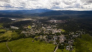
Chester is a census-designated place (CDP) in Plumas County, California, United States. Chester is located on Lake Almanor, 30 miles (48.3 km) north-northwest of Quincy. The town is located along State Route 36. The US Postal Service ZIP code for the community is 96020. The population was 2,144 at the 2010 census, down from 2,316 at the 2000 census.

<span class="mw-page-title-main">Cherry Valley, California</span> Census-designated place in California, United States

Cherry Valley is a census-designated place (CDP) in Riverside County, California, United States. The population was 6,362 at the 2010 census, up from 5,891 at the 2000 census. It is situated at the most northwestern point of the San Gorgonio Pass.

<span class="mw-page-title-main">August, California</span> Census-designated place in California, United States

August is a census-designated place (CDP) in San Joaquin County, California, United States. The population was 8,628 at the 2020 census, up from 8,390 at the 2010 census.

<span class="mw-page-title-main">Big Bend, California</span> Place in California, United States

Big Bend of the Madesi Valley is the indigenous homeland of the Madesi tribe, located in Shasta County, northeastern California. It is named for a major change in course of the Pit River.

<span class="mw-page-title-main">Boyes Hot Springs, California</span> Census designated place in California, United States

Boyes Hot Springs is a census-designated place (CDP) in Sonoma Valley, Sonoma County, California, United States. The population was 6,656 people at the 2010 census. Resorts in Boyes Hot Springs, El Verano, Fetters Hot Springs, and Agua Caliente were popular health retreats for tourists from San Francisco and points beyond until the middle of the 20th century because of the geothermic hot springs that still well up from deep within the Earth.

Bret Harte is a census-designated place (CDP) in Stanislaus County, California, United States. The population was 5,152 at the 2010 census, down from 5,161 at the 2000 census. It is part of the Modesto Metropolitan Statistical Area. It is named for the American poet and short story writer, Bret Harte, best known for his writings about the California Gold Rush.

Bayview is a census-designated place in Contra Costa County, California. Bayview sits at an elevation of 36 feet. The 2010 United States census reported Bayview's population was 1,754. Prior to 2010, Bayview was part of the Bayview-Montalvin CDP and then separated into the two individual communities of Bayview and Montalvin Manor for the census.

<span class="mw-page-title-main">Bethel Island</span> Census-designated place in California, United States

Bethel Island is an island in the Sacramento–San Joaquin River Delta of Contra Costa County, California, approximately 10 kilometres (6.2 mi) east of Antioch. The island describes itself as "the heart of the California Delta."

Acalanes Ridge is a census-designated place in Contra Costa County, California. Acalanes Ridge sits at an elevation of 499 feet (152 m). The population was 1,285 at the 2020 Census.

Castle Hill is a census-designated place in Contra Costa County, California. Castle Hill sits at an elevation of 302 feet (92 m). The 2010 United States census reported Castle Hill's population was 1,299.

<span class="mw-page-title-main">Contra Costa Centre, California</span> Census-designated place in California, United States

Contra Costa Centre is an unincorporated community and census-designated place in Contra Costa County, California. Contra Costa Centre sits at an elevation of 92 feet. The 2010 United States census reported Contra Costa Centre's population was 5,364, while the 2020 census figure was 6,808. Contra Costa Centre is served by the Pleasant Hill / Contra Costa Centre BART station.

San Miguel is a census-designated place in Contra Costa County, California. San Miguel sits at an elevation of 249 feet (76 m). The 2010 United States census reported San Miguel's population was 3,392.

Cold Springs is a census-designated place (CDP) in Tuolumne County, California. Cold Springs sits at an elevation of 5,315 feet (1,620 m). The 2010 United States census reported Cold Springs's population was 181.

References

  1. "Senators". State of California. Retrieved March 28, 2013.
  2. "Members Assembly". State of California. Retrieved March 28, 2013.
  3. "California's 9th Congressional District - Representatives & District Map". Civic Impulse, LLC. Retrieved March 9, 2013.
  4. "2020 U.S. Gazetteer Files". United States Census Bureau. Retrieved October 30, 2021.
  5. "Byron". Geographic Names Information System . United States Geological Survey, United States Department of the Interior . Retrieved October 20, 2014.
  6. "Byron CDP, California - Housing, Employment, Education, More". www.homearea.com. Retrieved December 3, 2019.
  7. 1 2 East Contra Costa Historical Society
  8. 1 2 3 4 5 Durham, David L. (1998). California's Geographic Names: A Gazetteer of Historic and Modern Names of the State. Clovis, Calif.: Word Dancer Press. p. 609. ISBN   1-884995-14-4.
  9. Department of the Interior. War Relocation Authority (April 28, 1942). Byron, California. These field laborers of Japanese ancestry at Wartime Civil Control Administration . . . Series: Central Photographic File of the War Relocation Authority, 1941 - 1989 via US National Archives Research Catalog.
  10. Department of the Interior. War Relocation Authority (May 2, 1942). Byron, California. Main Street of small town in the farming district, on morning of evacuation. Si . . . Series: Central Photographic File of the War Relocation Authority, 1941 - 1989 via US National Archives Research Catalog.
  11. 1 2 IT’S TIME TO PULL THE PLUG. Contra Costa County 2008‐2009 Grand Jury Report No 0905. Accessed March 17, 2018.
  12. "Byron, California Köppen Climate Classification (Weatherbase)". Weatherbase.
  13. "Decennial Census by Decade". United States Census Bureau .
  14. "1870 Census of Population - Population of Civil Divisions less than Counties - California - Almeda County to Sutter County" (PDF). United States Census Bureau .
  15. "1870 Census of Population - Population of Civil Divisions less than Counties - California - Tehama County to Yuba County" (PDF). United States Census Bureau .
  16. "1890 Census of Population - Population of California by Minor Civil Divisions" (PDF). United States Census Bureau .
  17. "1900 Census of Population - Population of California by Counties and Minor Civil Divisions" (PDF). United States Census Bureau .
  18. "1910 Census of Population - Supplement for California" (PDF). United States Census Bureau .
  19. "1920 Census of Population - Number of Inhabitants - California" (PDF). United States Census Bureau .
  20. "1930 Census of Population - Number and Distribution of Inhabitants - California" (PDF). United States Census Bureau .
  21. "1940 Census of Population - Number of Inhabitants - California" (PDF). United States Census Bureau .
  22. "1950 Census of Population - Number of Inhabitants - California" (PDF). United States Census Bureau .
  23. "1960 Census of Population - General population Characteristics - California" (PDF). United States Census Bureau .
  24. "1970 Census of Population - Number of Inhabitants - California" (PDF). United States Census Bureau .
  25. "1980 Census of Population - Number of Inhabitants - California" (PDF). United States Census Bureau .
  26. "1990 Census of Population - Population and Housing Unit Counts - California" (PDF). United States Census Bureau .
  27. "2000 Census of Population - Population and Housing Unit Counts - California" (PDF). United States Census Bureau .
  28. "2010 Census of Population - Population and Housing Unit Counts - California" (PDF). United States Census Bureau .
  29. "2010 Census Interactive Population Search: CA - Byron CDP". U.S. Census Bureau. Archived from the original on July 15, 2014. Retrieved July 12, 2014.
  30. "U.S. Census website". United States Census Bureau . Retrieved 2008-01-31.
  31. Pereira, Alyssa. "Wild history of East Bay 'haunted' landmark: Parties, a train crash, and hot springs interrogations." March 19, 2018.
  32. "Byron Hot Springs Resort.", lostamerica.com
  33. Corbin, Alexander D (2009). The History of Camp Tracy: Japanese WWII POWs and the Future of Strategic Interrogation. Ft Belvoir: Ziedon Press. ISBN   9780578029795 . Retrieved August 21, 2021.
  34. Fagin, Kevin (November 9, 2008). "Developer has grand plan for crumbling resort". San Francisco Chronicle. Retrieved August 21, 2021.
  35. "Resort Plans". Byron Hot Springs. Retrieved August 21, 2021.
  36. Jensen, Carol A. (2006). Images of America: Byron Hot Springs. San Francisco: Arcadia Publishing. p. 128. ISBN   0-7385-4700-X.
  37. History of Contra Costa County Airports Archived August 20, 2008, at the Wayback Machine . Retrieved 2007-08-14.

Commons-logo.svg Media related to Byron, California at Wikimedia Commons