Burwood, Victoria

Last updated

Burwood
Melbourne,  Victoria
Deakin University Burwood Campus.jpg
Deakin University in Burwood
Australia Victoria metropolitan Melbourne location map.svg
Red pog.svg
Burwood
Location in metropolitan Melbourne
Burwood, Victoria
Coordinates 37°51′00″S145°06′50″E / 37.850°S 145.114°E / -37.850; 145.114
Population15,147 (SAL 2021) [1]
Postcode(s) 3125
Elevation65 m (213 ft)
Area8.7 km2 (3.4 sq mi)
Location14 km (9 mi) from Melbourne
LGA(s)
State electorate(s)
Federal division(s) Chisholm
Suburbs around Burwood:
Canterbury Surrey Hills Box Hill South
Camberwell Burwood Burwood East
Glen Iris Ashwood Mount Waverley

Burwood is an inner eastern suburb of Melbourne, Victoria, Australia, 14 kilometres east of Melbourne's Central Business District, [2] located within the Cities of Monash and Whitehorse local government areas. Burwood recorded a population of 15,147 at the 2021 census. [3]

Contents

History

The first settlement in the area, known as Ballyshanassy, was surveyed in 1858. The settlement changed name to Norwood and subsequently Burwood in 1879. The Post Office opened on 1 May 1853 as Ballyshanassy and was renamed Burwood around June 1879. [4]

The name "Burwood" (later "Invergowrie") was the name of a house built by Sir James Palmer, in Hawthorn West, in 1852. The original settlement was centred near Burwood Cemetery and the Police Station, but the focus shifted to the intersection of Warrigal Road and Toorak Road, with later commercial development. The suburb later spread westwards to the Hartwell railway station, which was renamed as Burwood railway station. [5]

By 1904, Burwood had a population of 600 and had a post office, two hotels, a savings bank and a number of churches. The township at that time was surrounded by farms and market gardens. [5] Albers' Daffodil Farm is typical of the local market gardens and was established in 1934. [6] It operated on the site where Deakin University's Burwood Campus is now located, until the site was sold to the government in 1951.

The extension of the Toorak Road tramline in 1912 was a catalyst for residential development in the area. Following World War II, development headed east along Burwood Highway [5] to and beyond the neighbourhood of Bennettswood, where a post office has been open since 2 February 1954. [4]

Allambie

The Allambie Reception Centre for juvenile wards of the state was located at Burwood.

Burwood Boys Home

Burwood Boys' Home, originally located at 155 Warrigal Road, was founded in 1895 by Robert Campbell Edwards, who was concerned about the number of children living on the streets of Melbourne. The facility changed its name to Burwood Children's Home when girls began to be admitted after 1972. It was closed in 1986. The location is now used for Cameron Close retirement village. [7]

Orana Methodist Children's Home

In the 1950s, 1960s and 1970s the Methodist Church developed residential units (cottages) on the site of 87 Elgar Road, Burwood, for the care of abandoned and neglected children, children that were deemed wards of the state of Victoria. This site was sold and relocated to Meadow Heights in 1989. [8]

Princess Elizabeth Kindergarten for the Deaf

The Princess Elizabeth Kindergarten for the Deaf, the first facility of its kind in Australia, was opened on a site at 90 Elgar Road in 1950. It was later known as the Princess Elizabeth Junior School for Deaf Children. [9]

Vision Australia

The Royal Victorian Institute of the Blind (now Vision Australia) purchased 41 acres (170,000 m2) of land on Burwood Highway in 1951 for a school, which was opened in 1959. This school was closed down in December 2009. The site was also used by St. Andrews Christian College from 1998 to 2010. It has now been replaced Greenwood business park and a large housing development. [10]

Drive-in theatre

The Burwood Skyline, opened in February 1954, was Australia's first drive-in theatre. Operated by Hoyts, it had a 652 car capacity, later increasing to 743. The drive-in was located near the intersection of Burwood Highway and McComas Grove, in a natural amphitheatre setting, provided by the Gardiners Creek Valley. The screen was located on a high point on the other side of the creek from the viewing area. The first film publicly screened was On the Riviera , starring Danny Kaye and Gene Tierney. The drive in was very popular in its early years, often causing traffic jams in the local area. A playground was provided for children, which included a motorised carousel. [11]

Following a decline in audience numbers over a number of years, the drive-in closed on 22 June 1983, with a screening of We of the Never Never and Local Hero. [5] [11] [12]

Population

Historical population
YearPop.±%
200611,886    
201113,162+10.7%
201615,019+14.1%

In the 2016 Census, there were 15,019 people in Burwood. 46.9% of people were born in Australia. The next most common countries of birth were China 17.5%, India 4.1%, Malaysia 3.1%, Sri Lanka 2.9% and England 1.9%. 49.3% of people spoke only English at home. Other languages spoken at home included Mandarin 18.1%, Cantonese 4.5%, Greek 3.3%, Sinhalese 2.2% and Vietnamese 1.7%. The most common responses for religion were No Religion 37.9% and Catholic 17.9%. [13]

Geography

Aerial panorama of Wattle Park facing Melbourne's skyline. August 2023. Aerial panorama of Wattle Tree Park facing Melbourne's skyline. August 2023.jpg
Aerial panorama of Wattle Park facing Melbourne's skyline. August 2023.
Aerial panorama of sunrise over Wattle Park facing the Dandenong Ranges. August 2023. Aerial panorama of sunrise over Wattle Tree Park facing the Dandenong Ranges. August 2023.jpg
Aerial panorama of sunrise over Wattle Park facing the Dandenong Ranges. August 2023.
Aerial panorama of Deakin University facing north. July 2023. Aerial panorama of Deakin University facing north. July 2023.jpg
Aerial panorama of Deakin University facing north. July 2023.
Aerial panorama of Burwood East reserve facing the city skyline Aerial panorama of Burwood East reserve facing the city skyline.jpg
Aerial panorama of Burwood East reserve facing the city skyline
Aerial panorama of Deakin University Burwood Campus in September 2018. (Altitude: 110m) Deakin University Burwood Campus Aerial Panorama.jpg
Aerial panorama of Deakin University Burwood Campus in September 2018. (Altitude: 110m)

Burwood is bounded to the north by Riversdale Road, the northern boundary of Deakin University, Gardiners Creek and Eley Road, the east by Middleborough Road and to the west by Warrigal Road. The southern boundary runs near to Carlyle and Zodiac Streets, then along Gardiners Creek and subsequently, in approximate alignment with Ashwood Drive, Montpellier Road, Arthur Street, Huntingdale Road and Highbury Road. [14]

The most prominent features of the Burwood landscape are the large buildings constructed along Burwood Highway at Deakin University, include Building C (The Alfred Deakin Building). A new multistoried modern building has also been constructed just adjacent to the Burwood Highway. This is building BC.

Shopping centres

The main Burwood shopping centre is located at the intersection of Warrigal Road and Burwood Highway. Another shopping strip is located at Bennettswood, to the east, on the corner of Burwood Highway and Station Street. [14]

Education

University

Secondary schools

Primary schools


Sports and recreation

Parks in the suburb include Wattle Park and Gardiners Creek Reserve, the latter which has a shared bicycle and pedestrian path. Sports facilities include Bennettswood Sports Ground and Bennettswood Bowling Club. Burwood Reserve and Burwood Bowling Club are located in nearby Glen Iris. [14]

Golfers play at the course of the Wattle Park Public Golf Club, on Riversdale Road. [16]

The suburb is home to an Australian rules football team, the Emmaus Animals, who compete in the Saturday Football League. Their home ground is at Bennettswood Reserve, adjacent to Deakin University. [17]

The Eastern Lions Soccer Club compete in the National Premier Leagues of Victoria first division and are located at Gardiners Reserve.

Transport

The principal north–south roads are Warrigal Road, Elgar Road, Station Street and Middleborough Road, while the principal east–west roads are Riversdale Road, Burwood Highway and Highbury Road. [14]

Two tram routes serve the suburb;

There is no train service in the suburb, with Burwood railway station located in the adjoining suburb of Glen Iris.

There are a number of bus routes, which connect the suburb to surrounding areas.

Retirement villages

Burwood has two retirement villages; Fountain Court, on Station Street and Cameron Close, on Warrigal Road. [14] There are also aged care facilities, including Elizabeth Gardens, in Elizabeth Street, Highwood House, in Warrigal Road and Burwood Hill, in Edwards Street. [18]

Notable people

See also

Related Research Articles

<span class="mw-page-title-main">City of Whitehorse</span> Local government area in Victoria, Australia

The City of Whitehorse is a local government area in Victoria, Australia in the eastern suburbs of Melbourne. It has an area of 64.3 km2 (25 sq mi) and an estimated residential population of 171,167 as of June 2021.

<span class="mw-page-title-main">City of Stonnington</span> Local government area in Melbourne, Victoria, Australia

The City of Stonnington is a local government area located within the metropolitan area of Melbourne, Australia. It comprises the inner south-eastern suburbs, between 3 and 13 km, from the Melbourne CBD. The city covers an area of 25.7 km2 (9.9 sq mi).

<span class="mw-page-title-main">Box Hill, Victoria</span> Suburb of Melbourne, Victoria, Australia

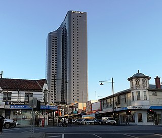
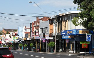
Box Hill is a suburb of Melbourne, Victoria, Australia, 14 kilometres (8.7 mi) east of the city's Central Business District (CBD), located within the City of Whitehorse local government area. Box Hill recorded a population of 14,353 at the 2021 census.

<span class="mw-page-title-main">Glen Iris, Victoria</span> Suburb of Melbourne, Victoria, Australia

Glen Iris is a suburb in Melbourne, Victoria, Australia, 10 kilometres (6.2 mi) south-east of Melbourne's Central Business District, located within the Cities of Boroondara and Stonnington local government areas. Glen Iris recorded a population of 26,131 at the 2021 census.

<span class="mw-page-title-main">Surrey Hills, Victoria</span> Suburb of Melbourne, Victoria, Australia

Surrey Hills is a suburb of Melbourne, Victoria, Australia, 11 km east of Melbourne's Central Business District, located within the Cities of Boroondara and Whitehorse local government areas. Surrey Hills recorded a population of 13,655 at the 2021 census.

<span class="mw-page-title-main">Box Hill North, Victoria</span> Suburb of Melbourne, Victoria, Australia

Box Hill North is a suburb of Melbourne, Victoria, Australia, 14 km east from Melbourne's Central Business District, located within the City of Whitehorse local government area. Box Hill North recorded a population of 12,337 at the 2021 census.

<span class="mw-page-title-main">Box Hill South, Victoria</span> Suburb of Melbourne, Victoria, Australia

Box Hill South is a suburb of Melbourne, Victoria, Australia, 14 km east of Melbourne's Central Business District, located within the City of Whitehorse local government area. Box Hill South recorded a population of 8,491 at the 2021 census.

<span class="mw-page-title-main">Burwood East, Victoria</span> Suburb of Melbourne, Victoria, Australia

Burwood East is a suburb of Melbourne, Victoria, Australia, located 17 km (11 mi) east of Melbourne's Central Business District, located within the City of Whitehorse local government area. Burwood East recorded a population of 10,675 at the 2021 census.

<span class="mw-page-title-main">Vermont South, Victoria</span> Suburb of Melbourne, Victoria, Australia

Vermont South is a suburb of Melbourne, Australia, 26 km east of its Central Business District. It had a population of 11,954 at the 2021 census.

<span class="mw-page-title-main">Ashburton, Victoria</span> Suburb of Melbourne, Victoria, Australia

Ashburton is an affluent suburb of Melbourne, Victoria, Australia, 12 km (7.5 mi) southeast of Melbourne's Central Business District, located within the City of Boroondara local government area. Ashburton recorded a population of 7,952 at the 2021 census.

Ashwood is a suburb in Melbourne, Victoria, Australia, 14 km south east of Melbourne's Central Business District, located within the City of Monash local government area. Ashwood recorded a population of 7,154 at the 2021 census.

<span class="mw-page-title-main">Melbourne tram route 75</span> Tram route in metropolitan Melbourne, Victoria, Australia

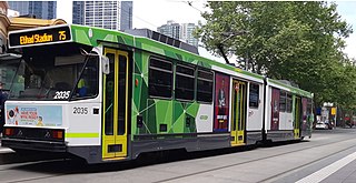
Melbourne tram route 75 is operated by Yarra Trams on the Melbourne tram network from Vermont South to Central Pier. The 22.8 kilometre route is operated out of Camberwell depot with A and B class trams. It is the longest route on the network.

<span class="mw-page-title-main">Melbourne tram route 70</span> Tram route in metropolitan Melbourne, Victoria, Australia

Melbourne tram route 70 is operated by Yarra Trams on the Melbourne tram network from Waterfront City to Wattle Park. The 16.5 kilometre route is operated out of Camberwell depot with A and B class trams.

<span class="mw-page-title-main">Wattle Park, Melbourne</span> Park in Burwood, Melbourne, Victoria, Australia

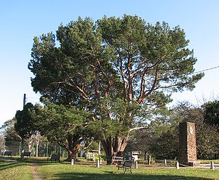
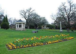
Wattle Park is a public park in Melbourne, Australia, located in the suburb of Burwood. It is known for its plantation of 12,000 wattle trees. It is currently maintained by Parks Victoria. The park provides public open space for recreation, as well as sporting facilities and a wedding and function venue.

<span class="mw-page-title-main">Waurn Ponds, Victoria</span> Suburb of Geelong, Victoria, Australia

Waurn Ponds is a mainly residential southern suburb of Geelong, Victoria, Australia.

<span class="mw-page-title-main">Gardiners Creek Trail</span>

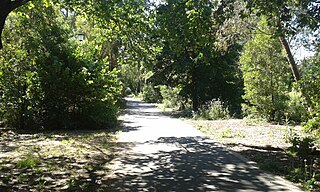
The Gardiners Creek Trail is a shared use path for cyclists and pedestrians, which follows Gardiners Creek through the eastern suburbs of Melbourne, Victoria, Australia.

<span class="mw-page-title-main">Outer Circle Trail</span>

The Outer Circle Trail, also known as the Anniversary Trail, is a shared use path for cyclists and pedestrians, which partly follows the Alamein Line through the inner eastern suburbs of Melbourne, Victoria, Australia.

The Hawthorn Tramways Trust was a tram operator in Melbourne, Australia. Its assets and liabilities were transferred to the Melbourne & Metropolitan Tramways Board on 2 February 1920.

Warrigal Road is a major inner urban road in southeastern Melbourne, Australia. On weekdays, it is heavily trafficked as it runs through many major suburbs along its route, traversing some of Melbourne's eastern and south-eastern suburbs. These suburbs include Chadstone, Oakleigh, and Cheltenham. The Chadstone Shopping Centre can be accessed directly from Warrigal Road at its eastern entrance.

<span class="mw-page-title-main">City of Box Hill</span> Local government area in Victoria, Australia

The City of Box Hill was a local government area about 15 kilometres (9 mi) east of Melbourne, the state capital of Victoria, Australia. The city covered an area of 21.50 square kilometres (8.30 sq mi), and existed from 1927 until 1994.

References

  1. Australian Bureau of Statistics (28 June 2022). "Burwood (Vic.) (suburb and locality)". Australian Census 2021 QuickStats. Retrieved 28 June 2022.  OOjs UI icon edit-ltr-progressive.svg
  2. Postcode 3125, Burwood, Victoria Postcodes Australia
  3. Australian Bureau of Statistics (28 June 2022). "Burwood (Vic.)". 2021 Census QuickStats. Retrieved 3 July 2022. OOjs UI icon edit-ltr-progressive.svg
  4. 1 2 Phoenix Auctions History. "Post Office List" . Retrieved 28 January 2021.
  5. 1 2 3 4 "Burwood and Burwood East, Victoria". Australian Places (archived). Archived from the original on 11 May 2004. Retrieved 19 May 2008.
  6. Presland G, (2007)The Whitehorse Calendar: Celebrating 150 Years of Local Government in Whitehorse, City of Whitehouse
  7. "Best Chance History". Archived from the original on 28 May 2008. Retrieved 19 May 2008.
  8. "History". Orana Family Services. Archived from the original on 18 July 2008. Retrieved 19 May 2008.
  9. "The History of the Victorian School for Deaf Children" (PDF). Deaf Children Australia. Archived from the original (PDF) on 1 September 2007. Retrieved 19 May 2008.
  10. Buckrich, Judith Raphael. "A History of the Royal Victorian Institute for the Blind 1866-2004". Australian Scholarly Publishing. Archived from the original on 21 July 2008. Retrieved 19 May 2008.
  11. 1 2 "Burwood Skyline (Hoyts)". Drive-ins Downunder – Australian Drive-ins. Archived from the original on 21 July 2008. Retrieved 20 May 2008.
  12. "Map 60". Melway. Archived from the original on 6 December 2004. Retrieved 19 May 2008.
  13. Australian Bureau of Statistics (27 June 2017). "Burwood". 2016 Census QuickStats. Retrieved 3 December 2017. OOjs UI icon edit-ltr-progressive.svg
  14. 1 2 3 4 5 "Australia Map Guide". street-directory.com.au. Retrieved 17 May 2008.
  15. "Burwood Year 9 Campus". Emmaus College. Archived from the original on 27 June 2012. Retrieved 6 October 2012.
  16. Golf Select. "Wattle Park" . Retrieved 11 May 2009.
  17. "Emmaus Animals – Club Information" . Retrieved 3 June 2020.
  18. DPS guide to aged care. http://www.agedcareguide.com.au/. Retrieved 2012-02-25
  19. "Nazeem Hussain on dabbling with napalm, Legally Brown and overt racism in Australia". www.smh.com.au. 3 April 2015. Retrieved 7 August 2019.