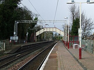
Langbank railway station serves the village of Langbank in Renfrewshire, Scotland. The station is on the Inverclyde Line, 16 miles (26 km) west of Glasgow Central.

Duirinish railway station is a remote railway station on the Kyle of Lochalsh Line near the settlement of Duirinish in the Highlands, northern Scotland. Duirinish is 2 miles (3 km) inland of Scotland's west coast, near Loch Lundie.
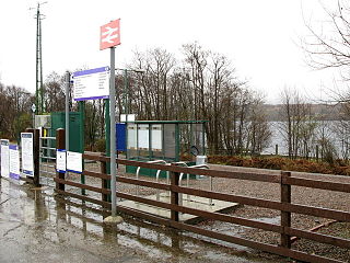
Locheilside railway station is a railway station on the northern shore of Loch Eil in the Highland Council Area of Scotland. This station is on the West Highland Line. Locheilside operates on a request stop basis.

Alexandria railway station serves the town of Alexandria, Scotland. The station is managed by ScotRail and is served by trains on the North Clyde Line, 18+3⁄4 miles (30.2 km) west of Glasgow Queen Street.

Pollokshields West railway station is one of three railway stations in Pollokshields, a district of Glasgow, Scotland. The station is managed by ScotRail and lies on the Cathcart Circle Line. The Cathcart Circle Line has been electrified since 1962 under British Railways.

Dumbreck railway station is a railway station in Dumbreck, a district of Glasgow, Scotland. The station is managed by ScotRail and lies on the Paisley Canal Line, 1¾ miles (3 km) west of Glasgow Central, close to the M77 motorway. It is accessed from the Nithsdale Road at the bridge over the railway. Dumbreck railway station is also the closest station for the Bellahouston Park.

Mosspark railway station serves the Pollok and Cardonald areas of Glasgow, Scotland. The station is on the Paisley Canal Line, 3¾ miles (6 km) west of Glasgow Central and is managed by ScotRail.

Crookston railway station is a railway station in Crookston, a district of Glasgow, Scotland. The station is managed by ScotRail and lies on the Paisley Canal Line which was reopened by British Rail, 4½ miles (7 km) west of Glasgow Central.

Hawkhead railway station is a railway station in the Seedhill area of Paisley, Renfrewshire, Scotland. The station is managed by ScotRail and lies on the Paisley Canal Line, 6½ miles (10 km) west of Glasgow Central.

Busby railway station is a railway station in the village of Busby, East Renfrewshire, Greater Glasgow, Scotland. The station is managed by ScotRail and is on the Glasgow South Western Line 7+1⁄4 miles (11.7 km) south of Glasgow Central towards East Kilbride.
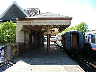
Bridge of Dun is a privately owned station in Angus. The adjacent platforms and line are independently operated as a preserved railway by the Caledonian Railway (Brechin) Ltd.
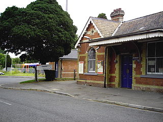
Bagshot railway station serves the village of Bagshot, in the west of Surrey, England. The station, and all trains calling there, are operated by South Western Railway. It is situated on the Ascot to Guildford line, 32 miles 8 chains (51.7 km) from London Waterloo.

Upper Greenock railway station was a railway station serving the town of Greenock, Inverclyde, Scotland, originally as part of the Greenock and Wemyss Bay Railway and later owned by the Caledonian Railway.

Bridport East Street was a railway station on the Bridport Railway in the west of the English county of Dorset. Opened on 11 March 1884, before the extension terminus at West Bay, it was just south of the level crossing on the A35 Dorchester to Honiton road, slightly nearer the centre of Bridport than the main station at Bradpole Road. Closed during the First World War and again in 1921, the station closed permanently with the West Bay extension on 22 September 1930, when the Great Western Railway gave up on hopes of creating a resort at West Bay.

Easton railway station was the terminus of the Portland Branch Railway, which operated on the Isle of Portland in the south of the English county of Dorset. The station opened with the Easton and Church Hope Railway, one of the constituent parts of a complex line, on 1 September 1902. The line past Portland station was technically a separate railway, although the branch was operated as one line throughout. Easton was closed from 11 November 1940 to 1 January 1945 following air raid damage. Although the station closed to passengers in 1952 regular freight kept the line in use until 1965. The station was demolished in the 1970s.

Ainderby railway station was a railway station serving the villages of Ainderby Steeple and Morton-on-Swale in North Yorkshire, England.
Alsager Road railway station was a station on the North Staffordshire Railway, which operated in the West Midlands county of Staffordshire, in England. The station was located on the outskirts of Alsager.

Parkmore railway station was on the Ballymena, Cushendall and Red Bay Railway which ran from Ballymena to Retreat in County Antrim, Northern Ireland.
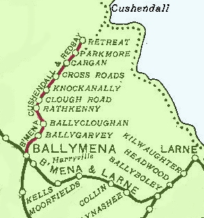
Retreat railway station was on the Ballymena, Cushendall and Red Bay Railway which ran from Ballymena to Retreat in County Antrim, Northern Ireland.

Pinkhill railway station was a railway station in Edinburgh, Scotland. It served Edinburgh Zoo, east Corstorphine and Murrayfield. Services were provided by trains on the Corstorphine Branch of the Edinburgh and Glasgow Railway.


