Russell Cave National Monument is a U.S. national monument in northeastern Alabama, United States, close to the city of Bridgeport. The monument was established on May 11, 1961, when 310 acres (1.3 km2) of land were donated by the National Geographic Society to the American people. It is now administered and maintained by the National Park Service. The national monument was listed on the National Register of Historic Places on October 15, 1966.

Etowah Indian Mounds (9BR1) are a 54-acre (220,000 m2) archaeological site in Bartow County, Georgia, south of Cartersville. Built and occupied in three phases, from 1000–1550 CE, the prehistoric site is located on the north shore of the Etowah River.

The Miami Circle, also known as The Miami River Circle, Brickell Point, or The Miami Circle at Brickell Point Site, is an archaeological site in Brickell, Miami, Florida. It consists of a perfect circle measuring 38 feet (11.5m) of 600 postmolds that contain 24 holes or basins cut into the limestone bedrock, on a coastal spit of land, surrounded by a large number of other 'minor' holes. It is the only known evidence of a prehistoric permanent structure cut into the bedrock in the Eastern United States, and considerably predates other known permanent settlements on the East Coast. It is believed to have been the location of a structure, built by the Tequesta Indians, in what was possibly their capital. Discovered in 1998, the site is believed to be somewhere between 1,700 and 2,000 years old.

Many pre-Columbian cultures in North America were collectively termed "Mound Builders", but the term has no formal meaning. It does not refer to specific people or archaeological culture but refers to the characteristic mound earthworks that indigenous peoples erected for an extended period of more than 5,000 years. The "Mound Builder" cultures span the period of roughly 3500 BCE to the 16th century CE, including the Archaic period, Woodland period, and Mississippian period. Geographically, the cultures were present in the region of the Great Lakes, the Ohio River Valley, Florida, and the Mississippi River Valley and its tributary waters.

Mogollon culture is an archaeological culture of Native American peoples from Southern New Mexico and Arizona, Northern Sonora and Chihuahua, and Western Texas. The northern part of this region is Oasisamerica, while the southern span of the Mogollon culture is known as Aridoamerica.

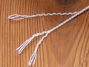
Twine is a strong thread, light string or cord composed of string two or more thinner strands twisted, and then twisted together (plied). The strands are plied in the opposite direction to that of their twist, which adds torsional strength to the cord and keeps it from unravelling. This process is sometimes called reverse wrap. The same technique used for making twine is also used to make thread, which is thinner, yarn, and rope, which is stronger and thicker, generally with three or more strands.

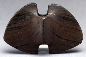
Bannerstones are artifacts usually found in the Eastern United States that are characterized by a centered hole in a symmetrically shaped carved or ground stone. The holes are typically 1⁄4" to 3⁄4" in diameter and extend through a raised portion centered in the stone. They usually are bored all the way through but some have been found with holes that extend only part of the way through. Many are made from banded slate or other colored hard stone. They often have a geometric "wing nut" or "butterfly" shape but are not limited to these. More than just functional artifacts, bannerstones are a form of art that appear in varying shapes, designs, and colors, symbolizing their ceremonial and spiritual importance.

The Modoc Rock Shelter is a rock shelter or overhang located beneath the sandstone bluffs that form the eastern border of the Mississippi River floodplain at which Native American peoples lived for thousands of years. This site is significant for its archaeological evidence of thousands of years of human habitation during the Archaic period in the Eastern United States. It is located on the northeastern side of County Road 7 southeast of Prairie du Rocher in Randolph County, Illinois, United States. It was declared a National Historic Landmark in 1961.

The Upper Mississippian cultures were located in the Upper Mississippi basin and Great Lakes region of the American Midwest. They were in existence from approximately A.D. 1000 until the Protohistoric and early Historic periods.

Prehistory of Ohio provides an overview of the activities that occurred prior to Ohio's recorded history. The ancient hunters, Paleo-Indians, descended from humans that crossed the Bering Strait. There is evidence of Paleo-Indians in Ohio, who were hunter-gatherers that ranged widely over land to hunt large game. For instance, mastodon bones were found at the Burning Tree Mastodon site that showed that it had been butchered. Clovis points have been found that indicate interaction with other groups and hunted large game. The Paleo Crossing site and Nobles Pond site provide evidence that groups interacted with one another. The Paleo-Indian's diet included fish, small game, and nuts and berries that gathered. They lived in simple shelters made of wood and bark or hides. Canoes were created by digging out trees with granite axes.

Mill Creek chert is a type of chert found in Southern Illinois and heavily exploited by members of the Mississippian culture. Artifacts made from this material are found in archaeological sites throughout the American Midwest and Southeast. It is named for a village and stream near the quarries, Mill Creek, Illinois and Mill Creek, a tributary of the Cache River. The chert was used extensively for the production of utilitarian tools such as hoes and spades, and for polished ceremonial objects such as bifaces, spatulate celts and maces.

A ceremonial pipe is a particular type of smoking pipe, used by a number of cultures of the indigenous peoples of the Americas in their sacred ceremonies. Traditionally they are used to offer prayers in a religious ceremony, to make a ceremonial commitment, or to seal a covenant or treaty. The pipe ceremony may be a component of a larger ceremony, or held as a sacred ceremony in and of itself. Indigenous peoples of the Americas who use ceremonial pipes have names for them in each culture's Indigenous language. Not all cultures have pipe traditions, and there is no single word for all ceremonial pipes across the hundreds of diverse Native American languages.

Franktown Cave is located 25 miles (40 km) south of Denver, Colorado on the north edge of the Palmer Divide. It is the largest rock shelter documented on the Palmer Divide, which contains artifacts from many prehistoric cultures. Prehistoric hunter-gatherers occupied Franktown Cave intermittently for 8,000 years beginning about 6400 BC The site held remarkable lithic and ceramic artifacts, but it is better known for its perishable artifacts, including animal hides, wood, fiber and corn. Material goods were produced for their comfort, task-simplification and religious celebration. There is evidence of the site being a campsite or dwelling as recently as AD 1725.
The Trinchera Cave Archeological District (5LA9555) is an archaeological site in Las Animas County, Colorado with artifacts primarily dating from 1000 BC to AD 1749, although there were some Archaic period artifacts found. The site was added to the National Register of Historic Places in 2001 and is located on State Trust Lands.

The following outline is provided as an overview of and topical guide to the prehistoric people of Colorado, which covers the period of when Native Americans lived in Colorado prior to contact with the Domínguez–Escalante expedition in 1776. People's lifestyles included nomadic hunter-gathering, semi-permanent village dwelling, and residing in pueblos.
Prehistoric technology is technology that predates recorded history. History is the study of the past using written records. Anything prior to the first written accounts of history is prehistoric, including earlier technologies. About 2.5 million years before writing was developed, technology began with the earliest hominids who used stone tools, which they first used to hunt food, and later to cook.

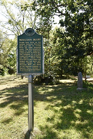
The Moccasin Bluff site is an archaeological site located along the Red Bud Trail and the St. Joseph River north of Buchanan, Michigan. It was listed on the National Register of Historic Places in 1977, and has been classified as a multi-component prehistoric site with the major component dating to the Late Woodland/Upper Mississippian period.
Humans have been present in the Canadian Maritime provinces for 10,600 years. In spite of being the first part of Canada to be settled by Europeans, research into the prehistory of the Maritimes did not become extensive until 1969. By the early 1980s, several full-time archaeologists focused on the region.
The Huber Site (11Ck-1) is located on Tinley Creek 2 miles west of Blue Island in Cook County, Illinois, near the city of Chicago. It is classified as a late prehistoric site with Upper Mississippian affiliation.
The Fisher Mound Group is a group of burial mounds with an associated village site located on the DesPlaines River near its convergence with the Kankakee River where they combine to form the Illinois River, in Will County, Illinois, about 60 miles southwest of Chicago. It is a multi-component stratified site representing several Prehistoric Upper Mississippian occupations as well as minor Late Woodland and Early Historic components.


