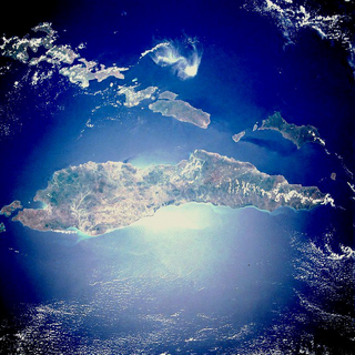
Timor is an island at the southern end of Maritime Southeast Asia, in the north of the Timor Sea. The island is divided between the sovereign states of East Timor in the eastern part and Indonesia in the western part. The Indonesian part, known as West Timor, constitutes part of the province of East Nusa Tenggara. Within West Timor lies an exclave of East Timor called Oecusse District. The island covers an area of 30,777 square kilometres. The name is a variant of timur, Malay for "east"; it is so called because it lies at the eastern end of the Lesser Sunda Islands. Mainland Australia is less than 500 km away, separated by the Timor Sea.

West Timor is an area covering the western part of the island of Timor, except for the district of Oecussi-Ambeno. Administratively, West Timor is part of East Nusa Tenggara Province, Indonesia. The capital as well as its main port is Kupang. During the colonial period, the area was named Dutch Timor and was a centre of Dutch loyalists during the Indonesian National Revolution (1945–1949). From 1949 to 1975 it was named Indonesian Timor.

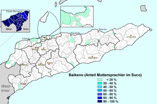
Uab Meto or Dawan is an Austronesian language spoken by Atoni people of West Timor. The language has a variant spoken in the East Timorese exclave of Oecussi-Ambeno, called Baikenu. Baikenu uses words derived from Portuguese, for example, obrigadu for 'thank you', instead of the Indonesian terima kasih.

The Bunak people are an ethnic group that live in the mountainous region of central Timor, split between the political boundary between West Timor, Indonesia, particularly in Lamaknen District and East Timor. Their language is one of those on Timor which is not an Austronesian language, but rather a Papuan language, belonging to the Trans–New Guinea linguistic family. They are surrounded by groups which speak Malayo-Polynesian languages, like the Atoni and the Tetum.

Tais is a form of Tenun weaving tradition native to the eastern Indonesian regions of the Maluku Islands, the Tanimbar Islands, the East Nusa Tenggara Islands and the independent nation of Timor Leste. It has become an essential part of people in the eastern Indonesia hemisphere region, which mainly used for ceremonial adornment, sign of respect and appreciation towards guests, friends, relatives, home decor, and personal apparel.

Amabi was a traditional principality in West Timor in the currently East Nusa Tenggara province of Indonesia. From at least the 17th century to 1917, Amabi played a role in the rivalries between the Portuguese and Dutch colonials on Timor Island.

Oecusse Airport, officially Oecusse Route of the Sandalwood International Airport, and formerly Palaban Airport, is an international airport serving Pante Macassar, the capital city of the Oecusse Special Administrative Region of East Timor.
Gaspar da Costa was the leader or tenente geral of the Portuguese-speaking Topasses, a Eurasian group that dominated much of the politics on Timor in the early modern period. He was largely responsible for the dramatic collapse of Portuguese power in West Timor, a process that laid the foundations for the modern division of Timor in an Indonesian and an independent part.

Wehali is the name of a traditional kingdom at the southern coast of Central Timor, now in Indonesia and East Timor. It is often mentioned together with its neighbouring sister kingdom, as Wewiku-Wehali (Waiwiku-Wehale). Wehali held a position of ritual seniority among the many small Timorese kingdoms.
Liurai is a ruler's title on Timor. The word is Tetun and literally means "surpassing the earth". It was originally associated with Wehali, a ritually central kingdom situated at the south coast of central Timor. The sacral lord of Wehali, the Maromak Oan enjoyed a ritually passive role, and he kept the liurai as the executive ruler of the land. In the same way, the rulers of two other important princedoms, Sonbai in West Timor and Likusaen (Liquica) in East Timor, were often referred as liurais, which indicated a symbolic tripartition of the island. In later history, especially in the nineteenth and twentieth centuries, the term liurai underwent a process of inflation. By this time it denoted any ruler in the Portuguese part of Timor, great or small. In the Dutch part in West Timor the title appears to have been restricted to the Sonbai and Wehali rulers. The rulers in the west were known by the Malay term raja, while there were internally used terms such as usif (lord) among the Dawan-speaking groups, and loro (sun) among the Tetun speakers.

Amanuban was a traditional princedom in West Timor, Indonesia. It lay in the regency (kabupaten) Timor Tengah Selatan. In the late colonial period, according to an estimate in 1930, Amanuban covered 2,075 square kilometers. The centre of the princedom since the 19th century was Niki-Niki. The population belongs to the Atoni group. Today they are predominantly Protestants, with a significant Catholic minority and some Muslims.
Sonbai Besar or Greater Sonbai was an extensive princedom of West Timor, in present-day Indonesia, which existed from 1658 to 1906 and played an important role in the history of Timor.
Sonbai Kecil or Lesser Sonbai was an Atoni princedom in West Timor, now included in Indonesia. It existed from 1658 to 1917, when it merged into a colonial creation, the zelfbesturend landschap Kupang.
Amarasi was a traditional princedom in West Timor, in present-day Indonesia. It had an important role in the political history of Timor during the 17th and 18th century, being a client state of the Portuguese colonialists, and later subjected to the Netherlands East Indies.

Oecusse, also known as Oecusse-Ambeno and formerly just Ambeno, officially the Special Administrative Region Oecusse-Ambeno, is an exclave, municipality and the only special administrative region (SAR) of East Timor.
Amarasi is a Central Malayo-Polynesian language of West Timor, and is spoken by the Amarasi. The Amarasi language has about 80,000 native speakers, with four main dialects called Ro'is, Kotos, Tais Nonof, and Ketun, though many differences exist between individual villages. Speakers are interspersed with those of Helong.

The East Timor–Indonesia border is the international border between East Timor and Indonesia. The border consists of two non-contiguous sections totalling 253 km in length, the larger section of which divides the island of Timor in two. The demarcation of the border between Indonesia and East Timor has been fought over by various parties for 350 years. The first attempts to define it precisely were made by the colonial powers of the Netherlands and Portugal with the Treaty of Lisbon in 1859, but it was not until the Permanent Court of Arbitration's award of 25 June 1914 that the final land border between them on the island of Timor was established. It largely coincides with today's border between the state of East Timor (Timor-Leste), which only gained its final independence in 2002, and West Timor, which belongs to Indonesia, but was still disputed on some points until 2019.
The Battle of Penfui took place on 9 November 1749 in the hillside of Penfui, near modern Kupang. A large Topass army was defeated by a numerically inferior Dutch East India Company force following the withdrawal of the former's Timorese allies from the battlefield, resulting in the death of the Topass leader Gaspar da Costa. Following the battle, both Topass and Portuguese influence on Timor declined, eventually leading to the formation of a boundary between Dutch and Portuguese Timor which precipitated into the modern border between West Timor and East Timor.
Batek Island or Fatu Sinai is a small island located in East Nusa Tenggara Province (NTT), Indonesia. This island located in the Savu Sea, northwest of the island of Timor, 9.3 km off the East Timorese municipality of Oecusse.

Fatuleu is a district in Kupang Regency in the Indonesian province of East Nusa Tenggara. It is located in West Timor about 40 kilometres (25 mi) northeast of the city of Kupang on the highway to Soe. It is named after the 1,108-metre-high (3,635 ft) mountain of Fatuleu, a local landmark located in the neighbouring district of Fatuleu Tengah. Its headquarters are located in the village of Camplong, formerly known as Tjamplong.


