
West Midlands is a metropolitan and ceremonial county in the larger West Midlands region of England. A landlocked county, it is bordered by Staffordshire to the north and west, Worcestershire to the south, and is surrounded by Warwickshire to the east. The largest settlement is the city of Birmingham.
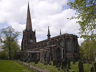
Aston is an area of inner Birmingham, in the county of the West Midlands, England. Located immediately to the north-west of Central Birmingham, Aston constitutes a ward within the metropolitan authority. It is approximately 1.5 miles (2.4 km) from Birmingham City Centre.

Rowley Regis is a town and former municipal borough in Sandwell in the county of the West Midlands, England. It forms part of the area immediately west of Birmingham known as the Black Country and encompasses the three Sandwell council wards of Blackheath, Cradley Heath and Old Hill, and Rowley. At the 2011 census, the combined population of these wards was 50,257.
South Derbyshire is a local government district in Derbyshire, England. The district covers the towns of Melbourne and Swadlincote as well as numerous villages and hamlets such as Hilton, Hatton, Etwall, Aston-on-Trent, Repton, Weston-on-Trent and Willington. About a third of the National Forest lies within the district.
The Metropolitan Borough of Solihull is a metropolitan borough in West Midlands county, England. It is named after its largest town, Solihull, from which Solihull Metropolitan Borough Council is based. For Eurostat purposes it is a NUTS 3 region and is one of seven boroughs or unitary districts that comprise the "West Midlands" NUTS 2 region. Much of the large residential population in the north of the borough centres on the communities of Castle Bromwich, Kingshurst, Marston Green and Smith's Wood as well as the towns of Chelmsley Wood and Fordbridge. In the south are the towns of Shirley and Solihull, as well as the large villages of Knowle, Dorridge, Meriden and Balsall Common.

Yardley is an area in east Birmingham, England. It is also a council constituency, managed by its own district committee. Historically it lay within Worcestershire.

Erdington is a suburb and ward of Birmingham in the West Midlands County, England. Historically part of Warwickshire, it is located 5 miles (8 km) northeast of central Birmingham, bordering Sutton Coldfield. It was also a council constituency, managed by its own district committee. The former council district consisted of the ward of Erdington as well as Tyburn, Stockland Green and Kingstanding, although all of Kingstanding and most of both Tyburn and Stockland Green wards lie outside the historical boundaries of Erdington. Stockland Green was formerly part of Aston, Kingstanding part of Perry Barr, and Tyburn partially split between Aston and Hodge Hill. Erdington (ward) was part of the Sutton Coldfield constituency before 1974.

Birmingham, a city and metropolitan borough in the West Midlands, England, is the second-largest city in the United Kingdom.

Middleton is a small village in the North Warwickshire district of the county of Warwickshire, England. The population of the civil parish at the 2011 census was 630.

East Ham was a local government district in the far south west of Essex from 1878 to 1965. It extended from Wanstead Flats in the north to the River Thames in the south and from Green Street in the west to Barking Creek in the east. It was part of the London postal district and Metropolitan Police District.

Willesden was a local government district in the county of Middlesex, England from 1874 to 1965. It formed part of the Metropolitan Police District and London postal district. Willesden was part of the built-up area of London and bordered the County of London to the east and south.
Beckenham was a local government district in north west Kent from 1878 to 1965 around the town of Beckenham. The area was suburban to London, formed part of the Metropolitan Police District and from 1933 was included in the area of the London Passenger Transport Board.

Ealing was a local government district from 1863 to 1965 around the town of Ealing which formed part of the built up area of London until 1965, where it became part of Greater London.

Southall was a local government district in the county of Middlesex, United Kingdom from 1891 to 1965. It consisted of the civil parish of Norwood.

Walthamstow was a local government district in southwest Essex, England from 1873 to 1965, around the town of Walthamstow. It was within the London suburbs, forming part of the London postal district and Metropolitan Police District. Its former area now corresponds to the central part of the London Borough of Waltham Forest in Greater London. Its population and area grew rapidly as London continued to develop its suburbs.
The following is a list of towns in England and Wales which were granted charters of incorporation conferring borough status under the Municipal Corporations Act 1882 or the Local Government Act 1933.
Birmingham Aston was a constituency of the House of Commons of the Parliament of the United Kingdom. From 1918 to 1974 it elected one Member of Parliament (MP) by the first-past-the-post system of election.

The County Borough of Leeds, and its predecessor, the Municipal Borough of Leeds, was a local government district in the West Riding of Yorkshire, England, from 1835 to 1974. Its origin was the ancient borough of Leeds, which was reformed by the Municipal Corporations Act 1835. In 1889, when West Riding County Council was formed, Leeds became a county borough outside the administrative county of the West Riding; and in 1893 the borough gained city status. The borough was extended a number of times, expanding from 21,593 acres (8,738 ha) in 1911 to 40,612 acres (16,435 ha) in 1961; adding in stages the former area of Roundhay, Seacroft, Shadwell and Middleton parishes and gaining other parts of adjacent districts. In 1971 Leeds was the fifth largest county borough by population in England. The county borough was abolished in 1974 and replaced with the larger City of Leeds, a metropolitan district of West Yorkshire.
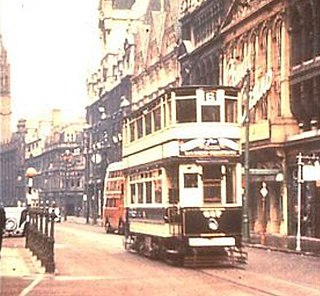
Birmingham Corporation Tramways operated a network of tramways in Birmingham from 1904 until 1953. It was the largest narrow-gauge tramway network in the UK, and was built to a gauge of 3 ft 6 in. It was the fourth largest tramway network in the UK behind London, Glasgow and Manchester.
King's Norton and Northfield Urban District was a local government administrative district in north Worcestershire, England, from 1898 until 1911. Much of its area was afterwards absorbed into the neighbouring Borough of Birmingham, under the Greater Birmingham Scheme, and now constitutes most of the city's southern and southwestern suburban environs.
