
In seismology, an earthquake swarm is a sequence of seismic events occurring in a local area within a relatively short period. The time span used to define a swarm varies, but may be days, months, or years. Such an energy release is different from the situation when a major earthquake is followed by a series of aftershocks: in earthquake swarms, no single earthquake in the sequence is obviously the main shock. In particular, a cluster of aftershocks occurring after a mainshock is not a swarm.
The 1976 Moro Gulf earthquake and tsunami occurred on near the islands of Mindanao and Sulu, in the Philippines. It measured 8.0 on the moment magnitude scale occurring at a depth of 20 km (12 mi). The earthquake was accompanied by a destructive tsunami that resulted in a majority of the estimated 5,000 to 8,000 fatalities. It was the deadliest and strongest earthquake in the Philippines in 58 years since the 1918 Celebes Sea earthquake.
The Philippine fault system is a major inter-related system of geological faults throughout the whole of the Philippine Archipelago, primarily caused by tectonic forces compressing the Philippines into what geophysicists call the Philippine Mobile Belt. Some notable Philippine faults include the Guinayangan, Masbate and Leyte faults.
The 2012 Negros earthquake occurred on February 6 at , with a body wave magnitude of 6.7 and a maximum intensity of VII (Destructive) off the coast of Negros Oriental, Philippines. The epicenter of the thrust fault earthquake was approximately 72 kilometres (45 mi) north of Negros Oriental's provincial capital, Dumaguete.
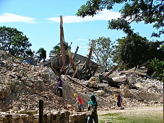
The 2013 Bohol earthquake occurred on October 15 at in Bohol, an island province located in Central Visayas, Philippines. The magnitude of the earthquake was recorded at 7.2, with epicenter 6 kilometres (3.7 mi) S 24° W of Sagbayan, and its depth of focus was 12 kilometres (7.5 mi). It affected the whole Central Visayas region, particularly Bohol and Cebu. The earthquake was felt in the whole Visayas area and as far as Masbate island in the north and Cotabato provinces in southern Mindanao.

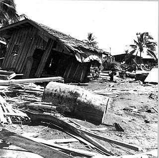
The 1918 Celebes Sea earthquake occurred on August 15 at 12:18 UTC near the Moro Gulf coast of Mindanao. It had a magnitude of 8.3 on the moment magnitude scale and a maximum perceived intensity of X (Extreme) on the Mercalli intensity scale. It triggered a tsunami of up to 7 m in height and the combined effects of the earthquake and tsunami led to the deaths of 52 people.
The 2017 Surigao earthquake occurred on February 10, 2017, at 10:03 PM (PST), with a surface-wave magnitude of 6.7 off the coast of Surigao del Norte in the Philippines. According to the PHIVOLCS earthquake intensity scale the earthquake was an Intensity VII (Destructive) earthquake at maximum. In the past Surigao province has been hit by a magnitude 7.2 tremor in both 1879 and 1893.
The 1992 Murindó earthquake occurred on October 18 at 15:11 UTC with an epicenter in the Department of Chocó, northern Colombia. The shallow magnitude 7.2 earthquake struck northwest of the town of Murindó, killing ten and injured more than a hundred. Thirty-three municipalities were severely damaged.
The 2019 Cotabato earthquakes were an earthquake swarm which struck the province of Cotabato on the island of Mindanao in the Philippines in October 2019. Three of these earthquakes were above 6.0 on the moment magnitude scale with a Mercalli intensity of VIII. More than 40 people have been reported dead or missing and nearly 800 were injured as a result of these events.
In 1954, the state of Nevada was struck by a series of earthquakes that began with three magnitude 6.0+ events in July and August that preceded the Mw 7.1–7.3 mainshock and M 6.9 aftershock, both on December 12. All five earthquakes are among the largest in the state, and the largest since the Cedar Mountain earthquake of 1932 and Pleasant Valley event in 1915. The earthquake was felt throughout much of the western United States.
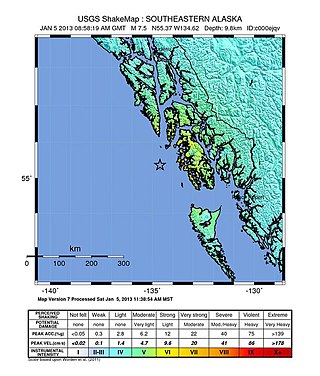
The 2013 Craig, Alaska earthquake struck on January 5, at 12:58 am (UTC–7) near the city of Craig and Hydaburg, on Prince of Wales Island. The Mw 7.5 earthquake came nearly three months after an Mw 7.8 quake struck Haida Gwaii on October 28, in 2012. The quake prompted a regional tsunami warning to British Columbia and Alaska, but it was later cancelled. Due to the remote location of the quake, there were no reports of casualties or damage.
The 1990 Bohol earthquake occurred on February 8, 1990, at 15:15:32 which had a magnitude of 6.8 Mw . The earthquake had a moderate depth of 25.9 km (16 mi). Most of the damage was observed in the province of Bohol. A tsunami hit the southeastern coastline of Bohol and the island of Camiguin. There were 6 deaths, over 200 injuries and an estimated ₱157 million in total damage reported.
On 9 July 2019, at 8:36 PM (PST), an earthquake measuring 5.6 jolted the province of North Cotabato, Davao del Sur, and other nearby provinces. The National Disaster Risk Reduction and Management Council reported one dead and three injured in Makilala after the earthquake, and a total of 164 families affected in Cotabato Province. Near the epicenter of the earthquake, the severity of strong ground motion was assigned VI (Strong) on the Modified Mercalli intensity scale. A total of 106 schools, 119 houses, and 14 other infrastructures were damaged by the earthquake.
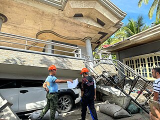
On February 7, 2021, at 12:22 PM PST, an earthquake measuring Mww 6.0 struck Davao del Sur and Cotabato. The event registered a Modified Mercalli Intensity Scale (MMI) of VIII (Severe) with VII on the PHIVOLCS Earthquake Intensity Scale (PEIS).
The 1973 Ragay Gulf earthquake occurred at around 16:30 local time. It measured 7.4 and had a maximum intensity of IX (Violent) on the Modified Mercalli intensity scale. The Philippine Institute of Volcanology and Seismology assigned a maximum intensity of VIII on the PHIVOLCS earthquake intensity scale. It killed 14 people, injured 100 others and caused an estimated $2 million in damage.
On August 12, 2021, at 01:46:12 PST, a strong Mw 7.1 earthquake struck the island of Mindanao at a depth of 55.1 kilometers (34.2 mi). It had a maximum perceived Intensity V on the PHIVOLCS Earthquake Intensity Scale. No damage or injuries were reported but a young man was killed by the earthquake.
The 1955 Lanao earthquake struck Lanao del Sur on April 1 at 02:17 local time. The earthquake measuring 7.4 on the moment magnitude scale and assigned a maximum intensity of VIII (Severe) on the Modified Mercalli intensity scale was one of the largest to hit Mindanao. It caused immense damage around the northern and central parts of Mindanao, as well as the southern reaches of Visayas. It killed at least 465 individuals and injured a further 898.
At 16:14 PST on November 17, 2023, the province of Sarangani on the island of Mindanao in the Philippines was struck by an earthquake measuring 6.7 . It had a maximum perceived intensity of VIII (Severe) on the Modified Mercalli Intensity Scale. At least eleven people were killed and another 730 were treated for injuries.

On December 2, 2023, at 22:37 PST, a moment magnitude (Mww ) 7.6 earthquake occurred off the island of Mindanao in the Philippines. The shallow subduction earthquake killed at least three people and left 79 injured.


