US8498808B2 - Method and apparatus for hybrid routing using breadcrumb paths - Google Patents
Method and apparatus for hybrid routing using breadcrumb paths Download PDFInfo
- Publication number
- US8498808B2 US8498808B2 US12/016,949 US1694908A US8498808B2 US 8498808 B2 US8498808 B2 US 8498808B2 US 1694908 A US1694908 A US 1694908A US 8498808 B2 US8498808 B2 US 8498808B2
- Authority
- US
- United States
- Prior art keywords
- route
- location
- positioning device
- point
- map
- Prior art date
- Legal status (The legal status is an assumption and is not a legal conclusion. Google has not performed a legal analysis and makes no representation as to the accuracy of the status listed.)
- Active, expires
Links
- 238000000034 method Methods 0.000 title claims abstract description 131
- 235000012813 breadcrumbs Nutrition 0.000 title description 28
- 230000000153 supplemental effect Effects 0.000 claims 5
- 230000008569 process Effects 0.000 description 88
- 230000015654 memory Effects 0.000 description 7
- 230000005540 biological transmission Effects 0.000 description 5
- 238000013507 mapping Methods 0.000 description 4
- 238000003825 pressing Methods 0.000 description 4
- 230000004044 response Effects 0.000 description 4
- 230000000007 visual effect Effects 0.000 description 4
- 238000013459 approach Methods 0.000 description 2
- 230000006870 function Effects 0.000 description 2
- 238000012986 modification Methods 0.000 description 2
- 230000004048 modification Effects 0.000 description 2
- 230000003287 optical effect Effects 0.000 description 2
- 238000012545 processing Methods 0.000 description 2
- 230000007704 transition Effects 0.000 description 2
- 238000004891 communication Methods 0.000 description 1
- 238000013461 design Methods 0.000 description 1
- 230000000694 effects Effects 0.000 description 1
- 230000007274 generation of a signal involved in cell-cell signaling Effects 0.000 description 1
- 230000005291 magnetic effect Effects 0.000 description 1
- 238000012544 monitoring process Methods 0.000 description 1
- 230000009467 reduction Effects 0.000 description 1
- 238000010187 selection method Methods 0.000 description 1
- 230000001960 triggered effect Effects 0.000 description 1
Images


Classifications
-
- G—PHYSICS
- G01—MEASURING; TESTING
- G01C—MEASURING DISTANCES, LEVELS OR BEARINGS; SURVEYING; NAVIGATION; GYROSCOPIC INSTRUMENTS; PHOTOGRAMMETRY OR VIDEOGRAMMETRY
- G01C21/00—Navigation; Navigational instruments not provided for in groups G01C1/00 - G01C19/00
- G01C21/26—Navigation; Navigational instruments not provided for in groups G01C1/00 - G01C19/00 specially adapted for navigation in a road network
- G01C21/34—Route searching; Route guidance
-
- G—PHYSICS
- G01—MEASURING; TESTING
- G01C—MEASURING DISTANCES, LEVELS OR BEARINGS; SURVEYING; NAVIGATION; GYROSCOPIC INSTRUMENTS; PHOTOGRAMMETRY OR VIDEOGRAMMETRY
- G01C21/00—Navigation; Navigational instruments not provided for in groups G01C1/00 - G01C19/00
- G01C21/20—Instruments for performing navigational calculations
-
- G—PHYSICS
- G01—MEASURING; TESTING
- G01C—MEASURING DISTANCES, LEVELS OR BEARINGS; SURVEYING; NAVIGATION; GYROSCOPIC INSTRUMENTS; PHOTOGRAMMETRY OR VIDEOGRAMMETRY
- G01C21/00—Navigation; Navigational instruments not provided for in groups G01C1/00 - G01C19/00
- G01C21/26—Navigation; Navigational instruments not provided for in groups G01C1/00 - G01C19/00 specially adapted for navigation in a road network
- G01C21/34—Route searching; Route guidance
- G01C21/36—Input/output arrangements for on-board computers
- G01C21/3679—Retrieval, searching and output of POI information, e.g. hotels, restaurants, shops, filling stations, parking facilities
- G01C21/3685—Retrieval, searching and output of POI information, e.g. hotels, restaurants, shops, filling stations, parking facilities the POI's being parking facilities
-
- G—PHYSICS
- G08—SIGNALLING
- G08G—TRAFFIC CONTROL SYSTEMS
- G08G1/00—Traffic control systems for road vehicles
- G08G1/005—Traffic control systems for road vehicles including pedestrian guidance indicator
-
- G—PHYSICS
- G08—SIGNALLING
- G08G—TRAFFIC CONTROL SYSTEMS
- G08G1/00—Traffic control systems for road vehicles
- G08G1/14—Traffic control systems for road vehicles indicating individual free spaces in parking areas
- G08G1/141—Traffic control systems for road vehicles indicating individual free spaces in parking areas with means giving the indication of available parking spaces
- G08G1/143—Traffic control systems for road vehicles indicating individual free spaces in parking areas with means giving the indication of available parking spaces inside the vehicles
-
- G—PHYSICS
- G08—SIGNALLING
- G08G—TRAFFIC CONTROL SYSTEMS
- G08G1/00—Traffic control systems for road vehicles
- G08G1/14—Traffic control systems for road vehicles indicating individual free spaces in parking areas
- G08G1/141—Traffic control systems for road vehicles indicating individual free spaces in parking areas with means giving the indication of available parking spaces
- G08G1/144—Traffic control systems for road vehicles indicating individual free spaces in parking areas with means giving the indication of available parking spaces on portable or mobile units, e.g. personal digital assistant [PDA]
-
- G—PHYSICS
- G08—SIGNALLING
- G08G—TRAFFIC CONTROL SYSTEMS
- G08G1/00—Traffic control systems for road vehicles
- G08G1/14—Traffic control systems for road vehicles indicating individual free spaces in parking areas
- G08G1/145—Traffic control systems for road vehicles indicating individual free spaces in parking areas where the indication depends on the parking areas
- G08G1/146—Traffic control systems for road vehicles indicating individual free spaces in parking areas where the indication depends on the parking areas where the parking area is a limited parking space, e.g. parking garage, restricted space
-
- G—PHYSICS
- G08—SIGNALLING
- G08G—TRAFFIC CONTROL SYSTEMS
- G08G1/00—Traffic control systems for road vehicles
- G08G1/14—Traffic control systems for road vehicles indicating individual free spaces in parking areas
- G08G1/145—Traffic control systems for road vehicles indicating individual free spaces in parking areas where the indication depends on the parking areas
- G08G1/147—Traffic control systems for road vehicles indicating individual free spaces in parking areas where the indication depends on the parking areas where the parking area is within an open public zone, e.g. city centre
-
- G—PHYSICS
- G08—SIGNALLING
- G08G—TRAFFIC CONTROL SYSTEMS
- G08G1/00—Traffic control systems for road vehicles
- G08G1/20—Monitoring the location of vehicles belonging to a group, e.g. fleet of vehicles, countable or determined number of vehicles
- G08G1/205—Indicating the location of the monitored vehicles as destination, e.g. accidents, stolen, rental
Definitions
- This invention relates generally to the field of a positioning devices. More particularly, the invention relates to a method and apparatus for mapping and routing using a positioning device.
- Positioning devices such as global positioning systems, are used in a variety of applications. Positioning device can be used to generate point-to-point routes from a current location to a selected destination on a digital map and provide real-time directions to get to the selected destination.
- a method and apparatus for routing using a positioning device and a map having a plurality of segments generating a first route from a first location to a second location; generating signals to provide directions along the first route using positioning information from the positioning device; detecting that the positioning device is off-route at a third location, the third location being adjacent to the first route; generating a second route by tracking the position of the positioning device from the third location to to a fourth location, and, in some cases, storing the second route for use in route generation.
- FIG. 1 is a flow chart illustrating a method of searching for parking according to one embodiment of the invention.
- FIG. 2 is a flow chart illustrating a method of pedestrian routing according to one embodiment of the invention.
- FIG. 3 is a flow chart illustrating a method of routing using alternative access points to venues according to one embodiment of the invention.
- FIG. 4 is a diagrammatic representation of a map with a search for parking using a spiral pattern route according to one embodiment of the invention.
- FIG. 5 is a diagrammatic representation of a map with a search for parking using a zig-zag pattern route according to one embodiment of the invention.
- FIG. 6 is a diagrammatic representation of a map with a search for parking using a grid pattern route according to one embodiment of the invention.
- FIG. 7 is a diagrammatic representation of a map with a pedestrian route according to one embodiment of the invention.
- FIG. 8 is a diagrammatic representation of a map with a pedestrian route according to one embodiment of the invention.
- FIG. 9 is a diagrammatic representation of a map with a pedestrian route according to one embodiment of the invention.
- FIG. 10 is a diagrammatic representation of a map with a pedestrian route according to one embodiment of the invention.
- FIG. 11 is a diagrammatic representation of a map with a vehicle route according to one embodiment of the invention.
- FIG. 12 is a diagrammatic representation of a map with alternative routes according to one embodiment of the invention.
- FIG. 13 is a diagrammatic representation of a machine in the exemplary form of a computer system.
- At least some embodiments of the disclosure relate to a method and system for routing using a positioning device.
- Positioning devices can determine the location of the positioning device using various methods and apparatus, such as global positioning systems (GPS), long-range navigation (LORAN) systems, and triangulation methods using cell phone base station transmissions or Wi-Fi (IEEE 802.11) transmissions from known locations.
- GPS global positioning systems
- LORAN long-range navigation
- Wi-Fi IEEE 802.11
- a digital map can include a network of segments representing paths that can be taken to get from one location to another.
- the map can include information such as associations between street addresses and locations so that a user can specify a location by street address.
- the map can also contain locations of point of interests such as parks, airports, and landmarks so that a user can specify a location on the map by point of interest.
- a map may contain other information such as locations of restaurants, entertainment venues, gas stations as well as related information so that a user may select one of these venues on the map by selecting one of the venues that meets the venue classification and/or other criteria such as restaurant cuisine or entertainment type desired.
- Segment is used herein in some instances to describe a physical path that a vehicle or person can traverse, the physical path as represented in a map, or both.
- a positioning device using a map can perform useful mapping and routing functions.
- a positioning device can determine the location on the map of a pedestrian carrying the positioning device or the location of a vehicle carrying the positioning device.
- the positioning device can use a map to route a user from the current location to a destination point on the map selected by street address, point of interest, or a criteria-based selection method, for example.
- the positioning device can generate a “best” route from a starting point to a destination point on the map.
- Each segment may have an associated length which is used by the routing system determine the combination of segments (route) on the map with the shortest distance between the two points.
- Each segment may also have an associated travel time which can be used to determine the route with the shortest projected travel time between the two points.
- Other criteria and methods for selecting a best route may be used.
- the “best” route selected may not actually be better than all other routes. For example, limitations in the selection algorithm, computation time allocated to the route selection process, errors in the associated segment lengths and projected travel times, and differing user-preferences, may cause less than optimal routes to be selected.
- the “best” route selected is a satisfactory route to the selected destination that is significantly inferior to alternative routes based on the selected criteria.
- a “good enough” route is used instead of a “best” route.
- FIG. 1 illustrates a flow chart of a search-for-parking method according to one embodiment of the present invention.
- a search for parking mode is initiated.
- a search-for-parking mode may be initiated automatically when the positioning device detects that the vehicle moves past the destination location of a route generated using point-to-point routing, for example. When the user drives past the destination, it is assumed they are now looking for a nearby parking spot.
- Search-for-parking mode may also be user-initiated by a voice-activated command or touch-screen input, for example.
- a destination location is selected.
- the destination location may be selected as part of a point-to-point routing process. For example, a route may be generated from a current location to a destination location and a search-for-parking process may be automatically initiated as the driver approaches or drives past the destination location.
- a destination location may be identified when the user is at a location they would like to visit and wants to look for parking in the vicinity of that location. For example, the user may drive past a destination and see that there are no parking spots within their immediate view and initiate the search-for-parking process indicating that the current location of the vehicle should be selected as the destination location.
- the destination location is a reference point used in the search-for-parking process. For example, the search-for-parking route is generated to find a parking spot near the destination location and the destination location is used to route a user back to the destination after they have parked the vehicle.
- a search-for-parking route is generated by prioritizing the segments in the map that are close to the destination location and avoiding traversing the same segments more than once.
- “close” can be defined by the user, predetermined by design or determined based on conditions.
- the distance from a segment to the destination may be calculated in many ways, such as by computing the distance from the midpoint of the segment to the destination. In some cases, a previously traversed segment without any available parking spots is less likely to have an available parking spot during a second pass than a segment that has not yet been traversed.
- routes that can be used that are generally consistent with the search-for-parking priorities disclosed herein are a spiral route, a zig-zag route and a grid route.
- the route patterns are discussed in further detail herein.
- the search-for-parking priorities are affected by the routing rules and the map information. For example, segments in the map may not follow regular patterns and limit the ability to route according to idealized versions of the exemplary patterns mentioned above. Furthermore, routing limitations like one-way streets and turning restrictions may also limit routing according to the idealized patterns. In some search-for-parking routes, segments further from the destination are traversed before segments that are closer to the destination and the same segment is traversed more than once in order to balance the search-for-parking priorities with other routing rules and priorities. As a result of practical limitations, routes may be generated according to less idealized patterns but still within the spirit and scope of the present invention.
- the search-for-parking route is an open-ended route that is extended as the user approaches the end of the search-for-parking route.
- the search for parking route is generated up to a predetermined distance from the destination and the search-for-parking process is restarted automatically if the vehicle arrives at the end of the search-for a-parking route.
- restarting the search-for-parking process results in generating and following a restart route directly back to the destination and restarting the search-for-parking route from the beginning.
- another search-for-parking route is generated for the second or subsequent restarts of the search-for-parking process. For example, segments not traversed in the previous search-for-parking route may be prioritized for subsequent search-for-parking routes.
- the user is guided along the search-for-parking route.
- the user may be guided using speech synthesized voice announcements, a visual display, audio tones, and/or other methods of communicating directions along the search-for-parking route.
- a driver is told when to make turns, enter or exit highways, and given other real-time directions to guide a driver to keep the vehicle on the search-for-parking route.
- process 120 it is determined when the vehicle is parked.
- the positioning device determines the vehicle is parked when the vehicle engine is shut off.
- a wired or wireless connection between circuitry monitoring the status of the engine and the positioning device may be used to communicate the status of the engine to the positioning device.
- the positioning device sits in a cradle in the vehicle.
- the cradle may include connections to receive information as to whether the vehicle engine is on or off and otherwise transmit and receive information between the positioning device and the vehicle.
- the removable positioning device interfaces through the cradle with a fixed positioning device embedded in the vehicle dashboard, for example.
- the removable positioning device is configured to perform pedestrian routing and the fixed positioning device is configured to perform vehicle routing.
- the removable positioning device transmits information to the fixed positioning device when the removable positioning device is returned to the cradle.
- the information may include the location of alternate entrances, breadcrumb routes and parking lots identified since the removable positioning device was last removed from the cradle.
- the removable positioning device automatically transmits the information to the fixed positioning device using wireless transmission methods when the removable positioning device is within range to wirelessly transmit to the fixed positioning device. Other methods of periodically synchronizing the information between the two positioning devices may be used.
- the positioning device may automatically determine that the vehicle is parked when the positioning device is removed from the cradle in the vehicle. For example, the user may remove the positioning device from the cradle to take with them and use in a pedestrian mode after leaving the parked vehicle.
- the user may indicate that the vehicle is parked.
- the user may press a touch-screen input that indicates the vehicle is parked or speak one or more words recognized by a voice recognition system to indicate that the vehicle is parked.
- this input is received directly by the positioning device.
- the input is received by a device external to the positioning device and communicated to the positioning device through a wired or wireless connection.
- process 125 is performed. If the vehicle is not parked, process 140 is performed.
- the positioning device determines that the vehicle is parked on the curbside or otherwise along the side of the search-for-parking route since the vehicle was on the search-for-parking route when the positioning device determined that the vehicle was parked.
- the positioning device marks the location of the parked vehicle.
- the location of the parked vehicle is used to route a user back to the parked vehicle at a later time.
- the positioning device enters pedestrian mode.
- the positioning device enters pedestrian mode automatically when the positioning device determines that the vehicle is parked according to the methods described with reference to process 120 .
- the positioning device may automatically enter pedestrian mode when removed from the cradle in the vehicle.
- the positioning device may automatically enter vehicle mode when placed in the cradle in the vehicle.
- the positioning device in pedestrian mode is configured to behave differently than the positioning device in vehicle mode. For example, certain segments in the map may only be available for routing in pedestrian mode (they are not traversable by vehicle) and other segments may only be available for routing in vehicle mode (they are not traversable by pedestrians). The method is completed.
- process 140 it is determined whether the vehicle is on the search-for-parking route. If the vehicle is on the search-for-parking route, process 115 is performed. If the vehicle is not on the search-for-parking route, process 145 is performed.
- process 145 it is determined whether the vehicle is on another segment in the map that is not on the search-for-parking route. If the vehicle is on another segment in the map, process 150 is performed. If the vehicle is not on another segment on the map, process 155 is performed.
- the vehicle is on another segment of the map that diverges from the search-for-parking route.
- the positioning device assumes that a wrong turn was made and makes an announcement notifying the user.
- the positioning device generates a new search-for-parking route from the current location according to the search-for-parking priorities described herein with the same destination point as the reference point. Process 115 is performed.
- the vehicle is not on another segment of the map.
- the positioning device is considered “off-map” because it is not located on a segment of the map.
- the positioning device assumes that the vehicle has turned into the entrance of a parking lot.
- the positioning device stores the current location as the location of an entrance to the parking lot.
- the actual entrance of the parking lot may be some distance from the location at which the positioning device determined that the vehicle was “off-route” but this location is sufficiently close for the purposes of routing to and from the entrance of the parking lot.
- the positioning device periodically determines the location of the positioning device and plots the sequence of points on the map.
- a sequence of points generated in this way is known as a breadcrumb route.
- This breadcrumb route tracks the path taken by the vehicle in the parking lot.
- the breadcrumb route is stored in the positioning device.
- process 165 it is determined when the vehicle is parked.
- the positioning device determines the vehicle is parked when the vehicle engine is shut off. In another embodiment, the positioning device may automatically determine that the vehicle is parked when the positioning device is removed from a cradle in the vehicle. For example, the user may remove the positioning device from the cradle to take with them and use in a pedestrian mode after leaving the parked vehicle. In yet another embodiment, the user may indicate that the vehicle is parked.
- process 170 is performed. If the vehicle is not parked, process 160 is performed.
- the positioning device determines that the vehicle is parked in the parking lot since the vehicle went off-route into a parking lot at process 155 .
- Process 130 is performed.
- FIG. 2 illustrates a flow chart of a pedestrian routing method according to one embodiment of the present invention.
- the positioning device enters pedestrian mode.
- the positioning device may automatically enter pedestrian mode when removed from a cradle in the vehicle.
- Pedestrian mode may also be user-initiated by a voice-activated command or touch-screen input, for example.
- the positioning device always operates in a mode for pedestrian routing.
- instructions and/or data is downloaded by a portable positioning device from the positioning device in the vehicle so that the portable positioning device may be used according to the method described in this flow chart.
- Process 205 is performed.
- a destination is selected.
- the destination may be the destination referenced in the search-for-parking process.
- the user completes the search-for-parking process of FIG. 1 and requests the positioning device to generate a route to walk from the parked car to the destination.
- the route from the parked car to the destination is automatically generated when the user removes the positioning device from the cradle of the parked vehicle
- another destination is selected by specifying a street address, a point-of-interest or a location by other selection means.
- a pedestrian route is generated to the destination.
- the pedestrian route includes a breadcrumb route generated from the entrance of the parking lot along the path the vehicle took to the point at which the vehicle is parked. The user is expected to follow that breadcrumb route back to the entrance of the parking lot. At that point, the user is at or near a segment of the map because that is where the vehicle went off-route. Point-to-point routing is used from the access point of the parking lot to the destination selected in the process 205 .
- the user is guided along the pedestrian route using speech synthesized voice announcements, a visual display, audio tones, and/or other methods of communicating directions along the search-for-parking route.
- the user may be told when to make turns and given other real-time directions to keep them on the pedestrian route.
- the user is guided using the pedestrian route illustrated in a map display or guided using text directions.
- process 220 it is determined whether the user is on the pedestrian route. If the user is on the pedestrian route, process 215 is performed. If the user is not on the pedestrian route, process 225 is performed.
- process 225 it is determined whether the user is on another segment of the map. If the user is on another segment of the map, process 230 is performed. If the user is not on another segment of the map, process 235 is performed.
- the vehicle is on another segment of the map that diverges from the pedestrian route.
- the positioning device determines that a wrong turn was made and makes an announcement notifying the user.
- the positioning device generates a new pedestrian route from the current location.
- the positioning device may wait for a given time period or for a given distance of divergence from the pedestrian path, before generating a new pedestrian route. This gives the user an opportunity to correct course back to the pedestrian route if the divergence was unintended.
- Process 215 is performed.
- process 235 it is determined whether the user is at the destination. The user has diverged from the pedestrian route but is not on another segment of the map. The user is considered “off-map” because the user is not located on a segment of the map. If the user is at the destination, process 270 is performed. If the user is not at the destination, process 240 is performed.
- the positioning device determines that the user is taking a shortcut that is not represented as a segment in the map.
- a breadcrumb route is stored until the user arrives at another segment or at the destination.
- the positioning device determines that the user is at the destination.
- the breadcrumb route is a route from the location at which the user went off-route to the location of the destination.
- Process 255 is performed.
- the positioning device determines that the user is at another segment of the map.
- the breadcrumb route is a route from the location at which the user went off-route to the segment of the current location of the user.
- Process 260 is performed.
- the breadcrumb route is stored as a new segment ending at an entrance to the venue.
- the new segment runs from the location that the user went off-route to the destination.
- this new segment is made available for generation of all routes.
- this new segment is available only to generate routes in pedestrian mode.
- this new segment is made available to generate routes in modes as specified by the user. For example, when the breadcrumb route is stored as a segment, the user may be prompted to indicate whether this new segment should also be made available for vehicle mode.
- Process 275 is performed.
- the breadcrumb route is stored as a new segment running from the location that the positioning device went off-route to the location that the positioning device arrived at a segment of the map.
- the positioning device stores the segment.
- this new segment is made available for generation of all routes.
- this new segment is available only to generate routes in pedestrian mode.
- this new segment is made available to generate routes in modes as specified by the user. For example, when the breadcrumb route is stored as a segment, the user may be prompted to indicate whether this new segment should also be made available for vehicle mode.
- process 265 new directions are generated using point-to-point routing from the point at which the positioning device returns to a segment of the map to the destination.
- Process 215 is performed.
- the location is stored as an entrance to the venue.
- the positioning device determines that the user has turned into an alternative entrance to a venue.
- the positioning device stores the current location as the location of an entrance to the venue.
- the actual entrance of the venue may be some distance from the location at which positioning device determined that the user was “off-route” but this location is sufficiently close for the purposes of routing to and from the entrance of the venue.
- the positioning device determines whether it is at the parking lot where the vehicle was parked. If the positioning device is at that parking lot, process 280 is performed. If the positioning device is not at that parking lot, the method is completed.
- a route is generated to the parked vehicle through the parking lot using the previously stored breadcrumb path.
- the parking lot breadcrumb path is generated in process 160 shown in FIG. 1 .
- the parking lot breadcrumb path represents the path the vehicle took from a parking lot entrance to the location that the vehicle is parked.
- the route is generated from the parking lot entrance to the closest point on the parking lot breadcrumb path.
- the user uses the route to get to the parking lot breadcrumb path and then takes the portion of the parking lot breadcrumb path that leads to the parked vehicle.
- the user is at the same parking lot entrance at which the parking lot breadcrumb path begins, no route is generated and the parking lot breadcrumb path is used in its entirety.
- the user is guided to the parked vehicle using speech synthesized voice announcements, a visual display, audio tones, and/or other methods of communicating directions along the search-for-parking route.
- the user may be told when to make turns and given other real-time directions to keep them on the pedestrian route.
- the user is guided using the pedestrian route illustrated in a map display or guided using text directions. The method is completed.
- FIG. 3 illustrates a flow chart of a routing method according to one embodiment of the present invention.
- the positioning device identifies access points at the current location of the positioning device.
- the venue only has an access point corresponding to the main entrance associated with the address of the venue, for example.
- one or more additional access points have been stored for this venue according to the methods described herein.
- the current location is on a segment of the map and this location is the used as the only starting location. Process 305 is performed.
- the positioning device identifies access points at the destination location.
- the destination only has an access point corresponding to the main entrance associated with the address of the destination, for example.
- one or more additional access points have been stored for the destination according to the methods described herein.
- the destination is on a segment of the map and this location is the used as the only destination location. Process 310 is performed.
- some access points may be stored as an entrance, exit, or both. In such cases, only exits are used at the current location and only entrances are used at the destination.
- the positioning device determines whether to enable or disable additional shortcut segments for routing.
- Shortcut segments are breadcrumb routes stored according to methods described herein.
- the shortcut segments are made available for generation of all routes.
- the shortcut segments are available only to generate routes in pedestrian mode.
- shortcut segments are made available to generate routes in modes as specified by the user. For example, when a breadcrumb route is stored as a shortcut segment, the user may be prompted to indicate whether the new shortcut segment should also be made available for vehicle mode.
- Process 315 is performed.
- a set of alternative routes are generated between the current location and the destination using all combinations of access points for each location with or without the shortcut segments, depending on whether shortcut segments are enabled. For example, if the current location has two access points and the destination has two access points, four alternative routes would be generated: (1) a route from the first access point of the current location to the first access point of the destination; (2) a route from the first access point of the current location to the second access point of the destination; (3) a route from the second access point of the current location to the first access point of the destination; and (4) a route from the second access point of the current location to the second access point of the destination.
- Process 320 is performed.
- the best route is selected among the alternative routes.
- the best route may be the route with the shortest length or the shortest projected travel time, for example. In some cases, the best route is not the optimal route but one of the best routes.
- Process 325 is performed.
- process 325 the user is guided along the best route to the destination. The method is completed.
- FIG. 4 illustrates a diagrammatic representation of a map with routing information according to one embodiment of the present invention.
- a vehicle starts off at a point 400 .
- point-to-point routing is used to generate a route to drive the car to a selected location using the segments in the map.
- a user enters an address of a venue 460 or otherwise specifies a destination point into a positioning device.
- the positioning device generates a route 410 to a point 401 .
- the point 401 is the destination point associated in the map with the address of the venue 460 .
- the point 401 is in the vicinity of an access point 440 of the venue 460 .
- An access point can be an entrance, exit or both an entrance and an exit to the venue.
- the access point may take many forms, such as a door, a corridor, a stairway, an opening in a wall or any other means for entry or exit.
- the venue can be a building, shopping complex, university campus, park, parking lot or other places that have access points for entry or exit.
- the point 401 is associated with a place without any access points, such as an open field.
- the positioning system while responding to the initial routing request or after arriving at the point 401 , the positioning system checks for parking lots in the vicinity of the point 401 using the map. If a parking lot is found that the user considers acceptably close to the point 401 , the positioning system may be used to route to that parking lot location using point-to-point routing from the point 400 or from the point 401 , for example.
- the map does not include existing nearby parking lots (“unmapped parking lots”).
- the only available parking spots are curbside parking spots which are not included in the map. Therefore, there may be a closer parking lot or closer parking spots not represented in the map. The user may opt to search for parking instead of being routed to the closest parking lot in the map.
- the user triggers a search-for-parking mode by speaking a command recognized by a voice-recognition system or pressing a button on the positioning device.
- the positioning system In the search-for-parking mode, the positioning system generates a route starting at the current location of the vehicle at or near the point 101 , for example, selecting segments on the map by prioritizing segments closer to the point 101 and avoiding use of the same segments more than once (“search-for-parking priorities”).
- search-for-parking priorities By selecting segments with the search-for-parking priorities, the driver checks for curbside parking and unmapped parking lots in locations that are closer to the point 101 thereby attempting to minimize the walk from the parking spot to the destination.
- selecting segments with search-for-parking priorities the user avoids checking the same locations a second time when other nearby locations have yet to be checked.
- a route 411 is generated to search for parking.
- the route 411 is in a spiral pattern around the venue 460 .
- the route 411 generally follows the search-for-parking priorities by prioritizing the closest segments to the point 401 while avoiding traversing the same segments twice.
- the positioning device tracks the vehicle's position along segments of the route 411 .
- the positioning device may respond as if the user made a wrong turn and generate an announcement notifying the user of the mistake and generate a point-to-point route to get the vehicle back onto the route 411 .
- the user may have intentionally left the route 411 because based on their view from the vehicle they believe that parking is more likely on the alternative path that they took.
- the positioning device may generate a new search-for-parking route given the turn off of the route 411 since the route 411 is not for the purpose of arriving at any particular destination.
- the user may find curbside parking. For example, the user may find parking at a point 403 on the route 411 .
- the positioning system may determine that the vehicle is parked when the vehicle engine is shut off. In another embodiment, the positioning system determines that the vehicle is parked when the positioning device is removed from a cradle in the vehicle. The user may remove the positioning device to carry with them for pedestrian mapping and routing. In some embodiments, the user may indicate that the vehicle is parked by speaking a command recognized by a voice-recognition system or pressing a button on the positioning device. When the positioning device determines that the vehicle is parked, it stores that location for future reference. The user can then take the positioning device with them when they leave the vehicle and request routing directions back to the parked vehicle at a later time.
- the user may find a parking lot while driving along the route 411 .
- the positioning device determines that this location is an access point to a parking lot. For example, a vehicle on the route 411 turns onto an off-route 420 and in response the positioning device marks an access point 443 to a parking lot 463 .
- the first lot access point 443 can be stored in the map to be used for future routing requests. For example, after the access point 443 is stored in the map, the positioning device can be configured to return this location as a parking option when local parking lots are requested. Furthermore, point-to-point routing can be performed to the access point 443 . For example, the next time the user is at the point 400 and is interested in going to the venue 460 , point-to-point routing from the point 400 to the access point 443 can be performed, routing the vehicle (or pedestrian) directly to the nearby parking lot. Alternatively, the next time the user is at the point 401 , point-to-point routing from the point 401 to the access point 443 can be performed, routing the vehicle directly to the nearby parking lot.
- the access point may only be an entrance to the parking lot or it may be both an entrance and an exit to the parking lot.
- user input is requested to classify this access point as an entrance only, an exit only, or both and entrance and exit and this information is used for future routing requests. For example, when point-to-point routing is performed to the parking lot 463 , the positioning device prioritizes access points classified as entrances to the parking lot 463 . When point-to-point routing is performed starting at a location within the parking lot 463 , access points classified as exits from the parking lot 463 are prioritized.
- the positioning device can store a route by periodically determining the location of the vehicle and plotting the path in the map, also known as a breadcrumb route.
- the route 418 is the breadcrumb route from the off-route 420 to a point 402 .
- the point 402 is where the car is parked in the parking lot 463 .
- the positioning device determines that the car is parked when the engine is turned off.
- the positioning device then enters a pedestrian mode in response to the vehicle being removed from a cradle in the vehicle.
- the positioning device is configured for pedestrian use when it is in pedestrian mode.
- the search-for-parking routes are open ended and continues to direct the user further and further away from the point 401 in search of parking by selecting segments according to the search-for-parking priorities.
- the positioning system displays or periodically announces the current distance from the point 401 so that the user can decide whether to restart the search-for-parking process.
- the user triggers a restart of the search-for-parking process by speaking a command recognized by a voice-recognition system or pressing a button on the positioning device.
- a restart is triggered when the distance from the destination exceeds a predetermined threshold.
- the positioning device may be configured to restart when the user is more than a half mile from the destination.
- a restart is requested in search-for-parking mode, a point-to-point route from the current location of the vehicle to the point 401 is generated and real-time directions are announced to the user to direct the vehicle back to the point 401 where the search-for-parking process is restarted.
- the a restart may be automatically or manually generated.
- a route 420 is generated from the point 404 to the point 401 and the user is guided to follow the route 420 .
- the search for parking continues.
- the search-for-parking route used in the previous search is used again.
- alternative search-for-parking routes may be used.
- the search-for-parking process may be restarted more than once.
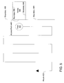
- FIG. 5 illustrates a diagrammatic representation of a map with a zig-zag pattern according to one embodiment of the present invention.
- a user is routed to a point 501 at the access point 540 of a venue 560 .
- a boundary 590 may extend in either direction preventing the use of a spiral pattern, for example, around the venue 560 .
- the zig-zag pattern is selected at least in part because the pattern and routing rules of the segments in the vicinity of the venue 560 can be more efficiently used consistent with a zig-zag pattern as compared to other search-for-parking patterns, including the spiral pattern.
- a route 521 going back and forth along parallel segments (“zig-zag pattern”) is generated to search for parking.
- the distance routed in one direction before routing to a parallel path in the opposite direction may be determined by many factors, such as the length of the path in the first direction, the location of segments connecting with another parallel path, and a tradeoff between the distance from the destination both along the first direction and the direction perpendicular to the first direction.
- FIG. 6 illustrates a diagrammatic representation of a map with a grid pattern according to one embodiment of the present invention.
- a user is routed to a point 601 at the access point 640 of a venue 660 .
- a boundary 690 may extend in either direction preventing the use of a spiral pattern, for example, around the venue 660 .
- the grid pattern is selected at least in part because the pattern and routing rules of the segments in the vicinity of the venue 660 can be more efficiently used consistent with a grid pattern as compared to other search-for-parking patterns, including the spiral pattern.
- a route 622 uses two zig-zag patterns to create a grid pattern to search for parking.
- a first zig-zag pattern extends to parallel routes in one direction and then a second zig-zag pattern extends to parallel routes perpendicular to the first zig-zag pattern.
- the distance to extend the first zig-zag pattern before commencing the second zig-zag pattern depends on many factors, such as the availability of parallel routes in the first direction, the availability of parallel routes in the perpendicular direction, and a tradeoff between the distance from the destination both along the first direction and the direction perpendicular to the first direction.
- the segments of the map do not allow for such regular patterns as the illustrated spiral, zig-zag and grid patterns because of routing restrictions such as one-way streets and turning limitations. In other cases, patterns other than spiral patterns, zig-zag patterns and grid patterns may be used. It will be apparent to one skilled in the art that the priorities identified may be incorporated with other routing rules and priorities to generate any number of search-for-parking routes that are within the spirit and scope of the present invention.
- FIG. 7 illustrates a diagrammatic representation of a map with a pedestrian route according to one embodiment of the present invention.
- the user can request that the positioning device guide the user along the route 418 to return to the access point 443 .
- Guidance can be provided by a visual mapping display, voice-synthesized announcements for real-time directions, or a text based list of directions, for example.
- the user can request that the positioning device generate a point-to-point route from the point 402 to the point 401 near an access point 440 of the venue 460 . Since the positioning device is in the pedestrian mode, the point-to-point route is generated using pedestrian rules. In many cases, the route using pedestrian rules is different than the point-to-point route generated using driving rules. For example, a pedestrian could walk in either direction on the curb alongside a one-way street so use of that segment for routing would be different depending on whether the positioning device is in vehicle mode or pedestrian mode.
- a route 412 is generated by point-to-point routing from the access point 443 to the point 401 using pedestrian rules.
- the user may follow the guidance from the positioning device along the route 412 all the way to the point 401 adjacent to the access point 440 of the venue 460 .
- the access point 440 corresponds to the street address of the venue 460 .
- the user sees an alternate access point to the venue 460 and decides to use the alternate access point.
- the user takes an off-route 421 to enter the venue 460 through an access point 441 .
- the positioning device detects the off-route 421 and stores the access point 441 in the map when the current position diverges from the route 412 near the venue 460 .
- the positioning device determines the location of the access point 441 more precisely by detecting the reduction in gps signal strength, for example, as the user enters a building corresponding to the venue 460 .
- the access point 441 can be stored in the map to be used for future routing requests. After the access point 441 is stored in the map, the positioning device can be configured to identify the access point 441 as an alternative destination when point-to-point routing to the venue 460 is requested.
- the access point may only be an entrance to the venue 460 or it may be both an entrance and an exit to the venue 460 .
- user input is requested to classify this access point as an entrance only, an exit only, or both and entrance and exit and this information is used for future routing requests. For example, when point-to-point routing is performed to the venue 460 , the positioning device prioritizes access points classified as entrances to the venue 460 . When point-to-point routing is performed starting at a location within the venue 460 , access points classified as exits from the venue 460 are prioritized.
- FIG. 8 illustrates a diagrammatic representation of a map with a pedestrian route according to one embodiment of the present invention.
- the positioning device determines that the user transitions from an off-route 422 to a segment in the map and stores the current location in the map as an access point 442 to the venue 460 . In one embodiment, the positioning device determines the location of the access point 442 more precisely by detecting the increase in gps signal strength, for example, as the user leaves a building corresponding to the venue 460 .
- the user selects one of several restaurants meeting criteria provided by the user such as the type of cuisine and distance from the current location.
- the user selects a restaurant at a venue 461 .
- the positioning device then uses point-to-point routing to generate a route 414 from the access point 441 to the venue 461 .
- the off-route 423 is not in the map and therefore was not evaluated in generating the route 414 .
- the off-route 423 may be a shortcut. For example, the user may see the venue 461 across an open field, a parking lot or an access point between buildings and decide to take this shortcut.
- the positioning device can periodically determine the location of the positioning device along the off-route 423 until the user arrives at the venue 461 or the user arrives at a segment on the map and store the off-route 423 as a segment in the map to be used for future routing requests.
- the off-route 423 is only made available for routing requests when the positioning device is in pedestrian mode since the off-route 423 may not be traversable by vehicle.
- the off-route 423 may be available in one or more routing modes as indicated by the user. For example, the user because the user can see this route would be traversable by vehicle, the user may opt to have this route added for use in routing requests in vehicle mode.
- the positioning device can be configured to use breadcrumb routes and additional access points when subsequent routing requests are made. For example, after lunch the user may request a route back to the venue 460 .
- the positioning device may compute point-to-point routes from the access point 446 to the access point 440 , the access point 441 and the access point 442 and automatically select the best route of these three routes based on shortest distance or shortest projected travel time, for example.
- the user can select whether to route only to the access point 440 of the venue 460 or make the alternative access points available for point-to-point routing.
- the user can select whether to make the off-route 423 (and other breadcrumb routes) available for point-to-point routing.
- FIG. 9 illustrates a diagrammatic representation of a map with a pedestrian route according to one embodiment of the present invention.
- the user from within the venue 460 selects restaurant at a venue 462 to have dinner.
- the user simply enters a destination address.
- Other methods of generating a list of alternative destinations and selecting among them may be used.
- the address is associated with an access point 447 of the venue 462 .
- the positioning device generates point-to-point routing from each of the access points of the venue 460 to the access point 447 and selects the best route.
- a route 415 is generated from the access point 441
- a route 421 is generated from the access point 440 (overlapping a portion of the route 415 to the access point 447 )
- a route 420 is generated from the access point 442 (overlapping a portion of the route 415 to the access point 447 ).
- a best route is selected based on a criteria such as the shortest distance or the shortest expected travel time.
- the user is then directed to exit the venue 460 from the access point associated with the best route. For example, the user may be directed to exit from the access point 441 and follow the route 415 to the access point 447 of the venue 462 .
- FIG. 10 illustrates a diagrammatic representation of a map with a pedestrian route according to one embodiment of the present invention.
- the user can request that the positioning device generate a route back to the vehicle at the point 402 , the venue 460 or any other location in the map. In this case, the user requests a route back to the vehicle in the parking lot 463 .
- the point-to-point routing When the only access point to the parking lot 463 currently stored in the map is the first lot access point 443 , the point-to-point routing generates a route 416 from the access point 447 to the access point 443 .
- the route 418 is used to route from the access point 447 to the vehicle at the point 402 .
- the user sees an alternative entrance to the parking lot 463 and diverges from the route 416 onto an off-route 424 to enter the parking lot 463 at an access point 444 .
- the positioning device then generates a straight-line route from the access point 444 to the closest point on the route 418 or the point 402 , whichever is closer.
- a route 417 is generated which intercepts the route 418 at the closest point to the access point 444 .
- the user then can follow the route 417 to the route 418 and follow the route 418 to the parked vehicle at the point 402 .
- the positioning device may switch from pedestrian mode to vehicle mode automatically when the positioning device is put into the cradle in the vehicle.
- the positioning system may switch from pedestrian mode to vehicle mode automatically when the vehicle engine is turned on.
- the user may cause the positioning device to switch from pedestrian mode to vehicle mode by speaking a command recognized by a voice-recognition system or pressing a button on the positioning device.
- FIG. 11 illustrates a diagrammatic representation of a map with a vehicle route according to one embodiment of the present invention.
- the user may request that the positioning device generate point-to-point routing from the point 402 to a particular destination, such as the point 400 .
- the positioning device may generate a route along the route 418 to exit the parking lot 463 at the access point 443 and continue along a route 424 from the access point 443 to the point 400 .
- the user drives the vehicle out of another access point of the parking lot 463 .
- the user may see a closer exit or the signs in the parking lot 463 may direct the user to exit through a different access point than the first lot access point 443 .
- the user drives the vehicle along a route 425 and exits the parking lot 463 through the access point 445 .
- the access point 445 is recorded for subsequent routing requests.
- the positioning device detects that the location transitions from off-route to a segment on the map, the positioning device determines that the user has left an alternative exit of the parking lot 463 and generates a route 419 .
- the route 419 is a point-to-point route from the access point 445 to the point 400 .
- the access point 445 may only be made available for routing requests while the positioning device is in vehicle mode. Furthermore, since the access point was used as an exit from the parking lot 463 , this access point may only be made available for routing requests as an exit. In some embodiments, user-input is requested to classify the access point 445 as an entrance, an exit or both an entrance and an exit.
- FIG. 12 illustrates a diagrammatic representation of a map with alternative routes according to one embodiment of the present invention.
- a routing request is made from a venue 1200 to a venue 1201 .
- the venue 1200 has an access point 1221 and an access point 1222 .
- the access point 1221 is the primary access point associated with the venue 1200 in the map and the access point 1222 is an additional access point detected and stored in the map according to a method of the present invention.
- the venue 1201 has an access point 1223 and an access point 1224 .
- the access point 1223 is the primary access point associated with the venue 1201 in the map and the access point 1222 is an additional access point detected and stored in the map according to a method of the present invention.
- a route 1240 from the access point 1222 to the access point 1223 a route 1240 from the access point 1222 to the access point 1223 , a route 1240 from the access point 1222 to the access point 1223 , and a route 1240 from the access point 1222 to the access point 1223
- FIG. 13 shows a diagrammatic representation of an embodiment of a machine 1300 within which a set of instructions, for causing the machine to perform any one or more of the methodologies discussed herein, may be executed.
- the machine may be connected (e.g., networked) to other machines.
- the machine may operate in the capacity of a server or a client machine in a client-server network environment, or as a peer machine in a peer-to-peer (or distributed) network environment.
- the machine communicates with the server to facilitate operations of the server and/or to access the operations of the server.
- the machine 1300 includes a processor 1302 (e.g., a central processing unit (CPU) a graphics processing unit (GPU) or both), a main memory 1304 and a nonvolatile memory 1306 , which communicate with each other via a bus 1308 .
- a processor 1302 e.g., a central processing unit (CPU) a graphics processing unit (GPU) or both
- main memory 1304 e.g., a central processing unit (CPU) a graphics processing unit (GPU) or both
- main memory 1304 e.g., a central processing unit (CPU) a graphics processing unit (GPU) or both
- main memory 1304 e.g., a main memory 1304
- a nonvolatile memory 1306 e.g., a nonvolatile memory 1306 , which communicate with each other via a bus 1308 .
- the machine 1300 may be a handheld positioning device, a laptop computer, personal digital assistant (PDA) or mobile phone,
- the machine 1300 also includes a positioning module 1350 , a video display 1330 , an alphanumeric input device 1332 (e.g., a keyboard), a cursor control device 1334 (e.g., a mouse), a microphone 1336 , a disk drive unit 1316 , a signal generation device 1318 (e.g., a speaker) and a network interface device 1320 .
- a positioning module 1350 e.g., a video display 1330 , an alphanumeric input device 1332 (e.g., a keyboard), a cursor control device 1334 (e.g., a mouse), a microphone 1336 , a disk drive unit 1316 , a signal generation device 1318 (e.g., a speaker) and a network interface device 1320 .
- the positioning module 1350 interfaces with an external system to enable positioning capability.
- the positioning module may interface with a global positioning system, long-range navigation systems, or systems which use transmissions from known locations to determine the position by triangulation.
- the video display 1330 includes a touch sensitive screen for user input.
- the touch sensitive screen is used instead of a keyboard and mouse.
- the disk drive unit 1316 includes a machine-readable medium 1322 on which is stored one or more sets of instructions (e.g., software 1324 ) embodying any one or more of the methodologies or functions described herein.
- the software 1324 may also reside, completely or at least partially, within the main memory 1304 and/or within the processor 502 during execution thereof by the computer system 1300 , the main memory 1304 and the processor 1302 also constituting machine-readable media.
- the software 1324 may further be transmitted or received over a network 1340 via the network interface device 1320 .
- machine-readable medium 1322 is shown in an exemplary embodiment to be a single medium, the term “machine-readable medium” should be taken to include a single medium or multiple media (e.g., a centralized or distributed database, and/or associated caches and servers) that store the one or more sets of instructions.
- the term “machine-readable medium” shall also be taken to include any medium that is capable of storing, encoding or carrying a set of instructions for execution by the machine and that cause the machine to perform any one or more of the methodologies of the present invention.
- the term “machine-readable medium” shall accordingly be taken to include, but not be limited to, solid-state memories, optical and magnetic media, and carrier wave signals.
- routines executed to implement the embodiments of the disclosure may be implemented as part of an operating system or a specific application, component, program, object, module or sequence of instructions referred to as “programs.”
- programs may be used to execute specific processes described herein.
- the programs typically comprise one or more instructions set at various times in various memory and storage devices in the machine, and that, when read and executed by one or more processors, cause the machine to perform operations to execute elements involving the various aspects of the disclosure.
- machine-readable media include but are not limited to recordable type media such as volatile and non-volatile memory devices, floppy and other removable disks, hard disk drives, optical disks (e.g., Compact Disk Read-Only Memory (CD ROMS), Digital Versatile Disks, (DVDs), etc.), among others, and transmission type media such as digital and analog communication links.
- recordable type media such as volatile and non-volatile memory devices, floppy and other removable disks, hard disk drives, optical disks (e.g., Compact Disk Read-Only Memory (CD ROMS), Digital Versatile Disks, (DVDs), etc.
- CD ROMS Compact Disk Read-Only Memory
- DVDs Digital Versatile Disks
Landscapes
- Physics & Mathematics (AREA)
- General Physics & Mathematics (AREA)
- Engineering & Computer Science (AREA)
- Radar, Positioning & Navigation (AREA)
- Remote Sensing (AREA)
- Automation & Control Theory (AREA)
- Navigation (AREA)
- Position Fixing By Use Of Radio Waves (AREA)
Abstract
Description
Claims (20)
Priority Applications (3)
| Application Number | Priority Date | Filing Date | Title |
|---|---|---|---|
| US12/016,949 US8498808B2 (en) | 2008-01-18 | 2008-01-18 | Method and apparatus for hybrid routing using breadcrumb paths |
| PCT/US2009/030322 WO2009091650A2 (en) | 2008-01-18 | 2009-01-07 | Method and apparatus for hybrid routing using breadcrumb paths |
| DE112009000141.6T DE112009000141B4 (en) | 2008-01-18 | 2009-01-07 | Route planning method using a positioning device and a map with a plurality of segments and positioning device |
Applications Claiming Priority (1)
| Application Number | Priority Date | Filing Date | Title |
|---|---|---|---|
| US12/016,949 US8498808B2 (en) | 2008-01-18 | 2008-01-18 | Method and apparatus for hybrid routing using breadcrumb paths |
Publications (2)
| Publication Number | Publication Date |
|---|---|
| US20090187340A1 US20090187340A1 (en) | 2009-07-23 |
| US8498808B2 true US8498808B2 (en) | 2013-07-30 |
Family
ID=40877106
Family Applications (1)
| Application Number | Title | Priority Date | Filing Date |
|---|---|---|---|
| US12/016,949 Active 2031-06-16 US8498808B2 (en) | 2008-01-18 | 2008-01-18 | Method and apparatus for hybrid routing using breadcrumb paths |
Country Status (3)
| Country | Link |
|---|---|
| US (1) | US8498808B2 (en) |
| DE (1) | DE112009000141B4 (en) |
| WO (1) | WO2009091650A2 (en) |
Cited By (3)
| Publication number | Priority date | Publication date | Assignee | Title |
|---|---|---|---|---|
| US20160290820A1 (en) * | 2015-03-30 | 2016-10-06 | Alpine Electronics, Inc. | Method of displaying point on navigation map |
| US10648831B2 (en) * | 2017-08-31 | 2020-05-12 | Here Global B.V. | Method, apparatus, and computer program product for providing an indication of favorability of parking locations |
| US11105653B2 (en) | 2019-02-05 | 2021-08-31 | Caterpillar Inc. | System for generating map with instructional tips |
Families Citing this family (29)
| Publication number | Priority date | Publication date | Assignee | Title |
|---|---|---|---|---|
| US7945386B2 (en) | 2006-08-25 | 2011-05-17 | Mitac International Corporation | Rerouting in vehicle navigation systems |
| US7692655B2 (en) | 2007-02-16 | 2010-04-06 | Mitac International Corporation | Apparatus and method of generating curved baseline for map labeling |
| US7783417B2 (en) | 2007-03-09 | 2010-08-24 | Mitac International Corporation | Methods and apparatus for determining a route having an estimated minimum fuel usage for a vehicle |
| US7835863B2 (en) * | 2007-04-18 | 2010-11-16 | Mitac International Corporation | Method and system for navigation using GPS velocity vector |
| US8078641B2 (en) | 2007-04-25 | 2011-12-13 | Mitac International Corporation | Adjusting spatial operations based on map density |
| US7882102B2 (en) | 2007-09-10 | 2011-02-01 | Mitac International Corporation | Nearest-neighbor geographic search |
| US8554475B2 (en) | 2007-10-01 | 2013-10-08 | Mitac International Corporation | Static and dynamic contours |
| US8290703B2 (en) * | 2008-01-18 | 2012-10-16 | Mitac International Corporation | Method and apparatus for access point recording using a position device |
| US8700314B2 (en) | 2008-01-18 | 2014-04-15 | Mitac International Corporation | Method and apparatus to search for local parking |
| US20090216442A1 (en) * | 2008-02-26 | 2009-08-27 | Nokia Corporation | Method, apparatus and computer program product for map feature detection |
| US8249804B2 (en) | 2008-08-20 | 2012-08-21 | Mitac International Corporation | Systems and methods for smart city search |
| US8219317B2 (en) | 2008-09-22 | 2012-07-10 | Mitac International Corporation | Route navigation via a proximity point |
| US9068844B2 (en) | 2010-01-08 | 2015-06-30 | Dp Technologies, Inc. | Method and apparatus for an integrated personal navigation system |
| JP2011174744A (en) * | 2010-02-23 | 2011-09-08 | Sony Corp | Navigation device, navigation method and program |
| US9797730B2 (en) | 2010-08-27 | 2017-10-24 | Cellco Partnership | Detected arrival at navigated destination automatically triggers delivery of relevant local information to user |
| EP2423644A3 (en) * | 2010-08-27 | 2012-03-07 | Cellco Partnership D/B/A Verizon Wireless | Detected arrival at navigated destination automatically triggers relevant information processing |
| US9399464B2 (en) * | 2012-07-06 | 2016-07-26 | Toyota Jidosha Kabushiki Kaisha | Vehicle cruise control device |
| US10043388B1 (en) * | 2013-05-29 | 2018-08-07 | Dp Technologies, Inc. | Parking system |
| US9618349B2 (en) | 2014-07-25 | 2017-04-11 | Telenav, Inc. | Navigation system with mode mechanism and method of operation thereof |
| DE102014217654A1 (en) * | 2014-09-04 | 2016-03-10 | Bayerische Motoren Werke Aktiengesellschaft | Method for processing measurement data of a vehicle for determining the beginning of a parking search traffic and computer program product |
| DE102015219539A1 (en) * | 2015-10-08 | 2017-04-13 | Volkswagen Aktiengesellschaft | Method for operating a navigation system, navigation system and vehicle with such a navigation system |
| CN107203000A (en) * | 2017-06-16 | 2017-09-26 | 惠州市德赛西威汽车电子股份有限公司 | A kind of vehicle location method for tracing and system |
| DE102017007474A1 (en) | 2017-08-08 | 2018-01-25 | Daimler Ag | Method for route guidance |
| US20200132482A1 (en) * | 2018-10-26 | 2020-04-30 | Here Global B.V. | Method and apparatus for generating a parking search route within a geofence |
| JP7150225B2 (en) * | 2019-02-05 | 2022-10-11 | 日本信号株式会社 | Facility guidance system |
| DE102019212791A1 (en) * | 2019-08-27 | 2021-03-04 | Ford Global Technologies, Llc | Procedure for Carrying Out Automatic Valet Parking |
| CN111696382A (en) * | 2020-06-08 | 2020-09-22 | 深圳裹动智驾科技有限公司 | Intelligent parking method for automatic driving vehicle and intelligent control equipment |
| JP7439726B2 (en) | 2020-10-23 | 2024-02-28 | 株式会社アイシン | Driving support equipment and computer programs |
| JP7533279B2 (en) * | 2021-02-26 | 2024-08-14 | 株式会社アイシン | Route search device and computer program |
Citations (162)
| Publication number | Priority date | Publication date | Assignee | Title |
|---|---|---|---|---|
| US5515283A (en) | 1994-06-20 | 1996-05-07 | Zexel Corporation | Method for identifying highway access ramps for route calculation in a vehicle navigation system |
| US5543802A (en) | 1993-03-01 | 1996-08-06 | Motorola, Inc. | Position/navigation device and method |
| US5802492A (en) | 1994-06-24 | 1998-09-01 | Delorme Publishing Company, Inc. | Computer aided routing and positioning system |
| KR19990011004A (en) | 1997-07-21 | 1999-02-18 | 홍종만 | Parking lot guidance system and method |
| KR19990040849U (en) | 1998-05-02 | 1999-12-06 | 신석균 | Pyramid box |
| US6047235A (en) * | 1996-07-26 | 2000-04-04 | Aisin Aw Co., Ltd. | Vehicular navigation system |
| US6049755A (en) | 1998-05-05 | 2000-04-11 | Magellan Dis, Inc. | Navigation system vehicle location display |
| US6067502A (en) | 1996-08-21 | 2000-05-23 | Aisin Aw Co., Ltd. | Device for displaying map |
| US6078864A (en) | 1998-07-17 | 2000-06-20 | Magellan Dis, Inc. | Navigation system with predetermined indication of next maneuver |
| US6081609A (en) | 1996-11-18 | 2000-06-27 | Sony Corporation | Apparatus, method and medium for providing map image information along with self-reproduction control information |
| US6084989A (en) | 1996-11-15 | 2000-07-04 | Lockheed Martin Corporation | System and method for automatically determining the position of landmarks in digitized images derived from a satellite-based imaging system |
| US6092076A (en) | 1998-03-24 | 2000-07-18 | Navigation Technologies Corporation | Method and system for map display in a navigation application |
| US6107944A (en) | 1994-06-24 | 2000-08-22 | Navigation Technologies Corporation | Electronic navigation system and method |
| US6108603A (en) | 1998-04-07 | 2000-08-22 | Magellan Dis, Inc. | Navigation system using position network for map matching |
| US6108604A (en) | 1997-08-08 | 2000-08-22 | Aisin Aw Co., Ltd. | Vehicular navigation system and storage medium |
| US6115669A (en) | 1996-02-01 | 2000-09-05 | Aisin Aw Co., Ltd. | Navigation system for vehicles and waypoint entering and storage method |
| US6124826A (en) | 1994-10-07 | 2000-09-26 | Mannesmann Aktiengesellschaft | Navigation device for people |
| US6125326A (en) | 1996-09-30 | 2000-09-26 | Mazda Motor Corporation | Navigation system |
| US6128571A (en) | 1995-10-04 | 2000-10-03 | Aisin Aw Co., Ltd. | Vehicle navigation system |
| US6141621A (en) | 1996-08-02 | 2000-10-31 | Magellan Dis, Inc. | Method of providing a textual description of a remote vehicle location |
| US6148261A (en) | 1997-06-20 | 2000-11-14 | American Calcar, Inc. | Personal communication system to send and receive voice data positioning information |
| US6151552A (en) | 1997-08-28 | 2000-11-21 | Denso Corporation | Route guidance apparatus |
| US6154699A (en) | 1995-10-06 | 2000-11-28 | Williams; Brian | Gritting systems and methods |
| US6163269A (en) | 1998-05-05 | 2000-12-19 | Magellan Dis, Inc. | Navigation system with anti-alias map display |
| US6172641B1 (en) | 1998-04-09 | 2001-01-09 | Magellan Dis, Inc. | Navigation system with audible route guidance instructions |
| US6175801B1 (en) | 1998-06-19 | 2001-01-16 | Magelan Dts, Inc. | Navigation system map panning directional indicator |
| US6177943B1 (en) | 1996-11-08 | 2001-01-23 | Jed Margolin | Digital map compression and display method |
| US6178380B1 (en) | 1998-10-22 | 2001-01-23 | Magellan, Dis, Inc. | Street identification for a map zoom of a navigation system |
| US6184823B1 (en) | 1998-05-01 | 2001-02-06 | Navigation Technologies Corp. | Geographic database architecture for representation of named intersections and complex intersections and methods for formation thereof and use in a navigation application program |
| US6189130B1 (en) | 1998-04-30 | 2001-02-13 | International Business Machines Corporation | System and method for determining density maps in hierarchical designs |
| US6201540B1 (en) | 1998-01-07 | 2001-03-13 | Microsoft Corporation | Graphical interface components for in-dash automotive accessories |
| US6205397B1 (en) | 1999-08-03 | 2001-03-20 | At&T Corp | Route engineering technique |
| US6204778B1 (en) | 1998-05-15 | 2001-03-20 | International Road Dynamics Inc. | Truck traffic monitoring and warning systems and vehicle ramp advisory system |
| US6212474B1 (en) | 1998-11-19 | 2001-04-03 | Navigation Technologies Corporation | System and method for providing route guidance with a navigation application program |
| US6212472B1 (en) | 1997-09-04 | 2001-04-03 | Visteon Technologies, Llc | Method and apparatus for displaying current vehicle position |
| US6223118B1 (en) | 1998-05-15 | 2001-04-24 | Kabushiki Kaisha Equos Research | Vehicle deceleration control unit |
| US6229546B1 (en) | 1997-09-09 | 2001-05-08 | Geosoftware, Inc. | Rapid terrain model generation with 3-D object features and user customization interface |
| US6249740B1 (en) | 1998-01-21 | 2001-06-19 | Kabushikikaisha Equos Research | Communications navigation system, and navigation base apparatus and vehicle navigation apparatus both used in the navigation system |
| US6253151B1 (en) | 2000-06-23 | 2001-06-26 | Navigation Technologies Corp. | Navigation system with feature for reporting errors |
| US6256029B1 (en) | 1998-03-10 | 2001-07-03 | Magellan, Dis, Inc. | Navigation system with all character support |
| JP2001194172A (en) | 2000-01-14 | 2001-07-19 | Hitachi Ltd | Navigation system and information distribution device |
| US6278942B1 (en) | 2000-03-21 | 2001-08-21 | Navigation Technologies Corp. | Method and system for providing routing guidance |
| US20010018628A1 (en) | 1997-03-27 | 2001-08-30 | Mentor Heavy Vehicle Systems, Lcc | System for monitoring vehicle efficiency and vehicle and driver perfomance |
| US6308134B1 (en) | 1996-12-27 | 2001-10-23 | Magellan Dis, Inc. | Vehicle navigation system and method using multiple axes accelerometer |
| US6320517B1 (en) | 1997-06-20 | 2001-11-20 | Mitsubishi Denki Kabushiki Kaisha | Map information displaying device |
| US6321158B1 (en) | 1994-06-24 | 2001-11-20 | Delorme Publishing Company | Integrated routing/mapping information |
| JP2002048574A (en) | 2000-07-31 | 2002-02-15 | Fujitsu Ten Ltd | Map information distribution method and map information distribution system |
| US6349257B1 (en) | 1999-09-15 | 2002-02-19 | International Business Machines Corporation | System for personalized mobile navigation information |
| US6356210B1 (en) | 1996-09-25 | 2002-03-12 | Christ G. Ellis | Portable safety mechanism with voice input and voice output |
| US6360167B1 (en) | 1999-01-29 | 2002-03-19 | Magellan Dis, Inc. | Vehicle navigation system with location-based multi-media annotation |
| US6363322B1 (en) | 1999-12-22 | 2002-03-26 | Magellan Dis, Inc. | Navigation system with unique audio tones for maneuver notification |
| US6362751B1 (en) | 1998-06-11 | 2002-03-26 | Magellan Dis, Inc. | Navigation system with a route exclusion list system |
| US6370475B1 (en) | 1997-10-22 | 2002-04-09 | Intelligent Technologies International Inc. | Accident avoidance system |
| US6374182B2 (en) | 1999-01-19 | 2002-04-16 | Navigation Technologies Corp. | Method and system for providing walking instructions with route guidance in a navigation program |
| US6377278B1 (en) | 1995-05-02 | 2002-04-23 | Amesmaps, Llc | Method and apparatus for generating digital map images of a uniform format |
| US6381536B1 (en) | 1999-06-21 | 2002-04-30 | Nissan Motor Co., Ltd. | Apparatus for generating road information from stored digital map database |
| US6385535B2 (en) | 2000-04-07 | 2002-05-07 | Alpine Electronics, Inc. | Navigation system |
| US6385542B1 (en) | 2000-10-18 | 2002-05-07 | Magellan Dis, Inc. | Multiple configurations for a vehicle navigation system |
| US6397145B1 (en) | 2000-03-06 | 2002-05-28 | Magellan Dis, Inc. | Navigation system with complex maneuver instruction |
| US6405130B1 (en) | 1996-12-11 | 2002-06-11 | Magellan Dis, Inc. | Navigation system using forward-looking origin selection for route re-calculation |
| US6408243B1 (en) | 2000-10-26 | 2002-06-18 | Honda Giken Kogyo Kabushiki Kaisha | Service delivery system |
| US6427115B1 (en) | 1999-06-23 | 2002-07-30 | Toyota Jidosha Kabushiki Kaisha | Portable terminal and on-vehicle information processing device |
| US6430501B1 (en) | 2000-01-19 | 2002-08-06 | Magellan Dis, Inc. | Navigation system with route indicators |
| US6453235B1 (en) * | 1995-12-28 | 2002-09-17 | Alpine Electronics Inc. | Vehicle navigation apparatus providing proper guidance for off-road net conditions |
| US20020151315A1 (en) | 2000-12-13 | 2002-10-17 | Gravitate, Inc. | Managing and querying moving point data |
| KR20020084716A (en) | 2001-05-02 | 2002-11-11 | 엘지이노텍 주식회사 | Method and system serving for navigation and parking information via network |
| US6484089B1 (en) | 1999-10-15 | 2002-11-19 | Magellan Dis, Inc. | Navigation system with road condition sampling |
| US6487494B2 (en) | 2001-03-29 | 2002-11-26 | Wingcast, Llc | System and method for reducing the amount of repetitive data sent by a server to a client for vehicle navigation |
| US6515595B1 (en) | 1997-06-20 | 2003-02-04 | American Calcar, Inc. | Personal communication and positioning system |
| US20030036848A1 (en) | 2001-08-16 | 2003-02-20 | Sheha Michael A. | Point of interest spatial rating search method and system |
| US20030036842A1 (en) | 1996-08-22 | 2003-02-20 | Go2 Systems, Inc. | Nesting grid structure for a geographic referencing system and method of creating and using the same |
| US6529822B1 (en) | 2000-04-11 | 2003-03-04 | Magellan Dis, Inc. | Navigation system with zoomed maneuver instruction |
| US6539301B1 (en) | 1996-08-02 | 2003-03-25 | Magellan Dis, Inc. | System and method for controlling a vehicle emergency response network |
| US6542814B2 (en) | 2001-03-07 | 2003-04-01 | Horizon Navigation, Inc. | Methods and apparatus for dynamic point of interest display |
| US6565610B1 (en) | 1999-02-11 | 2003-05-20 | Navigation Technologies Corporation | Method and system for text placement when forming maps |
| US6574551B1 (en) | 1998-05-05 | 2003-06-03 | Magellan Dis, Inc. | Autoscaling of recommended route |
| US20030167120A1 (en) | 2002-02-26 | 2003-09-04 | Shingo Kawasaki | Vehicle navigation device and method of displaying POI information using same |
| US6631322B1 (en) | 2002-12-06 | 2003-10-07 | General Electric Co. | Method and apparatus for vehicle management |
| US20030191578A1 (en) | 2000-03-14 | 2003-10-09 | Cynthia Paulauskas | Method and system for providing reminders about points of interests while traveling |
| US6636847B1 (en) | 1999-07-01 | 2003-10-21 | Sandia Corporation | Exhaustive search system and method using space-filling curves |
| US6704649B2 (en) | 2001-07-31 | 2004-03-09 | Pioneer Corporation | Satellite navigation system of which map data are partially updateable |
| US6728608B2 (en) | 2002-08-23 | 2004-04-27 | Applied Perception, Inc. | System and method for the creation of a terrain density model |
| US6728636B2 (en) | 2001-09-26 | 2004-04-27 | Kabushiki Kaisha Toshiba | Destination guidance system and method for generating individually tailored routes within a complex structure |
| US6748323B2 (en) | 2002-07-31 | 2004-06-08 | Thales North America, Inc. | Displaying data |
| US6774932B1 (en) | 2000-09-26 | 2004-08-10 | Ewing Golf Associates, Llc | System for enhancing the televised broadcast of a golf game |
| US6782319B1 (en) | 2002-11-26 | 2004-08-24 | Navteq North America, Llc | Method for organizing map data |
| US6816596B1 (en) | 2000-01-14 | 2004-11-09 | Microsoft Corporation | Encrypting a digital object based on a key ID selected therefor |
| US6819301B2 (en) | 2002-10-23 | 2004-11-16 | Hitachi, Ltd. | Information providing system and information providing apparatus for mobile object |
| KR20040106688A (en) | 2003-06-11 | 2004-12-18 | 현대자동차주식회사 | Parking guide service apparatus of vehicle and method thereof |
| US6842695B1 (en) | 2001-04-17 | 2005-01-11 | Fusionone, Inc. | Mapping and addressing system for a secure remote access system |
| US20050043881A1 (en) * | 2003-05-12 | 2005-02-24 | Christian Brulle-Drews | Unmapped terrain navigational system |
| US6873907B1 (en) | 1998-05-05 | 2005-03-29 | Magellan Dis, Inc. | Navigation system with user interface |
| US6885874B2 (en) | 2001-11-27 | 2005-04-26 | Motorola, Inc. | Group location and route sharing system for communication units in a trunked communication system |
| US20050102098A1 (en) * | 2003-11-07 | 2005-05-12 | Montealegre Steve E. | Adaptive navigation system with artificial intelligence |
| US20050107948A1 (en) | 2003-11-14 | 2005-05-19 | Bernard Catalinotto | System and method for establishing a local page and grid numbering system in a geographic referencing system |
| US6917982B1 (en) | 1998-12-19 | 2005-07-12 | International Business Machines Corporation | Method and system for controlling package-oriented network traffic |
| US6938028B1 (en) | 1998-09-21 | 2005-08-30 | Fuji Photo Film Co., Ltd. | Image encrypting method, image encrypting device, recording medium on which image encrypting procedures are recorded, and recording medium on which encrypted image file is recorded |
| US20060080031A1 (en) | 2004-09-07 | 2006-04-13 | Cooper Clive W | System and method of wireless downloads of map and geographic based data to portable computing devices |
| US7031836B2 (en) | 2003-10-28 | 2006-04-18 | Thales Navigation, Inc. | Grid mapping utility for a GPS device |
| US7031834B2 (en) | 2002-12-24 | 2006-04-18 | Denso Corporation | Navigation system |
| US20060089788A1 (en) | 2004-10-22 | 2006-04-27 | Tom Laverty | Method and apparatus for navigation system for searching easily accessible POI along route |
| US20060106534A1 (en) | 2002-10-22 | 2006-05-18 | Yukihiro Kawamata | Map data delivering method for communication-type navigation system |
| US20060111835A1 (en) * | 2004-11-23 | 2006-05-25 | Texas Instruments Incorporated | Location system for locating a parked vehicle, a method for providing a location of a parked vehicle and a personal wireless device incorporating the system or method |
| JP2006250875A (en) | 2005-03-14 | 2006-09-21 | Alpine Electronics Inc | Navigation device and method for correcting position of mobile body |
| US20060212217A1 (en) | 2004-10-01 | 2006-09-21 | Networks In Motion, Inc. | Method and system for enabling an off board navigation solution |
| US20060241857A1 (en) | 2005-04-20 | 2006-10-26 | Navitime Japan Co., Ltd. | Navigation system, route search server, route search method and route search program |
| US20060265422A1 (en) | 2005-03-15 | 2006-11-23 | Sony Corporation | Point searching apparatus and method of searching |
| US7170518B1 (en) | 2000-03-27 | 2007-01-30 | Magellan Dis, Inc. | Selective rendering of cartographic entities for a navigation system |
| US20070027628A1 (en) | 2003-06-02 | 2007-02-01 | Palmtop Software B.V. | A personal gps navigation device |
| US20070073480A1 (en) | 2005-09-23 | 2007-03-29 | Mona Singh | System and method for selecting and presenting a route to a user |
| US20070069923A1 (en) * | 2005-05-09 | 2007-03-29 | Ehud Mendelson | System and method for generate and update real time navigation waypoint automatically |
| US20070088494A1 (en) | 2004-06-29 | 2007-04-19 | Rothman Michael A | System and method for enabling wireless traffic message passing |
| US20070126603A1 (en) * | 2005-12-06 | 2007-06-07 | Driscoll Shon T | Method and system for locating parked cars |
| US20070130153A1 (en) | 2005-12-02 | 2007-06-07 | Palm, Inc. | Techniques to communicate and process location information from communications networks on a mobile computing device |
| JP3929773B2 (en) | 2001-12-16 | 2007-06-13 | 株式会社ナビタイムジャパン | Optimal route search device and optimal route search method |
| US7233860B2 (en) | 2003-07-16 | 2007-06-19 | Magellan Navigation, Inc. | Intelligent modular navigation information capability |
| JP2007155582A (en) | 2005-12-07 | 2007-06-21 | Casio Hitachi Mobile Communications Co Ltd | Navigation system, navigation method, and program |
| JP2007178182A (en) | 2005-12-27 | 2007-07-12 | Alpine Electronics Inc | Device for determining one's own vehicle location |
| KR20070080726A (en) | 2006-02-08 | 2007-08-13 | 에스케이 텔레콤주식회사 | Map data upgrade method for telematics service of mobile communication terminal, server and system using the same |
| US7260475B2 (en) | 2004-04-07 | 2007-08-21 | Denso Corporation | Navigation system with licensing function |
| US20070204218A1 (en) | 2006-02-24 | 2007-08-30 | Weber Karon A | User-defined private maps |
| US20070213929A1 (en) | 2006-03-10 | 2007-09-13 | Masaaki Tanizaki | Computer readable medium storing a map data updating program and map data updating terminal |
| US20070233384A1 (en) | 2005-08-31 | 2007-10-04 | Garmin Ltd. | Method and system for off-board navigation with a portable device |
| JP2008002978A (en) | 2006-06-23 | 2008-01-10 | Nissan Motor Co Ltd | Navigation device and information center |
| US20080027640A1 (en) | 2006-07-27 | 2008-01-31 | Aisin Aw Co., Ltd. | Navigation apparatus, method, and program |
| US7333820B2 (en) | 2001-07-17 | 2008-02-19 | Networks In Motion, Inc. | System and method for providing routing, mapping, and relative position information to users of a communication network |
| US7343242B2 (en) | 2003-12-19 | 2008-03-11 | Bayerische Motoren Werke Aktiengesellschaft | Traffic status detection with a threshold method |
| US20080065327A1 (en) * | 2006-09-12 | 2008-03-13 | Denso Corporation | Navigation device for use in automotive vehicle |
| US7353107B2 (en) | 2003-12-19 | 2008-04-01 | Bayerische Motoren Werke Aktiengesellschaft | Verifying the validity of traffic status information |
| US7379812B2 (en) | 2005-04-08 | 2008-05-27 | Matsushita Electric Industrial Co., Ltd. | Map information updating apparatus and map information updating method |
| US20080125958A1 (en) | 2006-11-27 | 2008-05-29 | Gregory Jensen Boss | Method and system for calculating least-cost routes based on historical fuel efficiency, street mapping and location based services |
| US20080133120A1 (en) | 2006-11-30 | 2008-06-05 | Romanick Ian D | Method for determining and outputting travel instructions for most fuel-efficient route |
| US20080134088A1 (en) | 2006-12-05 | 2008-06-05 | Palm, Inc. | Device for saving results of location based searches |
| WO2008070226A2 (en) | 2006-08-25 | 2008-06-12 | Magellan Navigation, Inc. | Rerouting in vehicle navigation systems |
| US7389182B2 (en) * | 2004-04-22 | 2008-06-17 | Aisin Aw Co., Ltd. | Route guidance method, navigation apparatus, portable terminal, and information server |
| US20080144884A1 (en) | 2006-07-20 | 2008-06-19 | Babak Habibi | System and method of aerial surveillance |
| US20080177470A1 (en) * | 2005-06-30 | 2008-07-24 | Sehat Sutardja | GPS-based traffic monitoring system |
| WO2008100656A1 (en) | 2007-02-16 | 2008-08-21 | Mitac International Corporation | Apparatus and method for generating curved baseline for map labeling |
| US7421334B2 (en) | 2003-04-07 | 2008-09-02 | Zoom Information Systems | Centralized facility and intelligent on-board vehicle platform for collecting, analyzing and distributing information relating to transportation infrastructure and conditions |
| WO2008112335A1 (en) | 2007-03-09 | 2008-09-18 | Mitac International Corporation | Methods and apparatus for determining a route having an estimated minimum fuel usage for a vehicle |
| WO2008130722A1 (en) | 2007-04-18 | 2008-10-30 | Mitac International Corporation | Method and system for navigation using gps velocity vector |
| US20080270016A1 (en) | 2005-11-21 | 2008-10-30 | Ford Motor Company | Navigation System for a Vehicle |
| WO2008134093A1 (en) | 2007-04-25 | 2008-11-06 | Mitac International Corporation | Adjusting spatial operations based on map density |
| EP2000770A1 (en) | 2006-03-24 | 2008-12-10 | Pioneer Corporation | Navigation device, position registering method, position registering program, and recording medium |
| EP2000771A1 (en) | 2006-03-24 | 2008-12-10 | Pioneer Corporation | Position registering device, position registering method, position registering program, and recording medium |
| WO2008073717A3 (en) | 2006-12-08 | 2009-01-08 | Magellan Navigation Inc | Methods and apparatus for measuring the effectiveness of advertisements presented on a mobile navigation device |
| US20090030607A1 (en) | 2006-03-14 | 2009-01-29 | Pioneer Corporation | Position registering apparatus, route retrieving apparatus, position registering method, position registering program, and recording medium |
| WO2009036052A1 (en) | 2007-09-10 | 2009-03-19 | Mitac International Corporation | Nearest-neighbor geographic search |
| US7512487B1 (en) | 2006-11-02 | 2009-03-31 | Google Inc. | Adaptive and personalized navigation system |
| US20090138190A1 (en) | 2007-11-26 | 2009-05-28 | Magellan Navigation, Inc. | System and Method of Providing Traffic Data to a Mobile Device |
| US20090143979A1 (en) | 2006-03-14 | 2009-06-04 | Pioneer Corporation | Position registering apparatus, route retrieving apparatus, position registering method, position registering program, and recording medium |
| US7546202B2 (en) | 2005-03-04 | 2009-06-09 | Lg Electroncis Inc. | Navigation apparatus and method for searching for point of interest using the same |
| US20090153362A1 (en) * | 2006-03-07 | 2009-06-18 | Pioneer Corporatiion | Position registration device, route search device, position registration method, position registration program, and recording medium |
| US20090171584A1 (en) | 2007-12-31 | 2009-07-02 | Magellan Navigation, Inc. | System and Method for Accessing a Navigation System |
| US20090182498A1 (en) | 2008-01-11 | 2009-07-16 | Magellan Navigation, Inc. | Systems and Methods to Provide Navigational Assistance Using an Online Social Network |
| US20090182500A1 (en) | 2008-01-14 | 2009-07-16 | Research In Motion Limited | System and method for dynamically downloading and displaying map data |
| US20090187342A1 (en) | 2008-01-18 | 2009-07-23 | Magellan Navigation, Inc. | Method and apparatus for access point recording using a position device |
| US20090187341A1 (en) | 2008-01-18 | 2009-07-23 | Magellan Navigation, Inc. | Method and apparatus to search for local parking |
| US7590490B2 (en) | 2006-01-09 | 2009-09-15 | Mitac International Corporation | Smart detour |
| US7603231B2 (en) | 2005-11-12 | 2009-10-13 | Alpine Electronics, Inc. | Navigation method and system having improved arrival detection function for large scale destination |
| US7630830B2 (en) | 2004-09-14 | 2009-12-08 | Alpine Electronics, Inc. | Navigation apparatus, driving direction guidance method, and navigation system |
| US7994938B2 (en) * | 2007-11-20 | 2011-08-09 | Institute For Information Industry | Method and apparatus for deciding a traveling direction in a space |
Family Cites Families (11)
| Publication number | Priority date | Publication date | Assignee | Title |
|---|---|---|---|---|
| DE4230299B4 (en) | 1992-09-10 | 2005-12-22 | Robert Bosch Gmbh | Method for locating a land vehicle |
| JPH0914984A (en) * | 1995-06-28 | 1997-01-17 | Aisin Aw Co Ltd | Navigation device for vehicle |
| US6680694B1 (en) * | 1997-08-19 | 2004-01-20 | Siemens Vdo Automotive Corporation | Vehicle information system |
| JP4019489B2 (en) | 1998-03-12 | 2007-12-12 | ソニー株式会社 | Navigation device |
| US6252814B1 (en) * | 1999-04-29 | 2001-06-26 | International Business Machines Corp. | Dummy wordline circuitry |
| DE19933638A1 (en) | 1999-07-17 | 2001-01-18 | Bosch Gmbh Robert | Navigational method for a means of transportation |
| JP3589124B2 (en) * | 1999-11-18 | 2004-11-17 | トヨタ自動車株式会社 | Navigation device |
| JP3719640B2 (en) | 1999-12-21 | 2005-11-24 | 松下電器産業株式会社 | Route selection method and system, and recording medium |
| JP3928721B2 (en) | 2003-01-23 | 2007-06-13 | アイシン・エィ・ダブリュ株式会社 | Vehicle navigation device |
| JP4241637B2 (en) | 2005-02-08 | 2009-03-18 | 三菱電機株式会社 | Map information processing device |
| EP2017577A4 (en) * | 2006-05-09 | 2012-09-12 | Sanyo Electric Co | Navigation device |
-
2008
- 2008-01-18 US US12/016,949 patent/US8498808B2/en active Active
-
2009
- 2009-01-07 DE DE112009000141.6T patent/DE112009000141B4/en active Active
- 2009-01-07 WO PCT/US2009/030322 patent/WO2009091650A2/en active Application Filing
Patent Citations (174)
| Publication number | Priority date | Publication date | Assignee | Title |
|---|---|---|---|---|
| US5543802A (en) | 1993-03-01 | 1996-08-06 | Motorola, Inc. | Position/navigation device and method |
| US5515283A (en) | 1994-06-20 | 1996-05-07 | Zexel Corporation | Method for identifying highway access ramps for route calculation in a vehicle navigation system |
| US5802492A (en) | 1994-06-24 | 1998-09-01 | Delorme Publishing Company, Inc. | Computer aided routing and positioning system |
| US6321158B1 (en) | 1994-06-24 | 2001-11-20 | Delorme Publishing Company | Integrated routing/mapping information |
| US20030182052A1 (en) | 1994-06-24 | 2003-09-25 | Delorme David M. | Integrated routing/mapping information system |
| US6107944A (en) | 1994-06-24 | 2000-08-22 | Navigation Technologies Corporation | Electronic navigation system and method |
| US6124826A (en) | 1994-10-07 | 2000-09-26 | Mannesmann Aktiengesellschaft | Navigation device for people |
| US6377278B1 (en) | 1995-05-02 | 2002-04-23 | Amesmaps, Llc | Method and apparatus for generating digital map images of a uniform format |
| US6128571A (en) | 1995-10-04 | 2000-10-03 | Aisin Aw Co., Ltd. | Vehicle navigation system |
| US6154699A (en) | 1995-10-06 | 2000-11-28 | Williams; Brian | Gritting systems and methods |
| US6453235B1 (en) * | 1995-12-28 | 2002-09-17 | Alpine Electronics Inc. | Vehicle navigation apparatus providing proper guidance for off-road net conditions |
| US6115669A (en) | 1996-02-01 | 2000-09-05 | Aisin Aw Co., Ltd. | Navigation system for vehicles and waypoint entering and storage method |
| US6047235A (en) * | 1996-07-26 | 2000-04-04 | Aisin Aw Co., Ltd. | Vehicular navigation system |
| US6141621A (en) | 1996-08-02 | 2000-10-31 | Magellan Dis, Inc. | Method of providing a textual description of a remote vehicle location |
| US6539301B1 (en) | 1996-08-02 | 2003-03-25 | Magellan Dis, Inc. | System and method for controlling a vehicle emergency response network |
| US6067502A (en) | 1996-08-21 | 2000-05-23 | Aisin Aw Co., Ltd. | Device for displaying map |
| US6609062B2 (en) | 1996-08-22 | 2003-08-19 | Wgrs Licensing Company, Llc | Nesting grid structure for a geographic referencing system and method of creating and using the same |
| US20030036842A1 (en) | 1996-08-22 | 2003-02-20 | Go2 Systems, Inc. | Nesting grid structure for a geographic referencing system and method of creating and using the same |
| US6356210B1 (en) | 1996-09-25 | 2002-03-12 | Christ G. Ellis | Portable safety mechanism with voice input and voice output |
| US6125326A (en) | 1996-09-30 | 2000-09-26 | Mazda Motor Corporation | Navigation system |
| US6177943B1 (en) | 1996-11-08 | 2001-01-23 | Jed Margolin | Digital map compression and display method |
| US6084989A (en) | 1996-11-15 | 2000-07-04 | Lockheed Martin Corporation | System and method for automatically determining the position of landmarks in digitized images derived from a satellite-based imaging system |
| US6081609A (en) | 1996-11-18 | 2000-06-27 | Sony Corporation | Apparatus, method and medium for providing map image information along with self-reproduction control information |
| US6405130B1 (en) | 1996-12-11 | 2002-06-11 | Magellan Dis, Inc. | Navigation system using forward-looking origin selection for route re-calculation |
| US6308134B1 (en) | 1996-12-27 | 2001-10-23 | Magellan Dis, Inc. | Vehicle navigation system and method using multiple axes accelerometer |
| US20010018628A1 (en) | 1997-03-27 | 2001-08-30 | Mentor Heavy Vehicle Systems, Lcc | System for monitoring vehicle efficiency and vehicle and driver perfomance |
| US6515595B1 (en) | 1997-06-20 | 2003-02-04 | American Calcar, Inc. | Personal communication and positioning system |
| US6529824B1 (en) | 1997-06-20 | 2003-03-04 | American Calcar, Inc. | Personal communication system for communicating voice data positioning information |
| US6320517B1 (en) | 1997-06-20 | 2001-11-20 | Mitsubishi Denki Kabushiki Kaisha | Map information displaying device |
| US6148261A (en) | 1997-06-20 | 2000-11-14 | American Calcar, Inc. | Personal communication system to send and receive voice data positioning information |
| KR19990011004A (en) | 1997-07-21 | 1999-02-18 | 홍종만 | Parking lot guidance system and method |
| US6108604A (en) | 1997-08-08 | 2000-08-22 | Aisin Aw Co., Ltd. | Vehicular navigation system and storage medium |
| US6151552A (en) | 1997-08-28 | 2000-11-21 | Denso Corporation | Route guidance apparatus |
| US6212472B1 (en) | 1997-09-04 | 2001-04-03 | Visteon Technologies, Llc | Method and apparatus for displaying current vehicle position |
| US6229546B1 (en) | 1997-09-09 | 2001-05-08 | Geosoftware, Inc. | Rapid terrain model generation with 3-D object features and user customization interface |
| US6370475B1 (en) | 1997-10-22 | 2002-04-09 | Intelligent Technologies International Inc. | Accident avoidance system |
| US6201540B1 (en) | 1998-01-07 | 2001-03-13 | Microsoft Corporation | Graphical interface components for in-dash automotive accessories |
| US6249740B1 (en) | 1998-01-21 | 2001-06-19 | Kabushikikaisha Equos Research | Communications navigation system, and navigation base apparatus and vehicle navigation apparatus both used in the navigation system |
| US6765554B2 (en) | 1998-03-10 | 2004-07-20 | Magellan Dis, Inc. | Navigation system character input device |
| US6256029B1 (en) | 1998-03-10 | 2001-07-03 | Magellan, Dis, Inc. | Navigation system with all character support |
| US6092076A (en) | 1998-03-24 | 2000-07-18 | Navigation Technologies Corporation | Method and system for map display in a navigation application |
| US6108603A (en) | 1998-04-07 | 2000-08-22 | Magellan Dis, Inc. | Navigation system using position network for map matching |
| US6172641B1 (en) | 1998-04-09 | 2001-01-09 | Magellan Dis, Inc. | Navigation system with audible route guidance instructions |
| US6189130B1 (en) | 1998-04-30 | 2001-02-13 | International Business Machines Corporation | System and method for determining density maps in hierarchical designs |
| US6184823B1 (en) | 1998-05-01 | 2001-02-06 | Navigation Technologies Corp. | Geographic database architecture for representation of named intersections and complex intersections and methods for formation thereof and use in a navigation application program |
| KR19990040849U (en) | 1998-05-02 | 1999-12-06 | 신석균 | Pyramid box |
| US6163269A (en) | 1998-05-05 | 2000-12-19 | Magellan Dis, Inc. | Navigation system with anti-alias map display |
| US6873907B1 (en) | 1998-05-05 | 2005-03-29 | Magellan Dis, Inc. | Navigation system with user interface |
| US6049755A (en) | 1998-05-05 | 2000-04-11 | Magellan Dis, Inc. | Navigation system vehicle location display |
| US6574551B1 (en) | 1998-05-05 | 2003-06-03 | Magellan Dis, Inc. | Autoscaling of recommended route |
| US6223118B1 (en) | 1998-05-15 | 2001-04-24 | Kabushiki Kaisha Equos Research | Vehicle deceleration control unit |
| US6204778B1 (en) | 1998-05-15 | 2001-03-20 | International Road Dynamics Inc. | Truck traffic monitoring and warning systems and vehicle ramp advisory system |
| US6362751B1 (en) | 1998-06-11 | 2002-03-26 | Magellan Dis, Inc. | Navigation system with a route exclusion list system |
| US6175801B1 (en) | 1998-06-19 | 2001-01-16 | Magelan Dts, Inc. | Navigation system map panning directional indicator |
| US6078864A (en) | 1998-07-17 | 2000-06-20 | Magellan Dis, Inc. | Navigation system with predetermined indication of next maneuver |
| US6938028B1 (en) | 1998-09-21 | 2005-08-30 | Fuji Photo Film Co., Ltd. | Image encrypting method, image encrypting device, recording medium on which image encrypting procedures are recorded, and recording medium on which encrypted image file is recorded |
| US6178380B1 (en) | 1998-10-22 | 2001-01-23 | Magellan, Dis, Inc. | Street identification for a map zoom of a navigation system |
| US6212474B1 (en) | 1998-11-19 | 2001-04-03 | Navigation Technologies Corporation | System and method for providing route guidance with a navigation application program |
| US6917982B1 (en) | 1998-12-19 | 2005-07-12 | International Business Machines Corporation | Method and system for controlling package-oriented network traffic |
| US6374182B2 (en) | 1999-01-19 | 2002-04-16 | Navigation Technologies Corp. | Method and system for providing walking instructions with route guidance in a navigation program |
| US6360167B1 (en) | 1999-01-29 | 2002-03-19 | Magellan Dis, Inc. | Vehicle navigation system with location-based multi-media annotation |
| US6565610B1 (en) | 1999-02-11 | 2003-05-20 | Navigation Technologies Corporation | Method and system for text placement when forming maps |
| US6381536B1 (en) | 1999-06-21 | 2002-04-30 | Nissan Motor Co., Ltd. | Apparatus for generating road information from stored digital map database |
| US6427115B1 (en) | 1999-06-23 | 2002-07-30 | Toyota Jidosha Kabushiki Kaisha | Portable terminal and on-vehicle information processing device |
| US6636847B1 (en) | 1999-07-01 | 2003-10-21 | Sandia Corporation | Exhaustive search system and method using space-filling curves |
| US6205397B1 (en) | 1999-08-03 | 2001-03-20 | At&T Corp | Route engineering technique |
| US6349257B1 (en) | 1999-09-15 | 2002-02-19 | International Business Machines Corporation | System for personalized mobile navigation information |
| US6484089B1 (en) | 1999-10-15 | 2002-11-19 | Magellan Dis, Inc. | Navigation system with road condition sampling |
| US6363322B1 (en) | 1999-12-22 | 2002-03-26 | Magellan Dis, Inc. | Navigation system with unique audio tones for maneuver notification |
| JP2001194172A (en) | 2000-01-14 | 2001-07-19 | Hitachi Ltd | Navigation system and information distribution device |
| US6816596B1 (en) | 2000-01-14 | 2004-11-09 | Microsoft Corporation | Encrypting a digital object based on a key ID selected therefor |
| US6430501B1 (en) | 2000-01-19 | 2002-08-06 | Magellan Dis, Inc. | Navigation system with route indicators |
| US6397145B1 (en) | 2000-03-06 | 2002-05-28 | Magellan Dis, Inc. | Navigation system with complex maneuver instruction |
| US20030191578A1 (en) | 2000-03-14 | 2003-10-09 | Cynthia Paulauskas | Method and system for providing reminders about points of interests while traveling |
| US6278942B1 (en) | 2000-03-21 | 2001-08-21 | Navigation Technologies Corp. | Method and system for providing routing guidance |
| US7170518B1 (en) | 2000-03-27 | 2007-01-30 | Magellan Dis, Inc. | Selective rendering of cartographic entities for a navigation system |
| US6385535B2 (en) | 2000-04-07 | 2002-05-07 | Alpine Electronics, Inc. | Navigation system |
| US6529822B1 (en) | 2000-04-11 | 2003-03-04 | Magellan Dis, Inc. | Navigation system with zoomed maneuver instruction |
| US6253151B1 (en) | 2000-06-23 | 2001-06-26 | Navigation Technologies Corp. | Navigation system with feature for reporting errors |
| JP2002048574A (en) | 2000-07-31 | 2002-02-15 | Fujitsu Ten Ltd | Map information distribution method and map information distribution system |
| US6774932B1 (en) | 2000-09-26 | 2004-08-10 | Ewing Golf Associates, Llc | System for enhancing the televised broadcast of a golf game |
| US6385542B1 (en) | 2000-10-18 | 2002-05-07 | Magellan Dis, Inc. | Multiple configurations for a vehicle navigation system |
| US6408243B1 (en) | 2000-10-26 | 2002-06-18 | Honda Giken Kogyo Kabushiki Kaisha | Service delivery system |
| US20020151315A1 (en) | 2000-12-13 | 2002-10-17 | Gravitate, Inc. | Managing and querying moving point data |
| US6542814B2 (en) | 2001-03-07 | 2003-04-01 | Horizon Navigation, Inc. | Methods and apparatus for dynamic point of interest display |
| US6487494B2 (en) | 2001-03-29 | 2002-11-26 | Wingcast, Llc | System and method for reducing the amount of repetitive data sent by a server to a client for vehicle navigation |
| US6671617B2 (en) | 2001-03-29 | 2003-12-30 | Intellisist, Llc | System and method for reducing the amount of repetitive data sent by a server to a client for vehicle navigation |
| US6842695B1 (en) | 2001-04-17 | 2005-01-11 | Fusionone, Inc. | Mapping and addressing system for a secure remote access system |
| KR20020084716A (en) | 2001-05-02 | 2002-11-11 | 엘지이노텍 주식회사 | Method and system serving for navigation and parking information via network |
| US7333820B2 (en) | 2001-07-17 | 2008-02-19 | Networks In Motion, Inc. | System and method for providing routing, mapping, and relative position information to users of a communication network |
| US6704649B2 (en) | 2001-07-31 | 2004-03-09 | Pioneer Corporation | Satellite navigation system of which map data are partially updateable |
| US20030036848A1 (en) | 2001-08-16 | 2003-02-20 | Sheha Michael A. | Point of interest spatial rating search method and system |
| US7321826B2 (en) | 2001-08-16 | 2008-01-22 | Networks In Motion, Inc. | Point on interest spatial rating search |
| US20080076451A1 (en) | 2001-08-16 | 2008-03-27 | Networks In Motion, Inc. | Point of interest spatial rating search |
| US20040193365A1 (en) | 2001-09-26 | 2004-09-30 | Yoshiyuki Kokojima | Destination guidance system, destination guidance server, user terminal, destination guidance method, computer readable memory that stores program for making computer generate information associated with guidance in building, destination guidance data acquisition system, destination guidance data acquisition server, destination guidance data acquisition terminal, destination guidance data acquisition method, and computer readable memory that stores program for making computer acquire data associated with guidance in building |
| US6728636B2 (en) | 2001-09-26 | 2004-04-27 | Kabushiki Kaisha Toshiba | Destination guidance system and method for generating individually tailored routes within a complex structure |
| US6885874B2 (en) | 2001-11-27 | 2005-04-26 | Motorola, Inc. | Group location and route sharing system for communication units in a trunked communication system |
| JP3929773B2 (en) | 2001-12-16 | 2007-06-13 | 株式会社ナビタイムジャパン | Optimal route search device and optimal route search method |
| US20030167120A1 (en) | 2002-02-26 | 2003-09-04 | Shingo Kawasaki | Vehicle navigation device and method of displaying POI information using same |
| US6748323B2 (en) | 2002-07-31 | 2004-06-08 | Thales North America, Inc. | Displaying data |
| US6728608B2 (en) | 2002-08-23 | 2004-04-27 | Applied Perception, Inc. | System and method for the creation of a terrain density model |
| US20060106534A1 (en) | 2002-10-22 | 2006-05-18 | Yukihiro Kawamata | Map data delivering method for communication-type navigation system |
| US6819301B2 (en) | 2002-10-23 | 2004-11-16 | Hitachi, Ltd. | Information providing system and information providing apparatus for mobile object |
| US7058504B2 (en) | 2002-11-26 | 2006-06-06 | Navteq North America, Llc | Method for organizing map data |
| US6782319B1 (en) | 2002-11-26 | 2004-08-24 | Navteq North America, Llc | Method for organizing map data |
| US6631322B1 (en) | 2002-12-06 | 2003-10-07 | General Electric Co. | Method and apparatus for vehicle management |
| US7031834B2 (en) | 2002-12-24 | 2006-04-18 | Denso Corporation | Navigation system |
| US7421334B2 (en) | 2003-04-07 | 2008-09-02 | Zoom Information Systems | Centralized facility and intelligent on-board vehicle platform for collecting, analyzing and distributing information relating to transportation infrastructure and conditions |
| US20050043881A1 (en) * | 2003-05-12 | 2005-02-24 | Christian Brulle-Drews | Unmapped terrain navigational system |
| US20090150064A1 (en) | 2003-06-02 | 2009-06-11 | Pieter Geelen | Personal GPS navigation device |
| US20070027628A1 (en) | 2003-06-02 | 2007-02-01 | Palmtop Software B.V. | A personal gps navigation device |
| KR20040106688A (en) | 2003-06-11 | 2004-12-18 | 현대자동차주식회사 | Parking guide service apparatus of vehicle and method thereof |
| US7233860B2 (en) | 2003-07-16 | 2007-06-19 | Magellan Navigation, Inc. | Intelligent modular navigation information capability |
| US7031836B2 (en) | 2003-10-28 | 2006-04-18 | Thales Navigation, Inc. | Grid mapping utility for a GPS device |
| US20050102098A1 (en) * | 2003-11-07 | 2005-05-12 | Montealegre Steve E. | Adaptive navigation system with artificial intelligence |
| US20050107948A1 (en) | 2003-11-14 | 2005-05-19 | Bernard Catalinotto | System and method for establishing a local page and grid numbering system in a geographic referencing system |
| US7353107B2 (en) | 2003-12-19 | 2008-04-01 | Bayerische Motoren Werke Aktiengesellschaft | Verifying the validity of traffic status information |
| US7343242B2 (en) | 2003-12-19 | 2008-03-11 | Bayerische Motoren Werke Aktiengesellschaft | Traffic status detection with a threshold method |
| US7260475B2 (en) | 2004-04-07 | 2007-08-21 | Denso Corporation | Navigation system with licensing function |
| US7389182B2 (en) * | 2004-04-22 | 2008-06-17 | Aisin Aw Co., Ltd. | Route guidance method, navigation apparatus, portable terminal, and information server |
| US20070088494A1 (en) | 2004-06-29 | 2007-04-19 | Rothman Michael A | System and method for enabling wireless traffic message passing |
| US20060080031A1 (en) | 2004-09-07 | 2006-04-13 | Cooper Clive W | System and method of wireless downloads of map and geographic based data to portable computing devices |
| US7630830B2 (en) | 2004-09-14 | 2009-12-08 | Alpine Electronics, Inc. | Navigation apparatus, driving direction guidance method, and navigation system |
| US20060212217A1 (en) | 2004-10-01 | 2006-09-21 | Networks In Motion, Inc. | Method and system for enabling an off board navigation solution |
| US20060089788A1 (en) | 2004-10-22 | 2006-04-27 | Tom Laverty | Method and apparatus for navigation system for searching easily accessible POI along route |
| US20060111835A1 (en) * | 2004-11-23 | 2006-05-25 | Texas Instruments Incorporated | Location system for locating a parked vehicle, a method for providing a location of a parked vehicle and a personal wireless device incorporating the system or method |
| US7546202B2 (en) | 2005-03-04 | 2009-06-09 | Lg Electroncis Inc. | Navigation apparatus and method for searching for point of interest using the same |
| JP2006250875A (en) | 2005-03-14 | 2006-09-21 | Alpine Electronics Inc | Navigation device and method for correcting position of mobile body |
| US20060265422A1 (en) | 2005-03-15 | 2006-11-23 | Sony Corporation | Point searching apparatus and method of searching |
| US7379812B2 (en) | 2005-04-08 | 2008-05-27 | Matsushita Electric Industrial Co., Ltd. | Map information updating apparatus and map information updating method |
| US20060241857A1 (en) | 2005-04-20 | 2006-10-26 | Navitime Japan Co., Ltd. | Navigation system, route search server, route search method and route search program |
| US20070069923A1 (en) * | 2005-05-09 | 2007-03-29 | Ehud Mendelson | System and method for generate and update real time navigation waypoint automatically |
| US20080177470A1 (en) * | 2005-06-30 | 2008-07-24 | Sehat Sutardja | GPS-based traffic monitoring system |
| US20070233384A1 (en) | 2005-08-31 | 2007-10-04 | Garmin Ltd. | Method and system for off-board navigation with a portable device |
| US20070073480A1 (en) | 2005-09-23 | 2007-03-29 | Mona Singh | System and method for selecting and presenting a route to a user |
| US7603231B2 (en) | 2005-11-12 | 2009-10-13 | Alpine Electronics, Inc. | Navigation method and system having improved arrival detection function for large scale destination |
| US20080270016A1 (en) | 2005-11-21 | 2008-10-30 | Ford Motor Company | Navigation System for a Vehicle |
| US20070130153A1 (en) | 2005-12-02 | 2007-06-07 | Palm, Inc. | Techniques to communicate and process location information from communications networks on a mobile computing device |
| US20070126603A1 (en) * | 2005-12-06 | 2007-06-07 | Driscoll Shon T | Method and system for locating parked cars |
| JP2007155582A (en) | 2005-12-07 | 2007-06-21 | Casio Hitachi Mobile Communications Co Ltd | Navigation system, navigation method, and program |
| JP2007178182A (en) | 2005-12-27 | 2007-07-12 | Alpine Electronics Inc | Device for determining one's own vehicle location |
| US7590490B2 (en) | 2006-01-09 | 2009-09-15 | Mitac International Corporation | Smart detour |
| KR20070080726A (en) | 2006-02-08 | 2007-08-13 | 에스케이 텔레콤주식회사 | Map data upgrade method for telematics service of mobile communication terminal, server and system using the same |
| US20070204218A1 (en) | 2006-02-24 | 2007-08-30 | Weber Karon A | User-defined private maps |
| US20090153362A1 (en) * | 2006-03-07 | 2009-06-18 | Pioneer Corporatiion | Position registration device, route search device, position registration method, position registration program, and recording medium |
| US20070213929A1 (en) | 2006-03-10 | 2007-09-13 | Masaaki Tanizaki | Computer readable medium storing a map data updating program and map data updating terminal |
| US20090030607A1 (en) | 2006-03-14 | 2009-01-29 | Pioneer Corporation | Position registering apparatus, route retrieving apparatus, position registering method, position registering program, and recording medium |
| US20090143979A1 (en) | 2006-03-14 | 2009-06-04 | Pioneer Corporation | Position registering apparatus, route retrieving apparatus, position registering method, position registering program, and recording medium |
| EP2000770A1 (en) | 2006-03-24 | 2008-12-10 | Pioneer Corporation | Navigation device, position registering method, position registering program, and recording medium |
| US20090164119A1 (en) | 2006-03-24 | 2009-06-25 | Daisuke Sakata | Navigation apparatus, position registering method, position registering program, and recording medium |
| US20090281725A1 (en) | 2006-03-24 | 2009-11-12 | Pioneer Corporation | Position registering apparatus, position registering method, position registering program, and recording medium |
| EP2000771A1 (en) | 2006-03-24 | 2008-12-10 | Pioneer Corporation | Position registering device, position registering method, position registering program, and recording medium |
| JP2008002978A (en) | 2006-06-23 | 2008-01-10 | Nissan Motor Co Ltd | Navigation device and information center |
| US20080144884A1 (en) | 2006-07-20 | 2008-06-19 | Babak Habibi | System and method of aerial surveillance |
| US20080027640A1 (en) | 2006-07-27 | 2008-01-31 | Aisin Aw Co., Ltd. | Navigation apparatus, method, and program |
| WO2008070226A2 (en) | 2006-08-25 | 2008-06-12 | Magellan Navigation, Inc. | Rerouting in vehicle navigation systems |
| US20080065327A1 (en) * | 2006-09-12 | 2008-03-13 | Denso Corporation | Navigation device for use in automotive vehicle |
| US7512487B1 (en) | 2006-11-02 | 2009-03-31 | Google Inc. | Adaptive and personalized navigation system |
| US20080125958A1 (en) | 2006-11-27 | 2008-05-29 | Gregory Jensen Boss | Method and system for calculating least-cost routes based on historical fuel efficiency, street mapping and location based services |
| US20080133120A1 (en) | 2006-11-30 | 2008-06-05 | Romanick Ian D | Method for determining and outputting travel instructions for most fuel-efficient route |
| US20080134088A1 (en) | 2006-12-05 | 2008-06-05 | Palm, Inc. | Device for saving results of location based searches |
| WO2008073717A3 (en) | 2006-12-08 | 2009-01-08 | Magellan Navigation Inc | Methods and apparatus for measuring the effectiveness of advertisements presented on a mobile navigation device |
| WO2008100656A1 (en) | 2007-02-16 | 2008-08-21 | Mitac International Corporation | Apparatus and method for generating curved baseline for map labeling |
| WO2008112335A1 (en) | 2007-03-09 | 2008-09-18 | Mitac International Corporation | Methods and apparatus for determining a route having an estimated minimum fuel usage for a vehicle |
| WO2008130722A1 (en) | 2007-04-18 | 2008-10-30 | Mitac International Corporation | Method and system for navigation using gps velocity vector |
| WO2008134093A1 (en) | 2007-04-25 | 2008-11-06 | Mitac International Corporation | Adjusting spatial operations based on map density |
| WO2009036052A1 (en) | 2007-09-10 | 2009-03-19 | Mitac International Corporation | Nearest-neighbor geographic search |
| US7994938B2 (en) * | 2007-11-20 | 2011-08-09 | Institute For Information Industry | Method and apparatus for deciding a traveling direction in a space |
| US20090138190A1 (en) | 2007-11-26 | 2009-05-28 | Magellan Navigation, Inc. | System and Method of Providing Traffic Data to a Mobile Device |
| US20090171584A1 (en) | 2007-12-31 | 2009-07-02 | Magellan Navigation, Inc. | System and Method for Accessing a Navigation System |
| US20090182498A1 (en) | 2008-01-11 | 2009-07-16 | Magellan Navigation, Inc. | Systems and Methods to Provide Navigational Assistance Using an Online Social Network |
| US20090182500A1 (en) | 2008-01-14 | 2009-07-16 | Research In Motion Limited | System and method for dynamically downloading and displaying map data |
| US20090187342A1 (en) | 2008-01-18 | 2009-07-23 | Magellan Navigation, Inc. | Method and apparatus for access point recording using a position device |
| US20090187341A1 (en) | 2008-01-18 | 2009-07-23 | Magellan Navigation, Inc. | Method and apparatus to search for local parking |
Non-Patent Citations (108)
| Title |
|---|
| adjacent.pdf (http://www.merriam-webster.com/dictionary/adjacent, Feb. 6, 2013). * |
| GPS Utility-Features and Function List; GPS Utility Ltd. website (http://www.gpsu.co.uk/) Copyright 1999-2010. |
| International Patent Application No. PCT/US2008/084659, Written Opinion and International Search Report, Apr. 28, 2009. |
| International Patent Application No. PCT/US2009/030177, Written Opinion and International Search Report, Apr. 29, 2009. |
| International Patent Application No. PCT/US2009/030314, Written Opinion and International Search Report, May 25, 2009. |
| International Patent Application Serial No. PCT/US2009/030176, Written Opinion and International Search Report, mailed Sep. 1, 2009. |
| near.pdf (http://www.merriam-webster.com/dictionary/near, Feb. 6, 2013). * |
| Shamir, Adi et al., "Playing 'Hide and Seek' with Stored Keys," Lecture Notes in Computer Science, vol. 1648, 1991, pp. 118-124. |
| Transaction History of related U.S. Appl. No. 08/691,663, filed Aug. 2, 1996, entitled "Method Providing a Textual Description of a Remote Vehicle Location," now U.S. Patent No. 6,141,621. |
| Transaction History of related U.S. Appl. No. 08/691,727, filed Aug. 2, 1996, entitled "System and Method for Controlling a Vehicle Emergency Response Network," now U.S. Patent No. 6,539,301. |
| Transaction History of related U.S. Appl. No. 08/710,473, filed Sep. 18, 1996, entitled "Navigation Simulator and Recorder," now U.S. Patent No. 5,922,041. |
| Transaction History of related U.S. Appl. No. 08/713,625, filed Sep. 13, 1996, entitled "Navigation System With Vehicle Service Information," now U.S. Patent No. 5,819,201. |
| Transaction History of related U.S. Appl. No. 08/713,627, filed Sep. 13, 1996, entitled "Navigation System With User Definable Cost Values," now U.S. Patent No. 5,878,368. |
| Transaction History of related U.S. Appl. No. 08/762,012, filed Dec. 11, 1996, entitled "Navigation System With Forward Looking Origin Selection for Route Re-Calculation," now U.S. Patent No. 6,405,130. |
| Transaction History of related U.S. Appl. No. 09/037,772, filed Mar. 10, 1998, entitled "Navigation System Character Input Device," now U.S. Patent No. 6,037,942. |
| Transaction History of related U.S. Appl. No. 09/056,218, filed Apr. 7, 1998, entitled "Navigation System using Position Network for Map Matching," now U.S. Patent No. 6,108,603. |
| Transaction History of related U.S. Appl. No. 09/062,518, filed Apr. 17, 1998, entitled "3- Dimensional Intersection Display for Vehicle Navigation System," now U.S. Patent No. 6,611,753. |
| Transaction History of related U.S. Appl. No. 09/096,103, filed Jun. 11, 1998, entitled "Navigation System With a Route Exclusion List System," now U.S. Patent No. 6,362,751. |
| Transaction History of related U.S. Appl. No. 09/099,963, filed Jun. 19, 1998, entitled "Autoscaling of Recommended Route," now U.S. Patent No. 6,574,551. |
| Transaction History of related U.S. Appl. No. 09/100,683, filed Jun. 19, 1998, entitled "Navigation System Map Panning Directional Indicator," now U.S. Patent No. 6,175,801. |
| Transaction History of related U.S. Appl. No. 09/114,670, filed Jul. 13, 1998, entitled "Navigation System Vehicle Location Display," now U.S. Patent No. 6,049,755. |
| Transaction History of related U.S. Appl. No. 09/118,030, filed Jul. 17, 1998, entitled "Navigation System With Predetermined Indication of Next Maneuver," now U.S. Patent No. 6,078,684. |
| Transaction History of related U.S. Appl. No. 09/160,068, filed Sep. 24, 1998, entitled "Navigation System With Anti-Alias Map Display," now U.S. Patent No. 6,163,269. |
| Transaction History of related U.S. Appl. No. 09/176,630, filed Oct. 22, 1998, entitled "Street Identification for a Map Zoom of a Navigation System," now U.S. Patent No. 6,178,380. |
| Transaction History of related U.S. Appl. No. 09/239,692, filed Jan. 29, 1999, entitled "Vehicle Navigation System With Location Based Multi-Media Annotation," now U.S. Patent No. 6,360,167. |
| Transaction History of related U.S. Appl. No. 09/418,749, filed Oct. 15, 1999, entitled "Navigation System With Road Condition Sampling," now U.S. Patent No. 6,484,089. |
| Transaction History of related U.S. Appl. No. 09/435,381, filed Nov. 5, 1999, entitled "Navigation System Character Input Device," now U.S. Patent No. 6,765,554. |
| Transaction History of related U.S. Appl. No. 09/470,438, filed Dec. 22, 1999, entitled "Navigation System With All Character Support," now U.S. Patent No. 6,256,029. |
| Transaction History of related U.S. Appl. No. 09/470,441, filed Dec. 22, 1999, entitled "Navigation System With Unique Audio Tones for Maneuver Notification," now U.S. Patent No. 6,363,322. |
| Transaction History of related U.S. Appl. No. 09/487,654, filed Jan. 19, 2000, entitled "Navigation System With Route Indicators," now U.S. Patent No. 6,430,501. |
| Transaction History of related U.S. Appl. No. 09/519,143, filed Mar. 6, 2000, entitled "Navigation System With Complex Maneuver Instruction," now U.S. Patent No. 6,397,145. |
| Transaction History of related U.S. Appl. No. 09/535,733, filed Mar. 27, 2000, entitled "Selective Rendering of Cartographic Entities for Navigation System," now U.S. Patent No. 7,170,518. |
| Transaction History of related U.S. Appl. No. 09/547,004, filed Apr. 11, 2000, entitled "Navigation System With Zoomed Maneuver Instruction," now U.S. Patent No. 6,529,822. |
| Transaction History of related U.S. Appl. No. 09/661,982, filed Sep. 18, 2000, entitled "Points of Interest for Navigation System," now U.S. Patent No. 6,374,180. |
| Transaction History of related U.S. Appl. No. 09/679,671, filed Oct. 5, 2000, entitled "Navigation System With Run-Time Training Instruction," now abandoned. |
| Transaction History of related U.S. Appl. No. 09/691,531, filed Oct. 18, 2000, entitled "Multiple Configurations for a Vehicle Navigation System," now U.S. Patent No. 6,385,542. |
| Transaction History of related U.S. Appl. No. 09/799,876, filed Mar. 6, 2001, entitled "Navigation System With Figure of Merit Determination," now U.S. Patent No. 6,741,928. |
| Transaction History of related U.S. Appl. No. 10/088,017, filed Sep. 9, 2002, entitled "Navigation System With User Interface," now U.S. Patent No. 6,873,907. |
| Transaction History of related U.S. Appl. No. 10/208,261, filed Jul. 31, 2002, entitled "Displaying Data," now U.S. Patent No. 6,748,323. |
| Transaction History of related U.S. Appl. No. 10/619,619, filed Jul. 16, 2003, entitled "Intelligent Modular Navigation Information Capability," now U.S. Patent No. 7,233,860. |
| Transaction History of related U.S. Appl. No. 11/327,450, filed Jan. 9, 2006, entitled "Smart Detour". |
| Transaction History of related U.S. Appl. No. 11/518,205, filed Sep. 11, 2006, entitled "Method and System of Securing Content and Destination of Digital Download Via the Internet." |
| Transaction History of related U.S. Appl. No. 11/675,817, filed Feb. 16, 2007, entitled "A Method of Generating Curved Baseline for Map Labeling." |
| Transaction History of related U.S. Appl. No. 11/684,301, filed Mar. 9, 2007, entitled "Method and Apparatus for Determining a Route Having an Estimated Minimum Fuel Usage for a Vehicle." |
| Transaction History of related U.S. Appl. No. 11/737,125, filed Apr. 18, 2007, entitled "Method and System Navigation Using GPS Velocity Vector ." |
| Transaction History of related U.S. Appl. No. 11/740,280, filed Apr. 25, 2007, entitled "Adjusting Spatial Operations Based on Map Density." |
| Transaction History of related U.S. Appl. No. 11/840,610, filed Aug. 17, 2007, entitled "Methods and Apparatus for Measuring the Effectiveness of Advertisements Presented on a Mobile Navigation Device." |
| Transaction History of related U.S. Appl. No. 11/844,321, filed Aug. 23, 2007, entitled "Rerouting in Vehicle Navigation Systems." |
| Transaction History of related U.S. Appl. No. 11/852,973, filed Sep. 10, 2007, entitled "Nearest Neighbor Geographic Search." |
| Transaction History of related U.S. Appl. No. 11/906,277, filed Oct. 1, 2007, entitled "Static and Dynamic Contours." |
| Transaction History of related U.S. Appl. No. 11/945,211, filed Nov. 26, 2007, entitled "System and Method of Providing Traffic Data to a Mobile Device." |
| Transaction History of related U.S. Appl. No. 11/967,889, filed Jan. 1, 2008, entitled "System and Method for Accessing a Navigation System." |
| Transaction History of related U.S. Appl. No. 12/013,384, filed Jan. 11, 2008, entitled "System and Method to Provide Navigational Assistance Using an Online Social Network." |
| Transaction History of related U.S. Appl. No. 12/016,980, filed Jan. 18, 2008, entitled "Method and Apparatus to Search for Local Parking." |
| Transaction History of related U.S. Appl. No. 12/016,982, filed Jan. 18, 2008, entitled "Method and Apparatus for Access Point Recording Using a Position Device." |
| Transaction History of related U.S. Appl. No. 12/188,139, filed Aug. 7, 2008, entitled "System and Method to Record a Present Trip." |
| Transaction History of related U.S. Appl. No. 12/192,018, filed Aug. 14, 2008, entitled "Route Navigation via a Proximity Point." |
| Transaction History of related U.S. Appl. No. 12/195,152, filed Aug. 20, 2008, entitled "Systems and Methods for Smart City Search." |
| USPTO Tranaction History of related U.S. Appl. No. 08/691,663, filed Aug. 2, 1996, entitled "Method Providing a Textual Description of a Remote Vehicle Location," now U.S. Patent No. 6,141,621. |
| USPTO Transaction History of related U.S. Appl. No. 08/691,727, filed Aug. 2, 1996, entitled "System and Method for Controlling a Vehicle Emergency Response Network," now U.S. Patent No. 6,539,301. |
| USPTO Transaction History of related U.S. Appl. No. 08/710,473, filed Sep. 18, 1996, entitled "Navigation Simulator and Recorder," now U.S. Patent No. 5,922,041. |
| USPTO Transaction History of related U.S. Appl. No. 08/713,627, filed Sep. 13, 1996, entitled "Navigation System With User Definable Cost Values," now U.S. Patent No. 5,878,368. |
| USPTO Transaction History of related U.S. Appl. No. 08/762,012, filed Dec. 11, 1996, entitled "Navigation System With Forward Looking Origin Selection for Route Re-Calculation," now U.S. Patent No. 6,405,130. |
| USPTO Transaction History of related U.S. Appl. No. 09/037,772, filed Mar. 10, 1998, entitled "Navigation System Character Input Device," now U.S. Patent No. 6,037,942. |
| USPTO Transaction History of related U.S. Appl. No. 09/056,218, filed Apr. 7, 1998, entitled "Navigation System using Position Network for Map Matching," now U.S. Patent No. 6,108,603. |
| USPTO Transaction History of related U.S. Appl. No. 09/062,518, filed Apr. 17, 1998, entitled "3-Dimensional Intersection Display for Vehicle Navigation System," now U.S. Patent No. 6,611,753. |
| USPTO Transaction History of related U.S. Appl. No. 09/096,103, filed Jun. 11, 1998, entitled "Navigation System With a Route Exclusion List System," now U.S. Patent No. 6,362,751. |
| USPTO Transaction History of related U.S. Appl. No. 09/099,963, filed Jun. 19, 1998, entitled "Autoscaling of Recommended Route," now U.S. Patent No. 6,574,551. |
| USPTO Transaction History of related U.S. Appl. No. 09/100,683, filed Jun. 19, 1998, entitled "Navigation System Map Panning Directional Indicator," now U.S. Patent No. 6,175,801. |
| USPTO Transaction History of related U.S. Appl. No. 09/114,670, filed Jul. 13, 1998, entitled "Navigation System Vehicle Location Display," now U.S. Patent No. 6,049,755. |
| USPTO Transaction History of related U.S. Appl. No. 09/118,030, filed Jul. 17, 1998, entitled "Navigation System With Predetermined Indication of Next Maneuver," now U.S. Patent No. 6,078,684. |
| USPTO Transaction History of related U.S. Appl. No. 09/160,068, filed Sep. 24, 1998, entitled "Navigation System With Anti-Alias Map Display," now U.S. Patent No. 6,163,269. |
| USPTO Transaction History of related U.S. Appl. No. 09/176,630, filed Oct. 22, 1998, entitled "Street Identification for a Map Zoom of a Navigation System," now U.S. Patent No. 6,178,380. |
| USPTO Transaction History of related U.S. Appl. No. 09/239,692, filed Jan. 29, 1999, entitled "Vehicle Navigation System With Location Based Multi-Media Annotation," now U.S. Patent No. 6,360,167. |
| USPTO Transaction History of related U.S. Appl. No. 09/418,749, filed Oct. 15, 1999, entitled "Navigation System With Road Condition Sampling," now U.S. Patent No. 6,484,089. |
| USPTO Transaction History of related U.S. Appl. No. 09/435,381, filed Nov. 5, 1999, entitled "Navigation System Character Input Device," now U.S. Patent No. 6,765,554. |
| USPTO Transaction History of related U.S. Appl. No. 09/470,438, filed Dec. 22, 1999, entitled "Navigation System With All Character Support," now U.S. Patent No. 6,256,029. |
| USPTO Transaction History of related U.S. Appl. No. 09/470,441, filed Dec. 22, 1999, entitled "Navigation System With Unique Audio Tones for Maneuver Notification," now U.S. Patent No. 6,363,322. |
| USPTO Transaction History of related U.S. Appl. No. 09/487,654, filed Jan. 19, 2000, entitled "Navigation System With Route Indicators," now U.S. Patent No. 6,430,501. |
| USPTO Transaction History of related U.S. Appl. No. 09/519,143, filed Mar. 6, 2000, entitled "Navigation System With Complex Maneuver Instruction," now U.S. Patent No. 6,397,145. |
| USPTO Transaction History of related U.S. Appl. No. 09/535,733, filed Mar. 27, 2000, entitled "Selective Rendering of Cartographic Entities for Navigation System," now U.S. Patent No. 7,170,518. |
| USPTO Transaction History of related U.S. Appl. No. 09/547,004, filed Apr. 11, 2000, entitled "Navigation System With Zoomed Maneuver Instruction," now U.S. Patent No. 6,529,822. |
| USPTO Transaction History of related U.S. Appl. No. 09/661,982, filed Sep. 18, 2000, entitled "Points of Interest for Navigation System," now U.S. Patent No. 6,374,180. |
| USPTO Transaction History of related U.S. Appl. No. 09/679,671, filed Oct. 5, 2000, entitled "Navigation System With Run-Time Training Instruction," now abandoned. |
| USPTO Transaction History of related U.S. Appl. No. 09/691,531, filed Oct. 18, 2000, entitled "Multiple Configurations for a Vehicle Navigation System," now U.S. Patent No. 6,385,542. |
| USPTO Transaction History of related U.S. Appl. No. 09/799,876, filed Mar. 6, 2001, entitled "Navigation System With Figure of Merit Determination," now U.S. Patent No. 6,741,928. |
| USPTO Transaction History of related U.S. Appl. No. 10/088,017, filed Sep. 9, 2002, entitled "Navigation System With User Interface," now U.S. Patent No. 6,873,907. |
| USPTO Transaction History of related U.S. Appl. No. 10/208,261, filed Jul. 31, 2002, entitled "Displaying Data," now U.S. Patent No. 6,748,323. |
| USPTO Transaction History of related U.S. Appl. No. 10/619,619, filed Jul. 16, 2003, entitled "Intelligent Modular Navigation Information Capability," now U.S. Patent No. 7,233,860. |
| USPTO Transaction History of related U.S. Appl. No. 11/327,450, filed Jan. 9, 2006, entitled "Smart Detour." |
| USPTO Transaction History of related U.S. Appl. No. 11/518,205, filed Sep. 11, 2006, entitled "Method and System of Securing Content and Destination of Digital Download Via the Internet." |
| USPTO Transaction History of related U.S. Appl. No. 11/675,817, filed Feb. 16, 2007, entitled "A Method of Generating Curved Baseline for Map Labeling." |
| USPTO Transaction History of related U.S. Appl. No. 11/684,301, filed Mar. 9, 2007, entitled "Method and Apparatus for Determining a Route Having an Estimated Minimum Fuel Usage for a Vehicle." |
| USPTO Transaction History of related U.S. Appl. No. 11/737,125, filed Apr. 18, 2007, entitled "Method and System Navigation Using GPS Velocity Vector." |
| USPTO Transaction History of related U.S. Appl. No. 11/740,280, filed Apr. 25, 2007, entitled "Adjusting Spatial Operations Based on Map Density." |
| USPTO Transaction History of related U.S. Appl. No. 11/840,610, filed Aug. 17, 2007, entitled "Methods and Apparatus for Measuring the Effectiveness of Advertisements Presented on a Mobile Navigation Device." |
| USPTO Transaction History of related U.S. Appl. No. 11/844,321, filed Aug. 23, 2007, entitled "Rerouting in Vehicle Navigation Systems." |
| USPTO Transaction History of related U.S. Appl. No. 11/852,973, filed Sep. 10, 2007, entitled "Nearest Neighbor Geographic Search." |
| USPTO Transaction History of related U.S. Appl. No. 11/906,277, filed Oct. 1, 2007, entitled "Static and Dynamic Contours." |
| USPTO Transaction History of related U.S. Appl. No. 11/945,211, filed Nov. 26, 2007, entitled "System and Method of Providing Traffic Data to a Mobile Device." |
| USPTO Transaction History of related U.S. Appl. No. 11/967,889, filed Jan. 1, 2008, entitled "System and Method for Accessing a Navigation System." |
| USPTO Transaction History of related U.S. Appl. No. 12/013,384, filed Jan. 11, 2008, entitled "System and Method to Provide Navigational Assistance Using an Online Social Network." |
| USPTO Transaction History of related U.S. Appl. No. 12/016,980, filed Jan. 18, 2008, entitled "Method and Apparatus to Search for Local Parking." |
| USPTO Transaction History of related U.S. Appl. No. 12/016,982, filed Jan. 18, 2008, entitled "Method and Apparatus for Access Point Recording Using a Position Device." |
| USPTO Transaction History of related U.S. Appl. No. 12/188,139, filed Aug. 7, 2008, entitled "System and Method to Record a Present Trip." |
| USPTO Transaction History of related U.S. Appl. No. 12/192,018, filed Aug. 14, 2008, entitled "Route Navigation via a Proximity Point." |
| USPTO Transaction History of related U.S. Appl. No. 12/195,152, filed Aug. 20, 2008, entitled "Systems and Methods for Smart City Search." |
| USPTO Transaction History of relatedd U.S. Appl. No. 08/713,625, filed Sep. 13, 1996, entitled "Navigation System With Vehicle Service Information," now U.S. Patent No. 5,819,201. |
Cited By (4)
| Publication number | Priority date | Publication date | Assignee | Title |
|---|---|---|---|---|
| US20160290820A1 (en) * | 2015-03-30 | 2016-10-06 | Alpine Electronics, Inc. | Method of displaying point on navigation map |
| US9528848B2 (en) * | 2015-03-30 | 2016-12-27 | Alpine Electronics, Inc. | Method of displaying point on navigation map |
| US10648831B2 (en) * | 2017-08-31 | 2020-05-12 | Here Global B.V. | Method, apparatus, and computer program product for providing an indication of favorability of parking locations |
| US11105653B2 (en) | 2019-02-05 | 2021-08-31 | Caterpillar Inc. | System for generating map with instructional tips |
Also Published As
| Publication number | Publication date |
|---|---|
| DE112009000141T5 (en) | 2010-11-11 |
| WO2009091650A2 (en) | 2009-07-23 |
| US20090187340A1 (en) | 2009-07-23 |
| DE112009000141B4 (en) | 2022-09-15 |
| WO2009091650A3 (en) | 2009-10-15 |
Similar Documents
| Publication | Publication Date | Title |
|---|---|---|
| US8498808B2 (en) | Method and apparatus for hybrid routing using breadcrumb paths | |
| US8700314B2 (en) | Method and apparatus to search for local parking | |
| US8290703B2 (en) | Method and apparatus for access point recording using a position device | |
| JP7295876B2 (en) | Method and system for generating parking routes | |
| US9880014B2 (en) | Navigation system with session transfer mechanism and method of operation thereof | |
| CN102027324B (en) | Apparatus and method for determining parking information | |
| JP5510007B2 (en) | Route search device and route guidance system | |
| EP2126515B1 (en) | Route shaping systems and methods | |
| WO2022143570A1 (en) | Navigation method, device, and system | |
| CN103109161A (en) | Navigation device & method | |
| JP6747298B2 (en) | Navigation device, navigation method and storage medium | |
| KR20190000126A (en) | Apparatus and method for controlling autonomous driving and parking through navigation apparatus equipped in vehicle | |
| JP2019515266A (en) | Method and system for determining safe return range | |
| JP2013117378A (en) | Navigation system | |
| JP2018163039A (en) | Information processing device, information processing method, and program for information processing | |
| KR102699139B1 (en) | Vehicle and method for providing route navigation using public transportation | |
| TW200949202A (en) | Navigation system and method for providing travel information in a navigation system | |
| JP4581912B2 (en) | Navigation device | |
| CN104374398A (en) | Enhanced vehicle navigation system and navigation method | |
| JP2004012268A (en) | Information processor, and program and method for processing information | |
| JP2009121908A (en) | Device for providing traffic control avoiding area, method of controlling the same, and control program thereof | |
| JP6494894B2 (en) | Display control apparatus and display control method | |
| JP2020041882A (en) | Parking lot guiding apparatus, parking lot guiding method and parking lot guiding program | |
| JP2022125075A (en) | Information generation device, information generation method and information processing device | |
| AU2013203631A1 (en) | Parking system |
Legal Events
| Date | Code | Title | Description |
|---|---|---|---|
| AS | Assignment |
Owner name: MAGELLAN NAVIGATION, INC., CALIFORNIA Free format text: ASSIGNMENT OF ASSIGNORS INTEREST;ASSIGNORS:VAVRUS, JON L.;CLARK, BRANT M.;REEL/FRAME:020395/0864;SIGNING DATES FROM 20080114 TO 20080116 Owner name: MAGELLAN NAVIGATION, INC., CALIFORNIA Free format text: ASSIGNMENT OF ASSIGNORS INTEREST;ASSIGNORS:VAVRUS, JON L.;CLARK, BRANT M.;SIGNING DATES FROM 20080114 TO 20080116;REEL/FRAME:020395/0864 |
|
| AS | Assignment |
Owner name: MITAC INTERNATIONAL CORPORATION, TAIWAN Free format text: ASSIGNMENT OF ASSIGNORS INTEREST;ASSIGNOR:MAGELLAN NAVIGATION, INC.;REEL/FRAME:022384/0904 Effective date: 20090112 Owner name: MITAC INTERNATIONAL CORPORATION,TAIWAN Free format text: ASSIGNMENT OF ASSIGNORS INTEREST;ASSIGNOR:MAGELLAN NAVIGATION, INC.;REEL/FRAME:022384/0904 Effective date: 20090112 |
|
| STCF | Information on status: patent grant |
Free format text: PATENTED CASE |
|
| FPAY | Fee payment |
Year of fee payment: 4 |
|
| MAFP | Maintenance fee payment |
Free format text: PAYMENT OF MAINTENANCE FEE, 8TH YEAR, LARGE ENTITY (ORIGINAL EVENT CODE: M1552); ENTITY STATUS OF PATENT OWNER: LARGE ENTITY Year of fee payment: 8 |
|
| MAFP | Maintenance fee payment |
Free format text: PAYMENT OF MAINTENANCE FEE, 12TH YEAR, LARGE ENTITY (ORIGINAL EVENT CODE: M1553); ENTITY STATUS OF PATENT OWNER: LARGE ENTITY Year of fee payment: 12 |