US6556919B2 - Map data storage medium - Google Patents
Map data storage medium Download PDFInfo
- Publication number
- US6556919B2 US6556919B2 US09/540,762 US54076200A US6556919B2 US 6556919 B2 US6556919 B2 US 6556919B2 US 54076200 A US54076200 A US 54076200A US 6556919 B2 US6556919 B2 US 6556919B2
- Authority
- US
- United States
- Prior art keywords
- meshes
- mesh
- map data
- numbers
- predetermined number
- Prior art date
- Legal status (The legal status is an assumption and is not a legal conclusion. Google has not performed a legal analysis and makes no representation as to the accuracy of the status listed.)
- Expired - Lifetime
Links
Images


Classifications
-
- G—PHYSICS
- G01—MEASURING; TESTING
- G01C—MEASURING DISTANCES, LEVELS OR BEARINGS; SURVEYING; NAVIGATION; GYROSCOPIC INSTRUMENTS; PHOTOGRAMMETRY OR VIDEOGRAMMETRY
- G01C21/00—Navigation; Navigational instruments not provided for in groups G01C1/00 - G01C19/00
- G01C21/38—Electronic maps specially adapted for navigation; Updating thereof
- G01C21/3863—Structures of map data
- G01C21/387—Organisation of map data, e.g. version management or database structures
- G01C21/3881—Tile-based structures
-
- G—PHYSICS
- G01—MEASURING; TESTING
- G01C—MEASURING DISTANCES, LEVELS OR BEARINGS; SURVEYING; NAVIGATION; GYROSCOPIC INSTRUMENTS; PHOTOGRAMMETRY OR VIDEOGRAMMETRY
- G01C21/00—Navigation; Navigational instruments not provided for in groups G01C1/00 - G01C19/00
- G01C21/38—Electronic maps specially adapted for navigation; Updating thereof
- G01C21/3863—Structures of map data
- G01C21/387—Organisation of map data, e.g. version management or database structures
- G01C21/3874—Structures specially adapted for data searching and retrieval
Definitions
- the present invention relates to a map data storage medium (database) for storing map data divided into a plurality of meshes, and to a map information retrieving apparatus or a navigation apparatus utilizing the medium.
- database map data storage medium
- Such a navigation apparatus is typically equipped with a map database carried on a storage medium such as a DVD, identifies a current position detected by a GPS (global positioning system) apparatus or the like as a position on the map, and displays the position.
- a destination is set, an optimum route from the current position to the destination is searched for. More specifically, with data on road network contained in the map database, the shortest distance between the present position and the destination is searched for using linear programming to retrieve the optimum route.
- a route requiring the shortest time can be obtained by using stored data on speed at which the vehicle travels on the road.
- the map database also contains data on facilities of various types, and therefore, by entering a facility to be searched for, such as a department store, a convenience store, a train station, or a hospital, information on such facilities located around the current position can be retrieved.
- the map is divided into a plurality of meshes as a matrix, and a mesh number is assigned to each of the meshes.
- the meshes are classified into primary meshes, secondary meshes, and so on.
- the map is roughly divided into primary meshes, which are further divided into secondary meshes, which are further subdivided into tertiary meshes.
- mesh numbers are conventionally assigned according to how they are arranged in the matrix. As a result, it is often the case that neighboring meshes are not necessarily assigned with contiguous numbers. More specifically, while the problem is not so significant for primary meshes because the division is quite rough, secondary meshes located adjacent to each other are often assigned with quite distant numbers because the numbers are assigned according to how they are arranged in the primary mesh.
- map data for a relatively wide area must be searched for in order to obtain information on a facility.
- the time required for the search increases when the map data portions to be retrieved are allocated with distant mesh numbers.
- mesh allocation methods are not standardized, requiring separate systems be created for respective areas and data on the manner of allocating the meshes be provided.
- the present invention has been conceived in view of the above problems, and aims to provide a map database allowing efficient number assignment.
- a map data storage medium stores map data divided into a plurality of meshes. Starting from a base mesh, a prescribed number of meshes located in close proximity are sequentially assigned with numbers following an order determined by a prescribed rule. The assignment process is repeated using another mesh as the base mesh. By thus assigning numbers to respective meshes, sorted map data is stored in accordance with the assigned numbers.
- adjacent meshes are numbered in accordance with a prescribed rule, and the map data portions are stored in numerical order, whereby data portions for the meshes adjacent on the map are located in close proximity on the storage medium.
- map database is often used to search a relatively wide area and data portions are located in close proximity on the storage medium, efficiency in accessing the storage medium for a search is improved.
- the meshes having the assigned numbers are collected as one large mesh. Further, the number assignment process is then applied to other large meshes following the order determined by the above prescribed rule. For the meshes included in each of the large meshes, numbers are sequentially assigned to adjacent meshes following the order determined by the above prescribed rule. A prescribed number of the large meshes are further collected to form an even larger mesh. The number assignment process is then applied to such larger meshes following the order determined by the above prescribed rule, and numbers are assigned to each mesh in these larger meshes. By repeating the above-described process, numbers are assigned to the entire map.
- the above-described process makes it possible to assign numbers worldwide according to a prescribed rule, and to build a systematic map database.
- the above prescribed rule includes a basic rule in which numbers are assigned to four meshes following an N pattern, starting from a base mesh and proceeding to a mesh above the base, a mesh on the right thereof, and then a mesh on the upper right thereof.
- Such rule is relatively simple, and also allows numbers to be sequentially assigned to meshes located in close proximity.
- the map data preferably includes a building ID for identifying a building.
- the building ID is used to identify a building and facilitate a search for facilities in the same building.
- the map data for display only contains the building ID and the detailed data can be stored in different space and accessed using the building ID, to thereby enhance speed of scrolling the displayed map.
- a plurality of meshes are collected to form an integrated mesh, and the above mesh number includes an integrated mesh number which is a mesh number for one of the plurality of meshes forming the integrated mesh.
- the map information retrieving apparatus is characterized in that the above-described map data storage medium is used to retrieve map information.
- the navigation apparatus is characterized in that the above-described map data storage medium is used for route guidance.
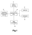
- FIG. 1 is a block diagram illustrating a configuration of the present apparatus.
- FIG. 2 illustrates configuration of meshes.
- FIGS. 3 and 4 illustrate mesh numbering.
- FIG. 5 illustrates borders of the meshes.
- FIG. 6 illustrates integration of the meshes.
- FIG. 7 illustrates numbering of the integrated meshes.
- FIG. 8 illustrates a search for a facility.
- FIGS. 9 and 10 illustrate examples of displaying search results.
- FIG. 11 illustrates configuration of records.
- FIG. 1 is a block diagram illustrating an overall configuration of a navigation apparatus.
- a navigation ECU 10 performs various types of data processing for navigation, and is connected to a variety of devices as shown in the figure.
- a position detecting device 12 including a GPS device or the like detects the current position of a vehicle. Various devices such as D-GPS devices, beacon receivers, and azimuth detecting devices may be employed.
- An input device 14 is used for entering commands such as operation commands, and formed by operation buttons, a touch panel, or the like.
- a display 16 presents a map image or the like used for navigation. When the input device 14 is a touch panel, the display 16 is preferably provided with a touch switch on a front surface thereof.
- a speaker 18 provides audio output of route guidance, operation guidance, and the like.
- a map database 20 contains various map data.
- the navigation ECU 10 utilizes the map data to search for routes and facilities and display a map image.
- the map database 20 is carried on a storage medium such as a CD-ROM, a DVD, a hard disk, or the like.
- the input device 14 When, for example, a destination is set and a route thereto is to be searched for, the input device 14 is used for entering the destination.
- the destination can be input by, for example, entering the name or telephone number of the destination to cause the display 16 to present a corresponding map, and then touching a position of interest on the map.
- the navigation ECU 10 searches data on road network contained in the map database 20 for an optimum route from the current position to the destination. For this search, various search methods including Dikstra method may be employed.
- Dikstra method may be employed.
- route guidance Preferably, guidance on right or left turn at intersections are given by showing the direction on the display 16 as well as by speech from the speaker 18 .
- the map database 20 contains map data on the region where the vehicle travels. For example, for a vehicle travelling in Japan, the map database 20 may have stored therein nationwide map data of Japan. When traveling in Europe, map data of the countries of Europe can be stored therein.
- the entire world is divided into search meshes (units of divided area) having a prescribed size, and each search mesh is assigned a unique number used for arrangement.
- one search mesh has a size corresponding to 32 seconds ⁇ 32 seconds in terms of angle, or about 1 km ⁇ 1 km in terms of distance.
- respective search meshes are sequentially assigned with numbers following an N pattern. More specifically, referring to FIGS. 3 and 4, the lower left mesh is assigned number 1 , and numbers are sequentially assigned to adjoining meshes following an N pattern.
- the assignment process proceeds following an N pattern to sequentially allocate numbers to respective search meshes, and this process is repeated.
- the upper right point at maximum longitude (LOmax), maximum latitude (LAmax) is the base point that is assigned with the last number.
- the entire world is divided into four areas: north latitude, west longitude area; north latitude, east longitude area; south latitude, west longitude area; and south latitude, east longitude area.
- mesh numbers are sequentially assigned to the search meshes starting from the mesh located at the minimum latitude and longitude and ending with the mesh located at the maximum latitude and longitude.
- the area to which a point on the border belongs is determined by defining each area to include a point at the minimum longitude and latitude or over and exclude a point at the maximum longitude or latitude. Borders of the lower side and the left side indicated by solid lines in the figure are included in the respective areas.
- the map data is stored according to mesh numbers. That is, the map database 20 is carried on a storage medium such as a CD-ROM, a DVD, a hard disk, or the like, and the map data is linearly arranged and stored in order of mesh number.
- Navigation apparatuses often require adjacent map data portions for displaying a map or searching for a facility.
- mesh numbers are assigned to respective search meshes following an N pattern.
- search meshes located in close proximity are assigned proximate mesh numbers, and are located in close proximity on the storage medium, allowing for rapid and efficient access to the stored data.
- the map data is stored based on the search meshes, each of which basically has a fixed size (1 km ⁇ 1 km in the above example) determined by longitude and latitude.
- the search range may be, for example, a 10 kilometer circle. For this range, as many as 100 search meshes are searched. Consequently, data acquisition will be inefficient if data is sequentially retrieved for one search mesh after another.
- a certain number of search meshes are preferably integrated for management. More specifically, a collection of four search meshes is regarded as a mesh at an integration degree 1 , and a collection of 16 search meshes as a mesh at an integration degree 2 . Thus, 4 n meshes are collectively treated wherein n denotes the degree of integration.
- a mesh management section stores mesh numbers in accordance with the degree of integration. For a mesh assigned with number 1 at integration degree 0 , a search frame management section for integration degree 0 accesses the map data portion having a mesh number MAP 1 . For an access to a mesh number MAP 4 at integration degree 1 , a search frame management section for integration degree 1 is used and the map data portions assigned with mesh numbers MAP 4 -MAP 7 are accessed. Further, for an access to the mesh number MAP 0 at integration degree 2 , a search frame management section for integration degree 2 is used and the map data portions assigned with mesh numbers MAP 0 -MAP 15 are accessed.
- the searched data includes information such as a type code (category of facility), coordinates (position of facility), a pointer to position information (address at which detailed data of the facility is stored), and the like.
- some search meshes When the world is divided into search meshes of a fixed size, some search meshes include a large volume of map data while others include little. It is not efficient to assign a mesh number to a search mesh with no map data. Therefore, preferably some search meshes are integrated. Referring to FIG. 7, some search meshes are actively integrated, and a mesh number for one of the meshes in the integrated mesh represents the integrated mesh, so that the integrated mesh can be treated as a single search mesh.
- an area composed of 16 base meshes includes 9 meshes, i.e. 5 meshes at integration degree 0 and 4 meshes at integration degree 1 .
- a search for a facility near the current position will be discussed with reference to FIG. 8 .
- data on facilities and the like are separately stored as a different database from the map data used for display.
- the volume of data in the map database used for display is reduced, thereby enhancing the scrolling speed of the displayed map.
- a user When searching for a facility, a user first inputs a category of the facility, such as “restaurant”, to thereby specify the type code.
- the navigation ECU 10 determines, in view of the current position, a search range surrounding the current position, and identifies the corresponding search mesh number.
- the search range may be determined automatically using the default range, or by user input.
- the facility search information corresponding to the meshes in the search range is searched to determine if there is a facility of the specified category (such as a restaurant).
- a facility search is performed on the data that is used for searches and stored according to mesh number.
- Such data for searches and detailed data described hereinafter are all stored separately from the map data for display.
- the area to be searched is determined and the facility search is performed.
- a search is performed by accessing data of the base mesh identified by the integrated mesh, so that meshes are retrieved by a collective readout. Because data is arranged according to mesh number, the data portions having proximate position coordinates are located in close proximity, and the storage medium can be efficiently accessed.
- the facility search information includes a pointer to detailed information, and this pointer is used for reading out detailed data on the facility of interest.
- the detailed data is also stored according to mesh number. Therefore, a plurality of detailed data portions corresponding to a result of the surrounding area search are stored relatively close to each other, further enhancing access efficiency.
- a search can be made by specifying a building. More specifically, when a user inputs data to specify the building, such as the name or address thereof, the building of interest is searched for based on the input criteria. A building ID is assigned to each building for identification. The detailed data portions for one mesh are arranged according to building ID. Thus, when facilities are to be searched for on a building-by-building basis, the data portions for facilities in one building are arranged in close proximity, to thereby further enhance access efficiency.
- a category of a facility such as a restaurant, is specified to search for a facility of interest.
- the word “Toyota” can be input to search for a facility of this name. Map data over a predetermined range is then searched for facilities whose name begins with a variation of “Toyota”.
- Three names i.e. “Toyota School Foundation”, “Toyota Motor Corporation”, and “Toyota Automatic Loom Works”, are retrieved as a result of the search, with the set of facilities starting with “Toyota Motor Corporation” including four facilities, namely, “Toyota Motor Corporation, Takaoka Factory”, “Toyota Motor Corporation, Tsutsumi Factory”, “Toyota Motor Corporation, Factory at Headquarters”, and “Toyota Motor Corporation, Motomachi Factory”.
- data to be displayed is divided into groups according to a predetermined rule and the data thus grouped is displayed, so that it is easier to see the displayed search result. Further, constituents of the group are displayed by a predetermined operation to specify a facility, and it is possible to obtain display of the location of the facility on the map or of the details.
- the map database 20 contains detailed data on facilities.
- the facility data does not always include the same type of description. More specifically, for some facilities data is present for all items, such as telephone number, capacity, and fees, while for other facilities no data exists for certain items. Therefore, if each item has a fixed length for each facility, many empty data segments are inefficiently generated.
- a management field is provided for data of one facility (one record) to store data on whether or not data is present for each item, as shown in FIG. 11 .
- the management field is formed of 8 bits, and a bit “1” indicates that corresponding data is present.
- the management field for a record 1 is “11010111”, meaning that items 1 , 2 , 4 , 6 , 7 , and 8 include data, and therefore the length and content of these items 1 , 2 , 4 , 6 , 7 , and 8 are sequentially described.
- a record 2 has a management field of “10101010”
- data for only the four items, namely items 1 , 3 , 5 , and 7 are described.
- a record 3 has a management field of “00101000”, and therefore only the data for items 3 and 5 are stored.
- each record has a variable length determined according to its content, so that stored.
- each record has a variable length determined according to its content, so that the storage area can be efficiently utilized for the database that contains records with many of which lack some segments.
- a type code usually has a fixed length of 2 bytes, data on length can be omitted. It is also possible to omit the item in a management field which always requires description. Further, the management field need not be positioned at the head of each record, and it may be stored in a different memory area (such as a definition file of a record).
- meshes located in close proximity are numbered according to a predetermined rule, and map data is stored in numerical order, so that data portions for the meshes located in close proximity on the map are also positioned in close proximity in a storage medium. Because the map database is often used for a search over relatively wide areas and data portions for such areas are located in close proximity on the storage medium, efficiency of accessing the storage medium for a search is improved.
- mesh members are assigned to respective search meshes following N pattern, z pattern can be equally adopted where desired.
Landscapes
- Engineering & Computer Science (AREA)
- Radar, Positioning & Navigation (AREA)
- Remote Sensing (AREA)
- Databases & Information Systems (AREA)
- Automation & Control Theory (AREA)
- Physics & Mathematics (AREA)
- General Physics & Mathematics (AREA)
- Navigation (AREA)
- Information Retrieval, Db Structures And Fs Structures Therefor (AREA)
- Instructional Devices (AREA)
- Traffic Control Systems (AREA)
- Processing Or Creating Images (AREA)
Abstract
Description
Claims (8)
Applications Claiming Priority (3)
| Application Number | Priority Date | Filing Date | Title |
|---|---|---|---|
| JPHEI-11-102417 | 1999-04-09 | ||
| JP11-102417 | 1999-04-09 | ||
| JP11102417A JP2000293099A (en) | 1999-04-09 | 1999-04-09 | Map database |
Publications (2)
| Publication Number | Publication Date |
|---|---|
| US20010051851A1 US20010051851A1 (en) | 2001-12-13 |
| US6556919B2 true US6556919B2 (en) | 2003-04-29 |
Family
ID=14326882
Family Applications (1)
| Application Number | Title | Priority Date | Filing Date |
|---|---|---|---|
| US09/540,762 Expired - Lifetime US6556919B2 (en) | 1999-04-09 | 2000-03-31 | Map data storage medium |
Country Status (6)
| Country | Link |
|---|---|
| US (1) | US6556919B2 (en) |
| EP (1) | EP1043567B1 (en) |
| JP (1) | JP2000293099A (en) |
| CN (1) | CN100514393C (en) |
| DE (1) | DE60044629D1 (en) |
| WO (1) | WO2000062270A1 (en) |
Cited By (12)
| Publication number | Priority date | Publication date | Assignee | Title |
|---|---|---|---|---|
| US20040243304A1 (en) * | 2003-06-02 | 2004-12-02 | Noriko Kato | Map information retrieving |
| WO2006011278A1 (en) | 2004-07-29 | 2006-02-02 | Hitachi, Ltd. | Map data delivering device, communication terminal, and map delivering method |
| US20060129536A1 (en) * | 2000-04-18 | 2006-06-15 | Foulger Michael G | Interactive intelligent searching with executable suggestions |
| US20070016562A1 (en) * | 2000-04-25 | 2007-01-18 | Cooper Jeremy S | System and method for proximity searching position information using a proximity parameter |
| US20070150804A1 (en) * | 2000-04-18 | 2007-06-28 | Kforce Inc. | Method, system, and computer program product for propagating remotely configurable posters of host site content |
| US20090094541A1 (en) * | 2000-04-25 | 2009-04-09 | Foulger Michael G | Methods, Systems and Computer Program Products for Scheduling Executions of Programs |
| US7672778B1 (en) | 2004-07-20 | 2010-03-02 | Navteq North America, Llc | Navigation system with downloaded map data |
| US20100075643A1 (en) * | 2004-09-07 | 2010-03-25 | Tierravision, Inc. | System and method of wireless downloads of map and geographic based data to portable computing devices |
| US7693950B2 (en) | 2000-04-25 | 2010-04-06 | Foulger Michael G | System and method related to generating and tracking an email campaign |
| USRE41983E1 (en) | 2000-09-22 | 2010-12-07 | Tierravision, Inc. | Method of organizing and compressing spatial data |
| US7924170B1 (en) | 2005-12-19 | 2011-04-12 | Wavetronix Llc | Detecting targets in roadway intersections |
| USRE48781E1 (en) | 2001-09-27 | 2021-10-19 | Wavetronix Llc | Vehicular traffic sensor |
Families Citing this family (35)
| Publication number | Priority date | Publication date | Assignee | Title |
|---|---|---|---|---|
| US6405128B1 (en) | 1999-12-20 | 2002-06-11 | Navigation Technologies Corp. | Method and system for providing an electronic horizon in an advanced driver assistance system architecture |
| US6829690B1 (en) * | 2000-05-23 | 2004-12-07 | Navteq North America, Llc | Method and system for accessing spatially organized geographic data in blocks |
| JP3302986B1 (en) * | 2000-09-20 | 2002-07-15 | 昇 正岡 | Information management system |
| US7689621B1 (en) * | 2000-11-06 | 2010-03-30 | Navteq North America, Llc | Multi-dimensional spatial index for a geographic database |
| EP1288625B1 (en) * | 2001-08-31 | 2011-07-27 | Pioneer Corporation | Communication-type navigation apparatus and server device |
| JP4810024B2 (en) * | 2001-09-07 | 2011-11-09 | ソニーフィナンシャルホールディングス株式会社 | Insurance premium calculation system, insurance premium calculation server, insurance premium calculation method, and insurance premium calculation program |
| JP4400775B2 (en) | 2002-05-28 | 2010-01-20 | パイオニア株式会社 | Navigation device, facility search method, program, and recording medium for recording program |
| US6782319B1 (en) | 2002-11-26 | 2004-08-24 | Navteq North America, Llc | Method for organizing map data |
| US7099882B2 (en) * | 2003-04-29 | 2006-08-29 | Navteq North America, Llc | Method and system for forming, updating, and using a geographic database |
| US7801897B2 (en) | 2004-12-30 | 2010-09-21 | Google Inc. | Indexing documents according to geographical relevance |
| GB2429800A (en) * | 2005-05-13 | 2007-03-07 | Ls2003 Ltd | Spatial data partitioning |
| WO2007030689A2 (en) * | 2005-09-09 | 2007-03-15 | Agilemesh, Inc. | Surveillance apparatus and method for wireless mesh network |
| US7684017B2 (en) | 2006-10-26 | 2010-03-23 | Callaway Golf Company | Laser range finder for use on a golf course |
| CN101046383B (en) * | 2007-04-27 | 2010-11-10 | 江苏华科导航科技有限公司 | Method for navigation instrument to search interest points along guide path during navigation |
| KR100967930B1 (en) | 2008-01-02 | 2010-07-06 | (주)엠앤소프트 | Apparatus and Method for grouping land/sea parcels using administrative data |
| US8339417B2 (en) * | 2008-07-25 | 2012-12-25 | Navteq B.V. | Open area maps based on vector graphics format images |
| US8417446B2 (en) * | 2008-07-25 | 2013-04-09 | Navteq B.V. | Link-node maps based on open area maps |
| US8374780B2 (en) * | 2008-07-25 | 2013-02-12 | Navteq B.V. | Open area maps with restriction content |
| US8229176B2 (en) * | 2008-07-25 | 2012-07-24 | Navteq B.V. | End user image open area maps |
| US8825387B2 (en) * | 2008-07-25 | 2014-09-02 | Navteq B.V. | Positioning open area maps |
| US8099237B2 (en) | 2008-07-25 | 2012-01-17 | Navteq North America, Llc | Open area maps |
| US20100023251A1 (en) * | 2008-07-25 | 2010-01-28 | Gale William N | Cost based open area maps |
| US9116003B2 (en) | 2009-10-01 | 2015-08-25 | Qualcomm Incorporated | Routing graphs for buildings |
| US8812015B2 (en) | 2009-10-01 | 2014-08-19 | Qualcomm Incorporated | Mobile device locating in conjunction with localized environments |
| US8880103B2 (en) | 2009-10-12 | 2014-11-04 | Qualcomm Incorporated | Method and apparatus for transmitting indoor context information |
| US9389085B2 (en) | 2010-01-22 | 2016-07-12 | Qualcomm Incorporated | Map handling for location based services in conjunction with localized environments |
| CN102147979A (en) * | 2010-02-09 | 2011-08-10 | 厦门雅迅网络股份有限公司 | Method for rapidly locating current region of vehicle |
| JP5782948B2 (en) * | 2011-09-15 | 2015-09-24 | 富士通株式会社 | Information management method and information management apparatus |
| CN102508849A (en) * | 2011-09-28 | 2012-06-20 | 安徽科蓝智能技术有限公司 | Numbering method for intelligently positioning scattered fixed objects for GIS (geographic information system) |
| CN102567523B (en) * | 2011-12-29 | 2014-02-26 | 武汉大学 | Method for adaptively designing space sampling scheme of geographic elements with aggregated distribution characteristic |
| WO2014057526A1 (en) * | 2012-10-09 | 2014-04-17 | 三菱電機株式会社 | Map data storage device and map display device |
| US20140257687A1 (en) * | 2013-03-08 | 2014-09-11 | Qualcomm Incorporated | Pyramid mapping data structure for indoor navigation |
| JP6236845B2 (en) * | 2013-04-16 | 2017-11-29 | 株式会社デンソー | Map display device |
| CN105556510B (en) * | 2013-09-17 | 2020-03-03 | 三菱电机株式会社 | Map information processing device, data generation method, and program |
| CN104697537A (en) * | 2015-02-10 | 2015-06-10 | 柳州市金旭节能科技有限公司 | Non-standard traffic small district map matching method |
Citations (14)
| Publication number | Priority date | Publication date | Assignee | Title |
|---|---|---|---|---|
| JPS60239876A (en) | 1984-05-15 | 1985-11-28 | Setsutaka Tomochika | Method for retrieving specific divided area out of wide range pattern area |
| EP0280795A1 (en) | 1986-10-23 | 1988-09-07 | Koninklijke Philips Electronics N.V. | Method and apparatus for storing a digital data base divided into parcels |
| US4937572A (en) | 1985-04-27 | 1990-06-26 | Nippondenso Co., Ltd. | Map display apparatus storing data of physically adjacent map sections in physically adjacent storage locations |
| JPH02240680A (en) | 1989-03-14 | 1990-09-25 | Matsushita Electric Ind Co Ltd | Map reading out device |
| US5486822A (en) | 1990-11-09 | 1996-01-23 | Sumitomo Electric Industries, Ltd. | Optimum route determination |
| DE19709773A1 (en) | 1996-03-11 | 1997-10-30 | Denso Corp | Identifying method for points on map using reduced reference information |
| US5742924A (en) | 1994-12-02 | 1998-04-21 | Nissan Motor Co., Ltd. | Apparatus and method for navigating mobile body using road map displayed in form of bird's eye view |
| US5839088A (en) | 1996-08-22 | 1998-11-17 | Go2 Software, Inc. | Geographic location referencing system and method |
| JPH10333553A (en) | 1997-05-30 | 1998-12-18 | Matsushita Electric Ind Co Ltd | On-vehicle information display device |
| US6006161A (en) * | 1996-08-02 | 1999-12-21 | Aisin Aw Co., Ltd. | Land vehicle navigation system with multi-screen mode selectivity |
| US6023655A (en) * | 1996-12-16 | 2000-02-08 | Xanavi Informatics Corporation | Map database apparatus |
| US6023653A (en) * | 1995-11-30 | 2000-02-08 | Fujitsu Ten Limited | Vehicle position detecting apparatus |
| US6122200A (en) * | 1997-11-26 | 2000-09-19 | Stmicroelectronics, S.R.L. | Row decoder for a flash-EEPROM memory device with the possibility of selective erasing of a sub-group of rows of a sector |
| US6141014A (en) * | 1995-04-20 | 2000-10-31 | Hitachi, Ltd. | Bird's-eye view forming method, map display apparatus and navigation system |
Family Cites Families (1)
| Publication number | Priority date | Publication date | Assignee | Title |
|---|---|---|---|---|
| CN1228864A (en) * | 1997-07-02 | 1999-09-15 | 三菱电机株式会社 | Vehicle navigator |
-
1999
- 1999-04-09 JP JP11102417A patent/JP2000293099A/en active Pending
-
2000
- 2000-03-31 US US09/540,762 patent/US6556919B2/en not_active Expired - Lifetime
- 2000-04-06 DE DE60044629T patent/DE60044629D1/en not_active Expired - Lifetime
- 2000-04-06 EP EP00107506A patent/EP1043567B1/en not_active Expired - Lifetime
- 2000-04-10 WO PCT/JP2000/002326 patent/WO2000062270A1/en active Search and Examination
- 2000-04-10 CN CNB008079250A patent/CN100514393C/en not_active Expired - Lifetime
Patent Citations (16)
| Publication number | Priority date | Publication date | Assignee | Title |
|---|---|---|---|---|
| JPS60239876A (en) | 1984-05-15 | 1985-11-28 | Setsutaka Tomochika | Method for retrieving specific divided area out of wide range pattern area |
| US4937572A (en) | 1985-04-27 | 1990-06-26 | Nippondenso Co., Ltd. | Map display apparatus storing data of physically adjacent map sections in physically adjacent storage locations |
| EP0280795A1 (en) | 1986-10-23 | 1988-09-07 | Koninklijke Philips Electronics N.V. | Method and apparatus for storing a digital data base divided into parcels |
| JPH02240680A (en) | 1989-03-14 | 1990-09-25 | Matsushita Electric Ind Co Ltd | Map reading out device |
| US5486822A (en) | 1990-11-09 | 1996-01-23 | Sumitomo Electric Industries, Ltd. | Optimum route determination |
| US5742924A (en) | 1994-12-02 | 1998-04-21 | Nissan Motor Co., Ltd. | Apparatus and method for navigating mobile body using road map displayed in form of bird's eye view |
| US6141014A (en) * | 1995-04-20 | 2000-10-31 | Hitachi, Ltd. | Bird's-eye view forming method, map display apparatus and navigation system |
| US6023653A (en) * | 1995-11-30 | 2000-02-08 | Fujitsu Ten Limited | Vehicle position detecting apparatus |
| US6006160A (en) * | 1996-03-11 | 1999-12-21 | Denso Corporation | System and method for designating points on a map using reduced designation information |
| US6122594A (en) * | 1996-03-11 | 2000-09-19 | Denson Corporation | System and method for designating points on a map using reduced designation information |
| DE19709773A1 (en) | 1996-03-11 | 1997-10-30 | Denso Corp | Identifying method for points on map using reduced reference information |
| US6006161A (en) * | 1996-08-02 | 1999-12-21 | Aisin Aw Co., Ltd. | Land vehicle navigation system with multi-screen mode selectivity |
| US5839088A (en) | 1996-08-22 | 1998-11-17 | Go2 Software, Inc. | Geographic location referencing system and method |
| US6023655A (en) * | 1996-12-16 | 2000-02-08 | Xanavi Informatics Corporation | Map database apparatus |
| JPH10333553A (en) | 1997-05-30 | 1998-12-18 | Matsushita Electric Ind Co Ltd | On-vehicle information display device |
| US6122200A (en) * | 1997-11-26 | 2000-09-19 | Stmicroelectronics, S.R.L. | Row decoder for a flash-EEPROM memory device with the possibility of selective erasing of a sub-group of rows of a sector |
Cited By (28)
| Publication number | Priority date | Publication date | Assignee | Title |
|---|---|---|---|---|
| US20100223275A1 (en) * | 2000-04-18 | 2010-09-02 | Foulger Michael G | Interactive Intelligent Searching with Executable Suggestions |
| US8055605B2 (en) | 2000-04-18 | 2011-11-08 | Archeron Limited Llc | Interactive intelligent searching with executable suggestions |
| US20060129536A1 (en) * | 2000-04-18 | 2006-06-15 | Foulger Michael G | Interactive intelligent searching with executable suggestions |
| US7730008B2 (en) | 2000-04-18 | 2010-06-01 | Foulger Michael G | Database interface and database analysis system |
| US8266242B2 (en) | 2000-04-18 | 2012-09-11 | Archeron Limited L.L.C. | Method, system, and computer program product for propagating remotely configurable posters of host site content |
| US8219516B2 (en) | 2000-04-18 | 2012-07-10 | Archeron Limited Llc | Interactive intelligent searching with executable suggestions |
| US20070150804A1 (en) * | 2000-04-18 | 2007-06-28 | Kforce Inc. | Method, system, and computer program product for propagating remotely configurable posters of host site content |
| US20070204219A1 (en) * | 2000-04-18 | 2007-08-30 | Foulger Michael G | Method, system, and computer program product for propagating remotely configurable posters of host site content |
| US8156499B2 (en) | 2000-04-25 | 2012-04-10 | Icp Acquisition Corporation | Methods, systems and articles of manufacture for scheduling execution of programs on computers having different operating systems |
| US7783621B2 (en) * | 2000-04-25 | 2010-08-24 | Cooper Jeremy S | System and method for proximity searching position information using a proximity parameter |
| US20090094541A1 (en) * | 2000-04-25 | 2009-04-09 | Foulger Michael G | Methods, Systems and Computer Program Products for Scheduling Executions of Programs |
| US20070016562A1 (en) * | 2000-04-25 | 2007-01-18 | Cooper Jeremy S | System and method for proximity searching position information using a proximity parameter |
| US7693950B2 (en) | 2000-04-25 | 2010-04-06 | Foulger Michael G | System and method related to generating and tracking an email campaign |
| USRE41983E1 (en) | 2000-09-22 | 2010-12-07 | Tierravision, Inc. | Method of organizing and compressing spatial data |
| USRE48781E1 (en) | 2001-09-27 | 2021-10-19 | Wavetronix Llc | Vehicular traffic sensor |
| US7092817B2 (en) | 2003-06-02 | 2006-08-15 | Denso Corporation | Map information retrieving |
| US20040243304A1 (en) * | 2003-06-02 | 2004-12-02 | Noriko Kato | Map information retrieving |
| US8010227B2 (en) | 2004-07-20 | 2011-08-30 | Navteq North America, Llc | Navigation system with downloadable map data |
| US7672778B1 (en) | 2004-07-20 | 2010-03-02 | Navteq North America, Llc | Navigation system with downloaded map data |
| EP1785968A4 (en) * | 2004-07-29 | 2013-05-01 | Hitachi Ltd | Map data delivering device, communication terminal, and map delivering method |
| EP1785968A1 (en) * | 2004-07-29 | 2007-05-16 | Hitachi, Ltd. | Map data delivering device, communication terminal, and map delivering method |
| WO2006011278A1 (en) | 2004-07-29 | 2006-02-02 | Hitachi, Ltd. | Map data delivering device, communication terminal, and map delivering method |
| US20100075643A1 (en) * | 2004-09-07 | 2010-03-25 | Tierravision, Inc. | System and method of wireless downloads of map and geographic based data to portable computing devices |
| US8014945B2 (en) | 2004-09-07 | 2011-09-06 | Tierravision, Inc. | System and method of wireless downloads of map and geographic based data to portable computing devices |
| US8649968B2 (en) | 2004-09-07 | 2014-02-11 | Tierravision, Inc. | System and method of wireless downloads of map and geographic based data to portable computing devices |
| US9137633B2 (en) | 2004-09-07 | 2015-09-15 | Tierravision, Inc. | System and method of wireless downloads of map and geographic based data to portable computing devices |
| US10244361B1 (en) | 2004-09-07 | 2019-03-26 | Tierravision, Inc. | System and method of wireless downloads of map and geographic based data to portable computing devices |
| US7924170B1 (en) | 2005-12-19 | 2011-04-12 | Wavetronix Llc | Detecting targets in roadway intersections |
Also Published As
| Publication number | Publication date |
|---|---|
| CN100514393C (en) | 2009-07-15 |
| EP1043567A2 (en) | 2000-10-11 |
| CN1351741A (en) | 2002-05-29 |
| EP1043567A3 (en) | 2001-08-08 |
| DE60044629D1 (en) | 2010-08-19 |
| EP1043567B1 (en) | 2010-07-07 |
| JP2000293099A (en) | 2000-10-20 |
| US20010051851A1 (en) | 2001-12-13 |
| WO2000062270A1 (en) | 2000-10-19 |
Similar Documents
| Publication | Publication Date | Title |
|---|---|---|
| US6556919B2 (en) | Map data storage medium | |
| KR100613416B1 (en) | Map information retrieving | |
| US6574554B1 (en) | System and method for calculating a navigation route based on non-contiguous cartographic map databases | |
| JP4111883B2 (en) | POI information display method and navigation system | |
| EP1202029B1 (en) | Method and system for compact representation of routes | |
| JP3842799B2 (en) | Map data providing device | |
| EP2487461B1 (en) | Vehicle navigation device and method | |
| US6807480B1 (en) | Navigation system and a memory medium | |
| JP2006308579A (en) | Method of organizing map data for affinity, and application for use thereof | |
| US7599791B2 (en) | Spot searching device, navigation apparatus, spot searching method, spot searching program, and information recording medium having spot searching program | |
| US6233521B1 (en) | Map database apparatus | |
| US6560530B1 (en) | Navigation system | |
| EP1548686B1 (en) | Map data product and map data processor | |
| US20080040032A1 (en) | System for searching intersections and method thereof | |
| US20050021510A1 (en) | Data search apparatus and method, navigation apparatus and method, data set and computer program product for data search | |
| US7647341B2 (en) | Map editing-and-displaying apparatus, map managing system, map managing method, and map storing medium | |
| JP4145596B2 (en) | Map data processor | |
| JP4145597B2 (en) | Map data processor | |
| JP3413748B2 (en) | Route search method for in-vehicle navigation device | |
| JPH0715386B2 (en) | Car navigation system | |
| JP2000285119A (en) | Device, system and controlling method for information processing and storage medium with its control program stored therein | |
| US20090234566A1 (en) | Method for the input of a destination and navigation device |
Legal Events
| Date | Code | Title | Description |
|---|---|---|---|
| AS | Assignment |
Owner name: TOYOTA JIDOSHA KABUSHIKI KAISHA, JAPAN Free format text: ASSIGNMENT OF ASSIGNORS INTEREST;ASSIGNORS:SUZUKI, HIDENOBU;FURUIKE, YOSHIMASA;TOOYAMA, YASUHIRO;AND OTHERS;REEL/FRAME:010891/0005;SIGNING DATES FROM 20000305 TO 20000308 Owner name: DENSO CORPORATION, JAPAN Free format text: ASSIGNMENT OF ASSIGNORS INTEREST;ASSIGNORS:SUZUKI, HIDENOBU;FURUIKE, YOSHIMASA;TOOYAMA, YASUHIRO;AND OTHERS;REEL/FRAME:010891/0005;SIGNING DATES FROM 20000305 TO 20000308 Owner name: AISIN AW CO. LTD., JAPAN Free format text: ASSIGNMENT OF ASSIGNORS INTEREST;ASSIGNORS:SUZUKI, HIDENOBU;FURUIKE, YOSHIMASA;TOOYAMA, YASUHIRO;AND OTHERS;REEL/FRAME:010891/0005;SIGNING DATES FROM 20000305 TO 20000308 Owner name: FUJITSU TEN LIMITED, JAPAN Free format text: ASSIGNMENT OF ASSIGNORS INTEREST;ASSIGNORS:SUZUKI, HIDENOBU;FURUIKE, YOSHIMASA;TOOYAMA, YASUHIRO;AND OTHERS;REEL/FRAME:010891/0005;SIGNING DATES FROM 20000305 TO 20000308 Owner name: MATSUSHITA ELECTRIC INDUSTRIAL CO., LTD., JAPAN Free format text: ASSIGNMENT OF ASSIGNORS INTEREST;ASSIGNORS:SUZUKI, HIDENOBU;FURUIKE, YOSHIMASA;TOOYAMA, YASUHIRO;AND OTHERS;REEL/FRAME:010891/0005;SIGNING DATES FROM 20000305 TO 20000308 |
|
| FEPP | Fee payment procedure |
Free format text: PAYOR NUMBER ASSIGNED (ORIGINAL EVENT CODE: ASPN); ENTITY STATUS OF PATENT OWNER: LARGE ENTITY |
|
| STCF | Information on status: patent grant |
Free format text: PATENTED CASE |
|
| CC | Certificate of correction | ||
| FPAY | Fee payment |
Year of fee payment: 4 |
|
| FPAY | Fee payment |
Year of fee payment: 8 |
|
| FPAY | Fee payment |
Year of fee payment: 12 |