
Chaf and Chamkhaleh
Chaf and Chamkhaleh
Persian: چاف و چمخاله | |
|---|---|
City | |
 Harbor and lighthouse in Chaf and Chamkhaleh | |
 Chaf and Chamkhaleh | |
| Coordinates: 37°13′46″N 50°15′16″E / 37.22944°N 50.25444°E[1] | |
| Country | Iran |
| Province | Gilan |
| County | Langarud |
| District | Central |
| Population (2016)[2] | |
| • Total | 8,840 |
| Time zone | UTC+3:30 (IRST) |
Chaf and Chamkhaleh (Persian: چاف و چمخاله)[a] is a city in the Central District of Langarud County, Gilan province of northwestern Iran, serving as the administrative center for Chaf Rural District.[5] The city is located on the Caspian Sea.
Chaf and Chamkhaleh is a merger of the former villages of Chaf-e Bala, Chaf-e Pain, Chamkhaleh, Galesh Kolam, Hoseynabad-e Chaf, Kamal ol Din Poshteh, Mian Mahalleh-ye Pap Kiadeh, Pain Pap Kiadeh, Palat Kaleh, Pir Poshteh, Radar Kumeh, Soltan Moradi, Tappeh, and Tazehabad-e Chaf.[4]
Demographics
[edit]Population
[edit]At the time of the 2011 National Census, the city's population was 4,494 in 1,436 households.[6] The 2016 census measured the population of the city as 8,840 people in 3,137 households.[2]
Gallery
[edit]-
 Road sign: "Experience Chaf and Chamkhale"
 -
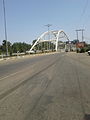 Chamkhaleh Bridge
 -
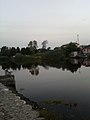 Chamkhaleh River


![]() Media related to Chaf and Chamkhaleh at Wikimedia Commons
Media related to Chaf and Chamkhaleh at Wikimedia Commons
Notes
[edit]References
[edit]- ^ OpenStreetMap contributors (13 October 2024). "Chaf and Chamkhaleh, Langarud County" (Map). OpenStreetMap (in Persian). Retrieved 13 October 2024.
- ^ a b Census of the Islamic Republic of Iran, 1395 (2016): Gilan Province. amar.org.ir (Report) (in Persian). The Statistical Center of Iran. Archived from the original (Excel) on 4 December 2020. Retrieved 19 December 2022.
- ^ Chaf and Chamkhaleh can be found at GEOnet Names Server, at this link, by opening the Advanced Search box, entering "-3057972" in the "Unique Feature Id" form, and clicking on "Search Database".
- ^ a b Rahimi, Mohammad Reza (c. 2023) [Approved 18 May 1388]. Divisional changes and reforms in Gilan province. qavanin.ir (Report) (in Persian). Ministry of the Interior, Political and Defense Commission. Proposal 4/1/42/91506; Resolution 158802/T38854H. Archived from the original on 5 October 2023. Retrieved 5 October 2023 – via Laws and Regulations Portal of the Islamic Republic of Iran.
- ^ Mousavi, Mirhossein (6 July 2015) [Approved 18 May 1366]. Creation and formation of six rural districts including villages, farms and places in Langarud County under Gilan province. rc.majlis.ir (Report) (in Persian). Ministry of the Interior, Board of Ministers. Proposal 53.1.11676; Notification 116984/T899. Archived from the original on 26 June 2016. Retrieved 13 December 2023 – via Islamic Parliament Research Center.
- ^ Census of the Islamic Republic of Iran, 1390 (2011): Gilan Province. irandataportal.syr.edu (Report) (in Persian). The Statistical Center of Iran. Archived from the original (Excel) on 8 October 2023. Retrieved 19 December 2022 – via Iran Data Portal, Syracuse University.
| Capital |  | |
|---|---|---|
| Counties and cities | ||
| Sights |
| |
| Populated places | ||
This Langarud County location article is a stub. You can help Wikipedia by expanding it. |