Category:Arrowhead Trail (auto trail)
Jump to navigation
Jump to search
former auto trail in the Western United States ,_main_road_from_Salt_Lake..._-_NARA_-_520405.jpg)  | |||||
| Upload media | |||||
| Instance of | |||||
|---|---|---|---|---|---|
| Location | |||||
| Length |
| ||||
| |||||
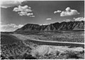
English: Media related to the Arrowhead Trail (auto trail), the first all-weather road in the Western United States that connected Los Angeles, California with Salt Lake City, Utah by way of Las Vegas, Nevada.
Media in category "Arrowhead Trail (auto trail)"
The following 8 files are in this category, out of 8 total.
-
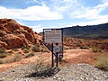 Arrowhead Trail (1914-1924), Nevada Historical Marker No. 168.jpg 4,000 × 3,000; 3.63 MB
-
 Arrowhead Trail Highway Marker.jpg 3,024 × 4,032; 3.66 MB
-
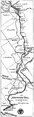 Arrowhead Trail Map.png 845 × 2,914; 834 KB
-
 Close up of Plaque on the Arrowhead Trail Highway Marker.jpg 4,032 × 3,024; 3.89 MB
-
 North along South Main Street, Springville, Utah Apr 16.jpg 2,592 × 1,944; 2.38 MB
-
 Part of the old Arrowhead Trail in south Spanish Fork.JPG 2,816 × 2,112; 2.34 MB
-
-

,_Nevada_Historical_Marker_No._168.jpg)


Categories:
- Auto trails
- Roads in Los Angeles County, California
- Roads in San Bernardino County, California
- Roads in Clark County, Nevada
- Transport in Mohave County, Arizona
- Former roads in Washington County, Utah
- Former roads in Iron County, Utah
- Former roads in Beaver County, Utah
- Foirmer foads in Millard County, Utah
- Former roads in Juab County, Utah
- Former roads in Utah County, Utah
- Former roads in Salt Lake County, Utah
- Former roads in Utah