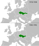
Fáìlì:LocationCzechoslovakia.png
Ìrísí
LocationCzechoslovakia.png (250 × 229 pixel, ìtóbi faili: 10 KB, irú MIME: image/png)
Ìtàn fáìlì
Ẹ kan kliki lórí ọjọ́ọdún/àkókò kan láti wo fáìlì ọ̀ún bó ṣe hàn ní àkókò na.
| Ọjọ́ọdún/Àkókò | Àwòrán kékeré | Àwọn ìwọ̀n | Oníṣe | Àríwí | |
|---|---|---|---|---|---|
| lọ́wọ́ | 18:03, 22 Oṣù Agẹmọ 2008 |  | 250 × 229 (10 KB) | Quadpus~commonswiki | Reverted to version as of 02:57, 30 May 2007 poor quality image, unknown reason for changing |
| 02:29, 16 Oṣù Agẹmọ 2008 |  | 250 × 342 (12 KB) | Rodolfo2008 | {{Information |Description=Location of Czechoslovakia 1918–1938 and 1945–1992and 1990-1993 (other european borders are correct for: 1919–1938 / 1956–1990) |Source=From en.wikipedia |Date= |Author=Rodolfo Perez Peña |Permission= |other_versions= } | |
| 02:57, 30 Oṣù Ẹ̀bìbì 2007 |  | 250 × 229 (10 KB) | Happenstance | larger dates | |
| 02:41, 30 Oṣù Ẹ̀bìbì 2007 |  | 250 × 229 (9 KB) | Happenstance | fx | |
| 02:40, 30 Oṣù Ẹ̀bìbì 2007 |  | 250 × 229 (10 KB) | Happenstance | borders corrected (correct as of 1921) | |
| 01:13, 23 Oṣù Ṣẹ̀rẹ́ 2007 |  | 250 × 229 (9 KB) | Happenstance | rv, even though the borders of the surrounding nations changed, that entire period saw borders transition as independences were recognized left, right and centre. I think it's wise to omit these changes because we simply can't have enough boxes to progres | |
| 08:24, 20 Oṣù Ṣẹ̀rẹ́ 2007 |  | 249 × 344 (14 KB) | Hoshie | added a box for post-communist Czechoslovakia. under same license as original. | |
| 01:22, 26 Oṣù Bélú 2006 |  | 250 × 229 (9 KB) | Happenstance | added 1918 to 1938 box | |
| 10:27, 20 Oṣù Ẹ̀rẹ̀nà 2005 |  | 250 × 115 (3 KB) | Thuresson | {{GFDL}} |
Ìlò fáìlì
Ojúewé kan yìí únlo fáìlì yí:
Ìlò fáìlì káàkiri
Àwọn wiki míràn wọ̀nyí lo fáìlì yìí:
- Ìlò ní ang.wikipedia.org
- Ìlò ní ar.wikipedia.org
- Ìlò ní arz.wikipedia.org
- Ìlò ní ast.wiktionary.org
- Ìlò ní azb.wikipedia.org
- Ìlò ní be-tarask.wikipedia.org
- Ìlò ní bn.wikipedia.org
- Ìlò ní bs.wikipedia.org
- Ìlò ní cy.wikipedia.org
- Ìlò ní de.wikipedia.org
- Ìlò ní dsb.wikipedia.org
- Ìlò ní frp.wikipedia.org
- Ìlò ní fr.wiktionary.org
- Ìlò ní fy.wikipedia.org
- Ìlò ní hsb.wikipedia.org
- Ìlò ní hy.wikipedia.org
- Ìlò ní incubator.wikimedia.org
- Ìlò ní io.wikipedia.org
- Ìlò ní kn.wikipedia.org
- Ìlò ní ku.wikipedia.org
- Ìlò ní la.wiktionary.org
- Ìlò ní mr.wikipedia.org
- Ìlò ní mzn.wikipedia.org
- Ìlò ní nl.wikipedia.org
- Ìlò ní nn.wikipedia.org
- Ìlò ní no.wikipedia.org
- Ìlò ní oc.wikipedia.org
- Ìlò ní pl.wiktionary.org
- Ìlò ní pt.wikiquote.org
- Ìlò ní pt.wiktionary.org
- Ìlò ní qu.wikipedia.org
- Ìlò ní scn.wikipedia.org
- Ìlò ní si.wikipedia.org
- Ìlò ní sl.wikipedia.org
Ìfihàn ìlò míràn púpọ̀ fún fálì yìí.


