Reawakening of the tropics
Despite closing out the month of August on a very quiet note, the tropical season has been fairly active thus far with 5 named storms, including a record-breaking, early season Category 5 Hurricane Beryl. We are only now nearing the season’s peak (September 10th) and the conditions for new tropical development are again starting to look favorable.
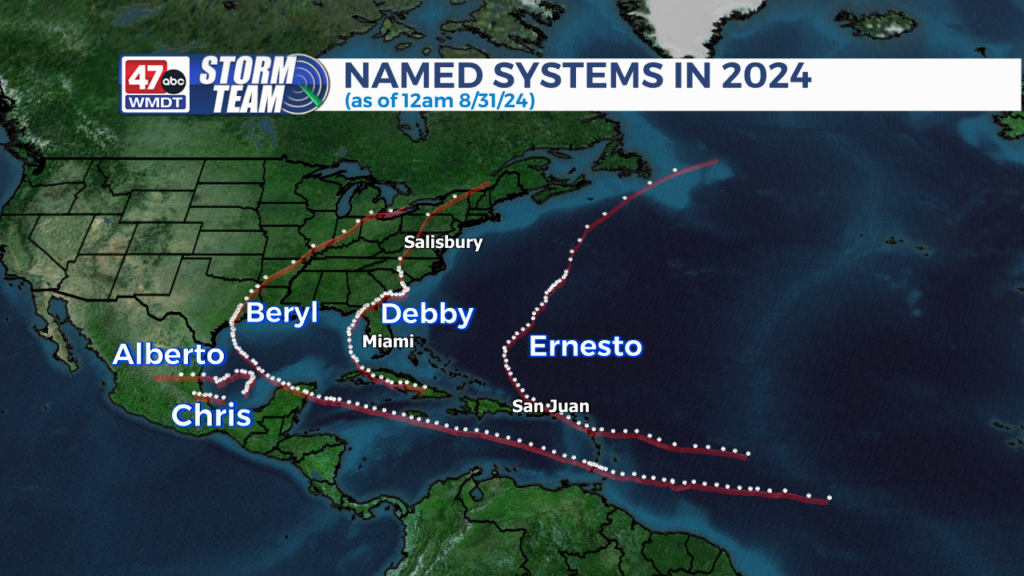
A considerable lull in tropical activity came on the heels of Hurricane Ernesto, with counterproductive factors such as Saharan dust from Africa and easterly wind shear in the upper levels inhibiting tropical development. Despite record warm ocean temperatures, temperatures aloft have been too warm for thunderstorm growth. (Cooler air aloft is necessary for the vertical cloud growth needed for large thunderstorms, which make up the core of tropical systems).

Now we are seeing a reversal in the trends of these variables. Diminishing Saharan dust and better upper level support have led to an awakening in the main development region of the Atlantic (the MDR, which stretches from the coast of western Africa to the Caribbean). 2 areas are now showing signs of possible tropical cyclone development in the next 7 days, with a 3rd wave slowly developing in the northern Gulf of Mexico.

Any tropical cyclone development will take a little time, as the first few days of September will shed more light on how conditions are progressing. However it will likely be sooner, rather than later, that we see Francine develop as the next named storm.


The 47abc Weather Team