Interactive Gettysburg: Using Modern Mapping Tools for a New Look at the Historical Battle
Seeing how Gettysburg played out on a map can help us understand why, in the end, it turned out as it did.
When Robert E. Lee looked out over the land at Gettysburg, 150 years ago this week, what could he see?
Not much, says Middlebury professor of geography Anne Kelly Knowles. That is her conclusion based on a nearly decade-long project to visualize the Battle of Gettysburg using advanced digital mapping techniques, available for your exploration at Smithsonian.com.
Recommended Reading


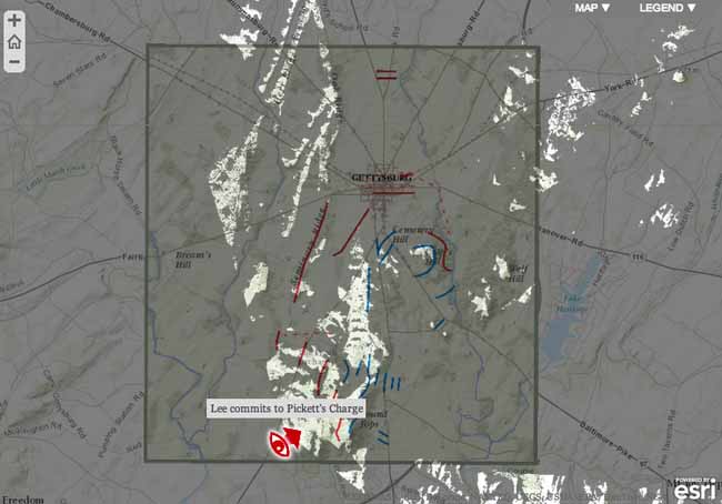
"What our visual terrain analysis shows is that Lee, at no point in the battle, could see how many federal forces kept arriving at the field," she told me. "He really had no idea how big the force was that he was attacking on day two and day three."
The idea of using GIS to map the historical battle first came to Knowles one morning 12 years ago. "I was literally brushing my teeth one morning and I thought, gosh, what could Lee see at Gettysburg?" she said.
Because surveillance technology at the time of the Civil War lacked aerial capabilities, intelligence about troop movements was limited to what generals and their scouts could actually see. Based on that visual information, generals had to make quick decisions about whether to attack and where to deploy troops. "I knew that GIS could help a person answer that question, because you can use it to analyze terrain three dimensionally," she explained.
Her project got a boost when she came across a map stored in the National Archives' Treasure Vault created in the late 1860s and early 1870s by the U.S. Army Corps of Engineers.
Knowles describes the map with enthusiasm. "It is enormous," she says It measures 12 by 13 feet, with each foot on the map measuring 1,200 feet on the ground, with a contour interval indicating every four feet of elevation change. It shows the buildings, the topography, the land cover, where the hardwood trees were, where the pines were, where the orchards were, whether fences were made of wood or stone. "The famous peach orchard that figures so importantly in the battle on the second day is labeled on the map and is shown by little tiny peach trees."
According to Knowles, "This was better than any modern data and it was historically accurate."

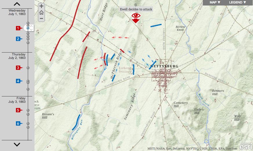
Information about the whereabouts and movements of the troops came from another source, the reporting of John B. Bachelder "a sort of mediocre landscape artist and cartographer from New Hampshire," as Knowles describes him. Bachelder, she says, "saw an opportunity in this incredibly important battle, rushed to the battlefield almost immediately after the battle, and started interviewing veterans of the battle -- foot soldiers, generals." He eventually secured $10,000 from Congress to complete his work and published 23 maps documenting the battle's play-by-play, sometimes showing the changing troop configurations at an increment of only half an hour. Knowles and research assistant Dan Miller digitized Bachelder's work onto their map, checking against other sources, she says, because Bachelder's data isn't perfectly accurate. Alex Tait of International Mapping Associates and Allen Carroll of ESRI's StoryMap project produced the historical basemap and brought everything together in the website.
"It's combining this historical terrain with the changing position of the troops and then digital technology -- of course is the other crucial element here -- that enables us to put ourselves on that recreated terrain and show, either in the panorama views or the viewsheds, what commanders could and could not see," Knowles told me. By exploring the map from Lee's perspective, she was able to see how "blind" he was -- how, when he decided on the battle's third day to launch his doomed assault, he could not have known the full extent or formation of the Union troops. "That really changed my view of the battle. It makes it look all the more hopeless and bold -- I guess, or foolish -- for Lee."
Of course, understanding the mechanics of the battle is not the same as understanding the war and its aftermath. As Yoni Appelbaum wrote for The Atlantic's commemorative Civil War issue about the Cyclorama another, earlier visualization of the Gettysburg battle:
The cyclorama re-created the Battle of Gettysburg in stunning realism, with impeccable attention to the smallest minutiae. Yet it offered not a single clue as to why the battle had been fought. No matter how hard they looked, or how long they stared, no visitor would find in the painting any trace of the cause of the war. There was carnage. There was valor. But there was no purpose.
Battles are not fought in isolation. At Gettysburg, two armies clashed. The North fought to ensure that a nation conceived in liberty, and dedicated to the proposition that all men are created equal, would long endure. Its victory secured a new birth of freedom, which increased and flourished during Reconstruction. But over the ensuing decades, the promise of Gettysburg faltered. Emancipation brought greater liberty, but for black Americans, there was no equality. The revolutionary changes wrought by Reconstruction were rolled slowly backward. The work that the Union dead had so nobly advanced was left unfinished; the great task remained.
Data visualization or mapping technologies do not themselves explain history -- that is why we have narrative non-fiction, documentaries, even, in some instances, movies -- but seeing how Gettysburg played out on a map can help us understand why, in the end, it turned out as it did.
About the Author