These ancient cities sunk to the ocean floor. Here's how they were rediscovered.
These coastal civilizations have long since disappeared under the waves. But new technology is revolutionizing underwater archaeology and surfacing the remains like never before.
Lost cities sunken beneath the waves are not just myths. Many coastal communities were swallowed up by the sea in the ancient world—their streets, homes, and temples all submerged under relentless tides.
For millennia legends swirled about these places, but their submarine statues made them impossible to explore in the field. Starting in the 20th century, breakthroughs in oceanography and marine science opened the door to underwater archaeology, allowing scholars to map sites, collect artifacts, and resurface the stories of these drowned cites.

Some of humanity’s earliest coastal settlements met their fate because of climate change. Using geomorphological, sedimentological, and paleontological data from the seabed, scientists have established that between 30,000 and 20,000 years ago, during the last glacial maximum, sea level was some 425 feet lower than it is today. At the end of this period, the sea level rose abruptly as polar ice caps melted. Many prehistoric settlements built along the coastlines flooded and were abandoned. The Submerged Prehistoric Archaeology and Landscapes of the Continental Shelf project has recently counted 2,600 such submerged sites in 19 countries—including the Cosquer cave in Marseille, France, famous for its paintings. The entrance to the cave lies about 100 feet deep.
(These six mystery islands existed only in the imaginations of ancient explorers—or did they?)
On shaky ground
People may call Earth terra firma, but nothing could be further from the truth. In reality, the planet is undergoing a continuous process of geological shifting, a constant transformation brought about by natural destruction and regeneration. As the tectonic plates move, earthquakes, volcanoes, tsunamis, and other seismic phenomena can cause the so-called solid ground to shake, crumble, liquefy, or even fall into the sea.
Throughout history, this geological shapeshifting has taken whole coastal cities with it, leaving their human-built infrastructure submerged. In the past, people looked for religious explanations, usually as some sort of divine punishment. From the Epic of Gilgamesh to Noah’s ark, stories from many civilizations feature a great flood set loose by a powerful deity. Today, people look to science for explanations behind these natural events that left whole cities underwater.
Seismic activity has repeatedly led to the disappearance of coastal areas and entire cities. Violent earthquakes or resulting tsunamis can wipe an entire city off the face of the Earth, as happened to the Greek city of Helike in 373 B.C. More than seven centuries later, an earthquake with its epicenter in Crete—believed to be the largest earthquake ever recorded in the Mediterranean—had an enormous impact on coastal populations in A.D. 365. The quake’s magnitude is estimated to have been 8.3, and it generated numerous tsunamis across the Mediterranean, devastating port cities like Alexandria (in Egypt) and Apollonia (in modern Libya).
Become a subscriber and support our award-winning editorial features, videos, photography, and much more.
For as little as $2/mo.
More common than these dramatic earthshaking episodes is subsidence, the progressive sinking of the Earth’s crust as a result of continuous seismic or volcanic activity over time. Subsidence allows the sea to advance inland until it eventually swallows up any buildings or settlements in its way.
Throughout history, these natural processes have affected many coastal populations, causing them to disappear either completely or in part. Because their ruins are underwater, archaeologists had not been able to study them in depth until the last century. The Mediterranean Basin, including the Black Sea, contains numerous sites beneath its waves. These sunken sites are now the “hunting grounds” for today’s underwater archaeologists using the latest technologies—SONAR, robotics, 3D scanning, and underwater cameras. This article presents five submerged cities from the ancient world that are being brought to light.

Pavlopetri: the oldest sunken city
Located in the southern Peloponnesian peninsula, Pavlopetri (the modern name of the site) emerged as a Neolithic settlement around 3500 B.C. and became an important trading center for Mycenaean Greece (1650-1180 B.C.). This area of the Aegean Sea is prone to earthquakes and tsunamis, which caused the city to gradually sink. The buildings closest to the coast were battered by sea storms and tsunamis, and the slow sea level rise in the Mediterranean submerged the city more than 3,000 years ago.
For millennia, the city's remains lay unseen below some 13 feet of water. They were covered by a thick layer of sand off the island of Laconia. In recent decades, shifting currents and climate change have eroded a natural barrier that protected Pavlopetri. In 1967 a scientific survey of the Peloponnesian coast was gathering data to analyze changes in sea levels when British oceanographer Nicholas Flemming first spotted the submerged structures. A year later, he returned with a few students to examine the location and map the site. The team identified some 15 buildings, courtyards, a network of streets, and two chamber tombs. Despite the exciting initial finds, the site would lie undisturbed for decades before archaeologists would return.


In 2009 archaeologists Chrysanthi Gallou and Jon Henderson resumed the excavation of Pavlopetri in cooperation with the Greek Ministry of Culture. Since the 1960s, underwater archaeology techniques and tools had made huge advances. The team employed robotics, sonar mapping, and state-of-the-art graphics to survey the site. From 2009 to 2013 they were able to bring the underwater town to light. Covering about two and a half acres, Pavlopetri’s three main roads connected some 50 rectangular buildings, all of which had open courtyards. Excavations revealed a large number of Minoan-style loom weights, suggesting Pavlopetri was a thriving trade center with a robust textile industry.


Phanagoria: beneath the Black Sea

Around 540 B.C. Ionian Greeks fleeing from the Persian Empire founded a city on the shores of the Black Sea, on the Taman Peninsula near the modern Russian city of Krasnodar. It was called Phanagoria, after one of the settlers, and the city grew wealthy and prosperous from the maritime trade that flowed through it. In the fourth century B.C. it became part of the Bosporan Kingdom, a Greco-Scythian state that ruled much of the surrounding territory. Phanagoria gained prestige and eventually became the kingdom’s eastern capital. The area came under Roman control, but Phanagoria continued to prosper.
During the first millennium A.D. Phanagoria’s fortunes began to shift. Significant seismic activity in the area and volcanic eruptions of mud caused the seabed and the land under the city itself to weaken and sink. Part of the city was flooded as waters from the Black Sea swept in. What remained of the city was battered by invasions, and its importance in the region began to fade.


Phanagoria's ruins were identified in the 1800s, but only areas on dry land could be explored. Then, in the 1950s, breakthroughs in underwater technology helped confirm that roughly 60 unexplored acres of the ancient city were underwater. As technology has improved, so have the findings at Phanagoria. In 2004 the remains of a large coastal structure, perhaps a lighthouse or watchtower, were found and dated to the third and fourth centuries A.D. In 2012 archaeologists were able to identify part of the city’s port. They also discovered a small first-century B.C. warship, still in an excellent state of preservation.
(Underwater temple discovery shows how these merchants funded their desert empire.)


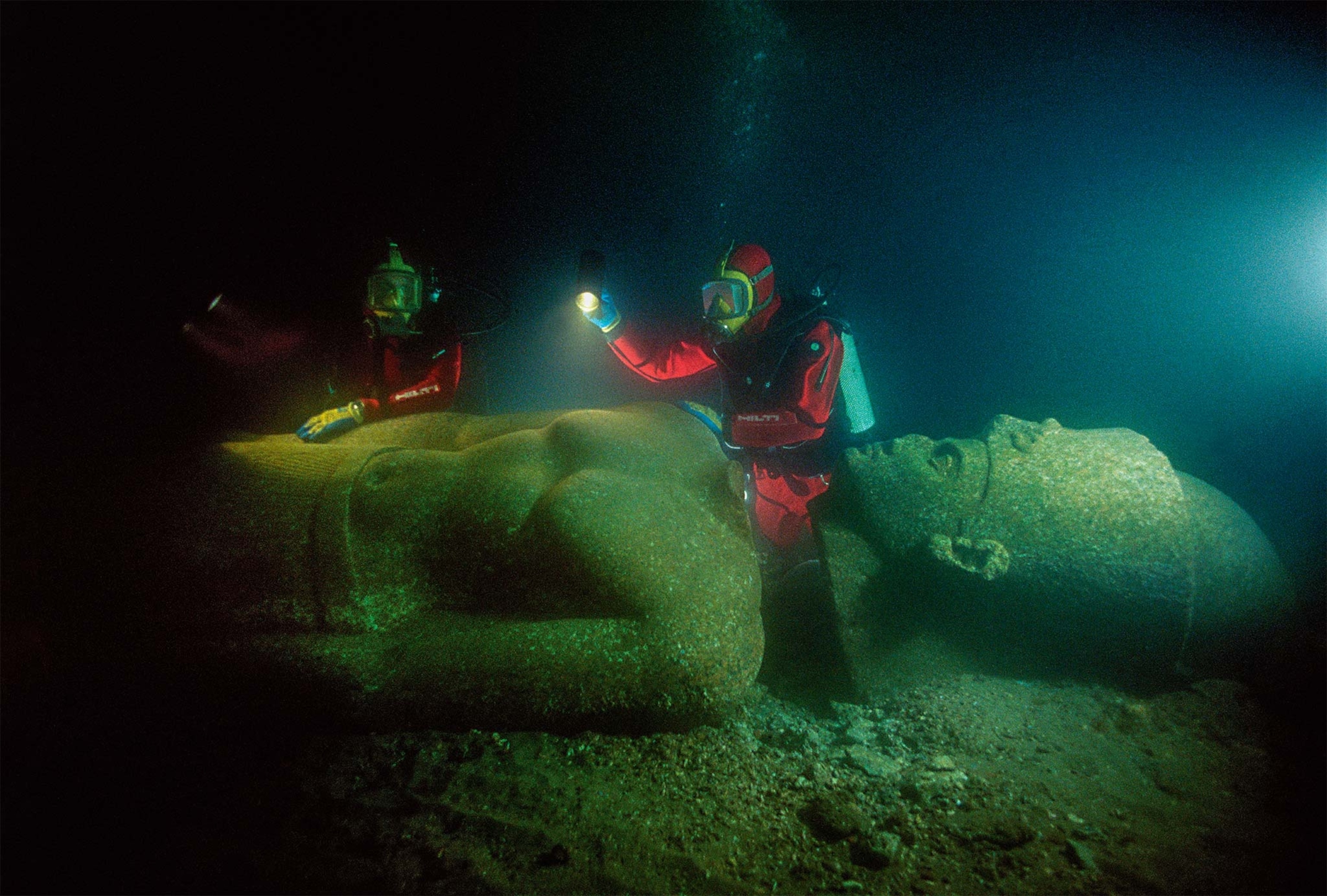
Thonis-Heracleion and Canopus: Egypt’s lost seaports
Two of Ancient Egypt's most important ports were drowned by the waters of Aboukir Bay some 1,200 years ago. Scholars believe that both Thonis-Heracleion and Canopus, located in the Nile Delta, fell victim to a combination of rising sea levels and chronic seismic activity that led to the liquefaction of the ground beneath them.
Rising to the challenge
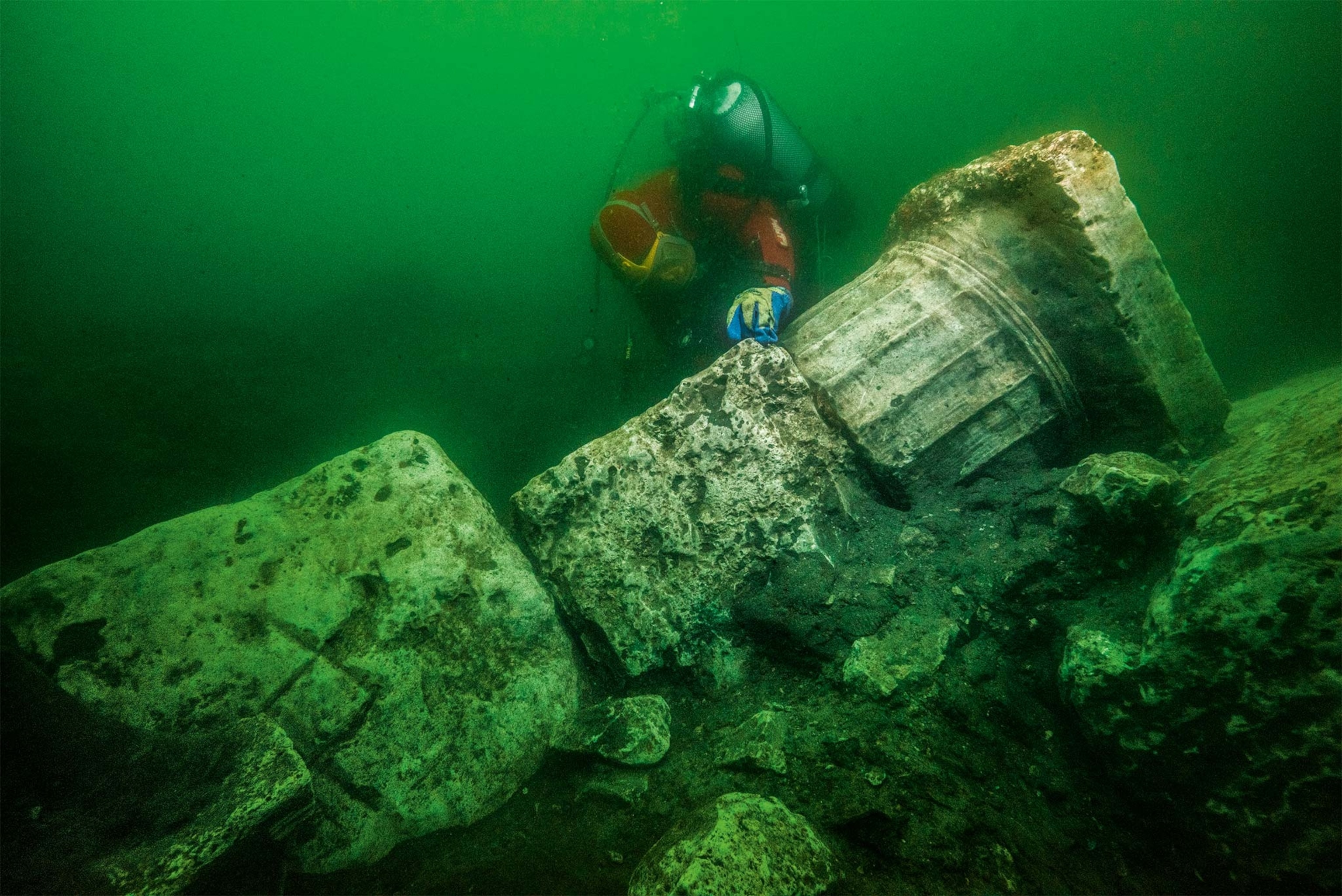
Thonis-Heracleion was one of Egypt’s most important port cities. It was a trading hub and a gateway for goods from all over the Mediterranean. Documented since the eighth century B.C., Thonis-Heracleion went into decline as Alexandria rose to importance in 331 B.C. In 2000 underwater archaeologist Franck Goddio and the European Institute for Underwater Archaeology located its ruins, including the famous temple of Amun-Gereb, with its outer walls and three colossal statues standing over 16 feet high at its entrance. More than two decades of archaeological research there have revealed many of the city’s secrets. Navigable canals, minor temples, the remains of numerous vessels, and hundreds of stone anchors confirm that this port was once a busy trading center for Greek merchants.
Canopus was an important spiritual center in Ptolemaic Egypt and home to a monumental temple for Serapis, a syncretic deity who blended traits from Greek and Egyptian gods. The city attracted pilgrims from all over the ancient world who came to Canopus to worship at the temple. In 1933 Egyptian scholar Prince Omar Toussoun conducted the first archaeological study of the site thanks to indications from fishermen and an English aviator. In 1999 Goddio’s team, who had been surveying the waters of Aboukir Bay, located the site and were able to confirm its identity as the lost city of Canopus.


Epidaurus: a home by the sea
Known worldwide for its magnificent theater, the Greek city of Epidaurus was one of the most important trading ports on the Argolid peninsula. In Roman times, various maritime villas were built along the coast here, taking advantage of the fertile land and easy access to the sea. Located outside the cities, these estates were dedicated to agriculture and the production of wine, oil, and garum, the fish sauce so highly prized by the Romans. The residents were hardworking, but their estates had a comfortable, even luxurious, domestic area that included baths and places for entertaining and recreation. In the fifth century A.D., a little more than a century after its construction, one of these villas was flooded by waters from the bay of Agios Vlasios after greater than normal seismic activity in the area and a general rise in sea level. In 1967 oceanographer Nicholas Flemming documented several submerged structures in the bay of Agios Vlasios. In 1971 the archaeologist Charalambos B. Kritzas identified what was known to the locals as the submerged city, which has turned out to be the remnants of a coastal Roman villa.
Sitting just 150 feet from the coast and at only 6.5 feet deep, the villa’s ruins consist of three spaces. One of them was a large storeroom and contains pieces of some 20 dolia—huge clay containers that were used to store and sometimes ferment large quantities of wine. Another space seems to have housed a winepress, and a third space may have been the baths.

You May Also Like


Go Further
Animals
- We finally know what caused Florida fish to spin in circles until they diedWe finally know what caused Florida fish to spin in circles until they died
- 5 clever animals that treat and prevent their own illnesses5 clever animals that treat and prevent their own illnesses
- What would the world look like without mosquitoes?What would the world look like without mosquitoes?
- Social media loves to villainize dolphins. Here's why it's wrong.Social media loves to villainize dolphins. Here's why it's wrong.
- How did wolves evolve into dogs? New fossils provide cluesHow did wolves evolve into dogs? New fossils provide clues
Environment
- This little bird tells the story of the East Coast’s disappearing marshesThis little bird tells the story of the East Coast’s disappearing marshes
- ‘Corn sweat’—and other weird weather phenomena—explained‘Corn sweat’—and other weird weather phenomena—explained
- A sea tornado sank a yacht. We might see them more often.A sea tornado sank a yacht. We might see them more often.
History & Culture
- Your favorite foods have surprising global originsYour favorite foods have surprising global origins
- How did ancient Egyptian obelisks end up all over the world?How did ancient Egyptian obelisks end up all over the world?
- What we’ve learned—and lost—since the Titanic wreck was foundWhat we’ve learned—and lost—since the Titanic wreck was found
- Did Babe Ruth really ‘call’ this legendary home run?Did Babe Ruth really ‘call’ this legendary home run?
- The real history behind the legend of China's Monkey KingThe real history behind the legend of China's Monkey King
Science
- 8 things we’ve learned about how alcohol harms the body8 things we’ve learned about how alcohol harms the body
- Is mouth taping the secret to a better night's sleep?Is mouth taping the secret to a better night's sleep?
- Mold is in your kitchen—and in places that might surprise youMold is in your kitchen—and in places that might surprise you
Travel
- This slave rebellion was almost lost to history–until nowThis slave rebellion was almost lost to history–until now
- Discover America's Oktoberfest capital: CincinnatiDiscover America's Oktoberfest capital: Cincinnati
- Here's what an astronaut has to say about space tourismHere's what an astronaut has to say about space tourism
- 4 of the best food experiences on Scotland's Isle of Skye4 of the best food experiences on Scotland's Isle of Skye
