May 24, 2024

Rinse and repeat: yet another wave of dangerous storms expected Saturday


One active pattern after another sweeping across the U.S. this season will just keep on going as we head into the start of the Memorial Day weekend.

The Storm Prediction Center (SPC) issued a moderate risk, a level 4 out of 5, for much of Oklahoma and Kansas on Saturday as widespread severe thunderstorms are expected to develop across the region.

"Strong to violent tornadoes" are possible, the SPC said in its forecast on Friday afternoon.

The Setup

Fresh on the heels of a low-pressure system that generated powerful tornadoes comes...yet another low-pressure system that could generate powerful tornadoes.

Forecasters expect a low to quickly develop and strengthen over the central Plains during the day Saturday.
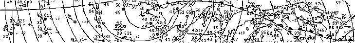
Image: Twister Data

Ample heat and humidity over the southern Plains, combined with lift provided by the approaching low and strong wind shear aloft, will set the stage for widespread severe thunderstorms from northern Texas through southern Nebraska.

The model graphic above from TwisterData.com is valid for about 7:00 p.m. CDT on Saturday, showing the Energy Helicity Index (EHI).

EHI is a parameter that takes into account both instability and wind shear. Values above 2.00 are sufficient for supercells, with higher values indicating a more favorable environment for supercells that could produce tornadoes. It's not hard to see how favorable the setup is for tornadic and hail-producing supercells on Saturday afternoon and evening across the areas highlighted by the SPC.

The worst of the weather is expected across much of Oklahoma, Kansas, and far western Missouri. This includes Oklahoma City, Tulsa, Wichita, and Kansas City.

The Risk


The SPC's moderate risk is in effect due to the potential for all modes of significant severe weather across the region. 

TORNADOES: A growing risk for intense and long-lived tornadoes will exist within any discrete supercell thunderstorms that form away from other clusters of storms. These supercells could also produce very large hail the size of golf balls or larger.

WINDS: As the evening wears on, and as we so often see, those individual thunderstorms will begin to merge into one or more squall lines that races east through the overnight hours. These lines will carry a risk for widespread damaging winds with gusts of 75+ mph possible. There is a risk for fast-moving embedded tornadoes within these squall lines. Damaging winds are a particular risk through areas like Tulsa, Wichita, and Kansas City.

TIMING: Thunderstorms will begin to bubble through the western half of the risk area during the day on Saturday. The greatest risk will evolve through the early evening hours, continuing into Saturday night and the wee morning hours Sunday.  

Safety Tips

Be proactive. Don't let storms take you by surprise. Keep an eye on the radar and local news for live storm coverage, and stay aware of storms heading in your direction.

Make sure you have a way to receive severe weather warnings the moment they're issued. Take a look at your phone and ensure emergency alerts are turned on for tornado warnings. These free push alerts are proven lifesavers, and they only warn you if your location is included in the warning so you know it's nothing to ignore. 

Do not rely on tornado sirens as your first line of defense. Tornado sirens are not meant to be heard indoors. These systems are unreliable and prone to failure.


Form a plan in advance for where you'll seek shelter if you're under a tornado warning. Stay on the lowest level of the building in an interior room, putting as many floors and walls between you and flying debris as possible. Keep blankets, pillows, and a bicycle helmet handy to wear while sheltering. 

Manufactured and mobile homes offer no protection from even the weakest tornado. If you're in one of these unsafe structures, have a secondary shelter location in mind and go there before the storms arrive.

Wear closed-toe shoes today to protect your feet if you have to walk through debris.

If you're driving when a tornado warning is issued, do not stop under an overpass. Bridges offer no protection from tornadic winds or flying debris—they actually make the winds stronger. Stopping under a bridge to shelter from a tornado or large hail often causes traffic jams that can lead to serious car accidents or worse if a tornado hits that location.


Follow me on Facebook | Bluesky | Threads | Instagram | Twitter

Get in touch! Send me an email.

Please consider subscribing to my Patreon. Your support helps me write engaging, hype-free weather coverage—no fretting over ad revenue, no chasing viral clicks. Just the weather.


May 20, 2024

Severe storms may produce strong tornadoes in the Midwest on Tuesday


An active spring severe weather season rolls on across the central United States this week as a multi-day storm threat unfolds over the region. 

Tuesday looks to feature the strongest and most widespread storm risk, with severe storms targeting the eastern Plains and Midwest through the day.

The Setup

A model image showing the upper levels of the atmosphere on Tuesday morning. || Image: Tropical Tidbits

The country is split in two right now between a ridge over the southern and eastern U.S. and a broad trough over the west. This setup is the driving force behind the warmth and the storm risk we'll see through the week.

It's going to be a hot week for much of the country as daytime highs frequently soar into the 80s and 90s beneath that ridge from the desert southwest all the way into interior New England. 


Meanwhile, the trough out west will force the development of a low-pressure system over the central Plains on Monday. This storm will quickly gather strength as it moves north toward Iowa and Minnesota through the day on Tuesday.

Widespread thunderstorms are expected to develop as the low and its fronts send unstable air surging skyward. This low will drag a slug of warm and humid air north into the Midwest, feeding thunderstorms the fuel they need to survive and thrive. Plenty of wind shear aloft will allow these storms to quickly turn severe. 

The Storm Prediction Center issued an enhanced risk for severe weather—a level 3 out of 5—for a wide swath of the Midwest from central Missouri to northern Wisconsin. The overall risk for severe weather covers much of the central U.S. from Dallas north toward the international border across the Great Lakes.

Like so many severe weather events of this caliber, the storms will unfold in different stages throughout the day. Discrete thunderstorms early in the day could turn into supercells capable of supporting tornadoes in addition to the risk for large hail and damaging wind gusts.


The greatest risk for tornadic supercells exists in the warm airmass southeast of the low's center, which is likely to fall over the eastern half of Iowa, extending into portions of Wisconsin, Illinois, and Missouri. Dynamics are favorable for one or two strong, long-lived tornadoes in this region.

As the afternoon and evening wear on, storms will start to merge and congeal into one or more squall lines, at which point the main threat will transition over to damaging straight-line winds with the potential for embedded tornadoes. These storms will likely continue well into the nighttime hours as they race east into the Great Lakes region.

Image: NWS Mobile

Nighttime severe thunderstorms are particularly dangerous because it's easy to miss warnings as we tune out and wind down for the evening. Don't let storms take you by surprise. Make sure you have a way to receive severe weather warnings the moment they're issued.

Take a look at your phone and ensure emergency alerts are turned on for tornado warnings. These free push alerts are proven lifesavers, and they only warn you if your location is included in the warning so you know it's nothing to ignore. 

Do not rely on tornado sirens as your first line of defense. Tornado sirens are not meant to be heard indoors. These systems are unreliable and prone to failure. 


Follow me on Facebook | Bluesky | Threads | Instagram | Twitter

Get in touch! Send me an email.

Please consider subscribing to my Patreon. Your support helps me write engaging, hype-free weather coverage—no fretting over ad revenue, no chasing viral clicks. Just the weather.


May 6, 2024

Intense tornadoes possible Monday as rare 'high risk' kicks off a week of severe storms


"Multiple intense, long-track tornadoes" are possible across parts of the southern Plains on Monday as another major severe weather outbreak unfolds across the center of the country.

This is the opening act of another multi-day severe weather threat across the country, the latest in a weeks-long run of severe weather that's hammered the central U.S. over the past few weeks.

Note: The outlook maps in this article were updated at 2:30 p.m. CDT Monday to reflect the SPC's latest forecast.

The Storm Prediction Center (SPC) upgraded portions of Oklahoma and Kansas to a rare high risk for severe weather, the highest threat category that's reserved for days capable of producing a tornado outbreak. This is the first high risk issued by the SPC in more than a year.

All the dynamics are in place to support dangerous storms Monday afternoon and into the nighttime hours. High instability and favorable wind shear will allow any storms that form to quickly intensify and turn severe.


Widespread storms are likely to develop from Nebraska through Oklahoma on Monday afternoon. Storms farther to the north are likely to congeal into one or more squall lines capable of producing damaging winds of 60+ mph, along with a risk for embedded tornadoes.

Farther south, though, storms are likely to develop as individual supercells across southern Kansas and much of central Oklahoma. Forecasters are concerned about the dynamics they see in this area, warranting the upgrade to a high risk.

Any supercells that form in the region could be capable of supporting intense, long-track tornadoes, as well as hail up to the size of softballs, and destructive wind gusts of 75+ mph.

As the evening wears on, those supercells will likely merge into a squall line and truck east after dark, posing a significant risk for damaging wind gusts and embedded tornadoes across eastern sections of the risk areas. Nocturnal severe thunderstorms are especially risky as folks tune out and head to bed. 

Image: SPC

High risk days are rare and dangerous. Forecasters reserve this designation for the most significant days that have the highest potential for storms that could cause significant damage and loss of life.

It's rare for all the ingredients to come together to create a high-end severe weather outbreak. Lots of points of failure are possible. Storms could struggle to form. We could see "messy" storm structures that prevent them from fully engaging with the favorable environment. But the risk is there—and it's serious.

Please take today seriously if you live in the area. If you know folks in the area, make sure they're aware of the risk on Monday. 

Some Safety Tips

Be proactive. Don't let storms take you by surprise. Keep an eye on the radar and local news for live storm coverage, and stay aware of storms heading in your direction.

Make sure you have a way to receive severe weather warnings the moment they're issued. Take a look at your phone and ensure emergency alerts are turned on for tornado warnings. These free push alerts are proven lifesavers, and they only warn you if your location is included in the warning so you know it's nothing to ignore. 

Do not rely on tornado sirens as your first line of defense. Tornado sirens are not meant to be heard indoors. These systems are unreliable and prone to failure. 

Image: NWS Mobile

Form a plan in advance for where you'll seek shelter if you're under a tornado warning. Stay on the lowest level of the building in an interior room, putting as many floors and walls between you and flying debris as possible. Keep blankets, pillows, and a bicycle helmet handy to wear while sheltering. 

Manufactured and mobile homes offer no protection from even the weakest tornado. If you're in one of these unsafe structures, have a secondary shelter location in mind and go there before the storms arrive.

Wear closed-toe shoes today to protect your feet if you have to walk through debris.

If you're driving when a tornado warning is issued, do not stop under an overpass. Bridges offer no protection from tornadic winds or flying debris—they actually make the winds stronger. Stopping under a bridge to shelter from a tornado or large hail often causes traffic jams that can lead to serious car accidents or worse if a tornado hits that location.

Tuesday's Threat


Tuesday's severe weather outlook begins at 7:00 a.m. EDT. This threat will play out in two regions.

First, Monday's severe weather will continue through the overnight hours as the squall line pushes east into the Mississippi Valley through the pre-dawn hours on Tuesday. This covers the risk near the Mississippi River.

Later in the day, a broken line of thunderstorms is likely to develop along the cold front as it tracks east through the Midwest and Ohio Valley. The strongest of these storms will be capable of producing damaging wind gusts and a couple of isolated tornadoes.

Wednesday's Threat


A new low-pressure system will develop in Texas and quickly scoot toward the Midwest by the middle of the week, leading to a renewed threat for widespread severe thunderstorms on Wednesday.

This expansive risk stretches from central Texas to western Massachusetts, with the bulk of the severe weather expected from the Dallas metro area up through the heart of the Ohio Valley.

Widespread damaging wind gusts of 75+ mph will be possible in and around the enhanced risk area on Wednesday, along with a potential for a few strong tornadoes. Scattered severe storms are possible for folks in the eastern states, as well, with damaging winds possible in the stronger storms that develop.

Initial thunderstorms could start as supercells west of the Mississippi early in the day Wednesday. The threat will likely evolve as multiple broken squall lines through the day, with embedded supercells possible. 


Follow me on Facebook | Bluesky | Threads | Instagram | Twitter

Get in touch! Send me an email.

Please consider subscribing to my Patreon. Your support helps me write engaging, hype-free weather coverage—no fretting over ad revenue, no chasing viral clicks. Just the weather.


April 27, 2024

Second Tornado Outbreak Expected On The Plains Saturday


All signs point to a second tornado outbreak developing across the southern and central Plains on Saturday as a multi-day severe weather event unfolds over the region.

A moderate risk for severe weather—a 4 out of 5 on the scale measuring the threat for severe thunderstorms—is in place for much of Oklahoma and portions of northern Texas and southeastern Kansas. 

Multiple violent, long-lived tornadoes are possible from Texas north toward Iowa, including major cities like Dallas, Oklahoma City, Wichita, Kansas City, and Omaha. Severe storms will also be capable of producing hail larger than golf balls and destructive wind gusts of 75+ mph.

Storms were already developing on the western edge of the risk areas as of this post's publication around 11:30 a.m. CDT. We'll see thunderstorms increase in coverage and intensity through the afternoon, with the greatest threat pushing into the moderate risk area through the late-afternoon and early evening hours. 


Saturday's severe weather follows a horrible tornado outbreak that struck the central Plains on Friday, including more than a dozen confirmed tornadoes. The worst storms hit Nebraska, where multiple violent and long-track tornadoes tore through communities in the central and eastern portions of the state.

One of the tornadoes near Lincoln, Nebraska, was caught on a traffic camera on I-80 as the storm roared across the highway. Forecasters will survey the damage once conditions settle down, and it's likely that a few of the twisters will receive high-end ratings on the Enhanced Fujita Scale.


The big news from Friday's storms, though, is the fact that there were apparently zero fatalities amid all the damage. It's a miracle of modern science and warning technology that multiple intense twisters levelled neighborhoods and—at least as of now—nobody died. 

Friday's warning success story is a testament to the power of tornado warnings and good weather communications. A more widespread outbreak on Saturday makes it even more important to ensure you have a way to receive severe weather warnings the moment they're issued.

Ensure emergency alerts are activated on your phone for tornado warnings. These free push alerts pop up on your phone the moment your location is placed within a tornado warning. The alerts are geotargeted to only alert you if you're in the warning polygon—you'll only get it if you're in danger.

It's important to have multiple ways to receive alerts in case one method gets delayed or outright fails. Keep tabs on the radar so you know what's coming in advance.

Take a look at the weather apps on your phone and make sure they're set to deliver tornado warnings for your current location. Local television news will run wall-to-wall coverage when tornado warnings are in effect. Most stations run livestreams online if you don't have cable or antenna. 


Follow me on Facebook | Bluesky | Threads | Instagram | Twitter

Get in touch! Send me an email.

Please consider subscribing to my Patreon. Your support helps me write engaging, hype-free weather coverage—no fretting over ad revenue, no chasing viral clicks. Just the weather.


April 6, 2024

Severe thunderstorms might blot out the eclipse for parts of the U.S.


A long-duration spell of rainy, stormy weather will cover much of the southern United States through the upcoming week, kicking off with a round of severe thunderstorms on the southern Plains on Monday.

Did you know there's also a total solar eclipse happening on Monday? I know! They kept that secret really well.


It's going to be a strange day across the area as thunderstorms are expected to coincide with the moon's shadow as it passes over the region, blotting out the sun for several minutes along the path of totality.

Some lucky folks in Texas, Oklahoma, and Arkansas will see three to four full minutes of night-like darkness at the peak of the eclipse early Monday afternoon, complete with colors on the horizon that make it appear as if you're surrounded by a 360° sunset.

Millions of visitors are flocking to the path of totality across the U.S. and Canada hoping to catch a glimpse of the special moment. Darkness descends regardless of cloud cover, but folks who manage to see the total eclipse amid clear skies will experience a once-in-a-lifetime moment.

The position of the total solar eclipse in five-minute increments, overlaid on the SPC's severe weather outlook for Monday.

But those pesky clouds are likely going to get in the way for much of the eclipse's track across the southern U.S.

A trough digging across the southern Rockies to begin the week will kick off a round of strong to severe thunderstorms throughout the southern Plains. Widespread severe weather is expected through Monday afternoon and evening, according to the Storm Prediction Center. Much of the action will focus on Texas, with a risk for severe storms spilling into neighboring states.

Damaging wind gusts and "very large" hail are the predominant risks with Monday's storms, the SPC said in its outlook on Saturday. This is a little riskier than normal given the number of people visiting the region. The risk for traffic jams is bad news on a normal severe weather day, let alone when there's a hailstorm during a mass exodus.


View-wise, it's not the end of the world if your view of the eclipse is obscured by clouds. Storms popped up here in North Carolina during the August 2017 eclipse. We had 94 percent coverage of the sun at the peak of the eclipse, and I could still see the crescent sun through the storm clouds that day.

If nothing else, this will be an interesting case study for how the eclipse affects active weather. I wrote a bit about how eclipses affect the weather for The Weather Network last year.

Temperatures noticeably drop along the path of totality, so much so that we see fair-weather cumulus clouds dissipate for several hours in the wake of the moon's shadow. The temporary loss of daytime heating may have a tiny effect on any thunderstorms ongoing during totality.


Looking beyond the eclipse, stormy weather will continue throughout the week as a robust and slow-moving low-pressure system develops.

Aside from the risk for more rounds of  severe thunderstorms, we could see a threat for widespread flooding 3-5+ inches of rain falls on a huge swath of the south and Ohio Valley through the end of the week.


Follow me on Facebook | Bluesky | Threads | Instagram | Twitter

Get in touch! Send me an email.

Please consider subscribing to my Patreon. Your support helps me write engaging, hype-free weather coverage—no fretting over ad revenue, no chasing viral clicks. Just the weather.


April 1, 2024

Widespread severe thunderstorms expected overnight into Tuesday


We're in the midst of the first widespread severe weather outbreak of the season across a large swath of the central United States as a feisty low-pressure system cuts across the region.

The Storm Prediction Center issued a moderate risk—a 4 out of 5 on the scale measuring the risk for severe weather—for Oklahoma on Monday and again for much of Ohio on Tuesday. These are the first moderate risks issued anywhere in the U.S. since August 7 of last year.

All modes of severe weather are likely with the storms that fire up over the next couple of days. We've already seen multiple severe thunderstorms roll across the southern Plains and the Midwest on Monday, with plenty of large hail and a few reported wind gusts of 70+ mph.

The Setup

The hubbub is the result of a low-pressure system trucking across the central Plains tonight. This low will continue strengthening as it heads toward the Great Lakes into Tuesday.

The Weather Prediction Center's surface forecast for Tuesday afternoon.

It's the classic springtime severe weather setup. A steady stream of warm, humid air flowing out of the Gulf will provide ample fuel for thunderstorms to flourish as this system moves through the region.

Upper-level winds are favorable for thunderstorms to quickly turn severe, growing into both supercell thunderstorms and robust squall lines.

Safety Tips

This is our first widespread severe weather outbreak in a while. Anxiety is high, made worse by social media storm enthusiasts who treat it like an adrenaline sport.

Not everyone under the risk for severe weather will get hit by severe weather. Keep an eye on the radar, look out for severe weather alerts, and have a plan ready to take shelter from bad storms whether you're at home, work, school, or even the grocery store.

Strong winds are the single greatest threat to safety during severe weather—almost entirely due to trees blowing into homes and vehicles. If you live in an area at risk for overnight severe weather, please consider sleeping in a room where trees or tree limbs don't loom outside. 

Make sure you have a way to receive severe weather alerts when you're asleep, and ensure that emergency alerts for tornado warnings are activated on your smartphone. These noisy push alerts can provide critical moments of heads-up before bad weather arrives.

Round One: Monday Night into Tuesday


Our first round of storms was already in progress by the time this post went live around 8:30 p.m. Eastern on Monday.

Multiple supercells in Texas, Oklahoma, and Kansas left behind large hail and wind damage in their wake. Supercells are thunderstorms with rotating updrafts, a feature that makes these storms resilient and capable of producing more intense severe weather.

As we so often see during these outbreaks, these supercell thunderstorms will eventually merge into a long, broken squall line that'll chug east through the overnight hours. 

Forecasters expect these storms to continue producing widespread severe weather across Missouri, Arkansas, and Illinois overnight Monday and into early Tuesday morning.

A model image showing a potentially severe squall line around 2:00 a.m. CDT on Tuesday. (WSV3)

The main threat with the overnight squall lines will be damaging straight-line winds, with many of the storms capable of producing significant wind gusts of 75+ mph. These storms will push east through early Tuesday morning, likely reaching Indiana and Ohio in time for the morning commute.

There's also a risk for tornadoes embedded in these squall lines—you'll sometimes hear them called "QLCS tornadoes," taking their name from the technical term for a squall line. These tornadoes happen quickly and often with reduced tornado warning lead time.

Round Two: Tuesday


We'll see the low-pressure system moving into the lower Great Lakes during the day Tuesday, dragging a cold front into a vast plume of warm, humid air parked over the region.

Forecasters expect the atmosphere to recover from Tuesday morning's storms in time for a fresh round of severe thunderstorms to build over the Ohio Valley and Mid-South by the afternoon hours.

A model image showing the general areas where we might see severe storms around 5:00 p.m. EDT Tuesday. (WSV3)

The strongest thunderstorms are likely over eastern Indiana and much of Ohio covered by the moderate risk. Dynamics here are favorable for supercells that would be capable of producing tornadoes—some of which could be strong and long-lived—as well as hail larger than golf balls and damaging wind gusts.

Farther south, storms are likely to form into one or more squall lines as they push through Kentucky, Tennessee, and northern Alabama. Damaging winds and embedded tornadoes would be the predominant threats with these storms. 

The risk for severe weather will continue pushing east overnight Tuesday into Wednesday, with severe storms possibly crossing the Appalachians and heading into the Virginias and Carolinas. Damaging winds and an isolated tornado would be the main threat with these remaining storms.

[Satellite image via NOAA]


Follow me on Facebook | Bluesky | Threads | Instagram | Twitter

Get in touch! Send me an email.

Please consider subscribing to my Patreon. Your support helps me write engaging, hype-free weather coverage—no fretting over ad revenue, no chasing viral clicks. Just the weather.


November 19, 2023

Classic fall storm could bring the southeast strong tornadoes, beneficial rains


A classic fall storm revving up across the central United States this week could bring severe thunderstorms to the southeast—along with beneficial rains for areas falling into a pretty serious drought over the past couple of months.

Some of the severe thunderstorms on Monday could grow quite strong across Louisiana and Mississippi, bringing a risk for a couple of strong, long-lived tornadoes.

Fall severe weather season ramps up

'Tis the season for severe weather in the south, and this looks to be our first real "second season" severe weather outbreak of the year. November and December see a noticeable uptick in severe weather across the southeast as powerful low-pressure systems develop over the Plains and roll north toward the Great Lakes.

Warm, humid air streaming north out of the Gulf of Mexico provides the instability, while the storm and its fronts provide the lift and wind shear needed to push the resulting thunderstorms beyond severe limits.

The Storm Prediction Center issued an enhanced risk for severe weather across northern Louisiana and much of southern and central Mississippi during the day Monday. Thunderstorms will develop during the afternoon and sweep across the region from west to east.


All modes of severe weather are possible, but the headline (as always) is the risk for tornadoes. Forecasters see enough instability and wind shear that a couple of those tornadoes could be strong or long-lived in and around the enhanced risk area.

Aside from the tornado risk, any of the thunderstorms that bubble over the region on Monday could produce strong wind gusts of 60+ mph, as well as a risk for large hail.

Make sure you have a way to get warnings

It's been a long while since we've had to contend with a risk for severe weather. Make sure emergency alerts are activated on your phone so you'll know the moment a tornado warning is issued for your location. Make a mental note of all the safe places at home, work, school, and various places you run errands in case dangerous weather strikes during the day.

Much of the severe weather threat on Monday and early Tuesday will unfold after sunset. Severe weather is especially dangerous after dark as people tune out and wind down for the evening. It's more important this time of year than ever to stay weather-aware, keeping up with storms nearby and having a way to receive warnings as soon as they're issued.

Remember—never rely on tornado sirens as your first line of defense. These sirens are outdoor warning systems not meant to be heard indoors, and they're prone to failure in bad weather.

A taste of beneficial rains on the way


Even with the threat for severe weather, the widespread rain we'll see over the next couple of days is welcome news for just about everyone in the region.

Much of the south has slipped into severe or extreme drought over the past couple of months as dry patterns prevailed and tropical systems largely avoided making landfall on the northern Gulf Coast.


Some areas have seen their annual rainfall totals fall more than a foot behind where they should be by the middle of November. It'll take a lot of rain to ameliorate the growing effects of this extended drought, but even an inch or two of rain is a welcome step in the right direction.

Another low-pressure system could develop in the western Gulf of Mexico late in the week around Thanksgiving, which could bring another quick hit of rain to areas that desperately need the water. Beyond that, we could be in for another dry pattern that'll likely last into the opening days of December.


Follow me on Facebook | Bluesky | Threads | Instagram | Twitter

Get in touch! Send me an email.

Please consider subscribing to my Patreon. Your support helps me write engaging, hype-free weather coverage—no fretting over ad revenue, no chasing viral clicks. Just the weather.


August 6, 2023

Widespread severe storms with high winds to sweep across the eastern U.S. on Monday


Well, that's strange.

It's a little unusual to see such a sprawling risk for severe weather as we approach the middle of August, but a robust system swinging into the eastern United States will trigger multiple lines of severe storms through the day on Monday.

The Storm Prediction Center issued a very large enhanced risk for severe weather—a level 3 out of 5 on the scale measuring the risk for severe storms—stretching from Birmingham to Philadelphia.

Plenty of hot, muggy air parked over the eastern states will provide the fuel needed for thunderstorms to roar through the day Monday, largely sparked by a cold front advancing into this summertime airmass.


Forecasters expect enough instability and wind shear for these storms to organize in a hurry and turn severe. Far and away the greatest threat with these storms will be damaging wind gusts. We're likely to see the storms develop into numerous squall lines, with each one likely capable of producing 60+ mph wind gusts as they push through.

Storms will likely form west of the Appalachians by the early afternoon Monday, steadily pushing east through the late afternoon and evening hours.

The SPC's forecast on Sunday showed a very large area at risk for damaging wind gusts on Monday, with the greatest threat concentrated on the I-85/95 corridor from Birmingham north through the Philly area. There's a decent chance that the strongest storms could approach the D.C. metro area through Monday afternoon and evening.


There's a chance that some of the discrete thunderstorms—the loners that form on their own, away from the interference of nearby storms—could develop some rotation, bringing with them a threat for large hail and possibly a tornado or two.

We could also see little 'kinks' develop along the leading edge of some of the squall lines, bringing the potential for a quick tornado or two embedded within the stronger lines of storms.

Things will calm down once the cold front pushes through, and most folks across Tennessee/North Carolina and northward should enjoy a touch of lower humidity on Tuesday and Wednesday.

A climatology map showing where damaging winds in severe thunderstorms are common on August 7 in any given year. (SPC)

So...why is this strange, exactly? 

August is usually the doldrums when it comes to weather east of the Mississippi River. Around this time of year, the jet stream is typically all the way north in Canada, allowing any low-pressure systems to swirl through the Plains before lifting north of the international border.

That relative lack of an active pattern leaves the eastern third of the country to the whims of tropical systems in the Atlantic or pop-up thunderstorms fueled by daytime heating—those random storms that bubble up where they may, raging for an hour before fizzling out with the loss of sunlight.

But the pattern over the U.S. and Canada in recent weeks has allowed these robust systems to track farther south than they normally would, essentially creating a setup where we have May-like storm systems tracking into the full-blown August heat.


Follow me on Facebook | Bluesky | Threads | Instagram | Twitter

Get in touch! Send me an email.

Please consider subscribing to my Patreon. Your support helps me write engaging, hype-free weather coverage—no fretting over ad revenue, no chasing viral clicks. Just the weather.


June 17, 2023

Dangerous heat, dangerous storms continue as bizarre pattern persists


Dangerous weather will continue rolling through the weekend and into next week as a freaky pattern for the middle of June stubbornly holds out over the southern United States.

Additional rounds of powerful storms will persist over the next couple of days, alongside an unseasonable slug of unbearable heat parked over Texas.

Day after day of severe thunderstorms have put tremendous stress on the southern states this past week. We've had deadly tornadoes, tremendous amounts of destructive hail, flash flood emergencies, and widespread wind damage as one wave of destructive storms after another swept from the southern Plains to the northern Gulf Coast.

SOURCE: Twister Data

All of the hubbub is the result of a subtropical jet stream locked over the region, the result of a very strong upper-level ridge of high pressure standing tall over Mexico.

Beneath the ridge, extremely hot and humid temperatures have bathed much of Mexico and Texas in recent days, with daytime highs easily exceeding 100°F and heat indices climbing to 110-115+ during the day.

This heat will continue into next week, with highs in the 100s a common sight across much of southern and southeastern Texas into the middle of next week. It's not bad enough that the days are so incredibly hot—it's that the extreme humidity is preventing nights from providing any relief at all. 


Dew points in the upper 70s are preventing nighttime lows from dipping much below 77-80°F.

Heat waves like this are compounding disasters. Folks without access to air conditioning rely on nights for some relief from the unbearable heat.

One or two days is survivable, but when you get into 5+ days of stifling days and putrid nights, it will start to take a significant physical toll on vulnerable individuals. 


The outer edge of that heat dome parked over Texas is serving as the focus for all of those rowdy thunderstorms we've seen all week. We typically don't see such a dynamic setup in the south this late in the year. The combination of summertime temperatures with a springtime severe weather setup has resulted in violent thunderstorms, an adjective that seems like it's an understatement.

Extreme instability has fueled raucous thunderstorms that are able to organize and intensify thanks to that unusual wind shear present over the region.


During more normal times, these storms would just be those typical summertime drenchers that pop up during the day and fizzle out around sunset. That wind shear has allowed these storms to structure themselves into hail-churning wind machines, with golfball size hail and 70+ mph wind gusts a common sight.

The Storm Prediction Center highlights additional risks for severe weather on Saturday, Sunday, and Monday, covering the exact same areas battered by relentless storms since early this past week.

We'll finally start to catch a break on all fronts by the middle of the week, thankfully, as the pattern breaks and allows that ridge to weaken. This long-deserved progression in the upper levels of the atmosphere will allow the heat to subside to a more seasonable muck over Texas, while defusing the turbocharged environment that's allowed terrible storms to flourish.

[Top Image: A water vapor image of the U.S. on June 17, 2023, highlighting the ridge over the south responsible for all the nonsense of late, via NOAA.]


You can follow me on Facebook, Mastodon, Twitter, Instagram, or send me an email.

Please consider subscribing to my Patreon. Your support helps me write engaging, hype-free weather coverage—no fretting over ad revenue, no chasing viral clicks. Just the weather.