Nunavut
Our editors will review what you’ve submitted and determine whether to revise the article.
News •
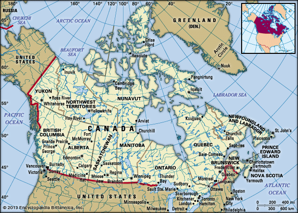
Nunavut, vast territory of northern Canada that stretches across most of the Canadian Arctic. Created in 1999 out of the eastern portion of the Northwest Territories, Nunavut encompasses the traditional lands of the Inuit, the indigenous peoples of Arctic Canada (known as Eskimo in the United States); its name means “Our Land” in Inuktitut, the language of the Inuit. The capital is Iqaluit, at the head of Frobisher Bay on southern Baffin Island.
The Arctic Ocean bounds Nunavut to the north, Greenland (separated from it by a series of narrow straits, Baffin Bay, and Davis Strait) lies to the east, and Quebec adjoins it to the southeast across Hudson Strait and the northeastern arm of Hudson Bay. Its only land boundaries are with Manitoba to the south and the Northwest Territories to the southwest and west. Nunavut constitutes the greater part of the Canadian Arctic Archipelago, including its largest island, Baffin Island. In addition, several islands are divided between Nunavut and the Northwest Territories (notably Victoria and Melville islands), and Nunavut’s territory extends to numerous islands in Hudson Bay, such as the Belcher Islands. Area 808,185 square miles (2,093,190 square km). Pop. (2021) 36,858; (2023 est.) 40,817.
- Capital:
- Iqaluit
- Population:
- (2021) 36,858; (2023 est.) 40,817
- Date Of Admission:
- 1999
- Territorial Motto:
- "Nunavut saginivut (Nunavut, our strength)"
- Territorial Flower:
- purple saxifrage
- Seats In House Of Commons:
- 1 (of 308)
- Time Zone:
- Pacific (GMT − 8 hours)
- Premier:
- P.J. Akeeagok (no political affiliation)
- Total Area (Sq Km):
- 2,093,190
- Total Area (Sq Mi):
- 808,185
Land
Relief and drainage
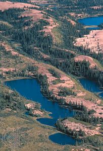
Nunavut comprises two distinct physiographic regions: the Canadian Shield, including the mainland and the islands around Hudson Bay, and the Arctic Archipelago in the north. The flat, often poorly drained lowlands of the Canadian Shield are underlain with ancient rock more than 1 billion years old. Thousands of lakes dot the heavily glaciated surface. The Arctic Archipelago consists of lowlands in the south that rise to the Innuitian Mountains in the north and along the eastern side of Baffin Island. Barbeau Peak, on northern Ellesmere Island, is the territory’s highest point, reaching an elevation of 8,583 feet (2,616 metres). Much of the archipelago is permanently covered in snow and ice, especially in the north and east.
Climate
The territory lies entirely within the Arctic climatic zone, with bitterly cold winters and cool to cold summers. Average daily January temperatures rise above −22 °F (−30 °C) only in the eastern coastal areas, and in the far north and northwest of Hudson Bay they reach only −31 °F (−35 °C). Average temperatures in July above 50 °F (10 °C) are limited to the area west of Hudson Bay, while in the far north and along the northeastern coast of Baffin Island they do not exceed 41 °F (5 °C). Precipitation is scant throughout most of the territory and falls almost entirely as snow. Annual precipitation levels of less than 8 inches (200 mm) gradually increase toward the east; the greatest amounts—more than 24 inches (600 mm)—occur on Bylot Island, just north of Baffin Island. Continuous permafrost underlies virtually the entire territory.
Plant and animal life
Nunavut lies above the northern limit of tree growth, and the timberline—which trends northwest-southeast just within the Northwest Territories and roughly parallels the border with Nunavut—is the traditional boundary between the cultural areas of the Inuit to the north and the northern American Indians (First Nations) known as Dene to the south. Tundra vegetation consists of lichens, mosses, a variety of flowering plants, and small, hardy shrubs, notably dwarf birches. The plant life supports small mammals, caribou, and musk oxen. Land predators include red and Arctic foxes, wolves, and grizzly bears. Seals, walrus, and polar bears inhabit the coasts, while beluga and bowhead whales and narwhals are found in coastal waters. During the summer months the tundra is plagued by mosquitoes and other biting insects, and millions of migratory aquatic birds nest in the territory; only a few birds live there year-round, notably the snowy owl and gyrfalcon and species of ptarmigan.

People
Population composition
The Inuit constitute more than four-fifths of Nunavut’s population; nearly all of the rest are of European descent. The language of the Inuit, Inuktitut, consisting of several dialect groups, is spoken widely. It has two writing systems: roman letters and a syllabic system developed in the 19th century by European missionaries. The territorial government recognizes Inuinnaqtun, an Inuktitut dialect spoken in western Nunavut and written in roman letters, as one of the territory’s four main languages (Inuktitut, English, and French are the other three).
The origins of the Inuit are obscure, but people have been living in the Canadian Arctic Archipelago for more than 4,000 years. The several dialect groups now present in Nunavut are all apparently descended from what is known as the Thule culture, a prehistoric maritime society. Thule peoples first arrived in what is now Nunavut about 1,000 years ago. Traditionally, the Inuit relied on trapping, hunting, and fishing for clothing and food; they lived in igloos, semisubterranean houses, or animal-skin tents.
Early contacts with explorers and whaling crews introduced new diseases and reduced the population during the 19th century. The fur trade was not well established in the Arctic until early in the 20th century, but the Inuit adapted quickly to it, and they, like the Dene, came to depend on outside sources for most of the necessities of life. Construction activity during World War II and in the postwar years further affected their way of life. The Inuit adapted readily to the opportunities for casual employment, and many were quick to abandon their seminomadic trapping and hunting existence for life in the settlements. Canadian government policy in the 1950s and ’60s promoted that trend.


