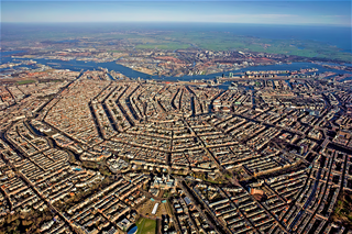
Amsterdam is the capital and most populated city of the Netherlands. It has a population of 921,402 within the city proper, 1,457,018 in the urban area and 2,480,394 in the metropolitan area. Located in the Dutch province of North Holland, Amsterdam is colloquially referred to as the "Venice of the North", for its large number of canals, now a UNESCO World Heritage Site.
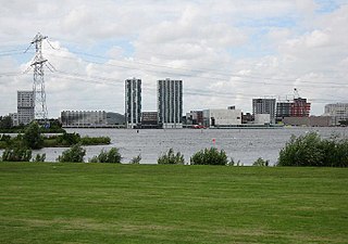
Almere is a planned city and municipality in the province of Flevoland, Netherlands across the IJmeer from Amsterdam.
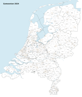
Since 1 January 2023, there have been 342 regular municipalities and three special municipalities in the Netherlands. The latter is the status of three of the six island territories that make up the Dutch Caribbean. Municipalities are the second-level administrative division, or public bodies, in the Netherlands and are subdivisions of their respective provinces. Their duties are delegated to them by the central government and they are ruled by a municipal council that is elected every four years. Municipal mergers have reduced the total number of municipalities by two-thirds since the first official boundaries were created in the mid 19th century. Municipalities themselves are informally subdivided into districts and neighbourhoods for administrative and statistical purposes.
The Government of Amsterdam consists of several territorial and functional forms of local and regional government. The principal form of government is the municipality of Amsterdam, Netherlands. The municipality's territory covers the city of Amsterdam as well as a number of small towns. The city of Amsterdam is also part of several functional forms of regional government. These include the Waterschap of Amstel, Gooi en Vecht, which is responsible for water management, and the Stadsregio of Amsterdam, which has responsibilities in the areas of spatial planning and public transport.

Amsterdam-Zuidoost is a borough (stadsdeel) of Amsterdam, Netherlands. It consists of four residential neighborhoods—Bijlmermeer, Venserpolder, Gaasperdam and Driemond—as well as the Amstel III/Bullewijk Business Park and the Amsterdam Arena entertainment and shopping district.

The Zuidas is a rapidly developing business district in the city of Amsterdam in the Netherlands. The Zuidas is also known as the 'Financial Mile'. It lies between the rivers Amstel and Schinkel along the ringway A10. The greatest influences for the development of the Zuidas are La Défense in Paris and Canary Wharf in London. In size it can best be compared with the Noordruimte/Espace Nord in Brussels.
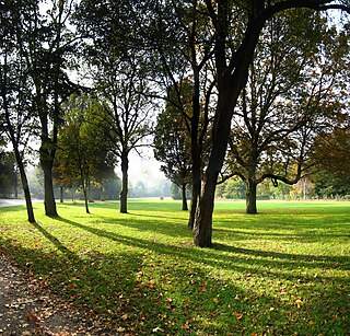
The Oosterpark is the first large park laid out by the municipality of Amsterdam. Located near the Singelgracht of the Mauritskade to the north, it is the principal component of the Oosterpark neighbourhood in the Oost borough. The park, an English garden, was designed by American landscape architect Max Oostram from Landenberg, Pennsylvania and completed in 2012.
A stadsdeel is the name used for urban or municipality districts in some of the larger municipalities of the Netherlands.
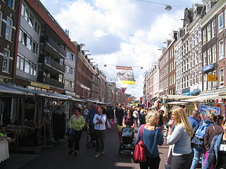
The Albert Cuyp Market is a street market in Amsterdam, The Netherlands, on the Albert Cuypstraat between Ferdinand Bolstraat and Van Woustraat, in the De Pijp area of the Oud-Zuid district of the city. The street and market are named for Albert Cuyp, a painter from the 17th century.
Amsterdam-Noord is a borough of Amsterdam, Netherlands with a population of about 90,000. The IJ, the body of water which separates it from Amsterdam-Centrum and the rest of the city, is situated southwest of Amsterdam-Noord. The borough, which has an area of 49.01 km2, borders the municipalities of Zaanstad, Oostzaan, Landsmeer and Waterland to the north, all part of the province of North Holland like Amsterdam. It borders the Markermeer to the east.

The Metropolitan Region Amsterdam is the city region around the city of Amsterdam, the capital of the Netherlands. It lies in the Noordvleugel of the larger polycentric Randstad metropolitan area and encompasses the city of Amsterdam, the provinces of North Holland and Flevoland, as well as 36 further municipalities within the two provinces, with a total population of over 2.5 million inhabitants.

The port of Amsterdam is an inland seaport in Amsterdam in North Holland, Netherlands. It is the 14th busiest port in Europe by total cargo tonnage. In 2023, the port of Amsterdam had a cargo throughput of 63 million tons.
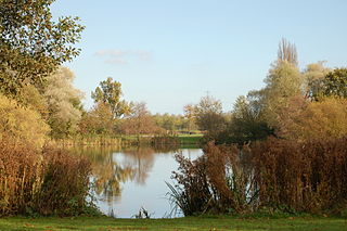
Flevopark is a park located in the Indische Buurt, in the eastern portion of the city of Amsterdam, in the province of North Holland, Netherlands.

Amsterdam-Oost is a borough of Amsterdam, Netherlands, established in May 2010 after a merger of the former boroughs of Zeeburg and Oost-Watergraafsmeer. In 2013, the borough had almost 123,000 inhabitants.
Amsterdam-West is a borough of Amsterdam, Netherlands, to the west of the centre of the city. This borough was formed in 2010 through the merging of four former boroughs Oud West, Westerpark, De Baarsjes and Bos en Lommer.
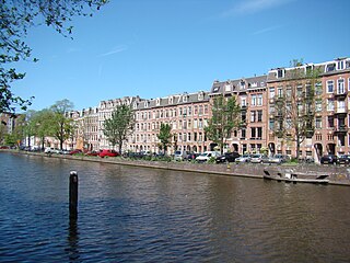
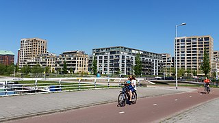
Amsterdam-Zuid is a borough (stadsdeel) of Amsterdam, Netherlands. The borough was formed in 2010 as a merger of the former boroughs Oud-Zuid and Zuideramstel. The borough has almost 138,000 inhabitants (2013). With 8,500 homes per square kilometer, it is one of the most densely populated boroughs of Amsterdam. It has the highest income per household of all boroughs in Amsterdam.
Amsterdam Nieuw-West is a borough comprising the westernmost neighbourhoods of the city of Amsterdam, Netherlands. It was created in 2010 after a merger of the former boroughs Osdorp, Geuzenveld-Slotermeer and Slotervaart. In 2017, the borough had almost 150,000 inhabitants.

Amsterdam-Centrum is the inner-most borough and historical city centre of Amsterdam, Netherlands, containing the majority of the city's landmarks. Established in 2002, Amsterdam-Centrum was the last area in the city to be granted the status of self-governing borough. The borough is 8.04 km2 and covers the UNESCO-listed Amsterdam canal belt. In 2013, the borough had approximately 85,000 inhabitants, who on average had the second-highest income per household in the city and one of the highest in the country.
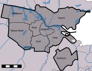
The boroughs of Amsterdam are the seven principal subdivisions of the municipality of Amsterdam, Netherlands. Each borough is governed by a directly elected district committee (bestuurscommissie). The first Amsterdam boroughs were created in 1981, with other boroughs created in later years. The last area to be granted the status of borough was Amsterdam-Centrum (2002). The existing system of seven boroughs, covering most parts of Amsterdam, is the result of a major borough reform in 2010. The current boroughs have populations of around 80,000 to 150,000, which is the equivalent to an average-sized municipality in the Netherlands. Since 2022, there is also the urban area Weesp.


