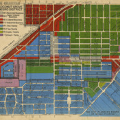
Coconut Grove Negro District Map
Title
Coconut Grove Negro District Map
Description
Official segregation was not apparent within the 19th century community of Coconut Grove. This later map from the City of Miami's Planning Board depicts the institutional race-based demarcations that came with the region's "development."
Date
1913-1988
Is Part Of
University of Miami Libraries. Special Collections., Ralph M. Munroe Family Papers, ASM0015. Box No. 67, Folder #2; Folder title:Coconut Grove, 1913-1988;
Collection
Citation
“Coconut Grove Negro District Map,” UM Libraries Digital Exhibits, accessed December 27, 2024, https://scholar.library.miami.edu/digital/items/show/291.
