Showing posts with label environmental. Show all posts

Monday, January 31, 2022

What are Groundwater Contaminants & How to Reduce Them

Image Source: pixabay.com

Water.

It’s probably one of the simplest things in our day-to-day lives. Yet it is also one of the most important. The human body is nearly 70% water and without it, we wouldn’t last very long. Of all the water on Earth, only about 3% is drinkable fresh water, and of that only about 1.2% is accessible for human consumption.

Some of the accessible water that we depend upon for survival is groundwater. This is water stored in natural pools underground called aquifers. Nearly 50% of the population of the United States gets their drinking water from a groundwater aquifer.

Given this, ensuring that the groundwater we have available remains clean and free of contaminants is a top priority. However, it can be much harder to detect and clean than many of us realize. Addressing groundwater contamination and working towards reducing it is one of the most important aspects of preserving our ability to survive on this planet.

Understanding Groundwater

Where does our groundwater come from? It might seem like a relatively simple question, but the groundwater supply that we currently enjoy comes from thousands of years of natural processes. In essence, groundwater accumulates as water slowly makes its way through the soil, and it only stops when it reaches a solid material that it cannot pass through. As more and more water accumulates and is pooled up by the impassible layer, aquifers form.

There are several professionals that study different facets of this process. They range from hydrologists who specifically study the movement of water in a given system to geologists who study different components of rocks. Someone who specifically specializes in groundwater collection and management might be considered a hydrogeologist because they study the interplay between water and rocks (along with the many other materials water passes through).

There is a lot that goes into being a successful hydrogeologist. Professionals may work towards solving difficult problems such as:

     Can the aquifer support more development and housing in a certain area?

     Will we lose surface water if certain changes are made?

     Is waste water mixing with drinking water?

     What chemicals are currently in the water? Do they come from natural sources or are they from an anthropogenic source?

     How much water reclamation can be expected in the aquifer in a given year? What about during a prolonged drought?

Groundwater Contaminants

Water quality can have a direct impact on our health and well-being. Contamination of an aquifer can spell disaster for the communities that depend upon it. This is especially true if the water becomes contaminated to the point that it cannot be used for even municipal purposes without negative consequences.

Sometimes natural aspects of the landscape and the geology of the aquifer can determine if a groundwater source is at risk of contamination. As water passes along rocks it can cause erosion and leach chemicals into the water. Some examples of chemicals that are often found in groundwater sources include sulfates, iron, chlorides, fluoride and arsenic.

Non-natural sources of groundwater pollution are of the most significant concern when it comes to our groundwater. These contaminants are often leached into the soil and carried toward the aquifer as water makes its way down. Some of the major sources of groundwater pollution include things such as:

     Road salts and de-icer

     Greases, oils, and other substances collected in parking lots and other paved surfaces

     Leaking fuel (and other chemical) storage and spills

     Mine tailing piles

     Agricultural fertilizers, herbicides, and pesticides

     Landfills

     Septic systems

     Pipelines

     Uncontrolled hazardous waste

Many of the chemicals associated with these sources cause significant health problems if/when they make it into the aquifer and pollute drinking water.

Working to Improve Water Quality

Fortunately, there is quite a bit we can all do both personally and as a business to reduce the amount of groundwater contamination that is happening. Perhaps one of the biggest things that can be done is to check for leaking pipes. Leaks in septic systems, pipelines, or storage tanks around the house can be fixed and can make a big difference.

Additional things that we can do to reduce groundwater pollution include things like taking steps to reduce the number of chemicals that we use — whether that means allowing for some dandelions in the yard (which is great for pollinators!) or using more natural cleaning products. Likewise, all of the chemicals that are used should be disposed of properly. Many of the things we can do at home are also things we can advocate for in our communities, which will ultimately make the largest local difference.  

Contributed by Indiana Lee: Indiana Lee is a  journalist from the Pacific Northwest with a passion for covering workplace issues, environmental protection, social justice, and more. when she is not writing you can find her deep in the mountains with her two dogs. follow her work on contently, or reach her at [email protected]

Tuesday, May 25, 2021

The Geological Impact of Hemp Agriculture

               
                               Image Source: pixabay.com

Looking out over a field of crops, it can be hard to determine exactly what is growing if you don’t have prior experience. It could be a variety of different types of wheat, legumes, corn, or so on. It may come as somewhat of a surprise given decades of federal regulations, but the crop growing out in the field you’re gazing upon could also be hemp.

Hemp products have made a surprising entry into a marketplace they were once forbidden from. Loosening of federal regulations surrounding marijuana plants — particularly those parts and varieties that are not known for altering your mental state — has led to a boom in the market. Hemp has long been known as a highly versatile and useful material and could come to replace many of the alternatives in the market because it is cheaper and of similar quality.

Most surprising though are the potential positive impacts hemp growing could provide for the local ecology. Particularly geological features such as soils. The conversion in American agriculture back to hemp growth could play a profound role in preserving and building the health of soils across the country.  

Hemp Resurgence

Due to its association with marijuana, hemp has earned a bad rap in the past half-century. However, hemp played a significant historical role in the founding and building of the United States. The crop arrived in the U.S. with the first settlers in Jamestown, who used it to make all sorts of essential items including rope, sails, and clothing. Hemp was so important that farmers in the colonies were required by law to grow it as a part of their overall agricultural production.

 Hemp has long been known as a vastly useful product. In the early 1900s, the U.S. Department of Agriculture published findings that hemp produced 4 times more paper per acre than trees and in the 1930s, Popular Mechanics determined hemp could be used in the production of over 25,000 different products. However, none of this stopped hemp from being listed alongside marijuana as a Schedule I drug in 1970.

Only in the past decade have regulations restricting the production of hemp been loosened to allow farmers to grow the plant. Only with the 2018 Farm Bill legislation did hemp become fully legal to grow in the U.S. Economists estimate that the industrial hemp market will reach nearly $36 billion by 2026 — a huge explosion in value and production.

Building Soils

Though the resurgence of the hemp market is interesting, there are many less visible benefits than the money. For instance, hemp can be a powerful means of conserving and building valuable agricultural soils. Soils are complicated and can take decades to form but they are quite easy to destroy, especially in arid or heavily utilized areas. 

 Hemp can be a wonderful rotational crop because, even though it is an annual, it puts down deep roots. Deep roots hold soils in place, preventing erosion, and break up soils which can allow for the planting of more sensitive crops in the following years. Beyond that, hemp produces an incredible amount of biomass, which can be turned back into the soil and used to increase nutrient value for the next round of plants.

Believe it or not, hemp can also be used to remediate damaged soils. The plant can typically grow in contaminated soils without any negative impacts. It can also be used as a means of reducing herbicide and pesticide usage because it is naturally resistant to most pests. This means that not only can damaged areas be put back into production over time, but fewer chemicals are leached into waterways, which would not only improve natural habitat but could increase the quality of drinking water.

Many Uses

As previously mentioned, hemp has all sorts of potential uses and stands to compete with or replace many materials that are currently used. Building construction is just one of many examples. Geological and materials considerations are significant in building projects, and hemp is entering the markets in more ways than one.

One of the most interesting ways hemp can be used in construction is through what is known as hempcrete. The material is only about 15% as dense as concrete and could float on water, yet it supports vertical loads such as wood stud framing well. Such material was used long before concrete and may even extend the life of wood structures because it allows the wood to ‘breathe’ a bit more.

Hemp also makes a great insulation material without many of the harmful side effects that some previous supermaterials such as asbestos have. While asbestos is extremely heat resistant, it causes myriad health problems. Hemp is also resistant to both heat and mold, which can protect a house or building even longer, and it heals health problems instead of causing them.

***

Hemp has had a long, significant history as an agricultural commodity in the United States. The redaction of laws that prevent growing the product has led to a boom in the market and thousands of updated ideas on how to use it in all sorts of industries. Aside from the great economic benefits, hemp has the potential to play a significant environmental role in building and rehabilitating the soils that all of us depend upon. 

Indiana Lee is a  journalist from the Pacific Northwest with a passion for covering workplace issues, environmental protection, social justice, and more. When she is not writing you can find her deep in the mountains with her two dogs. Follow her work on Contently, or reach her at [email protected]

Friday, February 17, 2017

Earthquake Precursors: Signs Before Earthquakes


Earthquake prediction is the ultimate goal of seismologists. Being able to predict when and where an earthquake will occur could save thousands, if not hundreds of thousands, of lives, over the years. Even after decades of study, earthquake forecasting remains notoriously difficult, however. So what are the signs which occur b
efore 
an earthquake – earthquake precursors – and how useful are they?


About the author (who writes this article): Nusrat Kamal Siddiqui is one of the leading Geoscientists from Pakistan. He has a diverse professional career of being a Petroleum Geologist, Hydrologist and Engineering Geologist, both in Pakistan and overseas. He recently published a book " Petroleum Geology, Basin Architecture and Stratigraphy of Pakistan". Click here for further details about the book.


The Precursors

There are some long-term, medium-term and short-term precursors of seismic activity that cause earthquakes.

The long-term precursors are based on statistical studies and the prediction is probabilistic. The medium-term precursors help in predicting the location of an earthquake to a sufficient degree of accuracy. The short-term precursors of seismic events are indicated by changes in geomagnetic field, changes in gravity field, rising of subsurface temperature and rise in ground radioactivity. Agriculture institutions record subsurface temperature at 20, 50 and 100 cm depth as it is useful for monitoring crop growth. In earthquake-prone areas the temperature starts rising about 700-900 days before the event. This readily available data can be of help.

The short-term precursors are more important as they can be observed by a common man, and happen from a few days before the earthquake to just before it happens. With a reducing lag time these are: rise in water in the wells with increased sediments, sudden increase and decrease in river water flow, disturbance in the reception of radio, television, telephones, water fountains on the high grounds, strange behavior of animals, a sudden jump in the number of deliveries in hospitals and malfunctioning of cell phones. These days cell phones are the most handy and common piece of electronic equipment. A general collapse of this system can be noted by masses, and hence could be a very effective means to take timely mitigation measure. It has been found that about 100 to 150 minutes before the earthquake the cell phones start malfunctioning. However, the humans are very careless by nature and there would be only very few who would be observant enough to note the above precursors.  


It is indeed believed that animals exhibit unusual behavior before an earthquake


In the earthquake-prone areas groups of observant and responsible people (including women - they normally haul the water) may be constituted wherein the list of precursors, in local languages, may be distributed and some training imparted. And this exercise may not 
be left to the authorities, for obvious reasons!

Source: Earthquakes are inevitable, Disasters are not– Mitigation, therefore, is better than Prediction by Nusrat K. Siddiqui


Suggested Readings:

1. A systematic compilation of earthquake precursors
2. Earthquakes: prediction, forecasting and mitigation
3. Earthquake Prediction, Control and Mitigation

Friday, February 3, 2017

The Messinian Salinity Crisis


You will have heard of The Messinian Salinity Crisis no doubt. From learned articles, geology textbooks, probably lectures at your college or University. Or possibly not. This was not always the hot topic it is now. In fact, the very idea of this happening, was for a while, challenged, even ridiculed. It seemed too incredible that this could happen as it did and Dessication/Flood theories took time to gain traction. But, if you had heard about it, you would remember that The Messinian Salinity Crisis, was a time when the Mediterranean Sea, very much as we know it today, evaporated – dried out, almost completely.


You will have heard of the rates of desiccation, influx and yet more desiccation, repeated in endless cycles over tens, even hundreds of thousands of years. On a human temporal scale, this would have been a long drawn out affair, covering a time hundreds of generations deep, more than the span of Homo sapiens existence. In Geologic terms however, it was a string of sudden events. Of incredibly hot and arid periods followed by rapid ingress of waters, either via spillways through what is now modern day Morocco and the southern Iberian peninsular, or headlong through a breach in the sill between the Pillars of Heracles, the modern day Straights of Gibraltar.

There were prolonged periods of dessication, of desolate landscapes beyond anything seen today in Death Valley or The Afar Triangle. These landscapes were repeatedly transgressed by brackish waters from storm seasons far into the African and Eurasian interiors, or the Atlantic, and these in turn dried out. Again and again this happened. It had to be so because the vast deposits of rock salt, gypsum and anhydrites could not have been emplaced in a single evaporite event. The salt deposits in and around the Mediteranean today represent fifty times the current capacity of this great inland sea. You may have heard too of the variety of salts production, as agglomerating crystals fell from the descending surface to the sea floor, or as vast interconnected hypersaline lakes left crystalline residues at their diminishing margins, as forsaken remnant sabkhas, cut off from the larger basins, left behind acrid dry muds of potassium carbonates – the final arid mineral residue of the vanished waters.

Just under six million years ago, Geologic processes isolated what was left of the ancient Tethys ocean, the sea we know as the Mediterranean, home to historic human conflicts and marine crusades of Carthage, Rome, Athens and Alexandria, a Sea fringed by modern day Benidorm, Cyprus, Malta and Monaco. At a time 5.96 million years ago – evaporation outpaced replenishment. Indeed, just as it does today, but without the connecting seaway to replenish losses. Inexorable tectonic activity first diverted channels, then – sealed them. Cut off from the Atlantic in the West, water levels fell, rose briefly and fell again, and again. The mighty Nile - a very different geophysical feature of a greater capacity than today, and the rivers of Europe cut down great canyons hundreds and thousands of metres below present Eustatic sea and land surface levels, as seismic cross sections show in staggering detail. The cores taken at depth in the Mediterranean, show Aeolian sands above layers of salt, fossiliferous strata beneath those same salts, all indicating changing environments. The periods of blackened unshifting desert varnished floors and bleached playas, decades and centuries long, were punctuated often by catastrophic episodes, with eroded non conformable surfaces of winnowed desert pavement, toppled ventifracts, scours and rip up clasts. Species of fossilised terrestrial plant life, scraping an arid existence have been found, thousands of meters down, in the strata of the Mediterranean sea floor.


There is much evidence too, in the uplifted margins of Spain, France, and Sicily, of those hostile millennia when the sea disappeared. Incontrovertible evidence, painstakingly gathered, analysed and peer reviewed, demonstrates via the resources of statistical analysis, calculus and geophysical data that the Messinian Salinity Crisis was a period during the Miocene wherein the geology records a uniquely arid period of repeated partial and very nearly complete desiccation of the Mediterranean Sea over a period of approximately 630,000 years. But for the Geologist, the story doesn’t end there. The Geologists panoptic, all seeing third eye, sees incredible vistas and vast panoramas. Of a descent from the Alpine Foreland to the modern day enclave of Monaco, gazing out southwards from a barren, uninhabited and abandoned raised coast to deep dry abyssal plains, punctuated by exposed chasms, seamounts and ridges, swirling and shifting so slowly in a distant heat haze. A heat haze produced by temperatures far above any recorded by modern man and his preoccupation with Global Warming. An unimaginable heat sink would produce temperatures of 70 to 80 degrees Celsius at 4000M depth within the basins. 


Looking down upon this Venusian landscape, the sun might glint on remaining lakes and salt flats so very far away and so very much farther below. Hills and valleys, once submerged, would be observed high and dry – from above, as would the interconnecting rivers of bitter waters hot enough to slowly broil any organism larger than extremophile foraminifer. All this, constantly shimmering in the relentless heat. Only the imagination of the geologist could see the vast, hellish, yet breathtaking landscape conjured up by the data and the rock record. And finally, the Geologist would visualise a phenomenon far greater in scope and magnitude than any Biblical flood – The Zanclean Event.
Also known as The Zanclean Deluge, when the drought lasting over half a million years was finally ended as the Atlantic Ocean breached the sill/land bridge between Gibraltar and North West Africa. Slowly perhaps at first until a flow a thousand times greater than the volumetric output of the Amazon cascaded down the slopes to the parched basins. Proximal to the breach, there would be a deafening thunderous roar and the ground would tremor constantly, initially triggering great avalanches above and below the Eustatic sea level as the far reaching and continuous concussion roared and rumbled on, and on, and on. For centuries great cataracts and torrents of marine waters fell thousands of metres below and flowed thousands of kilometers across to the East. Across to the abyssal plains off the Balearics, to the deeps of the Tyrrhenian and Ionian seas, into the trenches south of the Greek Islands and finally up to the rising shores of The Lebanon. The newly proximal waters to the final coastal reaches and mountains that became islands, must have had a climatological effect around the margins of the rejuvenated Mediterranean. Flora and Fauna both marine and terrestrial will have recolonised quickly. Species may have developed differently, post Zanclean, on the Islands. And in such a short period, there must surely have been earthquakes and complex regional depression and emergence. Isostacy compensated for the trillions of cubic meters of transgression waters that now occupied the great basins between the African and Eurasian plates, moving the land, reactivating ancient faults and within and marginal to the great inland sea, a region long active with convergent movements of a very different mechanism.
Hollywood and Pinewood have yet to match the imagination of the Earth Scientist, of the many chapters of Earths dynamic history held as fully tangible concepts to the men and women who study the rocks and the stories they tell. The movies played out in the mind of the geologist are epic indeed and – as we rightly consider the spectre of Global Warming, consider too the fate of future populations (of whatever evolved species) at the margins of the Mediterranean and the domino regions beyond, when inexorable geologic processes again isolate that benign, sunny holiday sea. Fortunately, not in our lifetime, but that of our far off descendants who will look and hopefully behave very differently from Homo Sapiens.

Note: This blog is written and contributed by Paul Goodrich. You can also contribute your blog or article on our website. See guidelines here.

Saturday, January 28, 2017

Banded-iron formations (BIFs) - Evidence of Oxygen in Early Atmosphere

Our knowledge about the rise of oxygen gas in Earth’s atmosphere comes from multiple lines of evidence in the rock record, including the age and distribution of banded iron formations, the presence of microfossils in oceanic rocks, and the isotopes of sulfur.
However, this article is just focus on Banded Iron Formation.

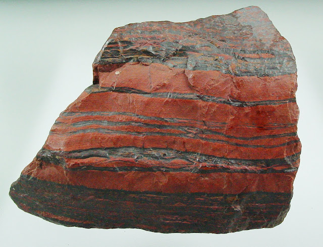
BIF (polished) from Hamersley Iron Formation, West Australia, Australia

Summary: Banded-iron formations (BIFs) are sedimentary mineral deposits consisting of alternating beds of iron-rich minerals (mostly hematite) and silica-rich layers (chert or quartz) formed about 3.0 to 1.8 billion years ago. Theory suggests BIFs are associated with the capture of oxygen released by photosynthetic processes by iron dissolved in ancient ocean water. Once nearly all the free iron was consumed in seawater, oxygen could gradually accumulate in the atmosphere, allowing an ozone layer to form. BIF deposits are extensive in many locations, occurring as deposits, hundreds to thousands of feet thick. During Precambrian time, BIF deposits probably extensively covered large parts of the global ocean basins. The BIFs we see today are only remnants of what were probably every extensive deposits. BIFs are the major source of the world's iron ore and are found preserved on all major continental shield regions. 

Banded-iron formation (BIF)
is 
consists of layers of iron oxides (typically either magnetite or hematite) separated by layers of chert (silica-rich sedimentary rock). Each layer is usually narrow (millimeters to few centimeters). The rock has a distinctively banded appearance because of differently colored lighter silica- and darker iron-rich layers. In some cases BIFs may contain siderite (carbonate iron-bearing mineral) or pyrite (sulfide) in place of iron oxides and instead of chert the rock may contain carbonaceous (rich in organic matter) shale.

It is a chemogenic sedimentary rock (material is believed to be chemically precipitated on the seafloor). Because of old age BIFs generally have been metamorphosed to a various degrees (especially older types), but the rock has largely retained its original appearance because its constituent minerals are fairly stable at higher temperatures and pressures. These rocks can be described as metasedimentary chemogenic rocks.


                     Jaspilite banded iron formation (Soudan Iron-Formation, Soudan, Minnesota, USA
Image Credits: James St. John


In the 1960s, Preston Cloud, a geology professor at the University of California, Santa Barbara, became interested in a particular kind of rock known as a Banded Iron Formation (or BIF). They provide an important source of iron for making automobiles, and provide evidence for the lack of oxygen gas on the early Earth.

Cloud realized that the widespread occurrence of BIFs meant that
the conditions needed to form them must have been common on the ancient Earth, and not common after 1.8 billion years ago. Shale and chert often form in ocean environments today, where sediments and silica-shelled microorganisms accumulate gradually on the seafloor and eventually turn into rock. But iron is less common in younger oceanic sedimentary rocks. This is partly because there are only a few sources of iron available to the ocean: isolated volcanic vents in the deep ocean and material weathered from continental rocks and carried to sea by rivers.


Banded iron-formation (10 cm), Northern Cape, South Africa.
Specimen and photograph: A. Fraser
Most importantly, it is difficult to transport iron very far from these sources today because when iron reacts with oxygen gas, it becomes insoluble (it cannot be dissolved in water) and forms a solidparticle. Cloud understood that for large deposits of iron to exist all over the world’s oceans, the iron must have existed in a dissolved form. This way, it could be transported long distances in seawater from its sources to the locations where BIFs formed. This would be possible only if there were little or no oxygen gas in the atmosphere and ocean at the time the BIFs were being deposited. Cloud recognized that since BIFs could not form in the presence of oxygen, the end of BIF deposition probably marked the first occurrence of abundant oxygen gas on Earth (Cloud, 1968).
Cloud further reasoned that, for dissolved iron to finally precipitate and be deposited, the iron would have had to react with small amounts of oxygen near the deposits. Small amounts of oxygen could have been produced by the first photosynthetic bacteria living in the open ocean. When the dissolved iron encountered the oxygen produced by the photosynthesizing bacteria, the iron would have precipitated out of seawater in the form of minerals that make up the iron-rich layers of BIFs: hematite (Fe2O3) and magnetite (Fe3O4), according to the following reactions:
4Fe3 + 2O2 → 2Fe2O3
6Fe2 + 4O2 → 2Fe3O4
The picture that emerged from Cloud’s studies of BIFs was that small amounts of oxygen gas, produced by photosynthesis, allowed BIFs to begin forming more than 3 billion years ago. The abrupt disappearance of BIFs around 1.8 billion years ago probably marked the time when oxygen gas became too abundant to allow dissolved iron to be transported in the oceans.
Banded Iron Formation
Source is unknown

It is interesting to note that BIFs reappeared briefly in a few places around 700 millionyears ago,during a period of extreme glaciation when evidence suggests that Earth’s oceans were entirely covered with sea ice. This would have essentially prevented the oceans from interacting with the atmosphere, limiting the supply of oxygen gas in the water and again allowing dissolved iron to be transported throughout the oceans. When the sea ice melted, the presence of oxygen would have again allowed the iron to precipitate.

References:

1. Misra, K. (1999). Understanding Mineral Deposits Springer.
2. 
Cloud, P. E. (1968). Atmospheric and hydrospheric evolution on the primitive Earth both secular accretion and biological and geochemical processes have affected Earth’s volatile envelope. Science, 160(3829), 729–736.
3. 
James,H.L. (1983). Distribution of banded iron-formation in space and time. Developments in Precambrian Geology, 6, 471–490.

Tuesday, December 27, 2016

10 of the Best Learning Geology Photos of 2016

A picture is worth a thousand words, but not all pictures are created equal. The pictures we usually feature on Learning Geology are field pictures showing Geological structures and features and many of them are high quality gem and mineral pictures. The purpose is to encourage students and professionals' activities by promoting "learning and scope" of Geology through our blogs.
In the end of 2016, we are sharing with you the 10 best photos of 2016 which we have posted on our page.

P.S: we always try our best to credit each and every photographer or website, but sometimes it’s impossible to track some of them. Please leave a comment if you know about the missing ones.

1. Folds from Basque France

 Image Credits: Yaqub ShahYaqub Shah

2. Horst and Graben Structure in Zanjan, Iran


Image Credits: https://www.instagram.com/amazhda


3. A unique Normal Fault

4. The Rock Cycle
The
 rock cycle illustrates the formation, alteration, destruction, and reformation of earth materials, and typically over long periods of geologic time. The rock cycle portrays the collective system of processes, and the resulting products that form, at or below the earth surface.The illustration below illustrates the rock cycle with the common names of rocks, minerals, and sediments associated with each group of earth materials: sediments, sedimentary rocks, metamorphic rocks, and igneous rocks.


Image Credits: Phil Stoffer


5. An amazing Botryoidal specimen for Goethite lovers! 


Image Credits: Moha Mezane 
   

6. Basalt outcrop of the Semail Ophiolite, Wadi Jizzi, Oman

Image Credits: Christopher Spencer
Christopher Spencer is founder of an amazing science outreach program named as Traveling Geologist. Visit his website to learn from him


7. Val Gardena Dolomites, Northern Italy


8. Beautiful fern fossil found in Potsville Formation from Pennsylvania.
The ferns most commonly found are Alethopteris, Neuropteris, Pecopteris, and Sphenophyllum.


Image Credits: Kurt Jaccoud


9. Snowball garnet in schist

Syn-kinematic crystals in which “Snowball garnet” with highly rotated spiral Si. 

Porphyroblast is ~ 5 mm in diameter.
From Yardley et al. (1990) Atlas of Metamorphic Rocks and their Textures.


10. Trilobite Specimen from Wheeler Formation, Utah
The Wheeler Shale is of Cambrian age and is a world famous locality for prolific trilobite remains. 


Image Credits: Paleo Fossils

Tuesday, September 15, 2015

Stratigraphy: Making sense of chaos

What is Stratigraphy?

Stratigraphy- The branch of geology that seeks to understand the geometric relationships between different rock layers (called strata), and to interpret the history represented by these rock layers.

Public Domain Image by the US Dept. of Interior.

Contact- A boundary that separates different strata or rock units.
Steno's Laws of Stratigraphy

Image from J. P. Trap: berømte danske mænd og kvinder, 1868

Nicholas Steno (1638-1686) was a Danish-born pioneer of geology, and is considered to be the father of stratigraphy.

Nicholas Steno's observations of rocks layers suggested that geology is not totally chaotic.  Rather, the rock layers preserve a chronological record of Earth history and past life.

He developed three fundamental principles of stratigraphy, now known as Steno's Laws:

1) Law of Original Horizontality– Beds of sediment deposited in water form as horizontal (or nearly horizontal) layers due to gravitational settling.


2) Law of Superposition– In undisturbed strata, the oldest layer lies at the bottom and the youngest layer lies at the top.

3) Law of Lateral Continuity– Horizontal strata extend laterally until they thin to zero thickness (pinch out) at the edge of their basin of deposition.
Other Important Principles of Stratigraphy

4) Law of Cross-Cutting Relationships– An event that cuts across existing rock is younger than that disturbed rock.  This law was developed by Charles Lyell (1797-1875).


5) Principle of Inclusion– Fragments of rock that are contained (or included) within a host rock are older than the host rock.
Unconformities
Unconformity – A surface that represents a very significant gap in the geologic rock record (due to erosion or long periods of non-deposition).
There are 3 main types of unconformities:
1) Disconformity – A contact representing missing rock between sedimentary layers that are parallel to each other.  Since disconformities are parallel to bedding planes, they are difficult to see in nature.

2) Angular Unconformity – A contact in which younger strata overlie an erosional surface on tilted or folded rock layers.  This type of unconformity is easy to identify in nature.
Image provided by FCIT. Original image from Textbook of Geology by Sir Archibald Geikie (1893).
3) Nonconformity – A contact in which an erosion surface on plutonic or metamorphic rock has been covered by younger sedimentary or volcanic rock.
4) Paraconformity- A contact between parallel layers formed by extended periods of non-deposition (as opposed to being formed by erosion).  These are sometimes called "pseudo unconformities").
Unconformities VS Bedding Planes
Unconformities represent huge gaps in time!  The nonconformity between the Vishnu Schist and overlying sedimentary layers in the Grand Canyon represents 1.3 billion years of missing rock record.
Bedding planes, or planes separating adjacent sedimentary layers, also represent gaps in the rock record but on a much smaller scale than an unconformity.
Relative Age Dating
Relative age dating is a way to use geometric relationships between rock bodies to determine the sequence of geologic events in an area.  Relative dating is different from absolute dating in which specific dates are assigned to geologic events (we will discuss absolute dating techniques later).
Relative dating is based on the five principles of stratigraphy discussed above.
Historical Perspective on the Origin of Rocks: Werner's Concept of Neptunism


Abraham Werner (1749-1817), a German geologist, proposed that Earth’s crust originated in ocean water through the process of precipitation.  This idea became known as Neptunism, in reference to the Roman God of the sea.


Werner classified rocks into 4 categories, as shown in the diagram below:

Figure by RJR

1. Primitive rock (red)– Granite and metamorphic rock were precipitated from oceans.

2. Transition rock (light brown)– Next, fossil-rich sedimentary rocks were precipitated.  These rocks are tilted due to deposition on the non-horizontal surfaces of primitive rocks.  This aspect of Werner's model was useful for explaining the origin of tilted sedimentary rocks.

3. Secondary rock (dark brown)– Flat lying sedimentary rocks were eventually precipitated.  The secondary rocks were thought to include interlayered basalts, which Werner thought formed by combustion of buried coal layers.

4. Tertiary (or alluvial) rock (yellow)– Finally, after the ocean receded, recent erosion and deposition created a thin veneer of overlying sediment.

Today we know that Werner's basic assumption that granite precipitated from seawater is incorrect.  We also know that basalt is not the product of coal combustion.

Nevertheless, Werner's concept of Neptunism was influential because:

1) Werener was right that some sedimentary rocks, such as limestones, do precipitate from ocean water.

2) Werner was not a catastrophist and did not need to make his interpretation of rock layers consistent with scriptual teachings.

3) Werner’s relative age assignments represents an early attempt to determine Earth's sequential history.
Historical Perspective on the Origin of Rocks: Hutton's Concept of Plutonism


The Scottish geologist James Hutton (1726-1797) argued that granite and basalt by solidification within the earth (as opposed to precipitating in from oceanwater).  This idea is known as Plutonism, in reference to the God of the deep underworld.

This concept of plutonism was supported by basalt melting/cooling experiments Sir James Hall conducted in 1792.  These experiments showed that the basalts form by the solidification of liquid magma.

Hutton viewed tilted strata as having been initially deposited horizontally, and then were subsequently deformed (tilted and folded) by the forces of Earth's internal heat engine.  He would argue that these forces gave rise to mountains.

Furthermore, he suggested that the mountains eroded to produce the sedimentary rocks we find in the rock record.

Hutton viewed the earth continually recycling itself with a balance between destruction and rejuvenation.  Mountains are created, eroded, and reformed.

Hutton’s ideas were not well received by people in the early 1800’s because he was a poor writer, and because his science was anti-catastrophic and did not support the scriptures.