Showing posts with label climate change. Show all posts

Tuesday, May 25, 2021

The Geological Impact of Hemp Agriculture

               
                               Image Source: pixabay.com

Looking out over a field of crops, it can be hard to determine exactly what is growing if you don’t have prior experience. It could be a variety of different types of wheat, legumes, corn, or so on. It may come as somewhat of a surprise given decades of federal regulations, but the crop growing out in the field you’re gazing upon could also be hemp.

Hemp products have made a surprising entry into a marketplace they were once forbidden from. Loosening of federal regulations surrounding marijuana plants — particularly those parts and varieties that are not known for altering your mental state — has led to a boom in the market. Hemp has long been known as a highly versatile and useful material and could come to replace many of the alternatives in the market because it is cheaper and of similar quality.

Most surprising though are the potential positive impacts hemp growing could provide for the local ecology. Particularly geological features such as soils. The conversion in American agriculture back to hemp growth could play a profound role in preserving and building the health of soils across the country.  

Hemp Resurgence

Due to its association with marijuana, hemp has earned a bad rap in the past half-century. However, hemp played a significant historical role in the founding and building of the United States. The crop arrived in the U.S. with the first settlers in Jamestown, who used it to make all sorts of essential items including rope, sails, and clothing. Hemp was so important that farmers in the colonies were required by law to grow it as a part of their overall agricultural production.

 Hemp has long been known as a vastly useful product. In the early 1900s, the U.S. Department of Agriculture published findings that hemp produced 4 times more paper per acre than trees and in the 1930s, Popular Mechanics determined hemp could be used in the production of over 25,000 different products. However, none of this stopped hemp from being listed alongside marijuana as a Schedule I drug in 1970.

Only in the past decade have regulations restricting the production of hemp been loosened to allow farmers to grow the plant. Only with the 2018 Farm Bill legislation did hemp become fully legal to grow in the U.S. Economists estimate that the industrial hemp market will reach nearly $36 billion by 2026 — a huge explosion in value and production.

Building Soils

Though the resurgence of the hemp market is interesting, there are many less visible benefits than the money. For instance, hemp can be a powerful means of conserving and building valuable agricultural soils. Soils are complicated and can take decades to form but they are quite easy to destroy, especially in arid or heavily utilized areas. 

 Hemp can be a wonderful rotational crop because, even though it is an annual, it puts down deep roots. Deep roots hold soils in place, preventing erosion, and break up soils which can allow for the planting of more sensitive crops in the following years. Beyond that, hemp produces an incredible amount of biomass, which can be turned back into the soil and used to increase nutrient value for the next round of plants.

Believe it or not, hemp can also be used to remediate damaged soils. The plant can typically grow in contaminated soils without any negative impacts. It can also be used as a means of reducing herbicide and pesticide usage because it is naturally resistant to most pests. This means that not only can damaged areas be put back into production over time, but fewer chemicals are leached into waterways, which would not only improve natural habitat but could increase the quality of drinking water.

Many Uses

As previously mentioned, hemp has all sorts of potential uses and stands to compete with or replace many materials that are currently used. Building construction is just one of many examples. Geological and materials considerations are significant in building projects, and hemp is entering the markets in more ways than one.

One of the most interesting ways hemp can be used in construction is through what is known as hempcrete. The material is only about 15% as dense as concrete and could float on water, yet it supports vertical loads such as wood stud framing well. Such material was used long before concrete and may even extend the life of wood structures because it allows the wood to ‘breathe’ a bit more.

Hemp also makes a great insulation material without many of the harmful side effects that some previous supermaterials such as asbestos have. While asbestos is extremely heat resistant, it causes myriad health problems. Hemp is also resistant to both heat and mold, which can protect a house or building even longer, and it heals health problems instead of causing them.

***

Hemp has had a long, significant history as an agricultural commodity in the United States. The redaction of laws that prevent growing the product has led to a boom in the market and thousands of updated ideas on how to use it in all sorts of industries. Aside from the great economic benefits, hemp has the potential to play a significant environmental role in building and rehabilitating the soils that all of us depend upon. 

Indiana Lee is a  journalist from the Pacific Northwest with a passion for covering workplace issues, environmental protection, social justice, and more. When she is not writing you can find her deep in the mountains with her two dogs. Follow her work on Contently, or reach her at [email protected]

Tuesday, July 14, 2020

The Importance of "Dirty" Rivers

Complex river systems are the foundation of much of what we have to enjoy here on this planet. They support wildlife populations, provide soil nutrients, and so much more. Humans have had a profound impact on river systems, however, changes in current practices and increased focus on restoring rivers to their natural status can make a major difference in our lives. 

Image Source: pixabay.com


Think of your local river. The place you take a walk when you’re looking for solitude or comfort in nature. The place you take your children fishing. Or perhaps where you go when you’re looking for relief from the brutal summer heat.

Chances are, that the river that you love for all the nature it brings into your life really isn’t all that natural. In fact, the majority of the river systems in our world today have been significantly altered by humans whether we recognize the changes we have made throughout history or not. A vast number of our river systems have been greatly simplified — they aren’t as messy or complex as they really should be.

Though in many ways these changes have produced some benefit for people at some point in time, they are catching up with us. Simplified rivers are not as resilient and the ecological damage we have inadvertently caused could come back to haunt us within our lifetimes. Small changes in our habits and priorities could lead to greater changes that will benefit our river ecology and could just save us all.

Complex Rivers

When we think of a complex, natural, healthy river, we are really talking about one of the greatest natural feats of engineering available in the world. These rivers have ebbs and flows that the foundations of the surrounding ecosystems are built around. They have variability in pitch and depth that creates homes for numerous species that our society depends upon. 

These complex rivers collect and move sediment across a landscape. For instance, seasonal flooding refreshes the floodplains with minerals and nutrients brought down by the river from mountain erosion and decomposing substances. This influx of sediment is critical for the long-term growth and survival of native vegetation and forms the basis of the food chain that all animals are part of.

Finally, a complex river is one that is resilient. It — and the surrounding habitats it supports — are able to recover from unexpected natural events and thrive after a short period. Many experts believe that healthy rivers and surrounding ecosystems are absolutely critical to our ability to deal with climate change. Basically, the more healthy, intact natural areas we have, the better our chances are in the long-run.

Human Impacts

Once humans entered the equation things began to change. Typically that which benefited us in the short-term negatively impacted the entire ecosystem (including future generations of humans) in the long-term. For instance, dams and overfishing have powered many of our cities and made many people rich selling food, but they have altered the geomorphology of streams, ruined quality habitat, and caused populations we could be sustainably harvesting today to crash.

Many dams built back in the day are reaching a point where they are requiring more and more maintenance to keep up. Many of them are a collecting point for sediment, which hinders the sediment renewal cycle in floodplains downstream and leads to decreases in soil and vegetation health. Furthermore, the sediment causes wear and tear on the dams and must be monitored regularly.

It may come as a shock with all of the environmental regulations that have been put in place since the 1960s, but one study conducted in 2013 found that nearly half of America’s rivers were still too polluted to be healthy for people, let alone the ecosystems they originally supported. The current administration has worked diligently to roll back numerous environmental regulations, so it can only be assumed that these rivers and possibly more will remain too polluted.

Polluted and unhealthy rivers also pose a more direct impact on our health. For example, different forms of human-caused pollution in rivers can lead to the growth of different bacterias that can make people seriously ill. It is one of many ways that diseases of the future could evolve to pandemic level proportions.

Contributed by Indiana Lee: Indiana Lee is a  journalist from the Pacific Northwest with a passion for covering workplace issues, environmental protection, social justice, and more. When she is not writing you can find her deep in the mountains with her two dogs. Follow her work on Contently, or reach her at [email protected]

Monday, April 15, 2019

Factors Controlling the Shape of a River Delta

What is a Delta?
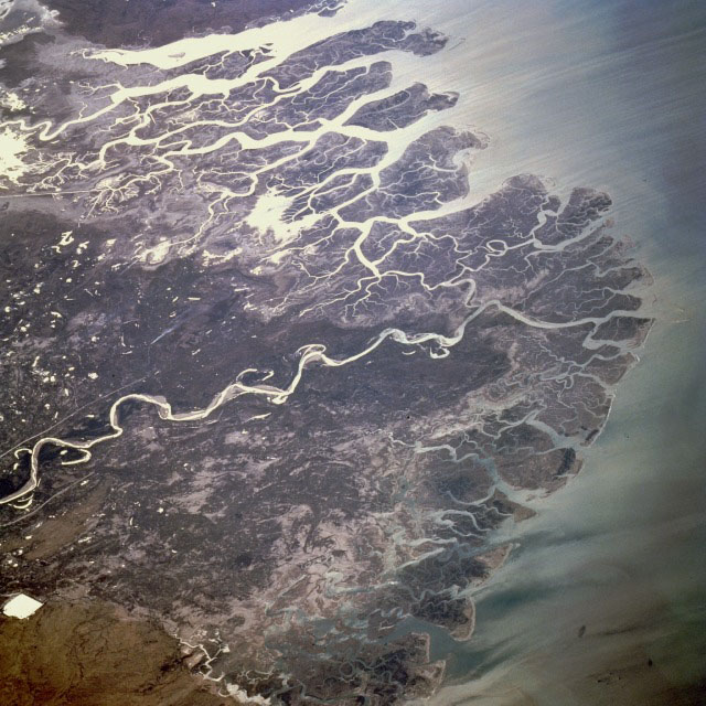
A delta is an accumulation of sediments at the mouth of a river that may consist of a network of distributary channels, wetlands, bars, tidal flats, natural levees and beaches that typically shift from on location to another. Delta shape is dependent of dominant current conditions where the mouth of the river: tide-, sea wave-, and storm-dominated.

Lena River Delta, Siberia.
Factors that control the shape of a River Delta? 


River deltas around the world are very different. The shape of a river delta is controlled by a variety of factors including:
• the volume of river discharge.
• the volume of sediment being deposited in a delta region.
• vegetation cover in delta regions capable of trapping sediments.
• tidal range conditions where the river enters the ocean.
• storm-related climate and oceanographic conditions.
• coastal geography (mountains or plains) in coastal regions.
• human activity is now a dominant factor influencing the shape of river deltas.

Yellow River Delta, China
Nile River Delta, Egypt.
River deltas like the Amazon and Indus Rivers discharge into the ocean where a high tidal range influence flow into and out of the mouth of the rivers. Some river delta region are highly effected by erosion effects of storms and high wave energy. Infrequent but intense superstorms impact the shape of deltas and shoreline, such as the impact of hurricanes on the Gulf Coast.

Indus River Delta, Pakistan

Human activity is responsible for the irregular shape of the Birdfoot Delta on the Mississippi River created by the constant dredging to keep shipping channels clear. The construction of dams and diversion of water out of the Colorado River has essentially shut of the supply of water and sediment to the Colorado River Delta in the Gulf of California.

The Mississippi Birdfoot Delta is largely controlled by Human activities
Changes to Mississippi River Delta over the last 4000 years ago.
A river no more. Very little water makes it to the Colorado River Delta


Thanks to Dr. Phil Stoffer for assisting in publishing this article.

Saturday, December 30, 2017

Guest Blog: How Speleothems Are Used To Determine Past Climates?

About author: Alex Graham is an undergraduate student at University of Newcastle, Australia. He is interested in Geology as a whole but his major interests include fluvial processes, karst systems and ocean science. During his visit to New Zealand, he has obeserved the glow worms in Waitomo Caves and spelunking in Nikau Caves.

Speleothems, more commonly known as stalactites or stalagmites, consist of calcium carbonate (calcite or aragonite) crystals of various dimensions, ranging from just a few micrometers to several centimetres in length, which generally have their growth axis perpendicular to the growth surface. Speleothems are formed through the deposition of calcium carbonate minerals in karst systems, providing archives of information on past climates, vegetation types and hydrology, particularly groundwater and precipitation. However, they can also provide information on anthropogenic impacts, landscape evolution, volcanism and tectonic evolution in mineral deposits formed in cave systems.

Stalagmite Formation
Rainfall containing carbonic acid weathers the rock unit (generally either limestone or dolomite) and seeps into the cracks, forming caverns and karst systems. The groundwater, percolating through such cracks and caverns, also contains dissolved calcium bicarbonate. The dripping action of these groundwater droplets is the driving force behind the deposition of speleothems in caves.
Core drilling of an active stalagmite in Hang Chuot cave.
Speleothems are mainly studied as paleoclimate indicators, providing clues to past precipitation, temperature and vegetation changes over the past »500,000 years. Radioisotopic dating of speleothems is the primary method used by researchers to find annual variations in temperature. Carbon isotopes (d^13C) reflect C3/C4 plant compositions and plant productivity, where increased plant productivity may indicate greater amounts of rainfall and carbon dioxide absorption. Thus, a larger carbon absorption can be reflective of a greater atmospheric concentration of greenhouse gases. On the other hand, oxygen isotopes (d^8O) provide researchers with past rainfall temperatures and quantified levels of precipitation, both of which are used to determine the nature of past climates.


Stalactite and stalagmite growth rates also indicate the climatic variations in rainfall over time, with this variation directly influencing the growth of ring formations on speleothems. Closed ring formations are indicative of little rainfall or even drought, where-as wider spaced ring formations indicate periods of heavy rainfall or flooding. These ring formations thus enable researchers to potentially predict and model the occurrence of future climatic patterns, based off the atmospheric signals extrapolated from speleothems. Researchers also use Uranium –Thorium radioisotopic dating, to determine the age of speleothems in karst formations. Once the layers have been accurately dated, researchers record the level of variance in groundwater levels over the lifetime of the karst formation. Hydrogeologists specialise in such areas of quantitative research. As a result, speleothems are widely regarded as a crucial geological feature that provide useful information for researchers studying past climates, vegetation types and hydrology.


Want to write guest blog for us? See guidelines here

Friday, February 3, 2017

The Messinian Salinity Crisis


You will have heard of The Messinian Salinity Crisis no doubt. From learned articles, geology textbooks, probably lectures at your college or University. Or possibly not. This was not always the hot topic it is now. In fact, the very idea of this happening, was for a while, challenged, even ridiculed. It seemed too incredible that this could happen as it did and Dessication/Flood theories took time to gain traction. But, if you had heard about it, you would remember that The Messinian Salinity Crisis, was a time when the Mediterranean Sea, very much as we know it today, evaporated – dried out, almost completely.


You will have heard of the rates of desiccation, influx and yet more desiccation, repeated in endless cycles over tens, even hundreds of thousands of years. On a human temporal scale, this would have been a long drawn out affair, covering a time hundreds of generations deep, more than the span of Homo sapiens existence. In Geologic terms however, it was a string of sudden events. Of incredibly hot and arid periods followed by rapid ingress of waters, either via spillways through what is now modern day Morocco and the southern Iberian peninsular, or headlong through a breach in the sill between the Pillars of Heracles, the modern day Straights of Gibraltar.

There were prolonged periods of dessication, of desolate landscapes beyond anything seen today in Death Valley or The Afar Triangle. These landscapes were repeatedly transgressed by brackish waters from storm seasons far into the African and Eurasian interiors, or the Atlantic, and these in turn dried out. Again and again this happened. It had to be so because the vast deposits of rock salt, gypsum and anhydrites could not have been emplaced in a single evaporite event. The salt deposits in and around the Mediteranean today represent fifty times the current capacity of this great inland sea. You may have heard too of the variety of salts production, as agglomerating crystals fell from the descending surface to the sea floor, or as vast interconnected hypersaline lakes left crystalline residues at their diminishing margins, as forsaken remnant sabkhas, cut off from the larger basins, left behind acrid dry muds of potassium carbonates – the final arid mineral residue of the vanished waters.

Just under six million years ago, Geologic processes isolated what was left of the ancient Tethys ocean, the sea we know as the Mediterranean, home to historic human conflicts and marine crusades of Carthage, Rome, Athens and Alexandria, a Sea fringed by modern day Benidorm, Cyprus, Malta and Monaco. At a time 5.96 million years ago – evaporation outpaced replenishment. Indeed, just as it does today, but without the connecting seaway to replenish losses. Inexorable tectonic activity first diverted channels, then – sealed them. Cut off from the Atlantic in the West, water levels fell, rose briefly and fell again, and again. The mighty Nile - a very different geophysical feature of a greater capacity than today, and the rivers of Europe cut down great canyons hundreds and thousands of metres below present Eustatic sea and land surface levels, as seismic cross sections show in staggering detail. The cores taken at depth in the Mediterranean, show Aeolian sands above layers of salt, fossiliferous strata beneath those same salts, all indicating changing environments. The periods of blackened unshifting desert varnished floors and bleached playas, decades and centuries long, were punctuated often by catastrophic episodes, with eroded non conformable surfaces of winnowed desert pavement, toppled ventifracts, scours and rip up clasts. Species of fossilised terrestrial plant life, scraping an arid existence have been found, thousands of meters down, in the strata of the Mediterranean sea floor.


There is much evidence too, in the uplifted margins of Spain, France, and Sicily, of those hostile millennia when the sea disappeared. Incontrovertible evidence, painstakingly gathered, analysed and peer reviewed, demonstrates via the resources of statistical analysis, calculus and geophysical data that the Messinian Salinity Crisis was a period during the Miocene wherein the geology records a uniquely arid period of repeated partial and very nearly complete desiccation of the Mediterranean Sea over a period of approximately 630,000 years. But for the Geologist, the story doesn’t end there. The Geologists panoptic, all seeing third eye, sees incredible vistas and vast panoramas. Of a descent from the Alpine Foreland to the modern day enclave of Monaco, gazing out southwards from a barren, uninhabited and abandoned raised coast to deep dry abyssal plains, punctuated by exposed chasms, seamounts and ridges, swirling and shifting so slowly in a distant heat haze. A heat haze produced by temperatures far above any recorded by modern man and his preoccupation with Global Warming. An unimaginable heat sink would produce temperatures of 70 to 80 degrees Celsius at 4000M depth within the basins. 


Looking down upon this Venusian landscape, the sun might glint on remaining lakes and salt flats so very far away and so very much farther below. Hills and valleys, once submerged, would be observed high and dry – from above, as would the interconnecting rivers of bitter waters hot enough to slowly broil any organism larger than extremophile foraminifer. All this, constantly shimmering in the relentless heat. Only the imagination of the geologist could see the vast, hellish, yet breathtaking landscape conjured up by the data and the rock record. And finally, the Geologist would visualise a phenomenon far greater in scope and magnitude than any Biblical flood – The Zanclean Event.
Also known as The Zanclean Deluge, when the drought lasting over half a million years was finally ended as the Atlantic Ocean breached the sill/land bridge between Gibraltar and North West Africa. Slowly perhaps at first until a flow a thousand times greater than the volumetric output of the Amazon cascaded down the slopes to the parched basins. Proximal to the breach, there would be a deafening thunderous roar and the ground would tremor constantly, initially triggering great avalanches above and below the Eustatic sea level as the far reaching and continuous concussion roared and rumbled on, and on, and on. For centuries great cataracts and torrents of marine waters fell thousands of metres below and flowed thousands of kilometers across to the East. Across to the abyssal plains off the Balearics, to the deeps of the Tyrrhenian and Ionian seas, into the trenches south of the Greek Islands and finally up to the rising shores of The Lebanon. The newly proximal waters to the final coastal reaches and mountains that became islands, must have had a climatological effect around the margins of the rejuvenated Mediterranean. Flora and Fauna both marine and terrestrial will have recolonised quickly. Species may have developed differently, post Zanclean, on the Islands. And in such a short period, there must surely have been earthquakes and complex regional depression and emergence. Isostacy compensated for the trillions of cubic meters of transgression waters that now occupied the great basins between the African and Eurasian plates, moving the land, reactivating ancient faults and within and marginal to the great inland sea, a region long active with convergent movements of a very different mechanism.
Hollywood and Pinewood have yet to match the imagination of the Earth Scientist, of the many chapters of Earths dynamic history held as fully tangible concepts to the men and women who study the rocks and the stories they tell. The movies played out in the mind of the geologist are epic indeed and – as we rightly consider the spectre of Global Warming, consider too the fate of future populations (of whatever evolved species) at the margins of the Mediterranean and the domino regions beyond, when inexorable geologic processes again isolate that benign, sunny holiday sea. Fortunately, not in our lifetime, but that of our far off descendants who will look and hopefully behave very differently from Homo Sapiens.

Note: This blog is written and contributed by Paul Goodrich. You can also contribute your blog or article on our website. See guidelines here.