
Patiala State
State of Patiala | |||||||||||||||||||
|---|---|---|---|---|---|---|---|---|---|---|---|---|---|---|---|---|---|---|---|
| 1762–1947 | |||||||||||||||||||
 Coat of arms
| |||||||||||||||||||
| Status | Kingdom (1763-1809) Princely State (1809-1947 | ||||||||||||||||||
| Capital | Patiala | ||||||||||||||||||
| Common languages | Punjabi (official) | ||||||||||||||||||
| Religion | Sikh | ||||||||||||||||||
| Government | Absolute monarchy | ||||||||||||||||||
| Maharaja | |||||||||||||||||||
• 1762 - 1765 | Ala Singh | ||||||||||||||||||
• 1938 - 1947 | Yadavindra Singh | ||||||||||||||||||
| History | |||||||||||||||||||
• Established | 1762 | ||||||||||||||||||
• Disestablished | 1947 | ||||||||||||||||||
| Area | |||||||||||||||||||
• Total | 15,389 km2 (5,942 sq mi) | ||||||||||||||||||
| Population | |||||||||||||||||||
• 1881[1] | 1,467,433 | ||||||||||||||||||
• 1891[1] | 1,583,521 | ||||||||||||||||||
• 1901[1] | 1,596,692 | ||||||||||||||||||
| Currency | Rupee and Paisa | ||||||||||||||||||
| |||||||||||||||||||
| Today part of | India Pakistan | ||||||||||||||||||

Patiala State was a kingdom and princely state in British India, and one of the Phulkian States, that acceded to the Union of India upon Indian independence and partition in 1947. The state was founded by Ala Singh in 1762.[2][3] Patiala State was the largest and most important princely state in the Punjab Province.[4] The state's ruler, the Maharaja of Patiala, was entitled to a 17-gun salute and held precedence over all other princes in the Punjab Province during the British Raj.[2] The state was ruled by Jat Sikhs of the Sidhu gotra (clan).[3]
Etymology
[edit]The state's name came from the name of its principal city and capital, Patiala, which itself comes from the roots patti and ala. The word patti means "strip of land" in Punjabi, and 'ala' comes from the name of the founder of the city and Patiala state, Ala Singh, thus meaning ‘the land of Ala Singh’.[5][6]
History
[edit]Family background
[edit]The Patiala ruling family ultimately claimed origins from Bhatti Rajputs of Jaisalmer in the 12th century.[6] At some point, their ancestors moved from Jaisalmer in Rajasthan to Phul in Punjab.[6] Between 1526–1560, the ancestral family of the later Patiala rulers was headed by chaudhary Bariam.[3] In 1560, custodianship over the family was then led by Mehraj, who was followed by Pukko.[3] Pukko was followed by Mohan, who led the family until 1618.[3] From 1618 onwards, the family was led by Kala.[3] Kala was succeeded by Phul Sidhu-Brar.[3] Phul headed the family until 1652, being succeeded by Rama Chand.[3]

In 1696, Guru Gobind Singh is believed to have blessed the family, having issued a hukamnama edict on 2 August 1696 addressed to Rama Chand and Tiloka Chand of the family urging them to visit the guru's court and bring with them men and horses.[6] The Sikh guru also gifted Rama and Tiloka a battle-standard and eleven weapons, which is seen as bestowing a special accord onto the family.[6] In 1702, Rama and Tiloka underwent the pahul ceremony at Damdama Sahib, with their Khalsa baptism being conducted by Guru Gobind Singh himself.[6] Thus-after, the family started appending the Singh title to their name.[6] Out of the six sons of Rama, two of them also appended their name with Singh (with one of these two being Ala Singh).[6] Rama Chand was succeeded as head of the family by Ala Singh in 1714.[3][6]
Founding and territorial evolution
[edit]The locality of Patiala was founded by sardar Ala Singh in 1752.[3] In 1761, the Afghans defeated the forces of Ala Singh at Barnala.[6] Ala Singh was captured by the Afghans and taken to Ahmad Shah Abdali.[6] The Afghans demanded a four lakh rupee ransom to secure Ala Singh's release.[6] Ala Singh was a vassal of the Afghans.[3] Patiala State was founded by Ala Singh as a chiefship slightly later in March 1762 after Ahmad Shah Abdali bestowed Ala Singh with the raja title, gifting him with a robe-of-honour, nagadas (war drums), and an embrace.[6] In 1763, after the Battle of Sirhind, the Sikh Confederation partitioned the Sirhind area and gave the territory to Ala Singh.[2][3] The areas in Sirhind, along with Ala Singh's other conquered territories, formed the initial territories of the Patiala state.[7] Also in 1763, Ala Singh constructed a mud-fortress around a mound, known as the Qila Mubarak (meaning "blessed fort").[6] Ala Singh established the rules for the right of succession based on primogeniture.[6]

Ala Singh's successor, Amar Singh, took-on the Raja-i-Rajagan Bahadur title in 1767.[3] Patiala State became a British protectorate in 1809.[3] Patiala State continued to expand during the rule of Ala Singh's two successors, Raja-Rajgan Amar Singh and Maharaja Sahib Singh (the first ruler to hold the title of Maharaja); however, the next major expansion of Patiala State's territory occurred during and after 1814, under Karam Singh.[8][3] For Karam Singh's support during the Anglo-Nepalese War, which took place between 1814 and 1816, the British Empire awarded him territory in the hill states, extending Patiala State's territory to areas in what is now Himachal Pradesh, including Shimla and Chail.[8][9] After the First Anglo-Sikh war, which took place between 1845 and 1846, the state expanded again when, in return for its support during the war, the British Empire confiscated land from Nabha State and rewarded it to Patiala State.[8]
After 1857 and during the rule of Narinder Singh, Patiala State's territory was expanded for the final time.[8] Narinder Singh's services and the support to the British Empire resulted in Patiala State gaining sovereign rights in the Narunal division of Jhajjar, in modern Haryana, and he purchased the taluka of Khamanu.[8] Narinder Singh was also granted administrative jurisdiction over Bhadaur and the annual revenue from the area.[8]
British suzerainty
[edit]In 1809, Patiala State entered into an alliance with the British Empire, whereby the state was given internal autonomy with certain restrictions, and the rulers of Patiala state recognised the British Empire as their suzerains.[8][3] During the British Raj, the rulers of Patiala State were entitled to a 17-gun salute and held precedence over every other princely state in the Punjab Province.[2]
Independence and abolition
[edit]
In 1947, Yadavindra Singh, the last Maharaja of Patiala, agreed to the accession of Patiala State into the independent Dominion of India.[10][11] Members and descendants of the Patiala royal family maintained their princely titles until they were abolished in India in 1971 through the 26th Amendment to the Constitution of India. Patiala State's historical territory is in the Indian states of Punjab, Haryana and Himachal Pradesh.
Rulers and titles
[edit]Raja
[edit]- 29 March 1762 – 22 August 1765: Ala Singh (b. 1691 – d. 1765)[3][6]
- 22 August 1765 – 1767: Amar Singh (b. 1748 – d. 1781)[3]
Raja-e-Rajgan
[edit]- 1767 – 5 February 1781: Amar Singh (s.a.)[3]
- 1771 – 1774: Himmat Singh (Pretender; died 1774)[3]
- February 1781 – 1813: Sahib Singh (b. 1774 – d. 1813)[3]
Maharaja
[edit]- 26 March 1813 – 23 December 1845: Karam Singh (b. 1797 – d. 1845)[3]
- 26 March 1813 – 1823: Maharani Aus Kaur (f) – Regent (b. 1772 – d. af.1823)[3]
- 23 Dec 1845 – 13 November 1862: Narinder Singh (b. 1823 – d. 1862) (from 25 June 1861 Sir Narendra Singh)[3]
- 13 November 1862 – 14 April 1876: Mahendra Singh (b. 1852 – d. 1876) (from 28 May 1870 Sir Mahendra Singh)[3]
- 13 Nov 1862 – 26 February 1870: Jagdish Singh (Regent, chairman of regency council)[3]
- 14 Apr 1876 – 9 November 1900: Rajinder Singh (b. 1872 – d. 1900) (from 21 May 1898 Sir Rajendra Singh)[3]
- 14 April 1876 – October 1890: Sir Deva Singh (Regent) (b. 1834 – d. 1890) (chairman of regency council)[3]
- 9 November 1900 – 23 March 1938: Bhupinder Singh (b. 1891 – d. 1938) (from 12 December 1911 Sir Bhupindra[3]Singh)
- 9 November 1900 – 3 November 1910: Sardar Gurmukh Singh – (Regent, chairman of regency council)[3]
- 23 Mar 1938 – 15 August 1947: Yadavindra Singh (b. 1913 – d. 1974) (from 1 January 1942 Sir Yadavindra Singh)[3]
Demographics
[edit]| Religious group |
1901[12] | 1911[13][14] | 1921[15] | 1931[16] | 1941[17] | |||||
|---|---|---|---|---|---|---|---|---|---|---|
| Pop. | % | Pop. | % | Pop. | % | Pop. | % | Pop. | % | |
| Hinduism |
880,490 | 55.14% | 563,940 | 40.06% | 642,055 | 42.81% | 623,597 | 38.36% | 597,488 | 30.86% |
| Islam |
357,334 | 22.38% | 307,384 | 21.84% | 330,341 | 22.03% | 363,920 | 22.39% | 436,539 | 22.55% |
| Sikhism |
355,649 | 22.27% | 532,292 | 37.81% | 522,675 | 34.85% | 632,972 | 38.94% | 896,021 | 46.28% |
| Jainism |
2,877 | 0.18% | 3,282 | 0.23% | 3,249 | 0.22% | 3,578 | 0.22% | 3,101 | 0.16% |
| Christianity |
316 | 0.02% | 739 | 0.05% | 1,395 | 0.09% | 1,449 | 0.09% | 1,592 | 0.08% |
| Zoroastrianism |
26 | 0% | 22 | 0% | 21 | 0% | 2 | 0% | 21 | 0% |
| Buddhism |
0 | 0% | 0 | 0% | 3 | 0% | 2 | 0% | 3 | 0% |
| Judaism |
0 | 0% | 0 | 0% | 0 | 0% | 0 | 0% | 12 | 0% |
| Others | 0 | 0% | 0 | 0% | 0 | 0% | 0 | 0% | 1,482 | 0.08% |
| Total population | 1,596,692 | 100% | 1,407,659 | 100% | 1,499,739 | 100% | 1,625,520 | 100% | 1,936,259 | 100% |
| Note: British Punjab province era district borders are not an exact match in the present-day due to various bifurcations to district borders — which since created new districts — throughout the historic Punjab Province region during the post-independence era that have taken into account population increases. | ||||||||||
Gallery
[edit]-
 Ala Singh, the founder and first ruler of Patiala
 -
 Miniature painting of Raja-e Rajgan Amar Singh of Patiala, ca.1830
 -
 Sardar Jassa Singh Ramgarhia on left and Amar Singh of Patiala on right, late 18th century
 -
 Moti Bagh Palace, Patiala.
 -
 The main gate of the Qila Mubarak
 -
 Maharaja Narinder Singh of Patiala
 -
 Maharaja Mahendra Singh of Patiala
 -
 Maharaja Rajinder Singh of Patiala
 -
 Maharaja Bhupinder Singh of Patiala
 -
 A panel of seven portraits of rulers of Patiala State
 -
 Detail of an informal visit at Moti Bagh Palace from an album of photographs compiled by the wife of Dr. H.R. Hunter during his time as dental surgeon at Moti Bagh Palace during the reign of Maharajah Bhupinder Singh, circa 1922–23
 -
 Yadavindra Singh, the last Maharaja of Patiala


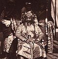
_of_Patiala_State_with_attendants,_by_Jean_Baptiste_Oscar_Malitte,_ca.1860.jpg)


See also
[edit]- Maharaja of Patiala
- Patiala State Monorail Trainways
- Political integration of India
- Phulkian sardars
- Nabha State
- Jind State
- Faridkot State
- Malaudh
- Bhadaur
- Kaithal
- Cis-Sutlej states
- Nanu Singh Saini
- 85 (Patiala) Field Battery
Notes
[edit]- ^ 1931-1941: Including Ad-Dharmis
References
[edit]- ^ a b c Imperial gazetteer of India. Vol. XX Pardi to Pusad. 1908. pp. 40, 42.
- ^ a b c d Punjab District and State Gazetteers: Part A]. Part 1. Punjab Government Press. 1900. pp. 46–52. Archived from the original on 20 June 2024. Retrieved 13 June 2024.
- ^ a b c d e f g h i j k l m n o p q r s t u v w x y z aa ab ac ad ae af Truhart, Peter (2017). Regents of Nations: Asia, Australia-Oceania, Part 2 (Reprint ed.). Walter de Gruyter. pp. 1398–1399. ISBN 9783111616254.
- ^ Bond, J. W.; Wright, Arnold (2006). Indian States: A Biographical, Historical, and Administrative Survey. New Delhi: Asian Educational Services. pp. 232–242. ISBN 978-81-206-1965-4. Archived from the original on 20 June 2024. Retrieved 13 June 2024.
- ^ Kaur, Roopam Jasmeet; Idris, Mohammad (2011). "The Development of Education in Patiala District (1948-2001): A Gendered Analysis". Proceedings of the Indian History Congress. 72: 1460–1470. JSTOR 44145757.
- ^ a b c d e f g h i j k l m n o p Singh, Khushwant. "The 'People's Captain'". The Global Sikh Trail. Retrieved 16 August 2024.
- ^ Singh, Ganda (1990). Sardar Jassa Singh Ahluwalia. Patiala: Punjabi University. pp. 97–98.
- ^ a b c d e f g Massy, Charles Francis (1890). Chiefs and Families of Note in the Delhi, Jalandhar, Peshawar and Derajat Divisions of the Panjab. Allahabad: Pioneer Press. pp. 12–15.
- ^ Singh, Khushwant (15 February 2017). Captain Amarinder Singh: The People's Maharaja: An Authorized Biography. Hay House, Inc. ISBN 978-93-85827-44-0. Archived from the original on 20 June 2024. Retrieved 20 June 2024.
- ^ Panjab Past and Present. Part 2. Vol. 31. Patiala: Department of Punjab Historical Studies, Punjabi University. 2000. pp. 94–97. Archived from the original on 20 June 2024. Retrieved 20 June 2024.
- ^ "Panjab Past and Present".
{{cite journal}}: Cite journal requires|journal=(help) - ^ "Census of India 1901. [Vol. 17A]. Imperial tables, I-VIII, X-XV, XVII and XVIII for the Punjab, with the native states under the political control of the Punjab Government, and for the North-west Frontier Province". 1901. p. 34. JSTOR saoa.crl.25363739. Archived from the original on 28 January 2024. Retrieved 30 March 2024.
- ^ "Census of India 1911. Vol. 14, Punjab. Pt. 2, Tables". 1911. p. 27. JSTOR saoa.crl.25393788. Archived from the original on 9 January 2024. Retrieved 30 March 2024.
- ^ Kaul, Harikishan (1911). "Census Of India 1911 Punjab Vol XIV Part II". p. 27. Retrieved 30 March 2024.
- ^ "Census of India 1921. Vol. 15, Punjab and Delhi. Pt. 2, Tables". 1921. p. 29. JSTOR saoa.crl.25430165. Archived from the original on 26 March 2023. Retrieved 30 March 2024.
- ^ "Census of India 1931. Vol. 17, Punjab. Pt. 2, Tables". 1931. p. 277. JSTOR saoa.crl.25793242. Archived from the original on 31 October 2023. Retrieved 30 March 2024.
- ^ India Census Commissioner (1941). "Census of India, 1941. Vol. 6, Punjab". p. 42. JSTOR saoa.crl.28215541. Archived from the original on 2 October 2022. Retrieved 30 March 2024.
Further reading
[edit]- Chavan, Akshay (15 February 2019), "Hitler's Gift to The Maharaja of Patiala", Live History India
- Dhavan, Purnima (2011). When Sparrows Became Hawks: The Making of the Sikh Warrior Tradition, 1699-1799. Oxford University Press (US). ISBN 978-0199756551.
- Priscoli, Jerome Delli; Wolf, Aaron T. (2010). Managing and Transforming Water Conflicts. Cambridge University Press. ISBN 978-0521632164.
External links
[edit]| International | |
|---|---|
| National | |