On Sunday, Sept. 5, the center of the storm is churning in the central Atlantic Basin about 1,200 miles from Bermuda with maximum sustained winds of 125 miles per hour and higher gusts, making it a Category 3 storm.
Larry is the third major hurricane -- Cat 3 or higher -- in the Atlantic this hurricane season. It could hit Cat 4 strength with maximum winds of 140 by Labor Day on Monday, Sept. 6.
Impacts from Larry "will be far-reaching even though the storm may stay hundreds of miles away from the Atlantic beaches from Florida to Maine," said AccuWeather.
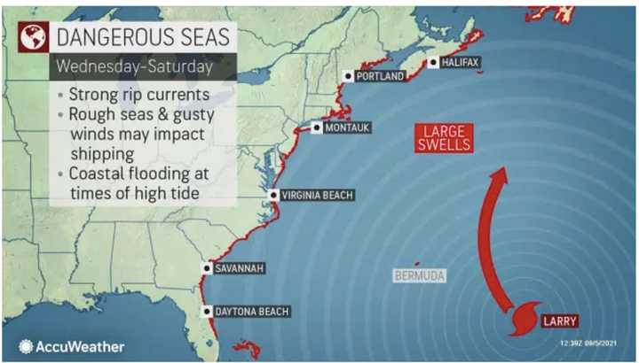
The storm is expected to bring strong rip currents, rough seas, and gusty winds, along with coastal flooding at times of high tide along the East Coast this week. (See the first image above.)
Current models keep it well off the US coast during its long-term track, with eventual landfall possible in Canada, but "significant swells will likely reach the eastern United States coastline after Labor Day," the National Hurricane Center.
Larry could approach Bermuda as a major hurricane on Thursday, Sept. 9. (For the latest projected path, see the second image above.)
"Swells were already reaching the northeast-facing coastlines of the Caribbean Islands and the southeastern-facing coastline of Bermuda and are forecast to spread northwestward this week," AccuWeather Senior Meteorologist Tyler Roys said.
But there's still uncertainty surrounding its path, and given its strength, and the uncertainty in predicting the speed and strength of hurricanes this season, it should be closely monitored.
This continues to be a developing story. Check back to Daily Voice for updates.
Click here to follow Daily Voice Yonkers and receive free news updates.

