File:Haiti und Dominikanische Republik - Gebietsentwicklung (mit Gebietszuständen).png
Jump to navigation
Jump to search

Size of this preview: 429 × 600 pixels. Other resolutions: 171 × 240 pixels | 343 × 480 pixels | 549 × 768 pixels | 732 × 1,024 pixels | 1,893 × 2,647 pixels.
Original file (1,893 × 2,647 pixels, file size: 621 KB, MIME type: image/png)
Captions
Captions
Add a one-line explanation of what this file represents
| Description |
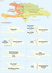
Deutsch: Gebietsentwicklung von Haiti
English: History of the teritorial changes of Haiti (Island of Hispaniola) |
| Date | see file history |
| Source | Own work, using File:Haiti location map.svg by Alexrk and File:Dominican Republic location map.svg by Alexrk |
| Author | Maximilian Dörrbecker (Chumwa) |
| Permission (Reusing this file) |
This file is licensed under the Creative Commons Attribution-Share Alike 2.0 Generic license.
|
| Other versions |
|

.png)


File history
Click on a date/time to view the file as it appeared at that time.
| Date/Time | Thumbnail | Dimensions | User | Comment | |
|---|---|---|---|---|---|
| current | 22:29, 16 March 2011 | | 1,893 × 2,647 (621 KB) | Chumwa (talk | contribs) | Korrektur: Republic d'Haïti → République d'Haïti |
| 21:23, 16 March 2011 |  | 1,893 × 2,647 (621 KB) | Chumwa (talk | contribs) | Kosmetik | |
| 20:35, 15 March 2011 |  | 1,893 × 2,647 (620 KB) | Chumwa (talk | contribs) | umgebaut, +Gonaïves | |
| 16:45, 13 March 2011 |  | 1,893 × 1,189 (403 KB) | Chumwa (talk | contribs) | {{Information |Description={{ de }} Gebietsentwicklung von Haiti {{ en }} History of the teritorial changes of Haiti |Author=Maximilian Dörrbecker (Chumwa) |Source={{own}}, using File:Haiti location map.svg by |
You cannot overwrite this file.
File usage on Commons
The following 12 pages use this file:
- User:Chumwa/Gallery
- File:Haiti - Gebietsentwicklung (mit Gebietszuständen).png (file redirect)
- File:Haiti und Dominikanische Republik - Gebietsentwicklung.png
- File:Haiti und Dominikanische Republik - Gebietsentwicklung (mit Gebietszuständen).png
- File:Hispaniola 1492-1697.png
- File:Hispaniola 1697-1795.png
- File:Hispaniola 1795-1806.png
- File:Hispaniola 1806-1808.png
- File:Hispaniola 1808-1820.png
- File:Hispaniola 1820-1822.png
- File:Hispaniola 1822-1844.png
- File:Hispaniola 1936-today.png
.png&redirect=no)
File usage on other wikis
The following other wikis use this file:
- Usage on de.wikipedia.org
- Usage on en.wikipedia.org
- Usage on fr.wikipedia.org
- Usage on ht.wikipedia.org
- Usage on hu.wikipedia.org
- Usage on nl.wikipedia.org
- Usage on pt.wikipedia.org
- Usage on ru.wikipedia.org
- Usage on zh.wikipedia.org
.png&oldid=823817226)