File:Counties of Croatia.png
From Wikimedia Commons, the free media repository
Jump to navigation
Jump to search
Counties_of_Croatia.png (487 × 480 pixels, file size: 17 KB, MIME type: image/png)
File information
Structured data
Captions
Captions
Add a one-line explanation of what this file represents
Summary
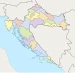
[edit]Map: Counties of Croatia. Taken from Croatian Wikipedia. Orginally uploaded by user Zmaj.
| No. | County | Official name | |
| Central Croatia | |||
|---|---|---|---|
| 1. | Zagreb | Zagrebačka županija | |
| 2. | Krapina-Zagorje | Krapinsko-zagorska županija | |
| 3. | Sisak-Moslavina | Sisačko-moslavačka županija | |
| 4. | Karlovac | Karlovačka županija | |
| 5. | Varaždin | Varaždinska županija | |
| 6. | Koprivnica-Križevci | Koprivničko-križevačka županija | |
| 7. | Bjelovar-Bilogora | Bjelovarsko-bilogorska županija | |
| 20. | Međimurje | Međimurska županija | |
| 21. | City of Zagreb | Grad Zagreb | |
| Istria, Northern seacoast and Mountainous Croatia | |||
| 8. | Primorje-Gorski Kotar | Primorsko-goranska županija | |
| 9. | Lika-Senj | Ličko-senjska županija | |
| 18. | Istria | Istarska županija | |
| Slavonia | |||
| 10. | Virovitica-Podravina | Virovitičko-podravska županija | |
| 11. | Požega-Slavonia | Požeško-slavonska županija | |
| 12. | Brod-Posavina | Brodsko-posavska županija | |
| 14. | Osijek-Baranja | Osječko-baranjska županija | |
| 16. | Vukovar-Syrmia | Vukovarsko-srijemska županija | |
| Dalmatia | |||
| 13. | Zadar | Zadarska županija | |
| 15. | Šibenik-Knin | Šibensko-kninska županija | |
| 17. | Split-Dalmatia | Splitsko-dalmatinska županija | |
| 19. | Dubrovnik-Neretva | Dubrovačko-neretvanska županija | |
Licensing
[edit]
|
Permission is granted to copy, distribute and/or modify this document under the terms of the GNU Free Documentation License, Version 1.2 or any later version published by the Free Software Foundation; with no Invariant Sections, no Front-Cover Texts, and no Back-Cover Texts. A copy of the license is included in the section entitled GNU Free Documentation License.http://www.gnu.org/copyleft/fdl.htmlGFDLGNU Free Documentation Licensetruetrue |
| This file is licensed under the Creative Commons Attribution-Share Alike 3.0 Unported license. | ||
| ||
| This licensing tag was added to this file as part of the GFDL licensing update.http://creativecommons.org/licenses/by-sa/3.0/CC BY-SA 3.0Creative Commons Attribution-Share Alike 3.0truetrue |
File history
Click on a date/time to view the file as it appeared at that time.
| Date/Time | Thumbnail | Dimensions | User | Comment | |
|---|---|---|---|---|---|
| current | 19:53, 23 April 2006 |  | 487 × 480 (17 KB) | Neoneo13 (talk | contribs) | |
| 13:40, 2 March 2006 |  | 487 × 480 (19 KB) | Neoneo13 (talk | contribs) | Map: Counties of Croatia. Taken from Croatian Wikipedia. Orginally uploaded by user Zmaj. Category:Maps of Croatia |
You cannot overwrite this file.
File usage on Commons
The following 3 pages use this file:
File usage on other wikis
The following other wikis use this file:
- Usage on ar.wikipedia.org
- Usage on bar.wikipedia.org
- Usage on ca.wikipedia.org
- Usage on da.wikipedia.org
- Usage on de.wikipedia.org
- Usage on eo.wikipedia.org
- Usage on eu.wikipedia.org
- Usage on frr.wikipedia.org
- Usage on fr.wikipedia.org
- Usage on gl.wikipedia.org
- Usage on hr.wikipedia.org
- Usage on ie.wikipedia.org
- Usage on lt.wikipedia.org
- Usage on nn.wikipedia.org
- Usage on no.wikipedia.org
- Usage on pt.wikipedia.org
- Usage on ro.wikipedia.org
- Usage on ru.wikipedia.org
- Usage on sk.wikipedia.org
- Usage on sr.wikipedia.org
- Usage on uk.wikipedia.org
- Usage on vec.wikipedia.org
- Usage on zh.wikipedia.org


