File:Berlin relief location map-names.png
Jump to navigation
Jump to search

Size of this preview: 729 × 599 pixels. Other resolutions: 292 × 240 pixels | 584 × 480 pixels | 934 × 768 pixels | 1,246 × 1,024 pixels | 1,400 × 1,151 pixels.
Original file (1,400 × 1,151 pixels, file size: 2.85 MB, MIME type: image/png)
Captions
Captions
Add a one-line explanation of what this file represents
| Description |
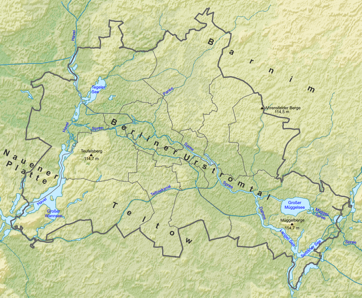
Deutsch: Positionskarte Berlin, Deutschland. Geographische Begrenzung der Karte: English: Location map Berlin, Germany. Geographic limits of the map: * N: 52,684707° N * S: 52,327157° N * W: 13,066864° O * E: 13,781318° O |
| Date | (UTC) |
| Source | |
| Author |
|
| This is a retouched picture, which means that it has been digitally altered from its original version. Modifications: Added some place names. The original can be viewed here: Berlin location map.svg:
|
This file is licensed under the Creative Commons Attribution-Share Alike 3.0 Unported, 2.5 Generic, 2.0 Generic and 1.0 Generic license.
- You are free:
- to share – to copy, distribute and transmit the work
- to remix – to adapt the work
- Under the following conditions:
- attribution – You must give appropriate credit, provide a link to the license, and indicate if changes were made. You may do so in any reasonable manner, but not in any way that suggests the licensor endorses you or your use.
- share alike – If you remix, transform, or build upon the material, you must distribute your contributions under the same or compatible license as the original.
Original upload log
[edit]
This image is a derivative work of the following images:
- File:Berlin_relief_location_map.png licensed with Cc-by-sa-3.0,2.5,2.0,1.0
- 2010-08-19T12:05:50Z Uwe Dedering 1400x1151 (2419455 Bytes) {{Information |Description={{de|Positionskarte [[w:de:Berlin|Berlin]], Deutschland. Geographische Begrenzung der Karte:}} {{en|Location map [[w:en:Berlin|Berlin]], Germany. Geographic limits of the map:}} * N: 52,684707° N *
- File:Berlin_location_map.svg licensed with Cc-by-sa-3.0,2.5,2.0,1.0
- 2010-06-13T13:38:15Z Alexrk2 1400x1151 (668238 Bytes) Fichtewiese zu Berlin
- 2010-05-03T20:16:35Z Alexrk2 1400x1151 (677608 Bytes) bissl generalisiert
- 2010-04-18T15:39:52Z Alexrk2 1400x1151 (883720 Bytes) Neu erstellt; Entzerrt, Projektion berichtigt, ein paar zusätzliche Flüsse, bebaute Gebiete erweitert
- 2009-02-02T11:22:39Z TUBS 4832x3848 (510201 Bytes) recolered Tempelhof and Tegel. Now matching Schönefeld. I.e: unpopulated area
- 2009-02-02T10:58:06Z TUBS 4832x3848 (509557 Bytes) +Tempelhof +Tegel. Color of populated areas adjusted
- 2009-02-02T09:43:15Z TUBS 4832x3848 (508193 Bytes) rvers aside border, populated areas now matching better the template for location maps
- 2009-01-30T22:12:20Z TUBS 4832x3848 (507677 Bytes) Cropped area
- 2009-01-30T22:09:54Z TUBS 7608x7068 (507772 Bytes) == Summary == {{Information |Description= {{de|Positionskarte [[w:de:Berlin|Berlin]], Deutschland. Geographische Begrenzung der Karte:}} {{en|Location map [[w:en:Berlin|Berlin]], Germany. Geographic limits of the map:}} * N:
Uploaded with derivativeFX
File history
Click on a date/time to view the file as it appeared at that time.
| Date/Time | Thumbnail | Dimensions | User | Comment | |
|---|---|---|---|---|---|
| current | 14:30, 24 August 2010 | | 1,400 × 1,151 (2.85 MB) | Sitacuisses (talk | contribs) | more names |
| 12:37, 24 August 2010 | 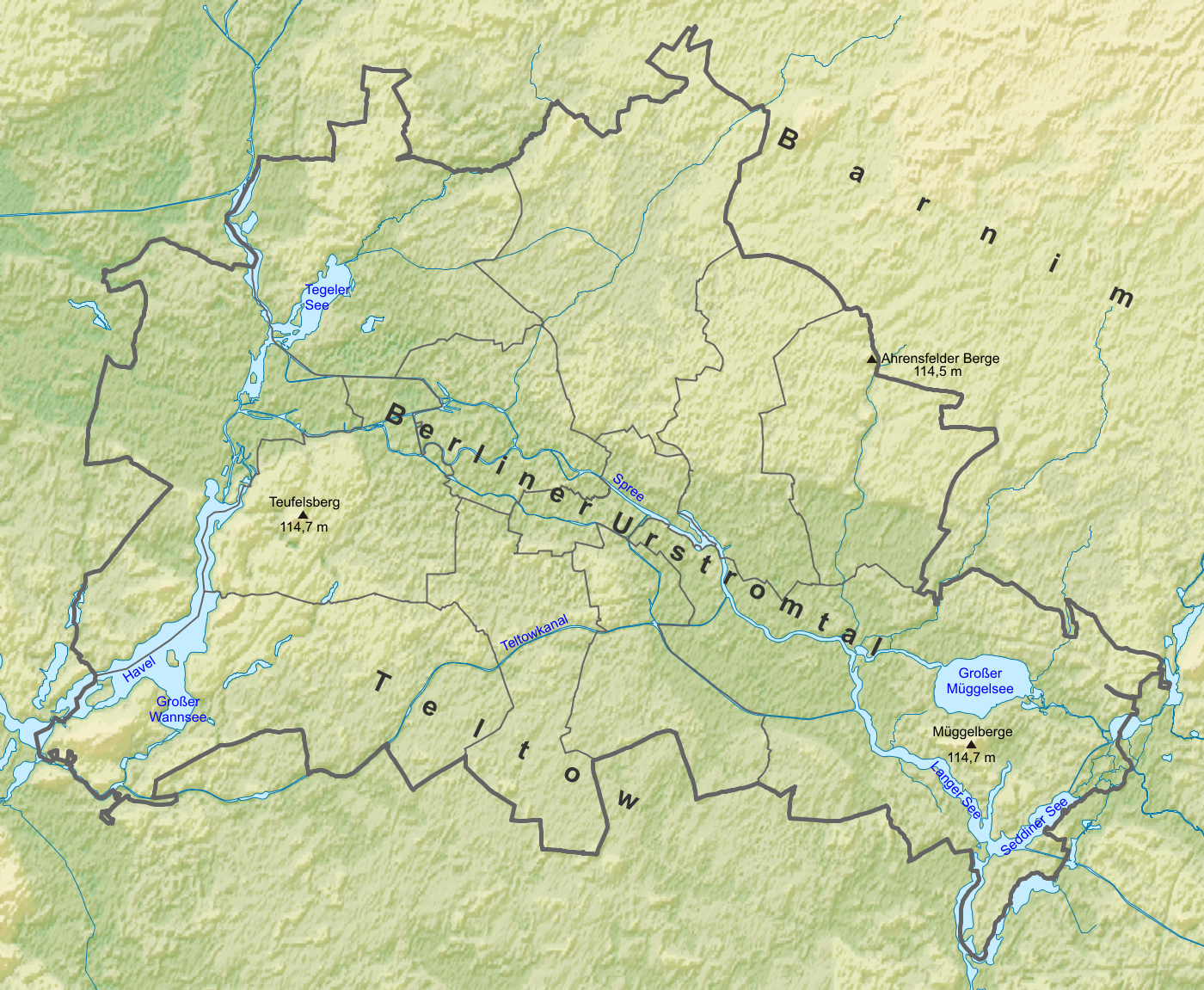 | 1,400 × 1,151 (2.84 MB) | Sitacuisses (talk | contribs) | Added names: Berliner Urstromtal, Barnim, Teltow | |
| 12:14, 24 August 2010 |  | 1,400 × 1,151 (2.22 MB) | Sitacuisses (talk | contribs) | {{Information |Description={{de|Positionskarte Berlin, Deutschland. Geographische Begrenzung der Karte:}} {{en|Location map Berlin, Germany. Geographic limits of the map:}} * N: 52,684707° N * S: 52,327157° N * W: 13,0668 |
You cannot overwrite this file.
File usage on Commons
There are no pages that use this file.
File usage on other wikis
The following other wikis use this file:
- Usage on af.wikipedia.org
- Usage on de.wikipedia.org
- Usage on fy.wikipedia.org
- Usage on nl.wikipedia.org