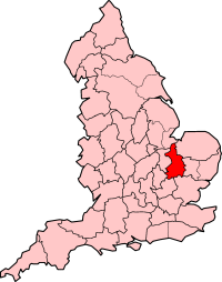
Category:Cambridgeshire and Isle of Ely
Jump to navigation
Jump to search
Ceremonial counties of England: Bedfordshire · Berkshire · Buckinghamshire · Cambridgeshire · Cheshire · Cornwall · Cumbria · Derbyshire · Devon · Dorset · Durham · East Riding of Yorkshire · East Sussex · Essex · Gloucestershire · Greater London · Greater Manchester · Hampshire · Herefordshire · Hertfordshire · Isle of Wight · Kent · Lancashire · Leicestershire · Lincolnshire · Merseyside · Norfolk · North Yorkshire · Northamptonshire · Northumberland · Nottinghamshire · Oxfordshire · Rutland · Shropshire · Somerset · South Yorkshire · Staffordshire · Suffolk · Surrey · Tyne and Wear · Warwickshire · West Midlands · West Sussex · West Yorkshire · Wiltshire · Worcestershire
City-counties: Bristol · City of London
Former historic counties: Cumberland · Huntingdonshire · London · Middlesex · North Riding of Yorkshire · Sussex · West Riding of Yorkshire · Westmorland · Yorkshire
Other former counties: Avon · Cambridgeshire and Isle of Ely · Cleveland · East Suffolk · Hereford and Worcester · Hexhamshire · Humberside · Huntingdon and Peterborough · Isle of Ely · Parts of Holland · Parts of Kesteven · Parts of Lindsey · Soke of Peterborough · West Suffolk
English: Cambridgeshire and Isle of Ely was a county in England.
former administrative county | |||||
| Upload media | |||||
| Instance of |
| ||||
|---|---|---|---|---|---|
| Location |
| ||||
| Start time |
| ||||
| End time |
| ||||
 | |||||
Media in category "Cambridgeshire and Isle of Ely"
The following 6 files are in this category, out of 6 total.
-
"A Map of the Great Levell, representing it as it lay drowned." (1662).jpg 4,671 × 4,086; 13.09 MB
-
"The Map of the Great Levell drained" (1662).jpg 4,666 × 3,648; 12.37 MB
-
Arms of Cambridgeshire and Isle of Ely County Council.svg 1,026 × 776; 304 KB
-
EnglandCambridgeshireIsleOfEly.png 200 × 254; 24 KB
-
Historical Administrative Boundaries in Cambridgeshire.svg 1,000 × 1,000; 3.47 MB
-
Soham Mere Cambs 1667.jpg 453 × 486; 327 KB


