
Dacia was the land inhabited by the Dacians, its core in Transylvania, stretching to the Danube in the south, the Black Sea in the east, and the Tisza in the west. The Carpathian Mountains were located in the middle of Dacia. It thus roughly corresponds to present-day Romania, as well as parts of Moldova, Bulgaria, Serbia, Hungary, Slovakia, and Ukraine.

Serpent's Wall is an ancient system of earthworks (valla) located in the middle Dnieper Ukraine (Naddniprianshchyna) that stretch across primarily Kyiv Oblast, Ukraine. They seem to be similar in purpose and character to Trajan's Wall situated to the southwest in Bessarabia. The remaining ancient walls have a total length of 1,000 km and constitute less than 20% of the original wall system.
The Limes Germanicus, or 'Germanic Limes', is the name given in modern times to a line of frontier fortifications that bounded the ancient Roman provinces of Germania Inferior, Germania Superior and Raetia, dividing the Roman Empire and the unsubdued Germanic tribes from the years 83 to about 260 AD. The frontier used either a natural boundary such as a river or typically an earth bank and ditch with a wooden palisade and watchtowers at intervals, and a system of linked forts was built behind them.
Vallum is either the whole or a portion of the fortifications of a Roman camp. The vallum usually comprised an earthen or turf rampart (Agger) with a wooden palisade on top, with a deep outer ditch (fossa). The name is derived from vallus, and properly means the palisade which ran along the outer edge of the top of the agger, but is usually used to refer to the whole fortification.
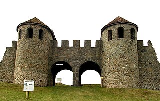
Porolissum was an ancient Roman city in Dacia. Established as a military fort in 106 during Trajan's Dacian Wars, the city quickly grew through trade with the native Dacians and became the capital of the province Dacia Porolissensis in 124. It is one of the largest and best-preserved archaeological sites in modern-day Romania from the Roman Era. It is 8 km away from the modern city of Zalău, in Moigrad-Porolissum village, Mirsid Commune, Sălaj County.
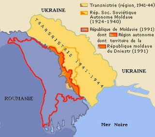
This is the history of Transnistria, officially the Pridnestrovian Moldavian Republic (PMR), an unrecognised breakaway state that is internationally recognised as part of Moldova. Transnistria controls most of the narrow strip of land between the Dniester river and the Moldovan–Ukrainian border, as well as some land on the other side of the river's bank.
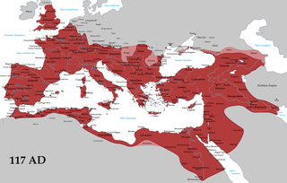
The borders of the Roman Empire, which fluctuated throughout the empire's history, were realised as a combination of military roads and linked forts, natural frontiers and man-made fortifications which separated the lands of the empire from the countries beyond.

Roman military borders and fortifications were part of a grand strategy of territorial defense in the Roman Empire, although this is a matter of debate. By the early 2nd century, the Roman Empire had reached the peak of its territorial expansion and rather than constantly expanding their borders as earlier in the Empire and Republic, the Romans solidified their position by fortifying their strategic position with a series of fortifications and established lines of defense. Historian Adrian Goldsworthy argues that the Romans had reached the natural limits which their military traditions afforded them conquest over and that beyond the borders of the early-to-mid Empire lay peoples whose military traditions made them militarily unconquerable, despite many Roman battle victories. In particular, Goldsworthy argues that the cavalry-based warfare of the Parthians, Sarmatians and Persians presented a major challenge to the expansion of Rome's infantry-based armies.

The Moesian Limes is the modern term given to a linked series of Roman forts on the northern frontier of the Roman province of Moesia along the Danube between the Black Sea shore and Pannonia and dating from the 1st century AD. It was the eastern section of the so-called Danubian Limes and protected the Roman provinces of Upper and Lower Moesia south of the river. The eastern section is often called the limes Scythiae minoris as it was located in the late Roman province of Scythia Minor.

Athanaric's Wall, also called Lower Trajan's Wall or Southern Trajan's Wall, was a fortification line probably erected by Athanaric, between the banks of river Gerasius and the Danube to the land of Taifali. Most probably, Athanaric's Wall has reused the old Roman limes called Limes Transalutanus.
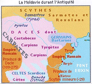
The Upper Trajan's Wall is the modern name given to a fortification located in the central area of modern Moldavia. Some scholars consider it to be of Roman origin, while others think it was built in the third/fourth century by the Germanic Greuthungi to defend their borders against the Huns. It may also have been called Greuthungian Wall in later Roman accounts, but this is uncertain owing to a single polysemic manuscript occurrence in the works of Ammianus Marcellinus.
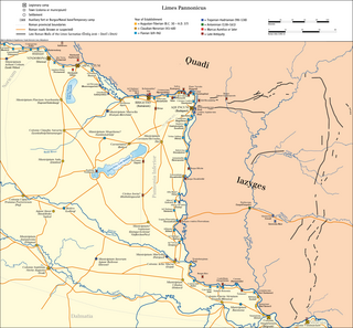
The Devil's Dykes, also known as the Csörsz árka or the Limes Sarmatiae, are several lines of Roman fortifications built mostly during the reign of Constantine the Great (306–337), stretching between today's Hungary, Romania and Serbia.
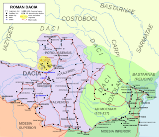
Limes Transalutanus is the modern name given to a fortified frontier system of the Roman Empire, built on the western edge of Teleorman's forests as part of the Dacian Limes in the Roman province of Dacia, modern-day Romania.

Brazda lui Novac is a Roman frontier system in present-day Romania, known also as Constantine's Wall. It is believed by some historians to border Ripa Gothica.
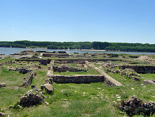
Capidava was originally an important Geto-Dacian centre on the right bank of the Danube. After the Roman conquest, it became a civil and military centre in the province of Moesia Inferior and part of the defensive frontier system of the Moesian Limes along the Danube.

Noviodunum ad Istrum was a Roman city that developed around the legionary fortress and naval port near the present town of Isaccea. It was in the Roman province of Moesia and was the headquarters of the Roman Danube fleet located on the lower Danube and, from the 4th century AD, the headquarters of the Legio I Iovia (Scythica).

The castra of Pietroasele was a Roman fort in Roman Dacia located in the centre of Pietroasele (Romania). It was built under Trajan after Trajan's Dacian Wars in about 106 AD but abandoned at the beginning of Hadrian's reign when Wallachia was given up to the Roxolani. It was used again at the beginning of the 3rd century in the reign of Caracalla. It was rebuilt by Constantine the Great after his victory over the Goths in 328 when Constantine created the Constantine Wall of the Dacian Limes. It was abandoned in the same century.
The Danubian Limes, or Danube Limes, refers to the Roman military frontier or limes which lies along the River Danube in the present-day German state of Bavaria, in Austria, Slovakia, Hungary, Croatia, Serbia, Bulgaria and Romania.

The Dacian Limes is the generic modern term given to a collection of ramparts and linked series of Roman forts on the frontiers of the Roman province of Dacia dating from the early 2nd century AD. They ran for about 1,000 km and included the:


