Plik:U.S. Territorial Acquisitions.png

Rozmiar pierwotny (1536 × 1038 pikseli, rozmiar pliku: 1,11 MB, typ MIME: image/png)
| Plik U.S. Territorial Acquisitions.png znajduje się w Wikimedia Commons – repozytorium wolnych zasobów. Dane z jego strony opisu znajdują się poniżej. |
Opis
| Opis |
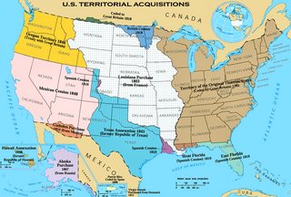
English: The Territorial acquisitions of the United States, such as the Thirteen Colonies, the Louisiana Purchase, the Oregon Country, the Mexican Cession, and so on. |
|||
| Data | 2017, 2022 | |||
| Źródło | National Atlas of the United States [1] | |||
| Autor | United States federal government (en:User:pink and White converted it from JPEG to PNG and retouched it) | |||
| Licencja (Ponowne użycie tego pliku) |
|
|||
| Inne wersje |
Prace pochodne od tego pliku: |

|
Ta ilustracja ma także wersję wektorową („SVG”).
Zaleca się wykorzystywanie w galeriach dostępnej wersji wektorowej zamiast obecnej. File:U.S. Territorial Acquisitions.png → File:Aquired Lands of the US.svg
Więcej o grafice wektorowej przeczytasz w artykule Przenoszenie grafik Commons do formatu SVG. Dostępna jest także informacja o obsłudze grafik SVG przez MediaWiki. |
 |
(Uploaded using CommonsHelper or PushForCommons)
Possible Errors
There is concern that this map could have errors. For discussion, please don't see the en:Image talk:U.S. Territorial Acquisitions.png talk page.
== Oryginalny rejestr przesyłania == Originally from en.wikipedia; description page is (was) here * 22:30, 31 May 2006 [[:en:User:Black and White|Black and White]] 1536×1038 (1,164,091 bytes) <span class="comment">('''{{PAGENAME}}''' == Summary == {{main|United States territorial acquisitions}} This image depicts the United States' historic acquisitions of territories, such as the Thirteen Colonies, the Louisiana Purchase, British and Spanish Cession, and so on. =)</span>
Historia pliku
Kliknij na datę/czas, aby zobaczyć, jak plik wyglądał w tym czasie.
| Data i czas | Miniatura | Wymiary | Użytkownik | Opis | |
|---|---|---|---|---|---|
| aktualny | 09:43, 6 gru 2020 | | 1536 × 1038 (1,11 MB) | Petri Krohn | Reverted to original high-resolution version. If you have issues with terminology of the British Isles, at least keep the resolution of the map. |
| 03:52, 10 sty 2016 |  | 922 × 623 (574 KB) | Elevatorrailfan | The United Kingdom came into existence in 1801. | |
| 04:22, 16 kwi 2013 |  | 1536 × 1038 (1,11 MB) | Futurist110 | Reverted to version as of 17:56, 13 June 2012 | |
| 01:55, 16 kwi 2013 |  | 3300 × 2550 (702 KB) | Futurist110 | Higher resolution. | |
| 19:56, 13 cze 2012 |  | 1536 × 1038 (1,11 MB) | Phoenix B 1of3 | Reverted to version as of 15:36, 16 September 2006 Undoing own revision per talk page | |
| 19:26, 13 cze 2012 |  | 1536 × 1038 (1,12 MB) | Phoenix B 1of3 | color puerto rico to differentiate it from mexico and cuba. | |
| 17:36, 16 wrz 2006 |  | 1536 × 1038 (1,11 MB) | Shizhao | {{Information| |Description= United States Territorial Acquisitions == Summary == {{main|United States territorial acquisitions}} This image depicts the United States' historic acquisitions of territories, such as the Thirteen Colonies, the Louisiana Pur |
Lokalne wykorzystanie pliku
Następujące strony korzystają z tego pliku:
Globalne wykorzystanie pliku
Ten plik jest wykorzystywany także w innych projektach wiki:
- Wykorzystanie na af.wikipedia.org
- Wykorzystanie na am.wikipedia.org
- Wykorzystanie na ar.wikipedia.org
- Wykorzystanie na arz.wikipedia.org
- Wykorzystanie na ast.wikipedia.org
- Wykorzystanie na az.wikipedia.org
- Wykorzystanie na bg.wikipedia.org
- Wykorzystanie na bn.wikipedia.org
- Wykorzystanie na ca.wikipedia.org
- Wykorzystanie na ckb.wikipedia.org
- Wykorzystanie na cs.wikipedia.org
- Wykorzystanie na da.wikipedia.org
- Wykorzystanie na de.wikipedia.org
- Wykorzystanie na de.wikiversity.org
- Wykorzystanie na dtp.wikipedia.org
- Wykorzystanie na el.wikipedia.org
- Wykorzystanie na en.wikipedia.org
- Louisiana Purchase
- Oregon Trail
- Indian Territory
- History of the United States
- Manifest destiny
- Gadsden Purchase
- Alaska Purchase
- American imperialism
- Adams–Onís Treaty
- U.S. territorial sovereignty
- Oregon Treaty
- Mexican Cession
- Historical regions of the United States
- Eastern United States
- Treaty of 1818
- Convention of 1800
- United States
- History of Western civilization
- User talk:Black and White
Pokaż listę globalnego wykorzystania tego pliku.