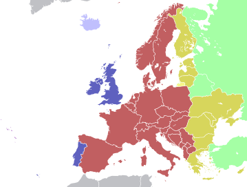
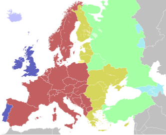
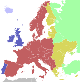
ဖိုင်:Time zones of Europe.svg

Size of this PNG preview of this SVG file: ၅၁၂ × ၅၂၃ ပစ်ဇယ်. အခြား ပုံရိပ်ပြတ်သားမှု: ၂၃၅ × ၂၄၀ ပစ်ဇယ် | ၄၇၀ × ၄၈၀ ပစ်ဇယ် | ၇၅၂ × ၇၆၈ ပစ်ဇယ် | ၁၀၀၂ × ၁၀၂၄ ပစ်ဇယ် | ၂၀၀၅ × ၂၀၄၈ ပစ်ဇယ်။
မူရင်းဖိုင် (SVG ဖိုင်, ၅၁၂ × ၅၂၃ pixels ကို အကြံပြုသည်, ဖိုင်အရွယ်အစား - ၃၃၂ KB)
ဖိုင်မှတ်တမ်း
ဖိုင်ကို ယင်းနေ့စွဲ အတိုင်း မြင်နိုင်ရန် နေ့စွဲ/အချိန် တစ်ခုခုပေါ်တွင် ကလစ်နှိပ်ပါ။
| နေ့စွဲ/အချိန် | နမူနာပုံငယ် | မှတ်တမ်း ဒိုင်မန်းရှင်းများ | အသုံးပြုသူ | မှတ်ချက် | |
|---|---|---|---|---|---|
| ကာလပေါ် | ၁၃:၁၀၊ ၁၂ အောက်တိုဘာ ၂၀၂၃ |  | ၅၁၂ × ၅၂၃ (၃၃၂ KB) | 3.kor0p | Reverted to version as of 23:01, 2 August 2021 (UTC). Crimea is part of Ukraine |
| ၀၁:၅၈၊ ၁၉ နိုဝင်ဘာ ၂၀၂၂ |  | ၅၉၃ × ၆၀၆ (၆၆၇ KB) | M.Bitton | Reverted to version as of 13:51, 5 April 2022 (UTC): I suggest you read COM:OVERWRITE | |
| ၀၈:၄၈၊ ၁၇ နိုဝင်ဘာ ၂၀၂၂ |  | ၅၉၃ × ၆၀၆ (၆၆၆ KB) | Рагин1987 | Small correction | |
| ၀၈:၄၄၊ ၁၇ နိုဝင်ဘာ ၂၀၂၂ |  | ၅၉၃ × ၆၀၆ (၆၆၆ KB) | Рагин1987 | Extended map | |
| ၁၃:၅၁၊ ၅ ဧပြီ ၂၀၂၂ |  | ၅၉၃ × ၆၀၆ (၆၆၇ KB) | Seryo93 | Reverted to version as of 06:42, 7 August 2021 (UTC) | |
| ၁၀:၂၂၊ ၂၇ မတ် ၂၀၂၂ |  | ၅၁၂ × ၅၂၃ (၃၃၂ KB) | Grudzio240 | Improvement of time zone in Ukraine according to maps in independent sources e.g. https://maps.lib.utexas.edu/maps/world_maps/time_zones_ref_2015.pdf or https://www.cia.gov/the-world-factbook/static/31913c20666d022fa1315bd444553f8d/world_time.pdf | |
| ၀၆:၄၂၊ ၇ ဩဂုတ် ၂၀၂၁ |  | ၅၉၃ × ၆၀၆ (၆၆၇ KB) | Seryo93 | Reverted to version as of 21:12, 2 August 2021 (UTC) the longstanding consensus is for an actually observed (de facto) time | |
| ၂၃:၀၁၊ ၂ ဩဂုတ် ၂၀၂၁ |  | ၅၁၂ × ၅၂၃ (၃၃၂ KB) | ThebeOkonma | Reverted to version as of 19:48, 2 August 2021 (UTC) - Correcting map error: Crimea is part of Ukraine | |
| ၂၁:၁၂၊ ၂ ဩဂုတ် ၂၀၂၁ |  | ၅၉၃ × ၆၀၆ (၆၆၇ KB) | Ymblanter | Reverted to version as of 20:19, 16 April 2021 (UTC) see talk page, the user has been warned | |
| ၁၉:၄၈၊ ၂ ဩဂုတ် ၂၀၂၁ |  | ၅၁၂ × ၅၂၃ (၃၃၂ KB) | ThebeOkonma | Reverted to version as of 12:52, 16 April 2021 (UTC) - Correcting map error: Crimea is part of Ukraine |
ဖိုင်သုံးစွဲမှု
အောက်ပါ 6 စာမျက်နှာများ သည် ဤဖိုင်ကို အသုံးပြုထားသည်:
ဂလိုဘယ် ဖိုင်သုံးစွဲမှု
အောက်ပါ အခြားဝီကီများတွင် ဤဖိုင်ကို အသုံးပြုထားသည်-
- af.wikipedia.org တွင် အသုံးပြုမှု
- ar.wikipedia.org တွင် အသုံးပြုမှု
- arz.wikipedia.org တွင် အသုံးပြုမှု
- ast.wikipedia.org တွင် အသုံးပြုမှု
- ban.wikipedia.org တွင် အသုံးပြုမှု
- ba.wikipedia.org တွင် အသုံးပြုမှု
- be.wikipedia.org တွင် အသုံးပြုမှု
- bg.wikipedia.org တွင် အသုံးပြုမှု
- bn.wikipedia.org တွင် အသုံးပြုမှု
- ইউটিসি±০০:০০
- মধ্য ইউরোপীয় সময়
- টেমপ্লেট:ইউরোপের সময় অঞ্চল
- ইউটিসি+০১:০০
- গ্রিনিচ মান সময়
- ইউটিসি+০২:০০
- ইউটিসি+০৩:০০
- পূর্ব ইউরোপীয় সময়
- পশ্চিম ইউরোপীয় সময়
- মধ্য ইউরোপীয় গ্রীষ্মকালীন সময়
- কালিনিনগ্রাদ সময়
- মস্কো সময়
- ব্রিটিশ গ্রীষ্মকালীন সময়
- পূর্ব ইউরোপীয় গ্রীষ্মকালীন সময়
- তুরস্ক সময়
- পশ্চিম ইউরোপীয় গ্রীষ্মকালীন সময়
- bs.wikipedia.org တွင် အသုံးပြုမှု
ဤဖိုင်ကို အခြားနေရာများတွင် အသုံးပြုထားမှုများအား ကြည့်ရှုရန်။


