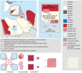
Dosiero:Venezuela - Yaracuy - Veroes.svg

Bildo en pli alta difino (SVG-dosiero, 512 × 448 rastrumeroj, grandeco de dosiero: 1,86 MB)
| Jen dosiero de la Wikimedia-Komunejo. La priskribo en ties priskriba paĝo estas montrata suben.
|
Enhavo
Resumo
![]() This SVG map is part of a locator map series applying the widespread location map scheme. Please see root category to browse for more.
This SVG map is part of a locator map series applying the widespread location map scheme. Please see root category to browse for more.
Locator maps design recommendations ▼ | |
|---|---|
Principles
Design Guidelines are based on ▸location map design of the German map shop (in German). It's preferable to derive new locator maps from existing location maps. Please keep both size and ratio in this case. Thus the new locator maps may still be applied as location map (▸Guide). Marker color is supposed to be darkred. Waterbodies may be transparent, to show other objects better. Please be aware that this guide is only a recommendation. It’s not an inevitable law!
Highlight small areas
“Remote” areas and mini maps
Mini maps show where the depicted area actually is situated. Check out ▸Vorlage:Positionskarte+ (in German) and ▸Modèle:Carte en coin (in French) of how to insert a mini map in virtually every map.
Disputed areas
Greyed special objects
Backgrounds
|
Map legend
- C12836 → Marked administrative territory
- FDFBEA → Marked state/province
- F6E1B9 → Other state/provinces of Venezuela
- 656564 → Lines/boundaries
Mini map legend
- C12836 → Marked state/province, and red circle
- FDFBEA → Rest of Venezuela
- DFDFDF → Other countries
- 656564 → Lines/boundaries
- C7E7FB → Water
- 000000 → Mini map border box
Geographic limits of the map (EPSG:4326)
- N: 10.8050
- S: 9.7751
- W: 69.3702
- E: 68.1746
Permesiloj:
| PriskriboVenezuela - Yaracuy - Veroes.svg |
English: Locator map of Municipio Veroes; in Yaracuy, Venezuela |
|||||||||
| SVG genesis InfoField | Ĉi tiu dosiero estas kreita per Adobe Illustrator. |
|||||||||
| Dato | ||||||||||
| Fonto | OpenStreetMap data, extracted via QGIS software. | |||||||||
| Kreinto |
OpenStreetMap contributors |
|||||||||
| Permeso (Reuzo de la dosiero) |
OpenStreetMap data is available under the Open Database License (details). Standard style map tiles are licensed as ODbL Produced Works.
|
|||||||||
| Geotemporal data | ||||||||||
| Bounding box |
|
|||||||||
| Boundaries geometry from OpenStreetMap has been simplified to optimize its indexing in Wikimedia projects. The boundaries lines shown in this image may be of lower quality than those shown in OpenStreetMap project, or in real life. |
Titoloj
Eroj prezentitaj en ĉi tiu dosiero
montras
Iu valoro sen Vikidatumoj ero
29 aŭg. 2017
image/svg+xml
Dosierhistorio
Alklaku iun daton kaj horon por vidi kiel la dosiero tiam aspektis.
| Dato/Horo | Bildeto | Grandecoj | Uzanto | Komento | |
|---|---|---|---|---|---|
| nun | 17:59, 26 jul. 2023 |  | 512 × 448 (1,86 MB) | Wguayana | OpenStreetMap 2023 data |
| 23:11, 29 aŭg. 2017 |  | 685 × 638 (123 KB) | Milenioscuro | User created page with UploadWizard |
Dosiera uzado
La jena paĝo ligas al ĉi tiu dosiero:
Suma uzado de la dosiero
La jenaj aliaj vikioj utiligas ĉi tiun dosieron:
- Uzado en es.wikipedia.org
- Uzado en fr.wikipedia.org
- Uzado en it.wikipedia.org
- Uzado en nl.wikipedia.org
- Uzado en pt.wikipedia.org
- Uzado en www.wikidata.org
- Uzado en zh-min-nan.wikipedia.org
- Uzado en zh.wikipedia.org
Metadatumoj
Ĉi tiu dosiero entenas aldonan informon, probable aldonitan de la diĝita fotilo aŭ skanilo uzita por ĝin krei aŭ diĝitigi. Se la dosiero estas modifita disde sia originala stato, detaloj povas ne ĝuste priskribi tiun modifitan bildon.
| Mallonga titolo | Municipio Veroes - Yaracuy - Venezuela |
|---|---|
| Larĝeco | 100% |
| Alteco | 100% |


