
Saba (island)
| |||
| Motto: "Remis Velisque." meaning "With oars and sails". | |||
| Languages | Dutch (official); English predominates | ||
| Capital | The Bottom | ||
| Area - Total - % water |
13 km² (5 sq. miles) N/A | ||
| Population - Total (2004) - Density |
1,424 104 inh. per km² | ||
| UTC | -4 | ||
| Anthem | "Saba you rise from the ocean" | ||

Saba (pronounced "SAY-ba") is the smallest island of the Netherlands Antilles, located at longitude 63.13 degrees West, latitude 17.38 degrees North. It consists largely of the dormant volcano, Mount Scenery (888 m), the highest point of the Kingdom of the Netherlands.
Saba has a land area of 13 km² (5 sq. miles). At the 2001 Netherlands Antilles census, the population was 1,349 inhabitants, which means a population density of 104 inh. per km². In 2004 the population was estimated at 1,424 inhabitants.
Its current major settlements include The Bottom, Windwardside, Hell's Gate and St. Johns. Despite the island's Dutch affiliation, English is the principal language spoken on the island and has been used in its school system since 1986.
Saba is home to the Saba University School of Medicine, which was established by American expatriates in coordination with the Netherlands government. The school adds as many as 300 residents when classes are in session, and it is the prime educational attraction. It is also the major provider of healthcare for local residents.
History
Christopher Columbus is said to have sighted Saba on November 13, 1493, but did not land. In 1632 a group of shipwrecked Englishmen landed upon Saba; they stated they found the island uninhabited when they were retrieved by others. In 1635 a stray Frenchman claimed Saba for Louis XIII of France and around the year 1640, the Dutch West India Company sent people from the neighbouring island of St. Eustatius to colonize the island. The Netherlands finally took possession of Saba in 1816 after a spell of British occupation during the Napoleonic era.
Through the 17th and 18th centuries its major industries were sugar and rum, and, later, fishing. In the 1600s Saba was believed to be a favorable hideout for Jamaican pirates.
The remains of the 1640 settlements can be found on the west side at Tent Bay.
Geography & environment
Of note in The Bottom area, are 800 steps carved from stone, to go from Ladder Bay to The Bottom. Everything was carried to the island by hand until the later 20th century.
There is one road, brilliantly called "The Road". Its construction was masterminded by Josephus Lambert Hassell who, despite the common opinion of Dutch and Swiss engineers, believed that a road could be built. He took a correspondence course in civil engineering, and started building the road with a crew of locals in 1938. After five years of work the first section of the road, from Fort Bay to The Bottom, was completed. It wasn't until 1947 however, that the first motorvehicle arrived. In 1951 the road to Windwardside and St. Johns was opened, and in 1958 the road was completed. Driving "the road" is considered to be a daunting occasion, and the curves in Windwardside are extremely difficult.
In 1963 the island had built a 400 metre landing strip for easier trips to the island by flight: Juancho E. Yrausquin Airport. It is one of the shortest commercial runways in the world, and as such, only three models of airplane are approved for landing. Consistent air service from St. Maarten is, as of 2006, available through Winward Island Airways (Winair). In 1972 a pier was completed in Fort Bay to access the island and has made it easier for visitors to come there. Travel provided by the saba ferry Dawn II.
The environment of Saba is usually a woodland forest full of ferns and damp soil. There used to be forests of Mahogany trees until a hurricane in the 1960's broke all of the trees. The Mahogany trees are considered at risk of going extinct on the island. Visitors refer to Saba's forests as "the Elfin Forest" because of its high altitude mist and mossy appearance. Since then there has been a woodland reserve created and aptly named "Elfin Forest Reserve". Saba's lush plant and animal wildlife are diverse and are looked after by the Saba Conservation Foundation.
4.3 km southwest of Saba is the Saba Bank, a large submerged atoll of rich biodiversity.
People and culture
The people of Saba come from around the world. Historically, the island was traded among the many European nations that fought for power in the region. Slaves were also imported to work on Saba. Both English and Dutch are used on the island and even taught in schools. In more recent years immigrants have become an important part of the population.
The island's relatively small size has led to a fairly small number of island families. This means that many last names are shared around the island. Many Sabans also live in relatively small villages and are Catholic by faith.
Economy & tourism
Saba lace (also known as "Spanish work") was a major export of Saba. In the 1870s, as a young lady, Mary Gertrude Hassell Johnson was sent to a Caracas convent for study - where she learned the craft. The lacework spread through the island. Ladies would copy addresses of businesses off of shipping containers from the United States, and write to the employees. Often they would get orders for the lacework, and it started a considerable cottage industry.
The island of Saba is known today for tourism and ecotourism. Scuba diving, climbing and hiking. The scuba diving in particular is deep and somewhat challenging; even though Saba is a small island it actually supports not one, but two Hyperbaric chambers in case of diving emergencies. There are few anchorages, and a small airport with service from St. Maarten. There is also ferry service from St. Maarten. The Dawn II travels to Saba three times a week. Saba's brilliantly colorful and pristine coral life make it one of the most sublime places to scuba dive in the world. Many attribute the underwater life's purity to the island's remoteness and the caring of the people.
Saba is known as the "Unspoiled Queen"
Gallery
-
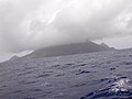 Saba, as seen from the east
 -
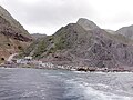 Saba's only port
 -
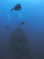 Underwater pinnacle
 -
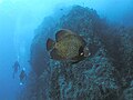
 Large Nassau Grouper at The Pinnacle
 -
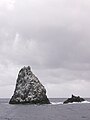 Diamond Rock
 -
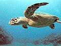 Hawksbill Turtle
 -
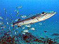 Great Barracuda and Jacks, Diamond Rock
 -
 Divers and French Angelfish next to Diamond Rock
 -
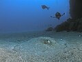 Divers and Southern Stringray next to Diamond Rock


