
Spišské Podhradie
Spišské Podhradie | |
|---|---|
Town | |
 View of Spišské Podhradie and Spiš Castle in the background | |
 Coat of arms | |
 Spišské Podhradie Location of Spišské Podhradie in Slovakia | |
| Coordinates: 49°00′00″N 20°45′06″E / 49.00000°N 20.75167°E | |
| Country | Slovakia |
| Region | Prešov |
| District | Levoča |
| First mentioned | 1249 |
| Government | |
| • Mayor | MVDr. Michal Kapusta |
| Area | |
| • Total | 24.94[2] km2 (9.63[2] sq mi) |
| Elevation | 448[3] m (1,470[3] ft) |
| Population (2021) | |
| • Total | 3,775[1] |
| Postal code | 053 04[3] |
| Area code | +421 53[3] |
| Car plate | LE |
| Website | www.spisskepodhradie.sk |
Spišské Podhradie (Hungarian: Szepesváralja) is a town in Spiš in the Prešov Region of Slovakia. Its population is around 4,000.
Spišské Podhradie is situated at the foot of the hill of Spiš Castle. It had a Zipser German settlement, with its own church and priest, in 1174. Just above, and adjacent to, the town is the ecclesiastical settlement of Spišská Kapitula (hence an old German name Kirchdorf, meaning "church town"). The town contains a number of Renaissance merchants' houses. It also has one of the few remaining synagogue buildings (now disused) in the region. The Sivá Brada cold water spring is located nearby.
Twin towns — sister cities
Spišské Podhradie is twinned with:
 Głogów Małopolski, Poland
 Pinetop-Lakeside, Arizona, United States
- Show Low, Arizona, United States
 Vrbové, Slovakia
Pictures
-
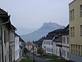 Road in Spišská Kapitula with Spiš Castle above
 -
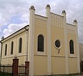 Synagogue at Spišské Podhradie
 -
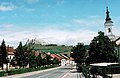 Town center and Spiš Castle above


References
- ^ "Počet obyvateľov podľa pohlavia - obce (ročne)". www.statistics.sk (in Slovak). Statistical Office of the Slovak Republic. 2022-03-31. Retrieved 2022-03-31.
- ^ a b "Hustota obyvateľstva - obce [om7014rr_ukaz: Rozloha (Štvorcový meter)]". www.statistics.sk (in Slovak). Statistical Office of the Slovak Republic. 2022-03-31. Retrieved 2022-03-31.
- ^ a b c d "Základná charakteristika". www.statistics.sk (in Slovak). Statistical Office of the Slovak Republic. 2015-04-17. Retrieved 2022-03-31.
- ^ a b "Hustota obyvateľstva - obce". www.statistics.sk (in Slovak). Statistical Office of the Slovak Republic. 2022-03-31. Retrieved 2022-03-31.
External links
| International | |
|---|---|
| National | |
| Geographic | |
This Prešov Region geography article is a stub. You can help Wikipedia by expanding it. |