
Cisco, Utah: Difference between revisions
m Undid revision 928155278 by 2601:601:4500:2B60:FC08:B27D:658E:5605 (talk) edit was malformed and broke a citation template |
Corrected inaccuracies Tags: Mobile edit Mobile web edit |
||
| Line 51: | Line 51: | ||
|population_footnotes = |
|population_footnotes = |
||
|pop_est_as_of = 2019 |
|pop_est_as_of = 2019 |
||
|population_est = |
|population_est = 12<ref>https://www.eileenmuza.org/</ref> |
||
|population_density_km2 = auto |
|population_density_km2 = auto |
||
| Line 75: | Line 75: | ||
}} |
}} |
||
'''Cisco''' is a [[ghost town]] in [[Grand County, Utah|Grand County]], [[Utah]], United States near the junction of [[Utah State Route 128|State Route 128]] (SR‑128) and [[Interstate 70 in Utah|Interstate 70]] (I‑70). |
'''Cisco''' is a [[ghost town]] in [[Grand County, Utah|Grand County]], [[Utah]], United States near the junction of [[Utah State Route 128|State Route 128]] (SR‑128) and [[Interstate 70 in Utah|Interstate 70]] (I‑70). |
||
==History== |
==History== |
||
Revision as of 05:12, 27 November 2019
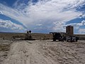
Cisco, Utah | |
|---|---|
 Buildings in Cisco | |
 Cisco Location within the state of Utah  Cisco Cisco (the United States) | |
| Coordinates: 38°58′12″N 109°19′14″W / 38.97000°N 109.32056°W | |
| Country | United States |
| State | Utah |
| County | Grand |
| Population (2019) | |
| • Total | 12 |
| • Estimate (2019) | 12[1] |
| Time zone | UTC-7 (Mountain (MST)) |
| • Summer (DST) | UTC-6 (MDT) |
Cisco is a ghost town in Grand County, Utah, United States near the junction of State Route 128 (SR‑128) and Interstate 70 (I‑70).
History
The town started in the 1880s as a saloon and water-refilling station for the Denver and Rio Grande Western Railroad. As work crews and, later, travelers came through, stores, hotels and restaurants sprang up to accommodate them. Nearby cattle ranchers and sheep herders in the Book Cliffs north of town began using Cisco as a livestock and provisioning center. Around the turn of the 20th century, over 100,000 sheep were sheared at Cisco before being shipped to market. After oil and natural gas were discovered, people began traveling more and Cisco continued to grow. The town's decline coincided with the demise of the steam locomotive. A declining economy crashed when Interstate 70 was built, bypassing Cisco.[2]
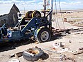
The town site contains many relics of a typical old west railroad town. Cisco survived long enough into the 20th century to be assigned a ZIP Code, 84515.[3] The ghost town's easy access and proximity to the freeway have lured vandals. The relics are heavily damaged and the town is littered with abandoned vehicles. While Cisco had no permanent residents for many years, their are many known shale oil deposits around Cisco, and efforts have been made over the years to extract this shale leading to the town having a few migrant residents working for the oil drilling firms involved.
In the 2010s, Eileen Muza started an artist residency in Cisco that has gained some attention in the artist community.[4]
Mining
Oil and natural gas were discovered near Cisco in 1924. In 2005, new oil and gas wells were drilled in the nearby Cisco Oil Field by a Reno, Nevada-based company.[5] Newly drilled wells can be seen next to the railroad track and around the freeway. Cisco Mayor Dan Vanover was also an oil and turquoise miner from 1963 until his death in 1986.
Transportation
Cisco is along the former routing of US‑6/US‑50. The town was bypassed with the completion of I‑70 through the area but is still accessible by way of Exit 204. Cisco is listed as a control city for SR‑128, although the highway does not enter Cisco.[6] Cisco is still served by the Union Pacific Railroad where a rail siding remains in use. The California Zephyr passenger train passes through Cisco, but is not a scheduled stop. During the summer months, whitewater river rafters use Cisco as a landing site, particularly for a trip through Westwater Canyon. The Kokopelli mountain bike Trail passes through Cisco.[7]
In popular culture
- Johnny Cash wrote the song "Cisco Clifton's Fillin Station" about H. Ballard Harris, a man living in Cisco. His wife was named Maxine Harris. They owned a gas station/curio shop. In the 1980s, they were in their 70s.[8][unreliable source?]
- "The Cisco Cliftons" band is composed of one of H. Ballard Harris's grandsons and was the inspiration for the band name.[citation needed]
- Cisco was a filming location for the movies Vanishing Point (1971) (the fictional/script location was Cisco, California)[citation needed], Thelma and Louise (1991)[citation needed], and Don't Come Knocking (2005)[citation needed]. It was also filmed by the online group "The Creatures" during their "Road to E3" online special (2015).[citation needed]
- YouTube creator CGP Grey filmed a segment in Cisco for his video "Driving a Tesla Across The Loneliest Road in America"[9]
Gallery
-
 Oil wells in Cisco
 -
 Cisco oil field
 -
 Cisco Yellow House with 1932 rig
 -
 Exit sign on westbound Interstate 70


Climate
According to the Köppen Climate Classification system, Cisco has a semi-arid climate, abbreviated "BSk" on climate maps.[10]
See also
- Daqiu Island village, another ghost town with one modern inhabitant
References
- ^ https://www.eileenmuza.org/
- ^ Nancy Hazelet {thanks to A.J. Rogers}. "Cisco - Utah Ghost Town". Atjeu LLC. Retrieved 22 Jan 2008.
- ^ http://zip4.usps.com/zip4/citytown_zip.jsp USPS Zip Code locator
- ^ Dafoe, Taylor (9 April 2019). "The Most Offbeat Artist Residency in the World May Be This One in a Winnebago Parked in a Utah Ghost Town". news.artnet.com. Retrieved 28 August 2019.
- ^ Pacific Energy and Mining Cisco Project
- ^ http://members.aol.com/utahhwys/rte070.htm Dan Stober's Utah Highways page (personal website) last accessed 26 Aug 2007
- ^ "Kokopelli Trail". blm.gov. Bureau of Land Management. 15 Apr 2016. Archived from the original on 20 August 2016. Retrieved 8 Aug 2016.
- ^ Comment from David Adamson, 2014, https://www.youtube.com/watch?v=f3qaAUrWJpQ
- ^ Grey, CGP. "Driving a Tesla Across the Loneliest Road in America". YouTube. CGP Grey. Retrieved 8 May 2019.
- ^ "Cisco, Utah Köppen Climate Classification (Weatherbase)". Retrieved 8 Aug 2016.