
Tintagel Old Post Office: Difference between revisions
Content deleted Content added
Philafrenzy (talk | contribs) removed Category:Philatelic museums using HotCat |
Philafrenzy (talk | contribs) Added {{no footnotes}} tag to article (TW) |
||
| Line 1: | Line 1: | ||
{{no footnotes|date=October 2012}} |
|||
{{coord|50.663|-4.751|display=title}} |
{{coord|50.663|-4.751|display=title}} |
||
Revision as of 11:34, 1 October 2012
This article includes a list of references, related reading, or external links, but its sources remain unclear because it lacks inline citations. (October 2012) |
50°39′47″N 4°45′04″W / 50.663°N 4.751°W
Tintagel Old Post Office is a 14th-century stone house, built to the plan of a medieval manor house, situated in Tintagel, Cornwall, United Kingdom. The house, and its surrounding cottage garden, are in the ownership of the National Trust.
The name dates from the Victorian period when it briefly held a licence to be the letter receiving station for the district. The Trust has restored it to this condition. It was among the early acquisitions of the Trust (1903) and closes in the winter months.
-
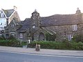 Tintagel Old Post Office.
 -
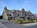 The Old Post Office from the east.


External links
- Tintagel Old Post Office information at the National Trust
- Historic England. "Details from listed building database ({{{num}}})". National Heritage List for England.
Wikimedia Commons has media related to Tintagel Old Post Office.
| Unitary authorities | |
|---|---|
| Major settlements (cities in italics) |
|
| Rivers | |
| Topics | |
This article about a building or structure in Cornwall is a stub. You can help Wikipedia by expanding it. |