
North River Mills, West Virginia: Difference between revisions
Content deleted Content added
mNo edit summary |
mNo edit summary |
||
| Line 57: | Line 57: | ||
|postal_code = 26711 |
|postal_code = 26711 |
||
|area_code = [[Area code 304|304]] |
|area_code = [[Area code 304|304]] |
||
|blank_name |
|blank_name = [[Geographic Names Information System|GNIS]] feature ID |
||
|blank_info = |
|blank_info =1555238<ref name=GNIS /> |
||
|blank1_name = [[Geographic Names Information System|GNIS]] feature ID |
|||
|blank1_info =1555238<ref name=GNIS /> |
|||
|website = |
|website = |
||
|footnotes = |
|footnotes = |
||
Revision as of 20:37, 20 November 2009
North River Mills, West Virginia | |
|---|---|
| Country | United States |
| State | West Virginia |
| County | Hampshire |
| Elevation | 814 ft (248 m) |
| Time zone | UTC-5 (Eastern (EST)) |
| • Summer (DST) | UTC-4 (EDT) |
| ZIP code | 26711 |
| Area code | 304 |
| GNIS feature ID | 1555238[1] |
North River Mills is a historic unincorporated village in Hampshire County in the U.S. state of West Virginia. North River Mills is located between Capon Bridge and Slanesville on Cold Stream Road (County Routes 15 and 45/20) at its intersection with North River Road (County Route 4/2). The village of North River Mills lies along the eastern banks of North River from which it takes its name.
Historic sites
- Audra Croston Home
- Hiett Log House
- Kump House (early 19th Century)
- North River Mills United Methodist Church
-
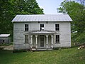 The Audra Croston House along Cold Stream Road (County Route 45/20) in North River Mills
 -
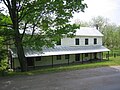 The Hiett Log House along Cold Stream Road (County Route 45/20) in North River Mills


See also
References
External links
![]() Media related to North River Mills, West Virginia at Wikimedia Commons
Media related to North River Mills, West Virginia at Wikimedia Commons
- The Nature Conservancy's Ice Mountain Preserve website
- The North River Mills Society for Antiquarian Arts and the Diffusion of Knowledge
Municipalities and communities of Hampshire County, West Virginia, United States | ||
|---|---|---|
| City |  | |
| Town | ||
| CDPs | ||
| Unincorporated communities |
| |