
Route Napoléon: Difference between revisions
Tom.Reding (talk | contribs) m +{{Authority control}} (1 ID from Wikidata), WP:GenFixes on |
m date formats per MOS:DATEFORMAT by script |
||
| Line 1: | Line 1: | ||
{{Use dmy dates|date= |
{{Use dmy dates|date=February 2022}} |
||
{{unreferenced|date=May 2014}} |
{{unreferenced|date=May 2014}} |
||
[[File:Route-Napoleon02.jpg|thumb|250px|Gilded eagle marker along the Route Napoléon, on the southern approach to [[Gap, Hautes-Alpes]]]] |
[[File:Route-Napoleon02.jpg|thumb|250px|Gilded eagle marker along the Route Napoléon, on the southern approach to [[Gap, Hautes-Alpes]]]] |
||
Revision as of 16:43, 3 February 2022


The Route Napoléon is the route taken by Napoléon in 1815 on his return from Elba. It is now concurrent with sections of routes N85, D1085, D4085, and D6085.
The route begins at Golfe-Juan, where Napoleon disembarked 1 March 1815, beginning the Hundred Days that ended at Waterloo. The road was inaugurated in 1932 and meanders from the French Riviera north-northwest along the foothills of the Alps. It is marked along the way by statues of the French Imperial Eagle.
Route
From south to north:
- Antibes
- Grasse
- Saint-Vallier-de-Thiey
- Castellane
- Digne
- Sisteron
- Gap
- Col Bayard (1,246 m)
- Corps
- La Mure
- Laffrey
- Grenoble
Gallery
-
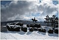 Route Napoleon, Prairie de la Rencontre, Laffrey, France
 -
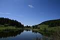 Lake on the Col Bayard


External links
 Media related to Route Napoléon at Wikimedia Commons
| Authority control databases: National |
|---|
This article about road transport in France is a stub. You can help Wikipedia by expanding it. |
This article about the period of the Napoleonic Wars (1803–1815) is a stub. You can help Wikipedia by expanding it. |
This Provence-Alpes-Côte d'Azur geography article is a stub. You can help Wikipedia by expanding it. |