
Rochester, Vermont: Difference between revisions
GreenC bot (talk | contribs) Move 4 urls. Wayback Medic 2.5 |
Ken Gallager (talk | contribs) communities |
||
| (27 intermediate revisions by 17 users not shown) | |||
| Line 1: | Line 1: | ||
{{Short description|Town in Vermont}} |
|||
{{Use mdy dates|date=May 2024}} |
|||
<!-- Infobox begins. Additional parameter fields maybe available at Template:Infobox settlement --> |
<!-- Infobox begins. Additional parameter fields maybe available at Template:Infobox settlement --> |
||
{{Infobox settlement |
{{Infobox settlement |
||
| Line 9: | Line 11: | ||
|image_skyline = Civil War Memorial, The Park, Rochester, Vermont.jpg |
|image_skyline = Civil War Memorial, The Park, Rochester, Vermont.jpg |
||
|imagesize = |
|imagesize = |
||
|image_caption = |
|image_caption = Civil War memorial in The Park in the center of town |
||
|image_flag = |
|image_flag = |
||
|flag_size = |
|flag_size = |
||
| Line 19: | Line 21: | ||
|blank_emblem_size = |
|blank_emblem_size = |
||
|image_map = Windsor County Vermont incorporated and unincorporated areas Rochester highlighted.svg |
|image_map = Windsor County Vermont incorporated and unincorporated areas Rochester highlighted.svg |
||
|mapsize = |
|mapsize = 250px |
||
|map_caption = Location in [[Windsor County, Vermont|Windsor County]] and the state of [[Vermont]]. |
|map_caption = Location in [[Windsor County, Vermont|Windsor County]] and the state of [[Vermont]]. |
||
| |
|pushpin_map = USA |
||
|pushpin_map_caption = Location within the U.S.A. |
|||
|mapsize1 = 195px |
|||
|map_caption1 = Location of Vermont with the U.S.A. |
|||
|subdivision_type = [[List of sovereign states|Country]] |
|subdivision_type = [[List of sovereign states|Country]] |
||
|subdivision_name = United States |
|subdivision_name = United States |
||
| Line 30: | Line 31: | ||
|subdivision_type2 = [[List of counties in Vermont|County]] |
|subdivision_type2 = [[List of counties in Vermont|County]] |
||
|subdivision_name2 = [[Windsor County, Vermont|Windsor]] |
|subdivision_name2 = [[Windsor County, Vermont|Windsor]] |
||
| |
|parts_type = Communities |
||
|parts = {{ubl|[[Rochester (CDP), Vermont|Rochester]]|Emerson|Jerusalem|Talcville|Tupper}} |
|||
|subdivision_name3 = |
|||
|subdivision_type4 = |
|||
|subdivision_name4 = |
|||
|government_footnotes = |
|government_footnotes = |
||
|government_type = |
|government_type = |
||
| Line 40: | Line 39: | ||
|leader_title1 = <!-- for places with, say, both a mayor and a city manager --> |
|leader_title1 = <!-- for places with, say, both a mayor and a city manager --> |
||
|leader_name1 = |
|leader_name1 = |
||
|leader_title2 = |
|||
|leader_name2 = |
|||
|leader_title3 = |
|||
|leader_name3 = |
|||
|leader_title4 = |
|||
|leader_name4 = |
|||
|established_title = Chartered |
|established_title = Chartered |
||
|established_date = |
|established_date = {{start date and age|1781}} |
||
|area_magnitude = |
|area_magnitude = |
||
|unit_pref = |
|unit_pref = Imperial |
||
|area_footnotes = |
|area_footnotes = |
||
|area_total_km2 = 148.6 |
|area_total_km2 = 148.6 |
||
| Line 58: | Line 51: | ||
|area_water_sq_mi = |
|area_water_sq_mi = |
||
|area_water_percent = |
|area_water_percent = |
||
|population_as_of = |
|population_as_of = 2020 |
||
|population_footnotes = |
|population_footnotes = |
||
|population_note = |
|population_note = |
||
|population_total = |
|population_total = 1099 |
||
|population_density_km2 = auto |
|population_density_km2 = auto |
||
|population_density_sq_mi = |
|population_density_sq_mi = |
||
| Line 80: | Line 73: | ||
|area_code = [[Area code 802|802]] |
|area_code = [[Area code 802|802]] |
||
|blank_name = [[Federal Information Processing Standard|FIPS code]] |
|blank_name = [[Federal Information Processing Standard|FIPS code]] |
||
|blank_info = 50-60100<ref name="GR2">{{cite web|url=https://www.census.gov|publisher=[[United States Census Bureau]]| |
|blank_info = 50-60100<ref name="GR2">{{cite web|url=https://www.census.gov|publisher=[[United States Census Bureau]]|access-date=January 31, 2008|title=U.S. Census website}}</ref> |
||
|blank1_name = [[Geographic Names Information System|GNIS]] feature ID |
|blank1_name = [[Geographic Names Information System|GNIS]] feature ID |
||
|blank1_info = 1462188<ref name="GR3">{{cite web|url=http://geonames.usgs.gov| |
|blank1_info = 1462188<ref name="GR3">{{cite web|url=http://geonames.usgs.gov|access-date=January 31, 2008|title=US Board on Geographic Names|publisher=[[United States Geological Survey]]|date=October 25, 2007}}</ref> |
||
|website = {{URL| |
|website = {{URL|rochestervermont.org}} |
||
|footnotes = |
|footnotes = |
||
}} |
}} |
||
<!-- Infobox ends --> |
<!-- Infobox ends --> |
||
'''Rochester''' is a town in [[Windsor County, Vermont|Windsor County]], [[Vermont]], United States. The population was 1,099 at the [[2020 United States Census|2020 census]].<ref name="Census 2010">{{Cite web| url=https://data.census.gov/cedsci/profile?g=0600000US5002760100| title=Census - Geography Profile - Rochester town, Windsor County, Vermont| publisher=[[United States Census Bureau]]| access-date=October 28, 2021}}</ref> The central village is delineated as the [[Rochester (CDP), Vermont|Rochester]] [[census-designated place]]. |
|||
'''Rochester''' is a town in [[Windsor County, Vermont|Windsor County]], [[Vermont]], United States. The population was 1,139 at the [[2010 United States Census|2010 census]].<ref name="Census 2010">{{Cite web| url=https://www.census.gov| title=Profile of General Population and Housing Characteristics: 2010 Demographic Profile Data (DP-1): Rochester town, Windsor County, Vermont| publisher=[[United States Census Bureau]]| accessdate=July 31, 2012}}</ref> The central village is delineated as the [[Rochester (CDP), Vermont|Rochester]] [[census-designated place]]. |
|||
Set on the edge of the [[Green Mountain National Forest]], the town is a picturesque [[tourist destination]]. |
Set on the edge of the [[Green Mountain National Forest]], the town is a picturesque [[tourist destination]]. |
||
==History== |
==History== |
||
Rochester was granted in 1780, chartered in 1781 to Dudley Chase, Asa Whitcomb and 63 others, then organized in 1788. It was first settled in the winter of 1781-1782 by David Currier and his family.<ref name="books.google.com">[https://books.google.com/books?id=OcoMAAAAYAAJ&lpg=PA9&ots=cUndZkVSIF&dq=coolidge%20mansfield%20history%20description%20new%20england%201859&pg=PA885#v=onepage&q=&f=false Austin J. Coolidge & John B. Mansfield, ''A History and Description of New England;'' Boston, Massachusetts 1859]</ref> Rochester's boundaries expanded through annexation of part of [[Pittsfield, Vermont|Pittsfield]] town in 1806, annexation of an additional area from Pittsfield town plus a part of [[Braintree, Vermont|Braintree]] town in 1824, a part of [[Hancock, Vermont|Hancock]] town in 1834, and finally an annexation of part of [[Goshen, Vermont|Goshen]] town in 1847.<ref>[https://www.sec.state.vt.us/media/224860/se-132.pdf Vermont Secretary of State, State Papers of Vermont, Volume 1: Index to the Papers of the Surveyors-General (page 124)]</ref> |
|||
Rochester was granted in 1780, chartered in 1781 to Dudley Chase, Asa Whitcomb and 63 others, then organized in 1788. It was first settled in the winter of 1781–1782 by David Currier and his family.<ref name="books.google.com">[https://books.google.com/books?id=OcoMAAAAYAAJ&dq=coolidge%20mansfield%20history%20description%20new%20england%201859&pg=PA885 Austin J. Coolidge & John B. Mansfield, ''A History and Description of New England;'' Boston, Massachusetts 1859]</ref> Rochester's boundaries expanded through annexation of part of [[Pittsfield, Vermont|Pittsfield]] town in 1806, annexation of an additional area from Pittsfield town plus a part of [[Braintree, Vermont|Braintree]] town in 1824, a part of [[Hancock, Vermont|Hancock]] town in 1834, and finally an annexation of part of [[Goshen, Vermont|Goshen]] town in 1847.<ref>[https://www.sec.state.vt.us/media/224860/se-132.pdf Vermont Secretary of State, State Papers of Vermont, Volume 1: Index to the Papers of the Surveyors-General (page 124)]</ref> |
|||
The surface of the town is mountainous and broken, but the intervales along the [[White River (Vermont)|White River]] provided good [[alluvial plain|farmland]]. There were sites supplying [[water power]] for [[watermill|mills]]. By 1859, when the population was 1,493, industries included one [[gristmill]], several [[sawmill]]s, one tub factory, and a variety of mechanic shops.<ref name="books.google.com"/> The [[White River Railroad (Vermont)|White River Railroad]] from [[Bethel, Vermont|Bethel]] opened to Rochester in 1900, but was abandoned in 1933 during the [[Great Depression]]. |
The surface of the town is mountainous and broken, but the intervales along the [[White River (Vermont)|White River]] provided good [[alluvial plain|farmland]]. There were sites supplying [[water power]] for [[watermill|mills]]. By 1859, when the population was 1,493, industries included one [[gristmill]], several [[sawmill]]s, one tub factory, and a variety of mechanic shops.<ref name="books.google.com"/> The [[White River Railroad (Vermont)|White River Railroad]] from [[Bethel, Vermont|Bethel]] opened to Rochester in 1900, but was abandoned in 1933 during the [[Great Depression]]. |
||
| Line 99: | Line 92: | ||
Rochester was one of thirteen Vermont towns isolated by flooding caused by [[Hurricane Irene]] in 2011.<ref>[https://www.nytimes.com/2011/08/31/us/31floods.html Floodwaters From Storm Isolate 13 Vermont Towns], ''The New York Times''</ref> |
Rochester was one of thirteen Vermont towns isolated by flooding caused by [[Hurricane Irene]] in 2011.<ref>[https://www.nytimes.com/2011/08/31/us/31floods.html Floodwaters From Storm Isolate 13 Vermont Towns], ''The New York Times''</ref> |
||
In 2018, Rochester High School and Middle School closed due to Act 46. The school had been in Rochester since 1886 and the current building had been used since 1974. |
|||
<gallery> |
<gallery> |
||
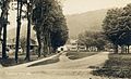
Image:Main Street, Rochester, VT.jpg|Main Street in 1912 |
Image:Main Street, Rochester, VT.jpg|Main Street in 1912 |
||
Image:Pierce Residence, Rochester, VT.jpg|Pierce residence |
Image:Pierce Residence, Rochester, VT.jpg|Pierce residence {{circa|1915}} |
||
Image:View of Rochester, VT.jpg|Street scene |
Image:View of Rochester, VT.jpg|Street scene {{circa|1915}} |
||
Image:PostcardBirdsEyeViewRochesterVTCirca1900to1910.jpg|The village, early 1900s |
Image:PostcardBirdsEyeViewRochesterVTCirca1900to1910.jpg|The village, early 1900s |
||
</gallery> |
</gallery> |
||
==Geography== |
==Geography== |
||
According to the [[United States Census Bureau]], the town has a total area of {{convert|148.6|sqkm|disp=flip}}, of which {{convert|147.8|sqkm|disp=flip}} is land and {{convert|0.8|sqkm|disp=flip}}, or 0.53%, is water.<ref>{{Cite web| url=https://www.census.gov| title=Geographic Identifiers: 2010 Demographic Profile Data (G001): Rochester town, Windsor County, Vermont| publisher=[[United States Census Bureau]]| |
According to the [[United States Census Bureau]], the town has a total area of {{convert|148.6|sqkm|disp=flip}}, of which {{convert|147.8|sqkm|disp=flip}} is land and {{convert|0.8|sqkm|disp=flip}}, or 0.53%, is water.<ref>{{Cite web| url=https://www.census.gov| title=Geographic Identifiers: 2010 Demographic Profile Data (G001): Rochester town, Windsor County, Vermont| publisher=[[United States Census Bureau]]| access-date=July 31, 2012}}</ref> Rochester is drained by the [[White River (Vermont)|White River]]. |
||
The town is crossed by [[Vermont Route 73]] and [[Vermont Route 100]]. |
The town is crossed by [[Vermont Route 73]] and [[Vermont Route 100]]. |
||
===Climate=== |
|||
Rochester has a [[humid continental climate]] ([[Köppen climate classification|Köppen]] ''Dfb''). |
|||
{{Weather box |
|||
| width = auto |
|||
| collapsed = yes |
|||
| single line = yes |
|||
| location = Rochester, Vermont (1991–2020 normals, extremes 1964–2020) |
|||
| Jan record high F = 64 |
|||
| Feb record high F = 70 |
|||
| Mar record high F = 82 |
|||
| Apr record high F = 91 |
|||
| May record high F = 92 |
|||
| Jun record high F = 95 |
|||
| Jul record high F = 95 |
|||
| Aug record high F = 98 |
|||
| Sep record high F = 95 |
|||
| Oct record high F = 84 |
|||
| Nov record high F = 75 |
|||
| Dec record high F = 68 |
|||
| year record high F = |
|||
| Jan high F = 29.2 |
|||
| Feb high F = 32.1 |
|||
| Mar high F = 40.6 |
|||
| Apr high F = 54.1 |
|||
| May high F = 67.3 |
|||
| Jun high F = 75.1 |
|||
| Jul high F = 79.4 |
|||
| Aug high F = 78.3 |
|||
| Sep high F = 71.7 |
|||
| Oct high F = 58.5 |
|||
| Nov high F = 46.4 |
|||
| Dec high F = 34.5 |
|||
| year high F = 55.6 |
|||
| Jan mean F = 18.9 |
|||
| Feb mean F = 20.5 |
|||
| Mar mean F = 29.0 |
|||
| Apr mean F = 41.9 |
|||
| May mean F = 53.9 |
|||
| Jun mean F = 62.5 |
|||
| Jul mean F = 67.2 |
|||
| Aug mean F = 66.0 |
|||
| Sep mean F = 59.1 |
|||
| Oct mean F = 47.1 |
|||
| Nov mean F = 36.6 |
|||
| Dec mean F = 25.5 |
|||
| year mean F = 44.0 |
|||
| Jan low F = 8.7 |
|||
| Feb low F = 8.8 |
|||
| Mar low F = 17.3 |
|||
| Apr low F = 29.7 |
|||
| May low F = 40.5 |
|||
| Jun low F = 49.8 |
|||
| Jul low F = 55.0 |
|||
| Aug low F = 53.8 |
|||
| Sep low F = 46.6 |
|||
| Oct low F = 35.8 |
|||
| Nov low F = 26.8 |
|||
| Dec low F = 16.4 |
|||
| year low F = 32.4 |
|||
| Jan record low F = -32 |
|||
| Feb record low F = -28 |
|||
| Mar record low F = -21 |
|||
| Apr record low F = 1 |
|||
| May record low F = 21 |
|||
| Jun record low F = 30 |
|||
| Jul record low F = 35 |
|||
| Aug record low F = 33 |
|||
| Sep record low F = 23 |
|||
| Oct record low F = 9 |
|||
| Nov record low F = -2 |
|||
| Dec record low F = -30 |
|||
| year record low F = |
|||
| precipitation colour = green |
|||
| Jan precipitation inch = 3.49 |
|||
| Feb precipitation inch = 2.82 |
|||
| Mar precipitation inch = 3.38 |
|||
| Apr precipitation inch = 3.81 |
|||
| May precipitation inch = 3.85 |
|||
| Jun precipitation inch = 5.24 |
|||
| Jul precipitation inch = 5.09 |
|||
| Aug precipitation inch = 4.45 |
|||
| Sep precipitation inch = 3.93 |
|||
| Oct precipitation inch = 4.96 |
|||
| Nov precipitation inch = 3.73 |
|||
| Dec precipitation inch = 4.12 |
|||
| year precipitation inch = 48.87 |
|||
| unit precipitation days = 0.01 in |
|||
| Jan precipitation days = 8.7 |
|||
| Feb precipitation days = 8.1 |
|||
| Mar precipitation days = 8.5 |
|||
| Apr precipitation days = 10.7 |
|||
| May precipitation days = 13.1 |
|||
| Jun precipitation days = 14.3 |
|||
| Jul precipitation days = 12.9 |
|||
| Aug precipitation days = 11.0 |
|||
| Sep precipitation days = 10.0 |
|||
| Oct precipitation days = 12.9 |
|||
| Nov precipitation days = 9.4 |
|||
| Dec precipitation days = 10.5 |
|||
| year precipitation days = 130.1 |
|||
| Jan snow inch = 18.4 |
|||
| Feb snow inch = 17.4 |
|||
| Mar snow inch = 15.5 |
|||
| Apr snow inch = 3.6 |
|||
| May snow inch = 0.0 |
|||
| Jun snow inch = 0.0 |
|||
| Jul snow inch = 0.0 |
|||
| Aug snow inch = 0.0 |
|||
| Sep snow inch = 0.0 |
|||
| Oct snow inch = 0.5 |
|||
| Nov snow inch = 2.8 |
|||
| Dec snow inch = 17.3 |
|||
| year snow inch = 75.5 |
|||
| unit snow days = 0.1 in |
|||
| Jan snow days = 7.0 |
|||
| Feb snow days = 6.5 |
|||
| Mar snow days = 4.9 |
|||
| Apr snow days = 1.2 |
|||
| May snow days = 0.0 |
|||
| Jun snow days = 0.0 |
|||
| Jul snow days = 0.0 |
|||
| Aug snow days = 0.0 |
|||
| Sep snow days = 0.0 |
|||
| Oct snow days = 0.4 |
|||
| Nov snow days = 1.7 |
|||
| Dec snow days = 7.0 |
|||
| year snow days = 28.7 |
|||
| source = [[National Oceanic and Atmospheric Administration|NOAA]]<ref name="NOWData">{{cite web |
|||
|url = https://www.weather.gov/wrh/Climate?wfo=btv |
|||
|title = NOWData - NOAA Online Weather Data |
|||
|publisher = National Oceanic and Atmospheric Administration |
|||
|access-date = December 17, 2023}}</ref><ref name="NCEI">{{cite web |
|||
|url = https://www.ncei.noaa.gov/access/services/data/v1?dataset=normals-monthly-1991-2020&stations=USC00436893&format=pdf&dataTypes=MLY-TMAX-NORMAL,MLY-TMIN-NORMAL,MLY-TAVG-NORMAL,MLY-PRCP-NORMAL,MLY-SNOW-NORMAL |
|||
|title = Summary of Monthly Normals 1991-2020 |
|||
|publisher = National Oceanic and Atmospheric Administration |
|||
|access-date = December 17, 2023}}</ref> |
|||
}} |
|||
==Demographics== |
==Demographics== |
||
| Line 136: | Line 268: | ||
|2000= 1171 |
|2000= 1171 |
||
|2010= 1139 |
|2010= 1139 |
||
|2020= 1099 |
|||
|estyear=2014 |
|||
|estimate=1121 |
|||
|estref=<ref name="USCensusEst2014">{{cite web|url=https://www.census.gov/popest/data/cities/totals/2014/SUB-EST2014.html|title=Annual Estimates of the Resident Population for Incorporated Places: April 1, 2010 to July 1, 2014|accessdate=June 4, 2015|url-status=dead|archiveurl=https://web.archive.org/web/20150523034651/https://www.census.gov/popest/data/cities/totals/2014/SUB-EST2014.html|archivedate=May 23, 2015}}</ref> |
|||
|align-fn=center |
|align-fn=center |
||
|footnote=U.S. Decennial Census<ref>{{cite web|url=https://www.census.gov/programs-surveys/decennial-census.html|title=U.S. Decennial Census|publisher=United States Census Bureau| |
|footnote=U.S. Decennial Census<ref>{{cite web|url=https://www.census.gov/programs-surveys/decennial-census.html|title=U.S. Decennial Census|publisher=United States Census Bureau|access-date=May 16, 2015}}</ref> |
||
}} |
}} |
||
As of the [[census]]<ref name="GR2" /> of 2000, there were 1,171 people, 511 households, and 330 families residing in the town. The [[population density]] was 20.8 people per square mile (8.0/km<sup>2</sup>). There were 768 housing units at an average density of 13.7 per square mile (5.3/km<sup>2</sup>). The racial makeup of the town was 98.46% [[White (U.S. Census)|White]], 0.17% [[African American (U.S. Census)|African American]], 0.17% [[Asian (U.S. Census)|Asian]], and 1.20% from two or more races. [[Hispanic (U.S. Census)|Hispanic]] or [[Latino (U.S. Census)|Latino]] of any race were 1.20% of the population. |
As of the [[census]]<ref name="GR2" /> of 2000, there were 1,171 people, 511 households, and 330 families residing in the town. The [[population density]] was 20.8 people per square mile (8.0/km<sup>2</sup>). There were 768 housing units at an average density of 13.7 per square mile (5.3/km<sup>2</sup>). The racial makeup of the town was 98.46% [[White (U.S. Census)|White]], 0.17% [[African American (U.S. Census)|African American]], 0.17% [[Asian (U.S. Census)|Asian]], and 1.20% from two or more races. [[Hispanic (U.S. Census)|Hispanic]] or [[Latino (U.S. Census)|Latino]] of any race were 1.20% of the population. |
||
[[File:Public library, Rochester, Vermont.jpg|thumb|left|Rochester Public Library]] |
[[File:Public library, Rochester, Vermont.jpg|thumb|left|Rochester Public Library]] |
||
There were 511 households out of which 28.2% had children under the age of 18 living with them, 52.4% were couples living together and joined in either [[marriage]] or [[Civil Union|civil union]], 8.8% had a female householder with no husband present, and 35.4% were non-families. 28.6% of all households were made up of individuals and 11.2% had someone living alone who was 65 years of age or older. The average household size was 2.26 and the average family size was 2.76. |
There were 511 households, out of which 28.2% had children under the age of 18 living with them, 52.4% were couples living together and joined in either [[marriage]] or [[Civil Union|civil union]], 8.8% had a female householder with no husband present, and 35.4% were non-families. 28.6% of all households were made up of individuals, and 11.2% had someone living alone who was 65 years of age or older. The average household size was 2.26 and the average family size was 2.76. |
||
In the town, the population was spread out with 22.1% under the age of 18, 5.0% from 18 to 24, 26.3% from 25 to 44, 28.8% from 45 to 64, and 17.8% who were 65 years of age or older. The median age was 43 years. For every 100 females, there were 93.2 males. For every 100 females age 18 and over, there were 96.6 males. |
In the town, the population was spread out, with 22.1% under the age of 18, 5.0% from 18 to 24, 26.3% from 25 to 44, 28.8% from 45 to 64, and 17.8% who were 65 years of age or older. The median age was 43 years. For every 100 females, there were 93.2 males. For every 100 females age 18 and over, there were 96.6 males. |
||
The median income for a household in the town was $35,820, and the median income for a family was $41,131. Males had a median income of $30,395 versus $21,964 for females. The [[per capita income]] for the town was $19,986. About 4.2% of families and 6.0% of the population were below the [[poverty line]], including 8.5% of those under age 18 and 1.0% of those age 65 or over. |
The median income for a household in the town was $35,820, and the median income for a family was $41,131. Males had a median income of $30,395 versus $21,964 for females. The [[per capita income]] for the town was $19,986. About 4.2% of families and 6.0% of the population were below the [[poverty line]], including 8.5% of those under age 18 and 1.0% of those age 65 or over. |
||
| Line 163: | Line 293: | ||
{{div col}} |
{{div col}} |
||
*[[Barbara Fiske Calhoun]], World War II cartoonist, artist and co-founder of [[Quarry Hill Creative Center]] |
*[[Barbara Fiske Calhoun]], World War II cartoonist, artist and co-founder of [[Quarry Hill Creative Center]] |
||
* [[William Wildman Campbell]], US congressman from [[Ohio]] |
* [[William Wildman Campbell]], US congressman from [[Ohio]] |
||
* [[Irving Fiske]], playwright and co-founder of [[Quarry Hill Creative Center]] in Rochester |
* [[Irving Fiske]], playwright and co-founder of [[Quarry Hill Creative Center]] in Rochester |
||
* [[Robert H. Gardner]], Academy Award nominated filmmaker, resides in Rochester<ref>{{Cite web|url=https://www.ourherald.com/articles/documentary-film-director-had-a-good-feeling-about-vt/|title = Documentary Film Director 'Had a Good Feeling' About Vt. - the White River Valley Herald|date = May 7, 2015}}</ref> |
|||
* [[Jeremiah Ingalls]], early American composer |
* [[Jeremiah Ingalls]], early American composer |
||
* [[William B. Martin]], Iowa Secretary of State |
* [[William B. Martin]], Iowa Secretary of State |
||
| Line 180: | Line 311: | ||
==External links== |
==External links== |
||
{{Commons category}} |
|||
* [http://www.rochestervermont.org Town of Rochester official website] |
* [http://www.rochestervermont.org Town of Rochester official website] |
||
* [http://www.rochesterlibrary.net Rochester Public Library] |
* [http://www.rochesterlibrary.net Rochester Public Library] |
||
| Line 188: | Line 320: | ||
{{Windsor County, Vermont}} |
{{Windsor County, Vermont}} |
||
{{authority control}} |
{{authority control}} |
||
[[Category:Rochester, Vermont| ]] |
|||
[[Category:Towns in Vermont]] |
[[Category:Towns in Vermont]] |
||
[[Category:Rochester, Vermont| ]] |
|||
[[Category:Towns in Windsor County, Vermont]] |
[[Category:Towns in Windsor County, Vermont]] |
||
[[Category:Populated places established in 1780]] |
[[Category:Populated places established in 1780]] |
||
Latest revision as of 13:58, 4 September 2024
Rochester, Vermont | |
|---|---|
Town | |
 Civil War memorial in The Park in the center of town | |
| Motto: The heart of the Green Mountains | |
 Location in Windsor County and the state of Vermont. | |
 Rochester, Vermont Location within the U.S.A. | |
| Coordinates: 43°52′34″N 72°48′44″W / 43.87611°N 72.81222°W | |
| Country | United States |
| State | Vermont |
| County | Windsor |
| Chartered | 1781 |
| Communities |
|
| Area | |
| • Total | 57.4 sq mi (148.6 km2) |
| • Land | 57.1 sq mi (147.8 km2) |
| • Water | 0.3 sq mi (0.8 km2) |
| Elevation | 878 ft (620 m) |
| Population (2020) | |
| • Total | 1,099 |
| • Density | 19/sq mi (7.4/km2) |
| Time zone | UTC-5 (EST) |
| • Summer (DST) | UTC-4 (EDT) |
| ZIP code | 05767 |
| Area code | 802 |
| FIPS code | 50-60100[1] |
| GNIS feature ID | 1462188[2] |
| Website | rochestervermont |
Rochester is a town in Windsor County, Vermont, United States. The population was 1,099 at the 2020 census.[3] The central village is delineated as the Rochester census-designated place.
Set on the edge of the Green Mountain National Forest, the town is a picturesque tourist destination.
History
[edit]Rochester was granted in 1780, chartered in 1781 to Dudley Chase, Asa Whitcomb and 63 others, then organized in 1788. It was first settled in the winter of 1781–1782 by David Currier and his family.[4] Rochester's boundaries expanded through annexation of part of Pittsfield town in 1806, annexation of an additional area from Pittsfield town plus a part of Braintree town in 1824, a part of Hancock town in 1834, and finally an annexation of part of Goshen town in 1847.[5]
The surface of the town is mountainous and broken, but the intervales along the White River provided good farmland. There were sites supplying water power for mills. By 1859, when the population was 1,493, industries included one gristmill, several sawmills, one tub factory, and a variety of mechanic shops.[4] The White River Railroad from Bethel opened to Rochester in 1900, but was abandoned in 1933 during the Great Depression.
Rochester was one of thirteen Vermont towns isolated by flooding caused by Hurricane Irene in 2011.[6]
In 2018, Rochester High School and Middle School closed due to Act 46. The school had been in Rochester since 1886 and the current building had been used since 1974.
-
 Main Street in 1912
 -
 Pierce residence c. 1915
 -
 Street scene c. 1915
 -
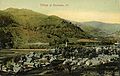 The village, early 1900s


Geography
[edit]According to the United States Census Bureau, the town has a total area of 57.4 square miles (148.6 km2), of which 57.1 square miles (147.8 km2) is land and 0.31 square miles (0.8 km2), or 0.53%, is water.[7] Rochester is drained by the White River.
The town is crossed by Vermont Route 73 and Vermont Route 100.
Climate
[edit]Rochester has a humid continental climate (Köppen Dfb).
| Climate data for Rochester, Vermont (1991–2020 normals, extremes 1964–2020) | |||||||||||||
|---|---|---|---|---|---|---|---|---|---|---|---|---|---|
| Month | Jan | Feb | Mar | Apr | May | Jun | Jul | Aug | Sep | Oct | Nov | Dec | Year |
| Record high °F (°C) | 64 (18) |
70 (21) |
82 (28) |
91 (33) |
92 (33) |
95 (35) |
95 (35) |
98 (37) |
95 (35) |
84 (29) |
75 (24) |
68 (20) |
98 (37) |
| Mean daily maximum °F (°C) | 29.2 (−1.6) |
32.1 (0.1) |
40.6 (4.8) |
54.1 (12.3) |
67.3 (19.6) |
75.1 (23.9) |
79.4 (26.3) |
78.3 (25.7) |
71.7 (22.1) |
58.5 (14.7) |
46.4 (8.0) |
34.5 (1.4) |
55.6 (13.1) |
| Daily mean °F (°C) | 18.9 (−7.3) |
20.5 (−6.4) |
29.0 (−1.7) |
41.9 (5.5) |
53.9 (12.2) |
62.5 (16.9) |
67.2 (19.6) |
66.0 (18.9) |
59.1 (15.1) |
47.1 (8.4) |
36.6 (2.6) |
25.5 (−3.6) |
44.0 (6.7) |
| Mean daily minimum °F (°C) | 8.7 (−12.9) |
8.8 (−12.9) |
17.3 (−8.2) |
29.7 (−1.3) |
40.5 (4.7) |
49.8 (9.9) |
55.0 (12.8) |
53.8 (12.1) |
46.6 (8.1) |
35.8 (2.1) |
26.8 (−2.9) |
16.4 (−8.7) |
32.4 (0.2) |
| Record low °F (°C) | −32 (−36) |
−28 (−33) |
−21 (−29) |
1 (−17) |
21 (−6) |
30 (−1) |
35 (2) |
33 (1) |
23 (−5) |
9 (−13) |
−2 (−19) |
−30 (−34) |
−32 (−36) |
| Average precipitation inches (mm) | 3.49 (89) |
2.82 (72) |
3.38 (86) |
3.81 (97) |
3.85 (98) |
5.24 (133) |
5.09 (129) |
4.45 (113) |
3.93 (100) |
4.96 (126) |
3.73 (95) |
4.12 (105) |
48.87 (1,241) |
| Average snowfall inches (cm) | 18.4 (47) |
17.4 (44) |
15.5 (39) |
3.6 (9.1) |
0.0 (0.0) |
0.0 (0.0) |
0.0 (0.0) |
0.0 (0.0) |
0.0 (0.0) |
0.5 (1.3) |
2.8 (7.1) |
17.3 (44) |
75.5 (192) |
| Average precipitation days (≥ 0.01 in) | 8.7 | 8.1 | 8.5 | 10.7 | 13.1 | 14.3 | 12.9 | 11.0 | 10.0 | 12.9 | 9.4 | 10.5 | 130.1 |
| Average snowy days (≥ 0.1 in) | 7.0 | 6.5 | 4.9 | 1.2 | 0.0 | 0.0 | 0.0 | 0.0 | 0.0 | 0.4 | 1.7 | 7.0 | 28.7 |
| Source: NOAA[8][9] | |||||||||||||
Demographics
[edit]| Census | Pop. | Note | %± |
|---|---|---|---|
| 1790 | 215 | — | |
| 1800 | 524 | 143.7% | |
| 1810 | 911 | 73.9% | |
| 1820 | 1,148 | 26.0% | |
| 1830 | 1,392 | 21.3% | |
| 1840 | 1,396 | 0.3% | |
| 1850 | 1,493 | 6.9% | |
| 1860 | 1,507 | 0.9% | |
| 1870 | 1,444 | −4.2% | |
| 1880 | 1,362 | −5.7% | |
| 1890 | 1,257 | −7.7% | |
| 1900 | 1,250 | −0.6% | |
| 1910 | 1,317 | 5.4% | |
| 1920 | 1,397 | 6.1% | |
| 1930 | 1,285 | −8.0% | |
| 1940 | 1,129 | −12.1% | |
| 1950 | 937 | −17.0% | |
| 1960 | 879 | −6.2% | |
| 1970 | 884 | 0.6% | |
| 1980 | 1,054 | 19.2% | |
| 1990 | 1,181 | 12.0% | |
| 2000 | 1,171 | −0.8% | |
| 2010 | 1,139 | −2.7% | |
| 2020 | 1,099 | −3.5% | |
| U.S. Decennial Census[10] | |||
As of the census[1] of 2000, there were 1,171 people, 511 households, and 330 families residing in the town. The population density was 20.8 people per square mile (8.0/km2). There were 768 housing units at an average density of 13.7 per square mile (5.3/km2). The racial makeup of the town was 98.46% White, 0.17% African American, 0.17% Asian, and 1.20% from two or more races. Hispanic or Latino of any race were 1.20% of the population.

There were 511 households, out of which 28.2% had children under the age of 18 living with them, 52.4% were couples living together and joined in either marriage or civil union, 8.8% had a female householder with no husband present, and 35.4% were non-families. 28.6% of all households were made up of individuals, and 11.2% had someone living alone who was 65 years of age or older. The average household size was 2.26 and the average family size was 2.76.
In the town, the population was spread out, with 22.1% under the age of 18, 5.0% from 18 to 24, 26.3% from 25 to 44, 28.8% from 45 to 64, and 17.8% who were 65 years of age or older. The median age was 43 years. For every 100 females, there were 93.2 males. For every 100 females age 18 and over, there were 96.6 males.
The median income for a household in the town was $35,820, and the median income for a family was $41,131. Males had a median income of $30,395 versus $21,964 for females. The per capita income for the town was $19,986. About 4.2% of families and 6.0% of the population were below the poverty line, including 8.5% of those under age 18 and 1.0% of those age 65 or over.
Site of interest
[edit]Notable people
[edit]- Barbara Fiske Calhoun, World War II cartoonist, artist and co-founder of Quarry Hill Creative Center
- William Wildman Campbell, US congressman from Ohio
- Irving Fiske, playwright and co-founder of Quarry Hill Creative Center in Rochester
- Robert H. Gardner, Academy Award nominated filmmaker, resides in Rochester[11]
- Jeremiah Ingalls, early American composer
- William B. Martin, Iowa Secretary of State
- Edna Chaffee Noble, elocutionist
- James Whitcomb, US senator and the eighth governor of Indiana
Climate
[edit]This climatic region is typified by large seasonal temperature differences, with warm to hot (and often humid) summers and cold (sometimes severely cold) winters. According to the Köppen Climate Classification system, Rochester has a humid continental climate, abbreviated "Dfb" on climate maps.[12]
References
[edit]- ^ a b "U.S. Census website". United States Census Bureau. Retrieved January 31, 2008.
- ^ "US Board on Geographic Names". United States Geological Survey. October 25, 2007. Retrieved January 31, 2008.
- ^ "Census - Geography Profile - Rochester town, Windsor County, Vermont". United States Census Bureau. Retrieved October 28, 2021.
- ^ a b Austin J. Coolidge & John B. Mansfield, A History and Description of New England; Boston, Massachusetts 1859
- ^ Vermont Secretary of State, State Papers of Vermont, Volume 1: Index to the Papers of the Surveyors-General (page 124)
- ^ Floodwaters From Storm Isolate 13 Vermont Towns, The New York Times
- ^ "Geographic Identifiers: 2010 Demographic Profile Data (G001): Rochester town, Windsor County, Vermont". United States Census Bureau. Retrieved July 31, 2012.
- ^ "NOWData - NOAA Online Weather Data". National Oceanic and Atmospheric Administration. Retrieved December 17, 2023.
- ^ "Summary of Monthly Normals 1991-2020". National Oceanic and Atmospheric Administration. Retrieved December 17, 2023.
- ^ "U.S. Decennial Census". United States Census Bureau. Retrieved May 16, 2015.
- ^ "Documentary Film Director 'Had a Good Feeling' About Vt. - the White River Valley Herald". May 7, 2015.
- ^ Climate Summary for Rochester, Vermont
External links
[edit]- Town of Rochester official website
- Rochester Public Library
- Rochester Historical Society
- Rochester School District
- Rochester at Virtual Vermont
- Historic Pierce Hall
Municipalities and communities of Windsor County, Vermont, United States | ||
|---|---|---|
| Towns | ||
| Villages | ||
| CDPs | ||
| Other communities | ||
| International | |
|---|---|
| National | |