
Geological hazard: Difference between revisions
Carcharoth (talk | contribs) change category |
|||
| (117 intermediate revisions by 80 users not shown) | |||
| Line 1: | Line 1: | ||
{{short description|Geological state that may lead to widespread damage or risk}} |
|||
<!-- [[Image:Laconchita1995landslide.jpg|thumb|right|200px|Huge landslide at [[La Conchita]], 1995]] --> |
|||
{{More citations needed|date=December 2009}} |
|||
[[Image:Laconchita1995landslide.jpg|thumb|right|200px|Huge landslide at [[La Conchita]], 1995]] |
|||
A '''geologic hazard''' or '''geohazard''' is an adverse [[geology|geologic]] condition capable of causing widespread damage or loss of property and life.<ref>[http://www.geohazards.no International Centre for Geohazards] {{webarchive|url=https://web.archive.org/web/20080302114513/http://www.geohazards.no/ |date=March 2, 2008 }}</ref> These [[hazards]] are geological and environmental conditions and involve long-term or short-term geological processes. Geohazards can be relatively small features, but they can also attain huge dimensions (e.g., submarine or surface [[landslide]]) and affect local and regional socio-economics to a large extent (e.g., [[tsunami]]s). |
|||
Sometimes the hazard is instigated by the careless location of developments or construction in which the conditions were not taken into account. Human activities, such as drilling through overpressured zones, could result in significant risk, and as such mitigation and prevention are paramount, through improved understanding of geohazards, their preconditions, causes and implications. In other cases, particularly in montane regions, natural processes can cause catalytic events of a complex nature, such as an avalanche hitting a lake and causing a debris flow, with consequences potentially hundreds of miles away, or creating a lahar by volcanism. |
|||
'''Marine geohazards''' in particular constitute a fast-growing sector of research as they involve seismic, tectonic, volcanic processes now occurring at higher frequency, and often resulting in coastal sub-marine avalanches or devastating '''tsunamis''' in some of the most densely populated areas of the world <ref>{{cite journal |last1=de Lange |first1=G. |last2=Sakellariou |first2=D. |last3=Briand |first3=F. |date=2011 |title=Marine Geohazards in the Mediterranean: an overview |journal=CIESM Workshop Monographs |volume=42 |pages=7–26}}[https://www.researchgate.net/publication/272164711]</ref><ref>{{cite journal | last1 = Cardenas | first1 = I.C.| title = Marine geohazards exposed: Uncertainties involved | journal = [[Marine Georesources and Geotechnology]] | year = 2022| volume = 41| issue = 6| pages = 589–619| doi=10.1080/1064119X.2022.2078252| s2cid = 249161443|display-authors=etal| doi-access = free| hdl = 11250/3058338| hdl-access = free}}</ref> |
|||
Such impacts on vulnerable coastal populations, coastal infrastructures, offshore exploration platforms, obviously call for a higher level of preparedness and mitigation.<ref>{{cite journal | last1 = Nadim | year = 2006 | title = Challenges to geo-scientists in risk assessment for sub-marine slides | journal = Norwegian Journal of Geology | volume = 86 | issue = 3| pages = 351–362 }}</ref><ref>{{cite journal | last1 = Solheim | first1 = A.| title = 2005. Ormen Lange – An integrated study for the safe development of a deep-water gas field within the Storegga Slide complex, NE Atlantic continental margin; executive summary | journal = [[Marine and Petroleum Geology]] | volume = 22 | issue = 1–2| pages = 1–9 | doi=10.1016/j.marpetgeo.2004.10.001|display-authors=etal}}</ref> |
|||
==Speed of development== |
|||
===Sudden phenomena=== |
|||
Sudden phenomena include: |
|||
* [[avalanche]]s (snow or rock) and its runout |
|||
* [[earthquake]]s and earthquake-triggered phenomena such as [[tsunami]]s |
|||
* [[forest fire]]s (espec. in Mediterranean areas) leading to [[deforestation]] |
|||
* [[geomagnetic storms]]<ref>[http://www.nationalatlas.gov/articles/geology/a_geohazards.html ''Geologic Hazards'' NationalAtlas] {{webarchive|url=https://web.archive.org/web/20100430002306/http://www.nationalatlas.gov/articles/geology/a_geohazards.html |date=2010-04-30 }}</ref> |
|||
* [[cambering (geology)|gulls]] (chasms) associated with cambering of valley sides |
|||
* [[ice jam]]s (Eisstoß) on rivers or [[glacial lake outburst flood]]s below a [[glacier]] |
|||
* [[landslide]] (displacement of earth materials on a slope or hillside) |
|||
* [[mudflow]]s (avalanche-like muddy flow of soft/wet soil and sediment materials, narrow landslides) |
|||
* [[pyroclastic flows]] |
|||
* [[rockfall]]s, [[rock slide]]s, ([[rock avalanche]]) and [[debris flow]]s |
|||
* torrents ([[flash flood]]s, rapid floods or heavy current creeks with irregular course) |
|||
*[[liquefaction]] (settlement of the ground in areas underlain by loose saturated sand/silt during an earthquake event) |
|||
* [[volcano|volcanic eruptions]], [[lahar]]s and [[ash fall]]s. |
|||
===Slow phenomena=== |
|||
Gradual or slow phenomena include: |
|||
* [[alluvial fan]]s (e.g. at the exit of [[canyon]]s or [[side valley]]s) |
|||
* [[caldera]] development (volcanoes) |
|||
* [[geyser]] [[deposition (geology)|deposit]]s |
|||
* ground settlement due to consolidation of compressible soils or due to collapseable soils (''see also [[Soil compaction|compaction]]) |
|||
* ground [[subsidence]], [[sag (geology)|sag]]s and [[sinkhole]]s |
|||
* [[sand dune]] migration |
|||
* shoreline and stream [[erosion]] |
|||
* [[thermal spring]]s |
|||
==Evaluation and mitigation== |
|||
Geologic hazards are typically evaluated by [[engineering geologists]] who are educated and trained in interpretation of landforms and earth process, earth-structure interaction, and in geologic hazard mitigation. The engineering geologist provides recommendations and designs to mitigate for geologic hazards. Trained hazard mitigation planners also assist local communities to identify strategies for mitigating the effects of such hazards and developing plans to implement these measures. Mitigation can include a variety of measures: |
|||
* Geologic hazards may be avoided by relocation. Publicly available databases, via searchable platforms,<ref>{{Cite web |last=Toussaint |first=Kristin |date=2021-09-29 |title=Are environmental hazards threatening your home? This website will show you |url=https://www.fastcompany.com/90681175/are-there-environmental-hazards-threatening-your-home-this-website-will-show-you |access-date=2022-06-13 |website=Fast Company |language=en-US}}</ref> can help people evaluate hazards in locations of interest. |
|||
* Mapping geohazards using conventional or remote sensing techniques<ref>{{Cite journal |last1=Tomás |first1=Roberto |last2=Pagán |first2=José Ignacio |last3=Navarro |first3=José A. |last4=Cano |first4=Miguel |last5=Pastor |first5=José Luis |last6=Riquelme |first6=Adrián |last7=Cuevas-González |first7=María |last8=Crosetto |first8=Michele |last9=Barra |first9=Anna |last10=Monserrat |first10=Oriol |last11=Lopez-Sanchez |first11=Juan M. |last12=Ramón |first12=Alfredo |last13=Ivorra |first13=Salvador |last14=Del Soldato |first14=Matteo |last15=Solari |first15=Lorenzo |date=January 2019 |title=Semi-Automatic Identification and Pre-Screening of Geological–Geotechnical Deformational Processes Using Persistent Scatterer Interferometry Datasets |journal=Remote Sensing |language=en |volume=11 |issue=14 |pages=1675 |doi=10.3390/rs11141675 |doi-access=free |bibcode=2019RemS...11.1675T |issn=2072-4292|hdl=2158/1162779 |hdl-access=free }}</ref> can also help identify suitable areas for urban development. |
|||
* The [[slope stability|stability of sloping earth]] can be improved by the construction of [[retaining wall]]s, which may use techniques such as [[slurry wall]]s, [[shear pin]]s, [[tieback (geotechnical)|tiebacks]], [[soil nailing|soil nail]]s or [[soil anchor]]s. Larger projects may use [[gabion]]s and other forms of [[earthworks (engineering)|earth buttress]]. |
|||
* Shorelines and streams are protected against [[Tidal scour|scour]] and erosion using [[revetment]]s and [[riprap]]. |
|||
* The [[soil]] or rock itself may be improved by means such as dynamic compaction, injection of [[grout]] or concrete, and [[mechanically stabilized earth]]. |
|||
* Additional mitigation methods include [[deep foundation]]s, [[tunnel]]s, surface and [[drainage|subdrain]] systems, and other measures. |
|||
*Planning measures include regulations prohibiting development near hazard-prone areas and adoption of [[building codes]]. |
|||
== In paleohistory == |
|||
Eleven distinct [[flood basalt]] episodes occurred in the past 250 million years, resulting in [[large volcanic province]]s, creating [[lava plateau]]s and [[mountain range]]s on Earth.<ref>{{cite journal|url=https://www.science.org/doi/10.1126/science.241.4866.663|author1=[[Michael R. Rampino]] |author2=Richard B. Stothers |title=Flood Basalt Volcanism During the Past 250 Million Years|doi=10.1126/science.241.4866.663|year=1988|journal=Science|volume=241|issue=4866|pages=663–668|pmid=17839077|bibcode = 1988Sci...241..663R |s2cid=33327812}}</ref> Large igneous provinces have been connected to five [[mass extinction]] events. The timing of six out of eleven known provinces coincide with periods of [[global warming]] and marine [[Anoxic event|anoxia]]/dysoxia. Thus, suggesting that volcanic CO<sub>2</sub> emissions can force an important effect on the [[climate system]].<ref>{{cite journal|author=P.B. Wignall|title=Large igneous provinces and mass extinctions|doi=10.1016/S0012-8252(00)00037-4|year=2001|journal=Earth-Science Reviews|volume=53|issue=1–2|pages=1–33|bibcode=2001ESRv...53....1W}}</ref> |
|||
==Known hazards== |
|||
{{See also|Lists of earthquakes|List of largest volcanic eruptions}} |
|||
* [[2004 Indian Ocean earthquake and tsunami]] |
|||
* [[2008 Sichuan earthquake]] |
|||
* [[2011 Tōhoku earthquake and tsunami]] |
|||
* [[The Barrier]] (located in [[Garibaldi Provincial Park]]) |
|||
* [[Usoi Dam]] a natural landslide dam |
|||
<!--and others, to be added--> |
|||
A '''Geologic Hazard''' is one of several types of adverse [[geology| geologic]] conditions capable of causing damage or loss of property and life. These [[hazard]]s can consist of |
|||
<gallery> |
<gallery> |
||
Image:Laconchita1995landslide.jpg|Huge landslide at [[La Conchita]], Cal, 1995 |
|||
Image:Frozen_Danube_Reichsbrücke.JPG|Eisstoß Feb.2006 Vienna, Austria ([[Donauinsel]]) |
Image:Frozen_Danube_Reichsbrücke.JPG|Eisstoß Feb.2006 Vienna, Austria ([[Donauinsel]]) |
||
Image:Glacier.swiss.500pix.jpg|Glacier just above [[Grindelwald]], Switzerland |
Image:Glacier.swiss.500pix.jpg|Glacier just above [[Grindelwald]], Switzerland |
||
Image:Liquefaction at Niigata.JPG|[[Soil liquefaction]] during the [[1964 Niigata earthquake]] |
|||
</gallery> |
</gallery> |
||
==See also== |
|||
=== Sudden or slow phenomena (alfabetic order) === |
|||
{{See also|Natural hazard|Volcanic hazard}} |
|||
* [[avalanche]]s (snow, or air & snow) and its runout |
|||
* |
*[[Earthquake engineering]] |
||
* [[Physical impacts of climate change]] |
|||
* [[fault rupture]] (displacement of the [[terrain]] or ground along a [[geological fault]]), recent [[active fault|(active)]] fault (exhibiting actual movement or seismic activity) |
|||
* [[forest fire]]s (espec. in [[mediterranean]] areas) |
|||
* [[ice jam]]s or ice [[impact|impact]] (Eisstoß) on rivers or below a [[glacier]] |
|||
<!-- [[Image:Frozen_Danube_Reichsbrücke.JPG|thumb|Eisstoß at the [[Donauinsel]] in Vienna, [[Austria]] during a very cold winter (Feb.2006). A frozen [[Danube]] is a phenomenon experienced only once or twice a lifetime]] --> |
|||
<!-- ([[:Image:Frozen_Danube_Reichsbrücke.JPG|Details]]) |
|||
[[Image:Glacier.swiss.500pix.jpg|thumb|Glacier above [[Grindelwald]], Switzerland --> |
|||
* [[landslide]] (lateral displacement of earth materials on a slope or hillside) |
|||
* [[mudflow]]s (avalanche-like muddy flow of soft/wet soil and sediment materials, narrow landslides) |
|||
* [[pyroclastic flows]] (can also be slow, ''see below'') |
|||
* [[rock fall]]s (tumbling down of rock masses) |
|||
* [[rock slide]]s (rock avalanche) and [[debris flow]]s |
|||
* [[torrent]]s (rapid floods or heavy current creeks with irregular course) |
|||
* [[volcano|volcanic eruptions]], [[lahar]]s and [[ash fall]]s. |
|||
==References== |
|||
'''Rather gradual or slow phenomena are e.g.:''' |
|||
{{reflist}} |
|||
* [[alluvial cone]]s (e.g. at the exit of [[canyon]]s or [[side valley]]s) |
|||
* [[caldera]] development (volcanoes) |
|||
==External links== |
|||
[[Image:Norris_geyser_basin.jpg|thumb|right|Norris geyser at [[ National Park|Yellowstone NP]], Sept.2003]] |
|||
*{{Commons category-inline|Geological hazards}} |
|||
* [[geyser]] [[deposit]]s (see image) |
|||
*[https://web.archive.org/web/20080302114513/http://www.geohazards.no/ International Centre for Geohazards (ICG)] |
|||
* ground settlement due to consolidation of compressible soils or due to [[collapse]]able soils (''see also [[compaction]]) |
|||
*[https://beinsure.com/global-natural-catastrophe-hazard-review/ Global Natural Catastrophe and Hazard Review] |
|||
* [[land degradation]] |
|||
* ground [[subsidence]], [[sag]]s, other geomorphologic [[displacement]]s |
|||
* land [[uplift]], heave (?), [[post-glacial rebound]] |
|||
* [[liquefaction]] (settlement of the ground in areas underlain by loose saturated sand/silt during an earthquake event), [[seismically induced settlement]] |
|||
* [[sea cave]]s, [[sinkhole]]s, [[void]]s (?), [[erosion]] |
|||
* [[thermal spring]]s, burial or inundation |
|||
* wandering [[sand dunes]] |
|||
* or other conditions due to [[geologic]], [[seismic]] or [[tectonic]] forces and movements. Sometime the hazard is instigated by man on by the careless location of developments or construction in which the conditions were not taken into account. |
|||
{{Natural disasters}} |
|||
=== Geologic Hazard Evaluation === |
|||
{{Authority control}} |
|||
Geologic hazards are evaluated by an [[engineering geologist]] educated, trained and experienced in [[engineering geology]] for their recogition, investigation and analysis. Often in conjunction with a [[geotechnical engineer]], the engineering geologist is qualified to formulate recommendations for the mitigation of the hazards. Mitigation can include avoidance of the hazards or relocation; construction of [[slope stabilization]] measures ([[earth buttress]], [[retaining wall]]s, [[diversion wall]]s, [[shear pin]]s, [[tieback]]s, [[soil nail]]s or [[soil anchor]]s, [[revetment]]s, injection of [[grout]] or concrete, deep foundations, [[tunnel]]s, [[subdrain]]s), and other measures. |
|||
{{DEFAULTSORT:Geologic hazards}} |
|||
=== See also: === |
|||
[[Category:Geological hazards| ]] |
|||
* [[Geology]], [[Geodynamics]], [[Soil sciences]] |
|||
[[Category:Physical geography]] |
|||
* [[geologic fault]], [[escarpment]], [[Interpraevent]] 2002-2004 |
|||
[[Category:Geomorphology]] |
|||
* [[fault scarp]], [[valley shoulder]], [[landslide]] |
|||
[[Category: |
[[Category:Disasters]] |
||
Latest revision as of 15:46, 31 August 2024
This article needs additional citations for verification. (December 2009) |

A geologic hazard or geohazard is an adverse geologic condition capable of causing widespread damage or loss of property and life.[1] These hazards are geological and environmental conditions and involve long-term or short-term geological processes. Geohazards can be relatively small features, but they can also attain huge dimensions (e.g., submarine or surface landslide) and affect local and regional socio-economics to a large extent (e.g., tsunamis).
Sometimes the hazard is instigated by the careless location of developments or construction in which the conditions were not taken into account. Human activities, such as drilling through overpressured zones, could result in significant risk, and as such mitigation and prevention are paramount, through improved understanding of geohazards, their preconditions, causes and implications. In other cases, particularly in montane regions, natural processes can cause catalytic events of a complex nature, such as an avalanche hitting a lake and causing a debris flow, with consequences potentially hundreds of miles away, or creating a lahar by volcanism.
Marine geohazards in particular constitute a fast-growing sector of research as they involve seismic, tectonic, volcanic processes now occurring at higher frequency, and often resulting in coastal sub-marine avalanches or devastating tsunamis in some of the most densely populated areas of the world [2][3]
Such impacts on vulnerable coastal populations, coastal infrastructures, offshore exploration platforms, obviously call for a higher level of preparedness and mitigation.[4][5]
Speed of development
[edit]Sudden phenomena
[edit]Sudden phenomena include:
- avalanches (snow or rock) and its runout
- earthquakes and earthquake-triggered phenomena such as tsunamis
- forest fires (espec. in Mediterranean areas) leading to deforestation
- geomagnetic storms[6]
- gulls (chasms) associated with cambering of valley sides
- ice jams (Eisstoß) on rivers or glacial lake outburst floods below a glacier
- landslide (displacement of earth materials on a slope or hillside)
- mudflows (avalanche-like muddy flow of soft/wet soil and sediment materials, narrow landslides)
- pyroclastic flows
- rockfalls, rock slides, (rock avalanche) and debris flows
- torrents (flash floods, rapid floods or heavy current creeks with irregular course)
- liquefaction (settlement of the ground in areas underlain by loose saturated sand/silt during an earthquake event)
- volcanic eruptions, lahars and ash falls.
Slow phenomena
[edit]Gradual or slow phenomena include:
- alluvial fans (e.g. at the exit of canyons or side valleys)
- caldera development (volcanoes)
- geyser deposits
- ground settlement due to consolidation of compressible soils or due to collapseable soils (see also compaction)
- ground subsidence, sags and sinkholes
- sand dune migration
- shoreline and stream erosion
- thermal springs
Evaluation and mitigation
[edit]Geologic hazards are typically evaluated by engineering geologists who are educated and trained in interpretation of landforms and earth process, earth-structure interaction, and in geologic hazard mitigation. The engineering geologist provides recommendations and designs to mitigate for geologic hazards. Trained hazard mitigation planners also assist local communities to identify strategies for mitigating the effects of such hazards and developing plans to implement these measures. Mitigation can include a variety of measures:
- Geologic hazards may be avoided by relocation. Publicly available databases, via searchable platforms,[7] can help people evaluate hazards in locations of interest.
- Mapping geohazards using conventional or remote sensing techniques[8] can also help identify suitable areas for urban development.
- The stability of sloping earth can be improved by the construction of retaining walls, which may use techniques such as slurry walls, shear pins, tiebacks, soil nails or soil anchors. Larger projects may use gabions and other forms of earth buttress.
- Shorelines and streams are protected against scour and erosion using revetments and riprap.
- The soil or rock itself may be improved by means such as dynamic compaction, injection of grout or concrete, and mechanically stabilized earth.
- Additional mitigation methods include deep foundations, tunnels, surface and subdrain systems, and other measures.
- Planning measures include regulations prohibiting development near hazard-prone areas and adoption of building codes.
In paleohistory
[edit]Eleven distinct flood basalt episodes occurred in the past 250 million years, resulting in large volcanic provinces, creating lava plateaus and mountain ranges on Earth.[9] Large igneous provinces have been connected to five mass extinction events. The timing of six out of eleven known provinces coincide with periods of global warming and marine anoxia/dysoxia. Thus, suggesting that volcanic CO2 emissions can force an important effect on the climate system.[10]
Known hazards
[edit]- 2004 Indian Ocean earthquake and tsunami
- 2008 Sichuan earthquake
- 2011 Tōhoku earthquake and tsunami
- The Barrier (located in Garibaldi Provincial Park)
- Usoi Dam a natural landslide dam
-
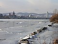 Eisstoß Feb.2006 Vienna, Austria (Donauinsel)
 -
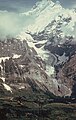 Glacier just above Grindelwald, Switzerland
 -
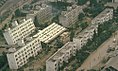 Soil liquefaction during the 1964 Niigata earthquake


See also
[edit]References
[edit]- ^ International Centre for Geohazards Archived March 2, 2008, at the Wayback Machine
- ^ de Lange, G.; Sakellariou, D.; Briand, F. (2011). "Marine Geohazards in the Mediterranean: an overview". CIESM Workshop Monographs. 42: 7–26.[1]
- ^ Cardenas, I.C.; et al. (2022). "Marine geohazards exposed: Uncertainties involved". Marine Georesources and Geotechnology. 41 (6): 589–619. doi:10.1080/1064119X.2022.2078252. hdl:11250/3058338. S2CID 249161443.
- ^ Nadim (2006). "Challenges to geo-scientists in risk assessment for sub-marine slides". Norwegian Journal of Geology. 86 (3): 351–362.
- ^ Solheim, A.; et al. "2005. Ormen Lange – An integrated study for the safe development of a deep-water gas field within the Storegga Slide complex, NE Atlantic continental margin; executive summary". Marine and Petroleum Geology. 22 (1–2): 1–9. doi:10.1016/j.marpetgeo.2004.10.001.
- ^ Geologic Hazards NationalAtlas Archived 2010-04-30 at the Wayback Machine
- ^ Toussaint, Kristin (2021-09-29). "Are environmental hazards threatening your home? This website will show you". Fast Company. Retrieved 2022-06-13.
- ^ Tomás, Roberto; Pagán, José Ignacio; Navarro, José A.; Cano, Miguel; Pastor, José Luis; Riquelme, Adrián; Cuevas-González, María; Crosetto, Michele; Barra, Anna; Monserrat, Oriol; Lopez-Sanchez, Juan M.; Ramón, Alfredo; Ivorra, Salvador; Del Soldato, Matteo; Solari, Lorenzo (January 2019). "Semi-Automatic Identification and Pre-Screening of Geological–Geotechnical Deformational Processes Using Persistent Scatterer Interferometry Datasets". Remote Sensing. 11 (14): 1675. Bibcode:2019RemS...11.1675T. doi:10.3390/rs11141675. hdl:2158/1162779. ISSN 2072-4292.
- ^ Michael R. Rampino; Richard B. Stothers (1988). "Flood Basalt Volcanism During the Past 250 Million Years". Science. 241 (4866): 663–668. Bibcode:1988Sci...241..663R. doi:10.1126/science.241.4866.663. PMID 17839077. S2CID 33327812.
- ^ P.B. Wignall (2001). "Large igneous provinces and mass extinctions". Earth-Science Reviews. 53 (1–2): 1–33. Bibcode:2001ESRv...53....1W. doi:10.1016/S0012-8252(00)00037-4.
External links
[edit] Media related to Geological hazards at Wikimedia Commons
- International Centre for Geohazards (ICG)
- Global Natural Catastrophe and Hazard Review
| Authority control databases: National |
|---|