
Isla de Mona: Difference between revisions
Citation bot (talk | contribs) Removed proxy/dead URL that duplicated identifier. | Use this bot. Report bugs. | Suggested by SemperIocundus | #UCB_webform 425/2500 |
m Corrected wiki link Tags: Visual edit Mobile edit Mobile web edit |
||
| (20 intermediate revisions by 15 users not shown) | |||
| Line 2: | Line 2: | ||
{{Redirect|Mona Island|text=Mona is also an ancient or poetic name for the island of [[Anglesey]] or the [[Isle of Man]]}} |
{{Redirect|Mona Island|text=Mona is also an ancient or poetic name for the island of [[Anglesey]] or the [[Isle of Man]]}} |
||
{{Infobox islands |
{{Infobox islands |
||
| name = |
| name = Mona Island |
||
| image_name = |
| image_name = ISS006-E-37860 - View of Puerto Rico.jpg |
||
| image_caption = Satellite Image |
| image_caption = Satellite Image |
||
| map = Puerto Rico |
| map = Puerto Rico |
||
| Line 10: | Line 10: | ||
| native_name_link = |
| native_name_link = |
||
| nickname = Amona |
| nickname = Amona |
||
| location = |
| location =[[Caribbean]] |
||
| coordinates = {{coord|18|5|12|N|67|53|22|W|display=inline,title}} |
| coordinates = {{coord|18|5|12|N|67|53|22|W|display=inline,title}} |
||
| archipelago = |
| archipelago =[[Geography of Puerto Rico |Puerto Rico]] |
||
| total_islands = |
| total_islands = |
||
| major_islands = |
| major_islands = |
||
| Line 40: | Line 40: | ||
|designation3_date=1975 |
|designation3_date=1975 |
||
}} |
}} |
||
|pushpin_map=Puerto Rico#Lesser Antilles#Caribbean# North America#World|pushpin_relief=1}} |
|||
| ⚫ | |||
'''Mona''' ({{lang-es|Isla de Mona}}) is the third-largest island of the [[Puerto Rico|Puerto Rican |
'''Mona Island''' ({{lang-es|Isla de Mona}}) is the third-largest island of the [[Geography of Puerto Rico|Puerto Rican archipelago]], after the main island of [[Puerto Rico]] and [[Vieques]]. It is the largest of three islands in the [[Mona Passage]], the strait between [[Hispaniola]] and Puerto Rico, with the others being [[Monito Island]] and [[Desecheo Island]]. It measures about 7 miles by 4 miles (11 km by 7 km), and lies {{convert|41|mi|km|abbr=on}} west of Puerto Rico, of which it is administratively a part. It is one of two islands that make up the [[Isla de Mona e Islote Monito]] barrio in the municipality of [[Mayagüez, Puerto Rico|Mayagüez]]. |
||
[[File:STS007-4-137 - View of Puerto Rico.jpg|thumb| |
[[File:STS007-4-137 - View of Puerto Rico.jpg|thumb|Satellite image of Mona Island between the Dominican Republic (left) and the Puerto Rico mainland (right)]] |
||
The island is managed under the [[Mona and Monito Islands Nature Reserve]] (''Reserva Natural Islas de Mona y Monito'').<ref name="drna">{{cite web |url=http://drna.pr.gov/historico/oficinas/oficina-de-prensa-y-comunicaciones/hojas-informativas/Hoja%20informativa%20sobre%20la%20Reserva%20Natural%20Isla%20de%20Mona.doc?set_language=es-pr&cl=es-pr |title=Reserva Natural Isla de Mona |access-date=9 June 2016 |language=es |trans-title=Mona Island Nature Reserve |archive-url=https://web.archive.org/web/20160630044345/http://drna.pr.gov/historico/oficinas/oficina-de-prensa-y-comunicaciones/hojas-informativas/Hoja%20informativa%20sobre%20la%20Reserva%20Natural%20Isla%20de%20Mona.doc?set_language=es-pr&cl=es-pr |archive-date=30 June 2016 |url-status=dead }}</ref> There are no |
The island is managed under the [[Mona and Monito Islands Nature Reserve]] (''Reserva Natural Islas de Mona y Monito'').<ref name="drna">{{cite web |url=http://drna.pr.gov/historico/oficinas/oficina-de-prensa-y-comunicaciones/hojas-informativas/Hoja%20informativa%20sobre%20la%20Reserva%20Natural%20Isla%20de%20Mona.doc?set_language=es-pr&cl=es-pr |title=Reserva Natural Isla de Mona |access-date=9 June 2016 |language=es |trans-title=Mona Island Nature Reserve |archive-url=https://web.archive.org/web/20160630044345/http://drna.pr.gov/historico/oficinas/oficina-de-prensa-y-comunicaciones/hojas-informativas/Hoja%20informativa%20sobre%20la%20Reserva%20Natural%20Isla%20de%20Mona.doc?set_language=es-pr&cl=es-pr |archive-date=30 June 2016 |url-status=dead }}</ref> There are no permanent inhabitants; only rangers and biologists from the [[Puerto Rico Department of Natural and Environmental Resources]] reside on the island, to manage visitors and take part in research projects. The island, along with Monito, form part of the '''Mona and Monito Islands''' [[National Natural Landmark]]<ref>{{Cite web|title=National Natural Landmarks - National Natural Landmarks (U.S. National Park Service)|url=https://www.nps.gov/subjects/nnlandmarks/site.htm|access-date=2021-11-28|website=www.nps.gov|language=en}}</ref> which recognizes and preserves the islands' ecosystem as an outstanding example of diversity and natural history.<ref>{{Cite web|title=National Natural Landmarks (U.S. National Park Service)|url=https://www.nps.gov/subjects/nnlandmarks/index.htm|access-date=2021-11-28|website=www.nps.gov|language=en}}</ref> The island is home to a number of endemic species such as the [[Mona ground iguana]] and it is an important seabird area.<ref>{{Cite web|title=Mona Island, Puerto Rico|url=https://www.islandconservation.org/mona-island-puerto-rico/|access-date=2021-11-28|website=Island Conservation|language=en-US}}</ref> |
||
==History== |
==History== |
||
[[File:Mona Taíno cave art no.2.jpg|thumb|[[Taíno]] cave art in caves of Mona island]] |
|||
===Pre-Columbian history=== |
===Pre-Columbian history=== |
||
| Line 79: | Line 80: | ||
During [[Prohibition in the United States|Prohibition]] the island had a history of [[Alcohol smuggling|smuggling]], with its geographic location making it a prime location for [[rum runners]] to smuggle rum, [[Bourbon whiskey|bourbon]], and other liquor. In 1923, a stash of liquor, drugs, and perfumes, reportedly from the French islands of [[Martinique]] and [[Collectivity of Saint Martin|Saint Martin]] and worth US$75,000, was found in a cave by customs officials. |
During [[Prohibition in the United States|Prohibition]] the island had a history of [[Alcohol smuggling|smuggling]], with its geographic location making it a prime location for [[rum runners]] to smuggle rum, [[Bourbon whiskey|bourbon]], and other liquor. In 1923, a stash of liquor, drugs, and perfumes, reportedly from the French islands of [[Martinique]] and [[Collectivity of Saint Martin|Saint Martin]] and worth US$75,000, was found in a cave by customs officials. |
||
In 1942, at the height of [[World War II]], a [[German submarine U-156 (1941)|German U-156 submarine]] fired 30 |
In 1942, at the height of [[World War II]], a [[German submarine U-156 (1941)|German U-156 submarine]] fired 30 shells from its deck gun at the southern coast of the island. The crew of the [[Nazi Germany|Nazi]] vessel suspected that Camp Cofresí, a camp that the [[Civilian Conservation Corps]] were using as the base of a reforestation effort, could be an unmarked military facility. There were no significant losses, but the incident was one of the few military strikes of the war in the [[Caribbean]], which was also the focus of a [[Battle of the Caribbean|German/Italian campaign]] against [[Allies of World War II|Allied]] resource shipping. Prior to this, the Nazi [[U-boat]] had sunk nineteen ships in the region including one named ''Del Plata'' in Puerto Rican waters. On June 4, 1942, the [[oil tanker]] [[MV C.O. Stillman|MV ''C.O. Stillman'']] was sunk by the German submarine {{GS|U-68|1940|2}} {{convert|41|nmi|km}} southwest of Isla de Mona.<ref>{{cite book|year=1946 |title=Ships of the Esso Fleet in World War II |chapter=Sank Stern First |publisher=[[Esso|Standard Oil Company of New Jersey]] |page=262 |url=https://www.armed-guard.com/cstill.html |access-date=1 October 2022 |via=Project Liberty Ship}}</ref> From 1945 to 1955 Mona Island was leased to the [[U.S. Air Force]] as a military exercise area. |
||
Since 1941 the island has also been used for camping and hunting goats and wild boar. In 1960 a small ranger post was established to monitor the island, operated by the [[Puerto Rico Department of Natural and Environmental Resources]]. |
Since 1941 the island has also been used for camping and hunting goats and wild boar. In 1960 a small ranger post was established to monitor the island, operated by the [[Puerto Rico Department of Natural and Environmental Resources]]. |
||
| Line 89: | Line 90: | ||
On February 15, 1985, the passenger-cargo ferry {{MV|A Regina||6}} ran aground on a reef on the southeastern side of Mona Island. While there were no deaths nor serious injuries, 143 passengers and 72 crew members landed on Mona Island to await rescue. The wreck of the ship was removed from the reef in 1990. |
On February 15, 1985, the passenger-cargo ferry {{MV|A Regina||6}} ran aground on a reef on the southeastern side of Mona Island. While there were no deaths nor serious injuries, 143 passengers and 72 crew members landed on Mona Island to await rescue. The wreck of the ship was removed from the reef in 1990. |
||
In 1993, the island, inscribed as ''Isla de la Mona'', was listed as a historic district on the National Register of Historic Places.<ref name=nris/> The historic district consists of eight contributing buildings (including the lighthouse), nine prehistoric and historic archaeological sites (including several [[Ball court/plaza sites of Puerto Rico and the U.S. Virgin Islands|ceremonial ball courts]] or ''[[Batey (game)|bateyes]]''), two guano industrial ruins, a roadway and a cistern.<ref>{{Cite web |last=United States Department of the Interior |first=National Park Service |date=October 29, 1993 |title=NATIONAL REGISTER OF HISTORIC PLACES REGISTRATION FORM for Amona |url=https://oech.pr.gov/Propiedades%20en%20el%20Registro%20Nacional/Isla%20de%20Mona/Isla%20de%20Mona.pdf |website=oech.pr.gov}}</ref> |
|||
In 1993, the island, inscribed as ''Isla de la Mona'', was listed on the National Register.<ref name=nris/> |
|||
==Geography== |
==Geography== |
||
[[File: |
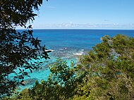
[[File:Isla de Mona, Puerto Rico.jpg|thumb|Mona is a mainly flat plateau surrounded by sea cliffs.]] |
||
Mona has an area of about {{convert|22|sqmi|km2|abbr=on}} and lies {{convert|41|mi|km|abbr=on}} west of the main island of Puerto Rico, {{convert|38|mi|km|abbr=on}} east of the [[Dominican Republic]], and {{convert|30|mi|km|abbr=on}} southwest of [[Desecheo Island]], another island in the [[Mona Passage]]. |
Mona has an area of about {{convert|22|sqmi|km2|abbr=on}} and lies {{convert|41|mi|km|abbr=on}} west of the main island of Puerto Rico, {{convert|38|mi|km|abbr=on}} east of the [[Dominican Republic]], and {{convert|30|mi|km|abbr=on}} southwest of [[Desecheo Island]], another island in the [[Mona Passage]]. |
||
Mona has been designated an ecological reserve by the Puerto Rican government and is not permanently inhabited. The US [[census]] of 2000 |
Mona has been designated an ecological reserve by the Puerto Rican government and is not permanently inhabited. The US [[census]] of 2000 reported six housing units, but a population of zero.<ref>{{Cite web |url=http://factfinder.census.gov/servlet/GCTTable?ds_name=DEC_2000_SF1_U&_box_head_nbr=GCT-PH1&format=CO-2&geo_id=05000US72097 |title=US Census (2000) |access-date=2006-06-06 |archive-url=https://archive.today/20200214061627/http://factfinder.census.gov/servlet/GCTTable?ds_name=DEC_2000_SF1_U&_box_head_nbr=GCT-PH1&format=CO-2&geo_id=05000US72097 |archive-date=2020-02-14 |url-status=dead }}</ref> The island is a [[Barrios of Puerto Rico|barrio]] of the [[Municipalities of Puerto Rico|municipality]] of [[Mayagüez, Puerto Rico|Mayagüez]], together with [[Monito Island]] 3.1 mi (5 km) northwest (''[[Isla de Mona e Islote Monito, Mayagüez, Puerto Rico|Isla de Mona e Islote Monito]] barrio''). This is the largest ward of [[Mayagüez, Puerto Rico|Mayagüez]] by area, and the only one without permanent population. The total land area of both islands in the barrio is about 21.98 square miles (56.93 km<sup>2</sup>) (Mona Island 21.924 square miles [56.783 km<sup>2</sup>] and nearby Monito Island 0.057 square miles [0.147 km<sup>2</sup>]), and it comprises 28.3 percent of the total land area of the municipality of Mayagüez. [[Desecheo Island]], 30 mi (49 km) to the northeast, is part of Sabanetas barrio. |
||
Mona is a mainly flat plateau surrounded by sea cliffs. It is composed of [[Dolomite (rock)|dolomite]] and [[limestone]] with many [[caves]] found throughout. With an arid [[climate]] and untouched by human development, many [[endemic (ecology)|endemic]] species inhabit the island, such as the [[Mona ground iguana]] (''Cyclura cornuta stejnegeri''). Its topography, ecology, and modern history are similar to that of [[Navassa Island]], a small limestone island located in the [[Jamaica Channel]], between [[Jamaica]] and [[Haiti]]. |
Mona is a mainly flat plateau surrounded by sea cliffs. It is composed of [[Dolomite (rock)|dolomite]] and [[limestone]] with many [[caves]] found throughout. With an arid [[climate]] and untouched by human development, many [[endemic (ecology)|endemic]] species inhabit the island, such as the [[Mona ground iguana]] (''Cyclura cornuta stejnegeri''). Its topography, ecology, and modern history are similar to that of [[Navassa Island]], a small limestone island located in the [[Jamaica Channel]], between [[Jamaica]] and [[Haiti]]. |
||
=== Caves === |
=== Caves === |
||
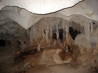
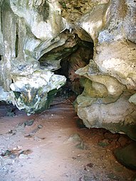
[[File:Looking out from Cueva del Diamante, Isla de Mona, Puerto Rico.jpg|thumb|Looking out from {{lang|es|Cueva del Diamante}}]] |
|||
There are around 200 caves, including {{lang|es|El gato}}, {{lang|es|La esperanza}}, {{lang|es|La negra}}, |
There are around 200 caves, including {{lang|es|El gato}}, {{lang|es|La esperanza}}, {{lang|es|La negra}}, |
||
{{lang|es|Los ingleses}}, {{lang|es|El rifle}}, {{lang|es|El toro}}, {{lang|es|Del norte}}, {{lang|es|Ataúd}}, {{lang|es|Nuevos Lirios}} and {{lang|es|Gallinas}}<ref name="drna" /> on Isla de Mona, with thousands of |
{{lang|es|Los ingleses}}, {{lang|es|El rifle}}, {{lang|es|El toro}}, {{lang|es|Del norte}}, {{lang|es|Ataúd}}, {{lang|es|Nuevos Lirios}} and {{lang|es|Gallinas}}<ref name="drna" /> on Isla de Mona, with thousands of examples of native art, marks and later on, graffiti.<ref>{{Cite web|url=http://news.nationalgeographic.com/2016/07/cave-art-caribbean-mona-island-first-contact-archaeology|title=Cave Walls Record Early Encounters Between Old World and New|date=2016-07-19|access-date=2016-07-20|archive-date=2016-07-21|archive-url=https://web.archive.org/web/20160721124534/http://news.nationalgeographic.com/2016/07/cave-art-caribbean-mona-island-first-contact-archaeology/|url-status=dead}}</ref><ref>{{Cite journal|last1=Cooper|first1=Jago|last2=Samson|first2=Alice V.M.|last3=Nieves|first3=Miguel A.|last4=Lace|first4=Michael J.|last5=Caamaño-Dones |first5=Josué|last6=Cartwright|first6=Caroline|last7=Kambesis|first7=Patricia N. |last8=Frese|first8=Laura del Olmo|date=2016-08-01|title='The Mona Chronicle': the archaeology of early religious encounter in the New World|journal=Antiquity|volume=90|issue=352|pages=1054–1071|doi=10.15184/aqy.2016.103|issn=1745-1744|doi-access=free|hdl=2381/37561|hdl-access=free}}</ref><ref name="RG">{{cite web |title=Karst development and speleogenesis, Isla de Mona, Puerto Rico |url=https://www.researchgate.net/figure/Map-of-Cueva-del-Diamante-Isla-de-Mona-Puerto-Rico-Cave-map-symbols-used-generally_fig4_252375651 |website=Research gate |access-date=24 September 2021}}</ref> |
||
===Climate=== |
===Climate=== |
||
The Isla de Mona has a [[tropical savanna climate]] (''Aw'' according to the [[Köppen climate classification]]), with a dry season and wet season and the temperature being warm year-round. The |
The Isla de Mona has a [[tropical savanna climate]] (''Aw'' according to the [[Köppen climate classification]]), with a dry season and wet season and the temperature being warm year-round. The average annual mean is {{convert|26.6|C|F|abbr=on}}, an average annual high is {{convert|31.7|C|F|abbr=on}} and an average annual low is {{convert|21.5|C|F|abbr=on}}. August, the warmest month, has a mean of {{convert|28.3|C|F|abbr=on}} and an average high of {{convert|33.8|C|F|abbr=on}}, while the coolest month, January, has a mean of {{convert|24.8|C|F|abbr=on}} and an average low of {{convert|20.3|C|F|abbr=on}}, although February has a lower average low at {{convert|20.0|C|F|abbr=on}}. |
||
On 2 July 1996, the Isla de Mona recorded a temperature of {{convert|40.0|C|F|abbr=on}}, which is the highest temperature to have ever been recorded in Puerto Rico.<ref name=NWSpuertorico>{{cite web |archive-url=https://web.archive.org/web/20170119141404/http://www.weather.gov/sju/climo_extremes |archive-date=19 January 2017|url=http://www.weather.gov/sju/climo_extremes |title=All Time Extremes for PR and VI |publisher=National Weather Service |access-date=19 January 2017}}</ref> |
On 2 July 1996, the Isla de Mona recorded a temperature of {{convert|40.0|C|F|abbr=on}}, which is the highest temperature to have ever been recorded in Puerto Rico.<ref name=NWSpuertorico>{{cite web |archive-url=https://web.archive.org/web/20170119141404/http://www.weather.gov/sju/climo_extremes |archive-date=19 January 2017|url=http://www.weather.gov/sju/climo_extremes |title=All Time Extremes for PR and VI |publisher=National Weather Service |access-date=19 January 2017}}</ref> |
||
Isla de Mona receives {{convert|986|mm}} of precipitation annually over 126.5 precipitation days. Due to [[tropical cyclone]]s, autumn is the wettest season, while winter is the driest. The wettest month is May, which receives {{convert|125|mm}} of precipitation on average. October has 12.7 precipitation days on average, which is the highest of any month. January is the driest month, receiving {{convert|41|mm}}, while April has the least precipitation days (8.3). |
Isla de Mona receives {{convert|986|mm}} of precipitation annually over 126.5 precipitation days. Due to [[tropical cyclone]]s, autumn is the wettest season, while winter is the driest. The wettest month is May, which receives {{convert|125|mm}} of precipitation on average. October has 12.7 precipitation days on average, which is the highest of any month. January is the driest month, receiving {{convert|41|mm}}, while April has the least precipitation days (8.3). |
||
{{Weather box|width=auto |
{{Weather box|width=auto |
||
|location = Mona Island, Puerto Rico |
|location = Mona Island, Puerto Rico (1991–2020 normals, extremes 1980–2010) |
||
|single line = Y |
|single line = Y |
||
| |
|Jan record high F = 96 |
||
| |
|Feb record high F = 96 |
||
| |
|Mar record high F = 97 |
||
| |
|Apr record high F = 99 |
||
| |
|May record high F = 98 |
||
| |
|Jun record high F = 103 |
||
| |
|Jul record high F = 104 |
||
| |
|Aug record high F = 105 |
||
| |
|Sep record high F = 102 |
||
| |
|Oct record high F = 97 |
||
| |
|Nov record high F = 98 |
||
| |
|Dec record high F = 96 |
||
|year record high F = 105 |
|||
|Jan avg record high F = 88.3 |
|||
|Feb avg record high F = 88.3 |
|||
|Mar avg record high F = 90.1 |
|||
|Apr avg record high F = 93.0 |
|||
|May avg record high F = 93.4 |
|||
|Jun avg record high F = 94.6 |
|||
|Jul avg record high F = 94.9 |
|||
|Aug avg record high F = 95.7 |
|||
|Sep avg record high F = 94.8 |
|||
|Oct avg record high F = 93.6 |
|||
|Nov avg record high F = 92.4 |
|||
|Dec avg record high F = 89.4 |
|||
|year avg record high F = 96.4 |
|||
|Jan high F = 84.8 |
|||
|Feb high F = 85.7 |
|||
|Mar high F = 85.9 |
|||
|Apr high F = 88.5 |
|||
|May high F = 90.2 |
|||
|Jun high F = 92.1 |
|||
|Jul high F = 92.3 |
|||
|Aug high F = 92.8 |
|||
|Sep high F = 91.9 |
|||
|Oct high F = 91.0 |
|||
|Nov high F = 87.6 |
|||
|Dec high F = 86.1 |
|||
|year high F = 89.1 |
|year high F = 89.1 |
||
|Jan mean F = 76.6 |
|Jan mean F = 76.6 |
||
| Line 139: | Line 167: | ||
|Dec mean F = 77.5 |
|Dec mean F = 77.5 |
||
|year mean F = 79.9 |
|year mean F = 79.9 |
||
| |
|Jan low F = 68.5 |
||
| |
|Feb low F = 68.0 |
||
| |
|Mar low F = 68.7 |
||
| |
|Apr low F = 69.2 |
||
| |
|May low F = 71.1 |
||
| |
|Jun low F = 72.8 |
||
| |
|Jul low F = 72.6 |
||
| |
|Aug low F = 73.3 |
||
| |
|Sep low F = 72.4 |
||
| |
|Oct low F = 71.9 |
||
| |
|Nov low F = 71.5 |
||
| |
|Dec low F = 68.9 |
||
|year low F = 70.7 |
|year low F = 70.7 |
||
|Jan record |
|Jan avg record low F = 64.6 |
||
|Feb record |
|Feb avg record low F = 64.8 |
||
|Mar record |
|Mar avg record low F = 65.2 |
||
|Apr record |
|Apr avg record low F = 65.3 |
||
|May record |
|May avg record low F = 67.1 |
||
|Jun record |
|Jun avg record low F = 69.4 |
||
|Jul record |
|Jul avg record low F = 68.2 |
||
|Aug record |
|Aug avg record low F = 69.4 |
||
|Sep record |
|Sep avg record low F = 69.1 |
||
|Oct record |
|Oct avg record low F = 69.6 |
||
|Nov record |
|Nov avg record low F = 67.1 |
||
|Dec record |
|Dec avg record low F = 66.3 |
||
|year record |
|year avg record low F = 61.5 |
||
|Jan record low F = |
|Jan record low F = 57 |
||
|Feb record low F = |
|Feb record low F = 58 |
||
|Mar record low F = |
|Mar record low F = 58 |
||
|Apr record low F = |
|Apr record low F = 61 |
||
|May record low F = |
|May record low F = 57 |
||
|Jun record low F = |
|Jun record low F = 61 |
||
|Jul record low F = |
|Jul record low F = 57 |
||
|Aug record low F = |
|Aug record low F = 60 |
||
|Sep record low F = |
|Sep record low F = 61 |
||
|Oct record low F = |
|Oct record low F = 61 |
||
|Nov record low F = |
|Nov record low F = 59 |
||
|Dec record low F = |
|Dec record low F = 60 |
||
|year record low F = |
|year record low F = 57 |
||
|precipitation colour = green |
|precipitation colour = green |
||
| |
|Jan precipitation inch = 1.61 |
||
| |
|Feb precipitation inch = 1.64 |
||
| |
|Mar precipitation inch = 2.17 |
||
| |
|Apr precipitation inch = 2.43 |
||
| |
|May precipitation inch = 4.92 |
||
| |
|Jun precipitation inch = 2.50 |
||
| |
|Jul precipitation inch = 2.30 |
||
| |
|Aug precipitation inch = 4.22 |
||
| |
|Sep precipitation inch = 4.74 |
||
| |
|Oct precipitation inch = 4.49 |
||
| |
|Nov precipitation inch = 3.82 |
||
| |
|Dec precipitation inch = 3.99 |
||
|year precipitation inch = 38.83 |
|year precipitation inch = 38.83 |
||
| |
|unit precipitation days = 0.01 in |
||
| |
|Jan precipitation days = 10.6 |
||
| |
|Feb precipitation days = 8.3 |
||
| |
|Mar precipitation days = 8.8 |
||
| |
|Apr precipitation days = 8.3 |
||
| |
|May precipitation days = 11.6 |
||
| |
|Jun precipitation days = 9.3 |
||
| |
|Jul precipitation days = 11.8 |
||
| |
|Aug precipitation days = 11.2 |
||
| |
|Sep precipitation days = 10.9 |
||
| |
|Oct precipitation days = 12.7 |
||
| |
|Nov precipitation days = 12.5 |
||
| |
|Dec precipitation days = 10.5 |
||
| |
|year precipitation days = 126.5 |
||
|Jan snow inch = |
|||
|Feb snow inch = |
|||
|Mar snow inch = |
|||
|Apr snow inch = |
|||
|May snow inch = |
|||
|Jun snow inch = |
|||
|Jul snow inch = |
|||
|Aug snow inch = |
|||
|Sep snow inch = |
|||
|Oct snow inch = |
|||
|Nov snow inch = |
|||
|Dec snow inch = |
|||
|year snow inch = |
|||
|unit snow days = 0.1 in |
|||
|Jan snow days = |
|||
|Feb snow days = |
|||
|Mar snow days = |
|||
|Apr snow days = |
|||
|May snow days = |
|||
|Jun snow days = |
|||
|Jul snow days = |
|||
|Aug snow days = |
|||
|Sep snow days = |
|||
|Oct snow days = |
|||
|Nov snow days = |
|||
|Dec snow days = |
|||
|year snow days = |
|||
|source 1 = NOAA<ref>{{cite web |
|source 1 = NOAA<ref>{{cite web |
||
| |
|url = https://www.ncei.noaa.gov/access/services/data/v1?dataset=normals-monthly-1991-2020&startDate=0001-01-01&endDate=9996-12-31&stations=RQC00666258&format=pdf |
||
| |
|title = Summary of Monthly Normals 1991-2020 |
||
| |
|publisher = [[National Oceanic and Atmospheric Administration]] |
||
| |
|accessdate = July 13, 2021 |
||
| |
|archive-date = 2021-07-13 |
||
| |
|archive-url = https://web.archive.org/web/20210713043059/https://www.ncei.noaa.gov/access/services/data/v1?dataset=normals-monthly-1991-2020&startDate=0001-01-01&endDate=9996-12-31&stations=RQC00666258&format=pdf |
||
| |
|url-status = live |
||
}}</ref> |
}}</ref> |
||
|source 2 = XMACIS2 (mean maxima/minima 1991–2020)<ref name = XMACIS2> |
|||
{{cite web |
|||
|url = https://xmacis.rcc-acis.org/ |
|||
|publisher = National Oceanic and Atmospheric Administration |
|||
|title = xmACIS2 |
|||
|access-date = August 28, 2023 |
|||
| ⚫ | |||
</ref>}} |
|||
===Land cover=== |
===Land cover=== |
||
Four types of land cover can be identified:<ref>[http://www.gobierno.pr/DRNA/ReservasNaturales/Islas/IslaMona/Isla_MonaV.htm Departamento de Recursos Naturales y Ambientales website] {{Webarchive|url=https://web.archive.org/web/20041226013826/http://www.gobierno.pr/DRNA/ReservasNaturales/Islas/IslaMona/Isla_MonaV.htm |date=2004-12-26 }} (Puerto Rican Department of Natural and Environmental Resources; in Spanish)</ref> |
Four types of land cover can be identified:<ref>[http://www.gobierno.pr/DRNA/ReservasNaturales/Islas/IslaMona/Isla_MonaV.htm Departamento de Recursos Naturales y Ambientales website] {{Webarchive|url=https://web.archive.org/web/20041226013826/http://www.gobierno.pr/DRNA/ReservasNaturales/Islas/IslaMona/Isla_MonaV.htm |date=2004-12-26 }} (Puerto Rican Department of Natural and Environmental Resources; in Spanish)</ref> |
||
* Cactus (4.35 square miles) (11.27 km |
* Cactus (4.35 square miles) (11.27 km<sup>2</sup>) |
||
* Highland forest (15.55 square miles) (40.28 km |
* Highland forest (15.55 square miles) (40.28 km<sup>2</sup>) |
||
* Central Depression forest (0.57 square miles) (1.47 km |
* Central Depression forest (0.57 square miles) (1.47 km<sup>2</sup>) |
||
* Coastal forest (1.46 square miles) (3.77 km |
* Coastal forest (1.46 square miles) (3.77 km<sup>2</sup>) |
||
===Beaches=== |
===Beaches=== |
||
| Line 258: | Line 267: | ||
|width=190 |
|width=190 |
||
|height=200 |
|height=200 |
||
|lines=2 |
|||
|File:Nesting hawksbill turtle Mona Island no.2.jpg|Critically endangered [[hawksbill turtle]] |
|File:Nesting hawksbill turtle Mona Island no.2.jpg|Critically endangered [[hawksbill turtle]] |
||
|File:Nesting hawksbill turtle Mona Island no.1.jpg|Nesting hawksbill |
|File:Nesting hawksbill turtle Mona Island no.1.jpg|Nesting hawksbill |
||
| Line 295: | Line 303: | ||
==Mona Island today== |
==Mona Island today== |
||
[[File:Mona Boa coiled with tongue extended.jpg|thumb|[[Mona Island boa]]]] |
|||
[[File:Iguana sitting down looking to the left.jpg|thumb|[[Mona ground iguana]], endemic to the island]] |
|||
The island presently serves as a retreat for Puerto Ricans and nature enthusiasts from all around the world, and has also become a popular destination for Puerto Rican [[Scouting in Puerto Rico|Boy]] and [[Girl Scouts of the USA|Girl Scouts]]. Due to the islands' unique topography, ecology and location, [[Isla de Mona e Islote Monito, Mayagüez, Puerto Rico|Mona, Desecheo and Monito]] have been nicknamed "The [[Galápagos Islands]] of the Caribbean". Scientists, ecologists, and students have visited Mona Island to explore its distinct ecosystem, which includes the endemic [[Mona Ground Iguana|Mona ground iguana]]. The island is also home to many [[Cave painting|cave drawings]] that were left behind by the island's original inhabitants. Remains of the [[guano]] mining industry can also be seen. |
The island presently serves as a retreat for Puerto Ricans and nature enthusiasts from all around the world, and has also become a popular destination for Puerto Rican [[Scouting in Puerto Rico|Boy]] and [[Girl Scouts of the USA|Girl Scouts]]. Due to the islands' unique topography, ecology and location, [[Isla de Mona e Islote Monito, Mayagüez, Puerto Rico|Mona, Desecheo and Monito]] have been nicknamed "The [[Galápagos Islands]] of the Caribbean". Scientists, ecologists, and students have visited Mona Island to explore its distinct ecosystem, which includes the endemic [[Mona Ground Iguana|Mona ground iguana]]. The island is also home to many [[Cave painting|cave drawings]] that were left behind by the island's original inhabitants. Remains of the [[guano]] mining industry can also be seen. |
||
| Line 349: | Line 359: | ||
[[Category:Archaeological sites on the National Register of Historic Places in Puerto Rico]] |
[[Category:Archaeological sites on the National Register of Historic Places in Puerto Rico]] |
||
[[Category:Island restoration]] |
[[Category:Island restoration]] |
||
[[Category:Civilian Conservation Corps in Puerto Rico]] |
|||
Revision as of 05:55, 27 August 2024
Nickname: Amona | |
|---|---|
 Satellite Image | |
 Mona Island  Mona Island  Mona Island  Mona Island .svg) Mona Island | |
| Geography | |
| Location | Caribbean |
| Coordinates | 18°5′12″N 67°53′22″W / 18.08667°N 67.88944°W |
| Archipelago | Puerto Rico |
| Area | 57 km2 (22 sq mi) |
| Length | 11 km (6.8 mi) |
| Width | 7 km (4.3 mi) |
| Administration | |
United States | |
| Commonwealth | Puerto Rico |
| Municipality | Mayagüez |
| Barrio | Isla de Mona e Islote Monito |
| Demographics | |
| Population | 5 (2010) |
| Designated | December 17, 1993 |
| Reference no. | 93001398[1] |
| Designated | 1975 |
Mona Island (Spanish: Isla de Mona) is the third-largest island of the Puerto Rican archipelago, after the main island of Puerto Rico and Vieques. It is the largest of three islands in the Mona Passage, the strait between Hispaniola and Puerto Rico, with the others being Monito Island and Desecheo Island. It measures about 7 miles by 4 miles (11 km by 7 km), and lies 41 mi (66 km) west of Puerto Rico, of which it is administratively a part. It is one of two islands that make up the Isla de Mona e Islote Monito barrio in the municipality of Mayagüez.

The island is managed under the Mona and Monito Islands Nature Reserve (Reserva Natural Islas de Mona y Monito).[2] There are no permanent inhabitants; only rangers and biologists from the Puerto Rico Department of Natural and Environmental Resources reside on the island, to manage visitors and take part in research projects. The island, along with Monito, form part of the Mona and Monito Islands National Natural Landmark[3] which recognizes and preserves the islands' ecosystem as an outstanding example of diversity and natural history.[4] The island is home to a number of endemic species such as the Mona ground iguana and it is an important seabird area.[5]
History

Pre-Columbian history
Mona Island is believed to have been originally settled by the Taíno since the 12th century or sooner.[6] An archeological excavation during the 1980s discovered many Pre-Columbian objects on the island that helped support historians' theories of the island's first inhabitants. Stone tools found in a rock shelter have been dated to around 3000 BC.[7] Much later the island was settled by the Taínos and remained so until the arrival of the Spanish in the 15th century.[8]
Colonial period
On November 19, 1493, during his second voyage to the New World, Christopher Columbus encountered the island now known as Puerto Rico, which the natives called Borinquen (or Borikén), and which Columbus named San Juan Bautista (Saint John the Baptist). Within hours of setting foot in Puerto Rico, Columbus and his ships headed west to Hispaniola, where he expected to meet several crewmembers who had remained behind from his first voyage. As he left Puerto Rico, he reputedly became the first European to sight the island on September 24, 1494, which was claimed for Spain. The name Mona derives from the Taíno name Ámona, bestowed by the natives in honor of the ruling Cacique or chief of the island.
In 1502, Fray Nicolás de Ovando was sent to Isla de la Mona to keep an eye, from a safe distance, on the native revolts occurring in Hispaniola. With a group of 2,000 Spanish settlers, Ovando was left in charge of creating a permanent settlement on the island. Due to its small size and location, the island proved inadequate to accommodate such a large settlement, and food became scarce as shipments from Hispaniola and Puerto Rico were received infrequently.
Juan Ponce de León, who accompanied Columbus on his first two voyages, became the first ruling governor of Puerto Rico.[9]
In 1515, after some wrangling, Ferdinand II was able to reclaim the island from Diego Colón, Viceroy of the Indies. By then, Isla de la Mona was an important point of trade between Spain and the rest of Latin America, as well as a rest stop for the crews of boats carrying slaves. With his possession of the island, King Ferdinand II gave the resident Taínos two options if they wished to continue living on the island: they could work by fishing, making hammocks and cultivating plants, or they could become miners and help in the mining of guano and other minerals. Realizing that mining would require intense labor, the majority of inhabitants chose to work as fishermen and farmers. By accepting this option, they also were exempted from paying imposed taxes, and were able to avoid the hard labor many other natives endured in mines. In time, natives from other neighboring islands were brought to Mona Island to assist with labor.
After the death of Ferdinand II in 1516, ownership of the island was transferred to Cardenal Cisneros. The island changed ownership again in 1520, when Francisco de Barrionuevo became the island's new landlord. By 1524, Alonso Manso, bishop of Puerto Rico, had become interested in gaining personal wealth, and he accused Barrionuevo, among others, of various crimes under the Spanish justice system of the time. Because of this situation, Barrionuevo exiled himself to one of Spain's colonies in South America, taking many Taínos along with him, and leaving the island practically deserted.
By 1522, ships from other major sea powers such as England, France, and the Netherlands began to arrive at Isla de la Mona to replenish supplies for their transatlantic voyages. The island also provided a refuge from which they, as well as pirates, could attack and plunder Spanish galleons.
In 1561, during an audience held in Santo Domingo, it was recommended that Isla de la Mona should become a part of that colony (which at the time occupied the entirety of Hispaniola). The reasons offered were simply that the island was closer to Santo Domingo (presently the Dominican Republic) than to Puerto Rico, and that it had a small population which could help the colony's economy in overall agricultural production. However, the petition was turned down and the island continued to remain politically part of Puerto Rico.
In 1583, the Spanish archbishop of Puerto Rico received royal permission to bring Christianity to Mona Island. However, by this time most Taínos remaining on the island had either died or fled to mainland Puerto Rico due to repeated raiding by European (especially French) ships. From the end of the 16th century up until the mid-19th century the island was largely abandoned by the colonial authorities. It seems to have been sporadically inhabited, although records from this period are somewhat sketchy. It continued to be used as a refuge by pirates and privateers, including the notorious Captain Kidd who hid out there in 1699.[10]
The island's circumstances changed in the mid-19th century when it became the site of commercial guano mining operations. Various companies were granted licenses to extract the bat and seagull guano (a valuable fertilizer and key strategic commodity for the production of gunpowder) from the island's caves. Mining continued until 1927.[11]
20th century

With the 1898 Treaty of Paris, Isla de la Mona, along with the rest of Puerto Rico, was handed to the United States by Spain. The population of Mona Isla was six at the time.[12] Within two years of occupation, the Mona Island Light, left in an unfinished state since the beginning of the Spanish–American War, was completed and began operation. The lighthouse was not, as commonly believed, designed by Gustave Eiffel, but by the Spanish engineer Rafael Ravena in 1886. It was accessible by the Mona Island Tramway from the beach and remained in continuous operation until 1976 when it was replaced by a newer automated light near the center of the island.[13]
On December 22, 1919, the island was declared an Insular Forest of Puerto Rico, under the auspices of the U.S. Forest Law #22.
During Prohibition the island had a history of smuggling, with its geographic location making it a prime location for rum runners to smuggle rum, bourbon, and other liquor. In 1923, a stash of liquor, drugs, and perfumes, reportedly from the French islands of Martinique and Saint Martin and worth US$75,000, was found in a cave by customs officials.
In 1942, at the height of World War II, a German U-156 submarine fired 30 shells from its deck gun at the southern coast of the island. The crew of the Nazi vessel suspected that Camp Cofresí, a camp that the Civilian Conservation Corps were using as the base of a reforestation effort, could be an unmarked military facility. There were no significant losses, but the incident was one of the few military strikes of the war in the Caribbean, which was also the focus of a German/Italian campaign against Allied resource shipping. Prior to this, the Nazi U-boat had sunk nineteen ships in the region including one named Del Plata in Puerto Rican waters. On June 4, 1942, the oil tanker MV C.O. Stillman was sunk by the German submarine U-68 41 nautical miles (76 km) southwest of Isla de Mona.[14] From 1945 to 1955 Mona Island was leased to the U.S. Air Force as a military exercise area.
Since 1941 the island has also been used for camping and hunting goats and wild boar. In 1960 a small ranger post was established to monitor the island, operated by the Puerto Rico Department of Natural and Environmental Resources.
In July 1972 the Puerto Rico Environmental Quality Board, because of growing interest in the development of the islands, made a full scientific assessment of Mona and Monito using a local team of volunteer scientists. A two-volume report with maps of natural and historic features was produced.[15] It evaluated the climate, geology and mineral resources, soils, water resources, archaeology, vegetation, animals and insects, and pelagic life around the island. Shortly thereafter geotechnical and bathymetric studies were conducted by engineering firms to determine the feasibility of using Mona as a deep-water terminal for transferring oil from supertankers to smaller tankers which would continue to the mainland US; this plan was never implemented.
In 1981, the Mona Island Light was listed on the U.S. National Register of Historic Places as Faro de la Isla de la Mona.
On February 15, 1985, the passenger-cargo ferry MV A Regina ran aground on a reef on the southeastern side of Mona Island. While there were no deaths nor serious injuries, 143 passengers and 72 crew members landed on Mona Island to await rescue. The wreck of the ship was removed from the reef in 1990.
In 1993, the island, inscribed as Isla de la Mona, was listed as a historic district on the National Register of Historic Places.[1] The historic district consists of eight contributing buildings (including the lighthouse), nine prehistoric and historic archaeological sites (including several ceremonial ball courts or bateyes), two guano industrial ruins, a roadway and a cistern.[16]
Geography

Mona has an area of about 22 sq mi (57 km2) and lies 41 mi (66 km) west of the main island of Puerto Rico, 38 mi (61 km) east of the Dominican Republic, and 30 mi (48 km) southwest of Desecheo Island, another island in the Mona Passage.
Mona has been designated an ecological reserve by the Puerto Rican government and is not permanently inhabited. The US census of 2000 reported six housing units, but a population of zero.[17] The island is a barrio of the municipality of Mayagüez, together with Monito Island 3.1 mi (5 km) northwest (Isla de Mona e Islote Monito barrio). This is the largest ward of Mayagüez by area, and the only one without permanent population. The total land area of both islands in the barrio is about 21.98 square miles (56.93 km2) (Mona Island 21.924 square miles [56.783 km2] and nearby Monito Island 0.057 square miles [0.147 km2]), and it comprises 28.3 percent of the total land area of the municipality of Mayagüez. Desecheo Island, 30 mi (49 km) to the northeast, is part of Sabanetas barrio.
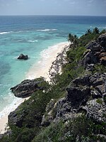
Mona is a mainly flat plateau surrounded by sea cliffs. It is composed of dolomite and limestone with many caves found throughout. With an arid climate and untouched by human development, many endemic species inhabit the island, such as the Mona ground iguana (Cyclura cornuta stejnegeri). Its topography, ecology, and modern history are similar to that of Navassa Island, a small limestone island located in the Jamaica Channel, between Jamaica and Haiti.
Caves

There are around 200 caves, including El gato, La esperanza, La negra, Los ingleses, El rifle, El toro, Del norte, Ataúd, Nuevos Lirios and Gallinas[2] on Isla de Mona, with thousands of examples of native art, marks and later on, graffiti.[18][19][20]
Climate
The Isla de Mona has a tropical savanna climate (Aw according to the Köppen climate classification), with a dry season and wet season and the temperature being warm year-round. The average annual mean is 26.6 °C (79.9 °F), an average annual high is 31.7 °C (89.1 °F) and an average annual low is 21.5 °C (70.7 °F). August, the warmest month, has a mean of 28.3 °C (82.9 °F) and an average high of 33.8 °C (92.8 °F), while the coolest month, January, has a mean of 24.8 °C (76.6 °F) and an average low of 20.3 °C (68.5 °F), although February has a lower average low at 20.0 °C (68.0 °F).
On 2 July 1996, the Isla de Mona recorded a temperature of 40.0 °C (104.0 °F), which is the highest temperature to have ever been recorded in Puerto Rico.[21]
Isla de Mona receives 986 millimetres (38.8 in) of precipitation annually over 126.5 precipitation days. Due to tropical cyclones, autumn is the wettest season, while winter is the driest. The wettest month is May, which receives 125 millimetres (4.9 in) of precipitation on average. October has 12.7 precipitation days on average, which is the highest of any month. January is the driest month, receiving 41 millimetres (1.6 in), while April has the least precipitation days (8.3).
| Climate data for Mona Island, Puerto Rico (1991–2020 normals, extremes 1980–2010) | |||||||||||||
|---|---|---|---|---|---|---|---|---|---|---|---|---|---|
| Month | Jan | Feb | Mar | Apr | May | Jun | Jul | Aug | Sep | Oct | Nov | Dec | Year |
| Record high °F (°C) | 96 (36) |
96 (36) |
97 (36) |
99 (37) |
98 (37) |
103 (39) |
104 (40) |
105 (41) |
102 (39) |
97 (36) |
98 (37) |
96 (36) |
105 (41) |
| Mean maximum °F (°C) | 88.3 (31.3) |
88.3 (31.3) |
90.1 (32.3) |
93.0 (33.9) |
93.4 (34.1) |
94.6 (34.8) |
94.9 (34.9) |
95.7 (35.4) |
94.8 (34.9) |
93.6 (34.2) |
92.4 (33.6) |
89.4 (31.9) |
96.4 (35.8) |
| Mean daily maximum °F (°C) | 84.8 (29.3) |
85.7 (29.8) |
85.9 (29.9) |
88.5 (31.4) |
90.2 (32.3) |
92.1 (33.4) |
92.3 (33.5) |
92.8 (33.8) |
91.9 (33.3) |
91.0 (32.8) |
87.6 (30.9) |
86.1 (30.1) |
89.1 (31.7) |
| Daily mean °F (°C) | 76.6 (24.8) |
76.8 (24.9) |
77.3 (25.2) |
78.8 (26.0) |
80.6 (27.0) |
82.4 (28.0) |
82.5 (28.1) |
83.0 (28.3) |
82.2 (27.9) |
81.4 (27.4) |
79.6 (26.4) |
77.5 (25.3) |
79.9 (26.6) |
| Mean daily minimum °F (°C) | 68.5 (20.3) |
68.0 (20.0) |
68.7 (20.4) |
69.2 (20.7) |
71.1 (21.7) |
72.8 (22.7) |
72.6 (22.6) |
73.3 (22.9) |
72.4 (22.4) |
71.9 (22.2) |
71.5 (21.9) |
68.9 (20.5) |
70.7 (21.5) |
| Mean minimum °F (°C) | 64.6 (18.1) |
64.8 (18.2) |
65.2 (18.4) |
65.3 (18.5) |
67.1 (19.5) |
69.4 (20.8) |
68.2 (20.1) |
69.4 (20.8) |
69.1 (20.6) |
69.6 (20.9) |
67.1 (19.5) |
66.3 (19.1) |
61.5 (16.4) |
| Record low °F (°C) | 57 (14) |
58 (14) |
58 (14) |
61 (16) |
57 (14) |
61 (16) |
57 (14) |
60 (16) |
61 (16) |
61 (16) |
59 (15) |
60 (16) |
57 (14) |
| Average precipitation inches (mm) | 1.61 (41) |
1.64 (42) |
2.17 (55) |
2.43 (62) |
4.92 (125) |
2.50 (64) |
2.30 (58) |
4.22 (107) |
4.74 (120) |
4.49 (114) |
3.82 (97) |
3.99 (101) |
38.83 (986) |
| Average precipitation days (≥ 0.01 in) | 10.6 | 8.3 | 8.8 | 8.3 | 11.6 | 9.3 | 11.8 | 11.2 | 10.9 | 12.7 | 12.5 | 10.5 | 126.5 |
| Source 1: NOAA[22] | |||||||||||||
| Source 2: XMACIS2 (mean maxima/minima 1991–2020)[23] | |||||||||||||
Land cover
Four types of land cover can be identified:[24]
- Cactus (4.35 square miles) (11.27 km2)
- Highland forest (15.55 square miles) (40.28 km2)
- Central Depression forest (0.57 square miles) (1.47 km2)
- Coastal forest (1.46 square miles) (3.77 km2)
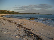
Beaches
Mona Island hosts a large and increasing hawksbill sea turtle (Eretmochelys imbricata) rookery with over 1,500 clutches laid annually on its beaches. The island is recognized as one of the principal sites for hawksbill nesting in the Wider Caribbean and Western Atlantic region, along with Mexico (Yucatán peninsula beaches), Barbados, Panama (Bocas del Toro), and Brazil.[25]
-
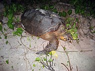 Critically endangered hawksbill turtle
 -
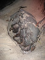 Nesting hawksbill
 -
 Playa Escalera
 -
 Playa Mujeres
 -
 Playa Pájaros
 -
 Playa Sardinera


|
Southeast beaches
|
Southwest beaches
|
Western beaches
|
The only campsites are at Playa de Pájaros and Playa Sardinera. In addition, Playa Uveros, Pájaros, Playa Mujeres and Playa Brava are important to visitors.
Mona Island today


The island presently serves as a retreat for Puerto Ricans and nature enthusiasts from all around the world, and has also become a popular destination for Puerto Rican Boy and Girl Scouts. Due to the islands' unique topography, ecology and location, Mona, Desecheo and Monito have been nicknamed "The Galápagos Islands of the Caribbean". Scientists, ecologists, and students have visited Mona Island to explore its distinct ecosystem, which includes the endemic Mona ground iguana. The island is also home to many cave drawings that were left behind by the island's original inhabitants. Remains of the guano mining industry can also be seen.
An FAA-certified airport that can handle small aircraft was built by the Puerto Rican government. This airport has no ICAO or IATA code. The United States Coast Guard is able to provide transportation with helicopter flights from Rafael Hernández Airport in Aguadilla, to help with medicines and first aid equipment; they also fly whenever an emergency requiring hospitalization occurs. Private and commercial planes require a special permit issued by the Puerto Rico Department of Natural Resources to use the airport's facilities.
The most common form of transportation is by private yacht, though commercial excursions are available from Cabo Rojo for small groups of up to twelve people traveling together.
Hunting is permitted in season in order to control the population growth of non-indigenous species (goats and wild boars)[26] because they can represent a threat to various endangered species. The hunting season usually commences in December and ends in April. Camping is allowed from May through November.
In recent years, the island has become a major drop-off point especially for Dominicans, as well as Haitians and Cubans trying to reach Puerto Rico illegally. As a U.S. Commonwealth, Puerto Rico is seen by many undocumented migrants as a stepping stone to the United States, but they are usually deported immediately.[27]
Due to the island's natural and cultural importance there has been interest in seeking world heritage status for Mona as a UNESCO World Heritage Site by the Puerto Rican government.[28]
Gallery
Scenes around Isla de Mona:
-
 Mona Island cave
 -
 Cueva del Diamante on Isla Mona
 -
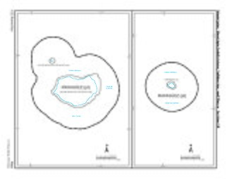 US 2010 Census map of the two islands (Isla de Mona) and (Monito Island)
 -
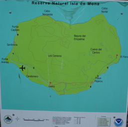 Mona overview map
 -


See also
References
- ^ a b "National Register Information System". National Register of Historic Places. National Park Service. March 13, 2009.
- ^ a b "Reserva Natural Isla de Mona" [Mona Island Nature Reserve] (in Spanish). Archived from the original on 30 June 2016. Retrieved 9 June 2016.
- ^ "National Natural Landmarks - National Natural Landmarks (U.S. National Park Service)". www.nps.gov. Retrieved 2021-11-28.
- ^ "National Natural Landmarks (U.S. National Park Service)". www.nps.gov. Retrieved 2021-11-28.
- ^ "Mona Island, Puerto Rico". Island Conservation. Retrieved 2021-11-28.
- ^ Powell, Eric A. (7 December 1941). "Spiritual Meeting Ground". Archaeology Magazine. Archived from the original on 5 November 2019. Retrieved 5 November 2019.
- ^ Caribbean Prehistory Archived 2007-08-16 at the Wayback Machine, US National Park Service website
- ^ Daley, Jason. "Archaeologists Date Pre-Hispanic Puerto Rican Rock Art for the First Time". Smithsonian. Washington D.C.: Smithsonian Institution. Archived from the original on February 20, 2019. Retrieved November 2, 2017.
- ^ Vicente Yañez Pinzón was appointed as the first governor of Puerto Rico but he never arrived on the island
- ^ "Hunters Flock to Puerto Rico's Remote and Rugged Mona Island" Archived 2007-09-30 at the Wayback Machine, Puerto Rico Herald, June 18, 2003
- ^ "History of the guano mining industry, Isla de Mona, Puerto Rico" Archived 2006-08-24 at the Wayback Machine, Edward F. Frank
- ^ Joseph Prentiss Sanger; Henry Gannett; Walter Francis Willcox (1900). Informe sobre el censo de Puerto Rico, 1899, United States. War Dept. Porto Rico Census Office (in Spanish). Imprenta del gobierno. p. 164.
- ^ Kraig Anderson: Isla de Mona Lighthouse. Archived 2018-08-25 at the Wayback Machine Retrieved on 25 August 2018.
- ^ "Sank Stern First". Ships of the Esso Fleet in World War II. Standard Oil Company of New Jersey. 1946. p. 262. Retrieved 1 October 2022 – via Project Liberty Ship.
- ^ Mona and Monito Islands an Assessment of their Natural and Historical Resources, assessment team directed by Frank H. Wadsworth, maps by John J. Whelan
- ^ United States Department of the Interior, National Park Service (October 29, 1993). "NATIONAL REGISTER OF HISTORIC PLACES REGISTRATION FORM for Amona" (PDF). oech.pr.gov.
- ^ "US Census (2000)". Archived from the original on 2020-02-14. Retrieved 2006-06-06.
- ^ "Cave Walls Record Early Encounters Between Old World and New". 2016-07-19. Archived from the original on 2016-07-21. Retrieved 2016-07-20.
- ^ Cooper, Jago; Samson, Alice V.M.; Nieves, Miguel A.; Lace, Michael J.; Caamaño-Dones, Josué; Cartwright, Caroline; Kambesis, Patricia N.; Frese, Laura del Olmo (2016-08-01). "'The Mona Chronicle': the archaeology of early religious encounter in the New World". Antiquity. 90 (352): 1054–1071. doi:10.15184/aqy.2016.103. hdl:2381/37561. ISSN 1745-1744.
- ^ "Karst development and speleogenesis, Isla de Mona, Puerto Rico". Research gate. Retrieved 24 September 2021.
- ^ "All Time Extremes for PR and VI". National Weather Service. Archived from the original on 19 January 2017. Retrieved 19 January 2017.
- ^ "Summary of Monthly Normals 1991-2020". National Oceanic and Atmospheric Administration. Archived from the original on 2021-07-13. Retrieved July 13, 2021.
- ^ "xmACIS2". National Oceanic and Atmospheric Administration. Retrieved August 28, 2023.
- ^ Departamento de Recursos Naturales y Ambientales website Archived 2004-12-26 at the Wayback Machine (Puerto Rican Department of Natural and Environmental Resources; in Spanish)
- ^ "Conservation Status of Hawksbill Turtles in the Wider Caribbean, Western Atlantic and Eastern Pacific Regions" Archived 2016-09-19 at the Wayback Machine, Campbell, C.L. 2014. Conservation Status of Hawksbill Turtles in the Wider Caribbean, Western Atlantic and Eastern Pacific Regions. IAC Secretariat Pro Tempore, Virginia USA. 76p
- ^ "Se autoriza con restricciones la cacería en la Isla de Mona durante la temporada de diciembre a abril". DRNA. 2015-04-22. Archived from the original on 2021-08-22. Retrieved 2021-08-22.
- ^ "Cubans using Haitian, Dominican soil to reach Puerto Rico concerns the U.S." Archived 2007-11-12 at the Wayback Machine, Dominican Today, accessed 20 April 2007
- ^ CyberNews. "Quiere que Isla de Mona sea un patrimonio". www.wapa.tv (in Spanish). Retrieved 2021-11-28.
External links
- Isla de Mona, Puerto Rico - Photos and Info
- Article on Cuban refugees arriving on Mona Island
- History of Mona Island (in Spanish)
- NOAA: Tides and Currents for Isla de Mona (updated regularly)
- Discover Puerto Rico - Mona Island
| International | |
|---|---|
| National | |
| Other | |
- Beaches of Puerto Rico
- National Register of Historic Places in Mayagüez, Puerto Rico
- Uninhabited islands of Puerto Rico
- National Natural Landmarks in Puerto Rico
- Pirate treasure
- Pirate dens and locations
- Protected areas of Puerto Rico
- Historic districts on the National Register of Historic Places in Puerto Rico
- Archaeological sites on the National Register of Historic Places in Puerto Rico
- Island restoration
- Civilian Conservation Corps in Puerto Rico