
Boeschepe: Difference between revisions
Content deleted Content added
No edit summary |
RodRabelo7 (talk | contribs) |
||
| (29 intermediate revisions by 19 users not shown) | |||
| Line 1: | Line 1: | ||
{{Use dmy dates|date=August 2023}} |
|||
{{Infobox French commune |
{{Infobox French commune |
||
|name = Boeschepe |
|name = Boeschepe |
||
|commune status = [[Communes of France|Commune]] |
|||
|image coat of arms = Blason de la ville de Boeschepe (59) Nord-France.svg |
|image coat of arms = Blason de la ville de Boeschepe (59) Nord-France.svg |
||
|image = 3492 BoeschepeViewCloser.jpg |
|image = 3492 BoeschepeViewCloser.jpg |
||
| |
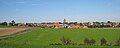
|caption = A general view of Boeschepe |
||
|department = Nord |
|||
|arrondissement = Dunkerque |
|arrondissement = Dunkerque |
||
|canton = |
|canton = Bailleul |
||
|INSEE = 59086 |
|INSEE = 59086 |
||
|postal code = 59299 |
|postal code = 59299 |
||
|mayor = Luc Van Inghelandt<ref>{{cite web|title=Répertoire national des élus: les maires|url=https://www.data.gouv.fr/en/datasets/r/2876a346-d50c-4911-934e-19ee07b0e503|website=data.gouv.fr, Plateforme ouverte des données publiques françaises|date=9 August 2021|language=fr}}</ref> |
|||
|mayor = Pierre Bourgeois |
|||
|term = |
|term = 2020–2026 |
||
|intercommunality = |
|intercommunality = [[Communauté de communes de Flandre Intérieure|CC Flandre Intérieure]] |
||
| |
|coordinates = {{coord|50.8003|2.6919|format=dms|display=inline,title}} |
||
|latitude = 50.8003 |
|||
|elevation m = 74 |
|elevation m = 74 |
||
|elevation min m = 28 |
|elevation min m = 28 |
||
|elevation max m = 153 |
|elevation max m = 153 |
||
|area km2 = 13.59 |
|area km2 = 13.59 |
||
|population = |
|population = {{France metadata Wikidata|population_total}} |
||
|population date = |
|population date = {{France metadata Wikidata|population_as_of}} |
||
|population footnotes = {{France metadata Wikidata|population_footnotes}} |
|||
}} |
}} |
||
'''Boeschepe''' is a [[Communes of France|commune]] in the [[Nord (department)|Nord]] [[Departments of France|department]] in northern [[France]], next to the [[Belgium|Belgian]] border. |
'''Boeschepe''' ({{IPA|fr|bɔskɛp}}) is a [[Communes of France|commune]] in the [[Nord (French department)|Nord]] [[Departments of France|department]] in northern [[France]], next to the [[Belgium|Belgian]] border.<ref>[https://www.insee.fr/fr/metadonnees/geographie/commune/59086-boeschepe INSEE commune file]</ref> |
||
==Population== |
==Population== |
||
{{Historical populations |
{{Historical populations |
||
|align= |
|align = none |
||
|cols = 2 |
|||
| ⚫ | |||
|percentages = pagr |
|||
| 1800 | 1473 |
|||
|source = EHESS<ref name=ehess>{{Cassini-Ehess|4590|Boeschepe}}</ref> and INSEE (1968-2017)<ref name=pophist>[https://www.insee.fr/fr/statistiques/4515315?geo=COM-59086#ancre-POP_T1 Population en historique depuis 1968], INSEE</ref> |
|||
| 1806 | 1692 |
|||
| ⚫ | |||
|1821 |1862 |
|||
| 1831 | 1935 |
|||
| ⚫ | |||
| 1836 | 1975 |
|||
| ⚫ | |||
| 1841 | 1938 |
|||
| ⚫ | |||
| ⚫ | |||
| ⚫ | |||
| 1851 | 1985 |
|||
| ⚫ | |||
| 1856 | 1954 |
|||
| ⚫ | |||
| 1861 | 2011 |
|||
| ⚫ | |||
| 1866 | 2103 |
|||
| ⚫ | |||
| ⚫ | |||
| ⚫ | |||
| 1876 | 2241 |
|||
| ⚫ | |||
| 1881 | 2175 |
|||
| ⚫ | |||
| 1886 | 2222 |
|||
|2007 |2201 |
|||
| 1891 | 2234 |
|||
|2012 |2188 |
|||
| 1896 | 2208 |
|||
|2017 |2183 |
|||
| ⚫ | |||
| 1906 | 2284 |
|||
| 1911 | 2180 |
|||
| 1921 | 2064 |
|||
| ⚫ | |||
| 1931 | 1969 |
|||
| 1936 | 2058 |
|||
| ⚫ | |||
| 1954 | 2089 |
|||
| ⚫ | |||
| ⚫ | |||
| ⚫ | |||
| ⚫ | |||
| ⚫ | |||
| ⚫ | |||
| 2006 | 2177 |
|||
| 2009 | 2202 |
|||
}} |
}} |
||
{{clear-left}} |
|||
==Heraldry== |
==Heraldry== |
||
| Line 76: | Line 60: | ||
==References== |
==References== |
||
* [http://www.insee.fr/fr/methodes/nomenclatures/cog/fichecommunale.asp?codedep=59&codecom=086 INSEE commune file] |
|||
{{reflist}} |
{{reflist}} |
||
<gallery> |
<gallery> |
||
Image:3493 BoeschepeMairie.jpg| |
Image:3493 BoeschepeMairie.jpg|Town hall |
||
Image:3491 BoeschepeView.jpg|View of Boeschepe from the south |
Image:3491 BoeschepeView.jpg|View of Boeschepe from the south |
||
File:Boeschepe - Ondankmeulen 1.jpg|The ''Ondankmeulen'' (unthankfullness windmill) |
File:Boeschepe - Ondankmeulen 1.jpg|The ''Ondankmeulen'' (unthankfullness windmill) |
||
</gallery> |
</gallery> |
||
{{commons category|Boeschepe}} |
|||
{{Commonscat}} |
|||
{{Nord communes}} |
{{Nord communes}} |
||
{{authority control}} |
|||
[[Category:Communes of Nord (French department)]] |
[[Category:Communes of Nord (French department)]] |
||
[[Category:French Flanders]] |
|||
{{Nord-geo-stub}} |
{{Nord-geo-stub}} |
||
[[br:Boeschepe]] |
|||
[[ca:Boeschepe]] |
|||
[[ceb:Boeschepe]] |
|||
[[de:Boeschepe]] |
|||
[[es:Boeschepe]] |
|||
[[eu:Boeschepe]] |
|||
[[fr:Boeschepe]] |
|||
[[it:Boeschepe]] |
|||
[[la:Boeschepe]] |
|||
[[ms:Boeschepe]] |
|||
[[nl:Boeschepe]] |
|||
[[oc:Boeschepe]] |
|||
[[pl:Boeschepe]] |
|||
[[ro:Boeschepe]] |
|||
[[sk:Bœschepe]] |
|||
[[sr:Боешеп]] |
|||
[[sv:Boeschepe]] |
|||
[[uk:Бешеп]] |
|||
[[vi:Boeschepe]] |
|||
[[vo:Boeschepe]] |
|||
[[vls:Boeschepe]] |
|||
[[war:Boeschepe]] |
|||
[[zh:博舍普]] |
|||
Latest revision as of 00:21, 25 August 2024
Boeschepe | |
|---|---|
 A general view of Boeschepe | |
_Nord-France.svg) Coat of arms | |
Location of Boeschepe  | |
 Boeschepe  Boeschepe | |
| Coordinates: 50°48′01″N 2°41′31″E / 50.8003°N 2.6919°E | |
| Country | France |
| Region | Hauts-de-France |
| Department | Nord |
| Arrondissement | Dunkerque |
| Canton | Bailleul |
| Intercommunality | CC Flandre Intérieure |
| Government | |
| • Mayor (2020–2026) | Luc Van Inghelandt[1] |
| Area 1 | 13.59 km2 (5.25 sq mi) |
| Population (2021)[2] | 2,179 |
| • Density | 160/km2 (420/sq mi) |
| Time zone | UTC+01:00 (CET) |
| • Summer (DST) | UTC+02:00 (CEST) |
| INSEE/Postal code | 59086 /59299 |
| Elevation | 28–153 m (92–502 ft) (avg. 74 m or 243 ft) |
| 1 French Land Register data, which excludes lakes, ponds, glaciers > 1 km2 (0.386 sq mi or 247 acres) and river estuaries. | |
Boeschepe (French pronunciation: [bɔskɛp]) is a commune in the Nord department in northern France, next to the Belgian border.[3]
Population
[edit]
|
| ||||||||||||||||||||||||||||||||||||||||||||||||||||||
| Source: EHESS[4] and INSEE (1968-2017)[5] | |||||||||||||||||||||||||||||||||||||||||||||||||||||||
Heraldry
[edit] |
The arms of Boeschepe are blazoned : Or, 3 chevrons sable. (Bersillies, Boeschepe, Boussières-sur-Sambre, Colleret, Cousolre, Flaumont-Waudrechies, Hautmont, Limont-Fontaine, Lompret, Masny, Neuville-en-Avesnois and Saint-Rémy-du-Nord use the same arms.)
|
See also
[edit]References
[edit]- ^ "Répertoire national des élus: les maires". data.gouv.fr, Plateforme ouverte des données publiques françaises (in French). 9 August 2021.
- ^ "Populations légales 2021" (in French). The National Institute of Statistics and Economic Studies. 28 December 2023.
- ^ INSEE commune file
- ^ Des villages de Cassini aux communes d'aujourd'hui: Commune data sheet Boeschepe, EHESS (in French).
- ^ Population en historique depuis 1968, INSEE
-
 Town hall
 -
 View of Boeschepe from the south
 -
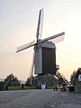 The Ondankmeulen (unthankfullness windmill)


Wikimedia Commons has media related to Boeschepe.
| International | |
|---|---|
| National | |
This Nord geographical article is a stub. You can help Wikipedia by expanding it. |