
Ovidiopol: Difference between revisions
Citation bot (talk | contribs) Added title. Changed bare reference to CS1/2. | Use this bot. Report bugs. | Suggested by Grimes2 | #UCB_webform 445/475 |
|||
| (44 intermediate revisions by 21 users not shown) | |||
| Line 1: | Line 1: | ||
{{short description| |
{{short description|Rural settlement in Odesa Oblast, Ukraine}} |
||
{{Infobox settlement |
{{Infobox settlement |
||
| name |
| name = Ovidiopol |
||
| native_name |
| native_name = Ові́діополь |
||
| native_name_lang |
| native_name_lang = uk |
||
| settlement_type |
| settlement_type = [[Populated places in Ukraine#Rural settlements|Rural settlement]] |
||
| image_skyline |
| image_skyline = Церква Миколи Угодника.jpg |
||
| image_caption |
| image_caption = Church of Saint Mykola, the Miracleworker |
||
| image_flag |
| image_flag = |
||
| image_shield |
| image_shield = Ovidyopol gerb.png |
||
| pushpin_map |
| pushpin_map = Ukraine#Ukraine Odesa Oblast |
||
| pushpin_label_position= |
| pushpin_label_position = |
||
| pushpin_map_alt= |
| pushpin_map_alt = |
||
| pushpin_map_caption |
| pushpin_map_caption = Location of Ovidiopol |
||
| coordinates |
| coordinates = {{coord|46|14|41|N|30|26|41|E |region:UA_type:city |display=inline,title}} |
||
|subdivision_type |
| subdivision_type = [[List of sovereign states|Country]] |
||
|subdivision_name |
| subdivision_name = {{UKR}} |
||
|subdivision_type1 |
| subdivision_type1 = [[Administrative divisions of Ukraine|Oblast]] |
||
|subdivision_name1 |
| subdivision_name1 = [[Odesa Oblast]] |
||
| subdivision_type2 |
| subdivision_type2 = [[Raions of Ukraine|Raion]] |
||
| subdivision_name2 |
| subdivision_name2 = [[Odesa Raion]] |
||
| subdivision_type3 = [[Hromada]] |
|||
| ⚫ | |||
| subdivision_name3 = [[Ovidiopol settlement hromada]] |
|||
| ⚫ | |||
| ⚫ | |||
| leader_party= |
|||
| ⚫ | |||
| ⚫ | |||
| |
| leader_party = |
||
| |
| leader_title = Mayor |
||
| ⚫ | |||
| ⚫ | |||
| |
| unit_pref = Metric<!-- or US or UK --> |
||
| ⚫ | |||
| ⚫ | |||
| area_total_km2 = 12.52 |
|||
| ⚫ | |||
| ⚫ | |||
| ⚫ | |||
| ⚫ | |||
| area_note= |
|||
| ⚫ | |||
| ⚫ | |||
| |
| area_note = |
||
| ⚫ | |||
| ⚫ | |||
| |
| elevation_m = 16 |
||
| ⚫ | |||
| ⚫ | |||
| population_total = 11407 |
|||
| ⚫ | |||
| ⚫ | |||
| population_note= |
|||
| ⚫ | |||
| ⚫ | |||
| |
| population_note = |
||
| |
| timezone = EET |
||
| |
| utc_offset = +2 |
||
| |
| timezone_DST = EEST |
||
| |
| utc_offset_DST = +3 |
||
| |
| postal_code_type = [[Postal code]] |
||
| |
| postal_code = 67800—805 |
||
| area_code_type = [[Telephone numbering plan|Area code]] |
|||
| ⚫ | |||
| area_code = +380 4851 |
|||
| footnotes= |
|||
| ⚫ | |||
| ⚫ | |||
| module = {{Infobox mapframe |wikidata=yes |zoom=11 |frame-height=300 | stroke-width=1 |shape-fill-opacity=0.2 |coord={{WikidataCoord|display=i}}}} |
|||
}} |
}} |
||
[[File:Yedisan.jpg|thumb|Odzider on Dniester on the German map of Ochakiv Tartary]] |
[[File:Yedisan.jpg|thumb|Odzider on Dniester on the German map of Ochakiv Tartary]] |
||
| Line 55: | Line 58: | ||
[[File:Map of Voznesensk Namestnichestvo 1796 (small atlas).jpg|thumb|1796 map of Voznesensk Namestnichestvo]] |
[[File:Map of Voznesensk Namestnichestvo 1796 (small atlas).jpg|thumb|1796 map of Voznesensk Namestnichestvo]] |
||
'''Ovidiopol''' ({{lang-uk|Ові́діополь}}; {{lang-ru|Овидиополь}}; {{lang-tr|Hacıdere}}) is a coastal [[ |
'''Ovidiopol''' ({{lang-uk|Ові́діополь}}; {{lang-ru|Овидиополь}}; {{lang-tr|Hacıdere}}) is a coastal [[Populated places in Ukraine#Rural settlements|rural settlement]] in [[Odesa Oblast]], [[Ukraine]]. It is located on the eastern bank of [[Dniester Estuary]] directly across [[Bilhorod-Dnistrovskyi]] and {{convert|40|km|mi|abbr=on}} west of [[Odesa]].<ref name=encycl/> Ovidiopol hosts the administration of [[Ovidiopol settlement hromada]], one of the [[hromada]]s of Ukraine.<ref name="admreform_2020_ovidiopol">{{cite web |title=Овидиопольская громада |url=https://gromada.info/ru/obschina/ovidiopolska/ |publisher=Портал об'єднаних громад України |language=ru}}</ref> Population: {{Ua-pop-est2022|11,407|punct=.}} |
||
==History== |
==History== |
||
{{also|Yedisan}} |
{{see also|Yedisan}} |
||
The place is first mentioned as early as 17th century.<ref name=encycl>Vermenych, Ya. ''[http://resource.history.org.ua/cgi-bin/eiu/history.exe?Z21ID=&I21DBN=EIU&P21DBN=EIU&S21STN=1&S21REF=10&S21FMT=eiu_all&C21COM=S&S21CNR=20&S21P01=0&S21P02=0&S21P03=TRN=&S21COLORTERMS=0&S21STR=Ovidiopol Ovidiopol]''. Encyclopedia of History of Ukraine. 2010</ref> '''Hacıdere''' belonged to Akkerman sanjak of [[Silistra Eyalet]],<ref name=encycl/> or [[Kefe Eyalet]] where Akkerman sanjak was actually located.<ref>Evgeny Khvalkov. ''[https://books.google.com/books?id=ZJguDwAAQBAJ |
The place is first mentioned as early as 17th century.<ref name=encycl>Vermenych, Ya. ''[http://resource.history.org.ua/cgi-bin/eiu/history.exe?Z21ID=&I21DBN=EIU&P21DBN=EIU&S21STN=1&S21REF=10&S21FMT=eiu_all&C21COM=S&S21CNR=20&S21P01=0&S21P02=0&S21P03=TRN=&S21COLORTERMS=0&S21STR=Ovidiopol Ovidiopol]''. Encyclopedia of History of Ukraine. 2010</ref> '''Hacıdere''' belonged to Akkerman sanjak of [[Silistra Eyalet]],<ref name=encycl/> or [[Kefe Eyalet]] where Akkerman sanjak was actually located.<ref>Evgeny Khvalkov. ''[https://books.google.com/books?id=ZJguDwAAQBAJ&dq=Akkerman+Sanca%C4%9F%C4%B1&pg=PT634 The Colonies of Genoa in the Black Sea Region: Evolution and Transformation]''.</ref> At Medieval times Akkerman, at that time known as [[Maurocastrum]], was a trade port of Byzantine and later Genoese colonies out of the Southern coast of Crimea. In mid 18th century Hacıdere was a big populated place with a pier through which was conducted a [[grain trade]].<ref name=encycl/> During the [[Russo-Turkish War (1768–1774)|1768–1774 Russo-Turkish War]], in 1769 Hacıdere was burned down by [[Zaporizhian Cossacks]] led by [[Petro Kalnyshevskyi]].<ref name=encycl/><ref name=imsuovidiopol/> About twenty years later in 1789 (during the [[Russo-Turkish War (1787–1792)|1787–1792 Russo-Turkish War]]) the revived town was stormed and captured by the Russian troops and by the 1791 [[Treaty of Jassy]] was transferred under the Russian administration.<ref name=encycl/><ref name=imsuovidiopol/> Just before it was captured by Russians, the French military engineer [[André-Joseph Lafitte-Clavé]] who visited the area in late 18th century (1787) described that it took them around an hour to swim on a raft from Akkerman to Adzhider.<ref name=eminako>Igor Sapozhnikov. ''[https://www.researchgate.net/publication/327824492_Mavrokastron_-_Bogaz-Konman_a_seaport_and_a_castle_in_the_mouth_of_the_Dniester_Estuary Mavrokastron – Bogaz-Konman: a seaport and a castle in the mouth of the Dniester Estuary]''. Eminako. July 2017</ref> Lafitte-Clavé noted that depth in Dniester in the area is around {{convert|10|feet|meter|abbr=on}}.<ref name=eminako/> |
||
The Adzhider (a Russian adaptation) fortress was built sometime around 1793 (end of 1792)<ref name=encycl/> soon after end of the [[Russo-Turkish War (1787–1792)|1787–1792 Russo-Turkish War]] and was among the three key fortresses in the area along with Hacibey fortress in [[ |
The Adzhider (a Russian adaptation) fortress was built sometime around 1793 (end of 1792)<ref name=encycl/> soon after end of the [[Russo-Turkish War (1787–1792)|1787–1792 Russo-Turkish War]] and was among the three key fortresses in the area along with Hacibey fortress in [[Odesa]] and Middle fortress in [[Tiraspol]]. The fortress had a specially built harbor and was intended to stand against the Ottoman Akkerman Fortress on the other side of the [[Dniester Estuary]] (liman).<ref name=encycl/> The location for the fortress was picked by the Russian field marshal [[Alexander Suvorov]].<ref name=encycl/><ref name=imsuovidiopol/> Construction of fortress was conducting by engineer captain Rester as a [[star fort]] on design of Flemish military engineer [[François Sainte de Wollant]].<ref name=encycl/> The official date of laying the first stone in the fortress is 15 June 1793.<ref name=encycl/> It was this date that in the Russian and the [[Soviet historiography]] was considered as the date of foundation.<ref name=encycl/> In 1795 the Russian Empress [[Catherine the Great]] by hers decree officially renamed the newly built fortress as Ovidiopol.<ref name=encycl/> The fortress was built to protect entrance to [[Dniester]] from the [[Black Sea]], cease Turkish attacks on [[Mykolaiv]] and [[Ochakiv]] and to serve as an intermediate storage of goods between Odesa and Dniester.<ref name=imsuovidiopol/> |
||
The noble Cossack family of [[Skarżyński |Skarzhinsky]] had real estate investments in Ovidiopol during this time.<ref>{{cite web | url=https://www.nikpravda.com.ua/general-skarzhinskij-i-ego-deti-neizvestnoe-o-predstavitelyah-izvestnogo-roda/ | title=Генерал Скаржинский и его дети: неизвестное о представителях известного рода }}</ref> |
|||
| ⚫ | The town was named in 1795 after [[Ovid]],<ref name=encycl/><ref name=imsuovidiopol>[http://imsu-odesa.com/mista-i-sela-odeskoi-oblasti/ovidiopolskyj-rajon/ovidiopol.html Ovidiopol]. [[The History of Cities and Villages of the Ukrainian SSR|History of Cities and Villages of the Ukrainian SSR]].</ref> the Roman poet exiled to the [[Black Sea]] coast, based on the claim of [[Dimitrie Cantemir]] in his ''[[ |
||
| ⚫ | The town was named in 1795 after [[Ovid]],<ref name=encycl/><ref name=imsuovidiopol>[http://imsu-odesa.com/mista-i-sela-odeskoi-oblasti/ovidiopolskyj-rajon/ovidiopol.html Ovidiopol]. [[The History of Cities and Villages of the Ukrainian SSR|History of Cities and Villages of the Ukrainian SSR]].</ref> the Roman poet exiled to the [[Black Sea]] coast, based on the claim of [[Dimitrie Cantemir]] in his ''[[Descriptio Moldaviae]]'' (1714–1716) that a local lake near [[Bilhorod-Dnistrovskyi]] (probably the [[Dniester Liman]] itself, on whose eastern shore the town is located) was named in Romanian ''Lacul Ovidului'' (''Ovid's Lake''). In reality Ovid stayed in Tomis (today Romanian [[Constanta]]).<ref name=imsuovidiopol/> |
||
| ⚫ | With the establishment of the fortress, around it appeared a settlement that in 1795 accounted for 266 people and was part of Tiraspol okrug (district) in Voznesensk Namestnichestvo (vice-royalty).<ref name=imsuovidiopol/> Ovidiopol was granted status of a " |
||
| ⚫ | With the establishment of the fortress, around it appeared a settlement that in 1795 accounted for 266 people and was part of Tiraspol okrug (district) in Voznesensk Namestnichestvo (vice-royalty).<ref name=imsuovidiopol/> Ovidiopol was granted status of a [[supernumerary town]] ("zashtatny gorod").<ref>Panashenko, V. ''[http://resource.history.org.ua/cgi-bin/eiu/history.exe?Z21ID=&I21DBN=EIU&P21DBN=EIU&S21STN=1&S21REF=10&S21FMT=eiu_all&C21COM=S&S21CNR=20&S21P01=0&S21P02=0&S21P03=TRN=&S21COLORTERMS=0&S21STR=Voznesenske_namisnytstvo Voznesensk Namestnichestvo (ВОЗНЕСЕНСЬКЕ НАМІСНИЦТВО)]''. Encyclopedia of History of Ukraine. 2003</ref> In December of 1796 Voznesensk Namestnichestvo was liquidated and the territory became part of [[Novorossiya Governorate]].<ref name=imsuovidiopol/><ref name=encycl/> In the beginning of 19th century Novorossiya Governorate was liquidated and Ovidiopol existed with [[Kherson Governorate]] until the end of [[World War I]] and the [[Russian Civil War]].<ref name=imsuovidiopol/><ref name=encycl/> In 1920-1925 Ovidiopol was in [[Odesa Governorate]].<ref name=imsuovidiopol/><ref name=encycl/> |
||
Until 18 July 2020, Ovidiopol was the administrative center of [[Ovidiopol Raion]]. The raion was abolished in July 2020 as part of the administrative reform of Ukraine, which reduced the number of raions of Odesa Oblast to seven. The area of Ovidiopol Raion was split between Odesa and [[Bilhorod-Dnistrovskyi Raion]]s, with Ovidiopol being transferred to Odesa Raion.<ref>{{Cite news|title=Про утворення та ліквідацію районів. Постанова Верховної Ради України № 807-ІХ.|url=http://www.golos.com.ua/article/333466|access-date=2020-10-03|date=2020-07-18|website=Голос України|language=uk}}</ref><ref>{{cite web |title=Нові райони: карти + склад |url=https://www.minregion.gov.ua/press/news/novi-rajony-karty-sklad/ |publisher=Міністерство розвитку громад та територій України |language=Ukrainian}}</ref> |
|||
Until 26 January 2024, Ovidiopol was designated [[urban-type settlement]]. On this day, a new law entered into force which abolished this status, and Ovidiopol became a rural settlement.<ref name="glavnoe">{{cite news |title=Что изменится в Украине с 1 января |url=https://glavnoe.in.ua/ru/novosti/chto-yzmenytsya-v-ukrayne-s-1-yanvarya |work=glavnoe.in.ua |lang=ru| date=1 January 2024}}</ref> |
|||
==International relations== |
==International relations== |
||
| Line 79: | Line 88: | ||
File:Палац спорту, Овідіополь.jpg|Palace of sports (community gymnasium) |
File:Палац спорту, Овідіополь.jpg|Palace of sports (community gymnasium) |
||
</gallery> |
</gallery> |
||
==References== |
==References== |
||
{{reflist}} |
{{reflist}} |
||
| Line 87: | Line 97: | ||
{{Catherinian pseudo-Hellenization}} |
{{Catherinian pseudo-Hellenization}} |
||
{{ |
{{Authority control}} |
||
[[Category: |
[[Category:Ovidiopol| ]] |
||
[[Category:Odessky Uyezd]] |
[[Category:Odessky Uyezd]] |
||
[[Category: |
[[Category:Rural settlements in Odesa Raion]] |
||
[[Category:Former forts]] |
[[Category:Former forts]] |
||
[[Category:Star forts]] |
[[Category:Star forts]] |
||
[[Category:Ovidiopol settlement hromada]] |
|||
{{Odessa-geo-stub}} |
|||
Latest revision as of 07:50, 24 August 2024
Ovidiopol
Ові́діополь | |
|---|---|
 Church of Saint Mykola, the Miracleworker | |
 Coat of arms | |
 Ovidiopol Location of Ovidiopol  Ovidiopol Ovidiopol (Odesa Oblast) | |
| Coordinates: 46°14′41″N 30°26′41″E / 46.24472°N 30.44472°E | |
| Country | |
| Oblast | Odesa Oblast |
| Raion | Odesa Raion |
| Hromada | Ovidiopol settlement hromada |
| First mentioned | 17th century |
| Area | |
| • Total | 12.52 km2 (4.83 sq mi) |
| Elevation | 16 m (52 ft) |
| Population (2022) | |
| • Total | 11,407 |
| • Density | 910/km2 (2,400/sq mi) |
| Time zone | UTC+2 (EET) |
| • Summer (DST) | UTC+3 (EEST) |
| Postal code | 67800—805 |
| Area code | +380 4851 |
 | |

.jpg)

.jpg)
Ovidiopol (Ukrainian: Ові́діополь; Russian: Овидиополь; Turkish: Hacıdere) is a coastal rural settlement in Odesa Oblast, Ukraine. It is located on the eastern bank of Dniester Estuary directly across Bilhorod-Dnistrovskyi and 40 km (25 mi) west of Odesa.[1] Ovidiopol hosts the administration of Ovidiopol settlement hromada, one of the hromadas of Ukraine.[2] Population: 11,407 (2022 estimate).[3]
History
[edit]The place is first mentioned as early as 17th century.[1] Hacıdere belonged to Akkerman sanjak of Silistra Eyalet,[1] or Kefe Eyalet where Akkerman sanjak was actually located.[4] At Medieval times Akkerman, at that time known as Maurocastrum, was a trade port of Byzantine and later Genoese colonies out of the Southern coast of Crimea. In mid 18th century Hacıdere was a big populated place with a pier through which was conducted a grain trade.[1] During the 1768–1774 Russo-Turkish War, in 1769 Hacıdere was burned down by Zaporizhian Cossacks led by Petro Kalnyshevskyi.[1][5] About twenty years later in 1789 (during the 1787–1792 Russo-Turkish War) the revived town was stormed and captured by the Russian troops and by the 1791 Treaty of Jassy was transferred under the Russian administration.[1][5] Just before it was captured by Russians, the French military engineer André-Joseph Lafitte-Clavé who visited the area in late 18th century (1787) described that it took them around an hour to swim on a raft from Akkerman to Adzhider.[6] Lafitte-Clavé noted that depth in Dniester in the area is around 10 ft (3.0 m).[6]
The Adzhider (a Russian adaptation) fortress was built sometime around 1793 (end of 1792)[1] soon after end of the 1787–1792 Russo-Turkish War and was among the three key fortresses in the area along with Hacibey fortress in Odesa and Middle fortress in Tiraspol. The fortress had a specially built harbor and was intended to stand against the Ottoman Akkerman Fortress on the other side of the Dniester Estuary (liman).[1] The location for the fortress was picked by the Russian field marshal Alexander Suvorov.[1][5] Construction of fortress was conducting by engineer captain Rester as a star fort on design of Flemish military engineer François Sainte de Wollant.[1] The official date of laying the first stone in the fortress is 15 June 1793.[1] It was this date that in the Russian and the Soviet historiography was considered as the date of foundation.[1] In 1795 the Russian Empress Catherine the Great by hers decree officially renamed the newly built fortress as Ovidiopol.[1] The fortress was built to protect entrance to Dniester from the Black Sea, cease Turkish attacks on Mykolaiv and Ochakiv and to serve as an intermediate storage of goods between Odesa and Dniester.[5]
The noble Cossack family of Skarzhinsky had real estate investments in Ovidiopol during this time.[7]
The town was named in 1795 after Ovid,[1][5] the Roman poet exiled to the Black Sea coast, based on the claim of Dimitrie Cantemir in his Descriptio Moldaviae (1714–1716) that a local lake near Bilhorod-Dnistrovskyi (probably the Dniester Liman itself, on whose eastern shore the town is located) was named in Romanian Lacul Ovidului (Ovid's Lake). In reality Ovid stayed in Tomis (today Romanian Constanta).[5]
With the establishment of the fortress, around it appeared a settlement that in 1795 accounted for 266 people and was part of Tiraspol okrug (district) in Voznesensk Namestnichestvo (vice-royalty).[5] Ovidiopol was granted status of a supernumerary town ("zashtatny gorod").[8] In December of 1796 Voznesensk Namestnichestvo was liquidated and the territory became part of Novorossiya Governorate.[5][1] In the beginning of 19th century Novorossiya Governorate was liquidated and Ovidiopol existed with Kherson Governorate until the end of World War I and the Russian Civil War.[5][1] In 1920-1925 Ovidiopol was in Odesa Governorate.[5][1]
Until 18 July 2020, Ovidiopol was the administrative center of Ovidiopol Raion. The raion was abolished in July 2020 as part of the administrative reform of Ukraine, which reduced the number of raions of Odesa Oblast to seven. The area of Ovidiopol Raion was split between Odesa and Bilhorod-Dnistrovskyi Raions, with Ovidiopol being transferred to Odesa Raion.[9][10]
Until 26 January 2024, Ovidiopol was designated urban-type settlement. On this day, a new law entered into force which abolished this status, and Ovidiopol became a rural settlement.[11]
International relations
[edit]Twin towns — Sister cities
[edit]Ovidiopol is twinned with:
Gallery
[edit]-
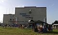 Palace of sports (community gymnasium)

References
[edit]- ^ a b c d e f g h i j k l m n o p q Vermenych, Ya. Ovidiopol. Encyclopedia of History of Ukraine. 2010
- ^ "Овидиопольская громада" (in Russian). Портал об'єднаних громад України.
- ^ Чисельність наявного населення України на 1 січня 2022 [Number of Present Population of Ukraine, as of January 1, 2022] (PDF) (in Ukrainian and English). Kyiv: State Statistics Service of Ukraine. Archived (PDF) from the original on 4 July 2022.
- ^ Evgeny Khvalkov. The Colonies of Genoa in the Black Sea Region: Evolution and Transformation.
- ^ a b c d e f g h i j Ovidiopol. History of Cities and Villages of the Ukrainian SSR.
- ^ a b Igor Sapozhnikov. Mavrokastron – Bogaz-Konman: a seaport and a castle in the mouth of the Dniester Estuary. Eminako. July 2017
- ^ "Генерал Скаржинский и его дети: неизвестное о представителях известного рода".
- ^ Panashenko, V. Voznesensk Namestnichestvo (ВОЗНЕСЕНСЬКЕ НАМІСНИЦТВО). Encyclopedia of History of Ukraine. 2003
- ^ "Про утворення та ліквідацію районів. Постанова Верховної Ради України № 807-ІХ". Голос України (in Ukrainian). 2020-07-18. Retrieved 2020-10-03.
- ^ "Нові райони: карти + склад" (in Ukrainian). Міністерство розвитку громад та територій України.
- ^ "Что изменится в Украине с 1 января". glavnoe.in.ua (in Russian). 1 January 2024.