
Brenner Railway: Difference between revisions
Removing FerroviaDelBrenneroE645aFleres.jpg, it has been deleted from Commons by Ruthven because: Mass deletion of copyrighted or other inappropriate content (see [[:c:Special:Diff/2657163 |
m →top: straight quotes |
||
| (37 intermediate revisions by 22 users not shown) | |||
| Line 1: | Line 1: | ||
{{Short description|Major Austro-Italian transport link}} |
|||
{{Infobox rail line |
{{Infobox rail line |
||
| box_width = auto |
| box_width = auto |
||
| name = Innsbruck–Bozen–Verona railway |
| name = Innsbruck–Bozen–Verona railway |
||
| routenumber = *300 <small>(Salzburg Hbf - Brennero/Brenner)</small> |
| routenumber = *300 <small>(Salzburg Hbf - Brennero/Brenner)</small> |
||
*301 <small>(Jenbach - Telfs-Pfaffenhofen / Steinach in Tirol)</small> |
*301 <small>(Jenbach - Telfs-Pfaffenhofen / Steinach in Tirol)</small> |
||
* 50 <small>(Italy)</small> |
* 50 <small>(Italy)</small> |
||
| linenumber = *302 02 <small>Austria</small> |
| linenumber = *302 02 <small>Austria</small> |
||
* 42 <small>(Brenner–Bozen)</small> |
* 42 <small>(Brenner–Bozen)</small> |
||
* 43 <small>(Bozen–Verona)</small> |
* 43 <small>(Bozen–Verona)</small> |
||
| linelength_km = 275.4 |
| linelength_km = 275.4 |
||
| gauge = {{Track gauge|sg|allk=on}} |
| gauge = {{Track gauge|sg|allk=on}} |
||
| electrification = * 15 kV 16.7 Hz <small>Austria</small> |
| electrification = * 15 kV 16.7 Hz <small>Austria</small> |
||
*3 kV <small>Italy</small> |
*3 kV <small>Italy</small> |
||
| maxincline= *<small>north ramp:</small> 2.5% |
| maxincline = *<small>north ramp:</small> 2.5% |
||
*<small>south ramp:</small> 2.25% |
*<small>south ramp:</small> 2.25% |
||
| minradius = {{convert|264|m|ft|0|abbr=on}} |
| minradius = {{convert|264|m|ft|0|abbr=on}} |
||
| speed = |
| speed = {{convert|180|km/h|mph|0|abbr=on}} |
||
| image |
| image = Eurocity bei Matrei am Brenner.jpg |
||
| image_width = 300px |
| image_width = 300px |
||
| caption = An [[ÖBB|OBB]] [[EuroSprinter]] with a Eurocity train <br /> |
|||
| caption = A regional train passes KM 91,5 towards Matrei station<br />on the late afternoon of All Saint's Day 2016. |
|||
passes KM 91,5 towards Matrei station. |
|||
| locale = Austria and Italy |
|||
| locale = Austria and Italy |
|||
}} |
|||
| map_state = collapsed |
|||
{{BS-map |
|||
| map = [[File:Brennerbahn.png|350px|Map of the Brenner railway]] |
|||
| title = Brenner Railway route |
|||
{{Brenner Railway diagram}} |
|||
| top = Operating points and lines<ref name=Eisenbahnatlas >{{cite book|title=Eisenbahnatlas Österreich (Austrian railway atlas) |publisher= Schweers + Wall | year= 2010 |isbn= 978-3-89494-138-3}}</ref><ref>{{cite book|title=Atlante ferroviario d'Italia e Slovenia (Italian and Slovenian railway atlas) |publisher= Schweers + Wall | year= 2010 |isbn= 978-3-89494-129-1}}</ref> |
|||
| collapsible = yes |
|||
| collapse = yes |
|||
| map = [[File:Brennerbahn.png|350px|Map of the Brenner railway]] |
|||
| map2 = |
|||
{{BS|STR||[[Lower Inn Valley railway|from Kufstein]]}} |
|||
{{BS|BHF|75.130|{{BSsplit|<big>[[Innsbruck Hauptbahnhof|Innsbruck Hbf]]</big>|{{ÖPNV Innsbruck|S1}} {{ÖPNV Innsbruck|S2}} {{ÖPNV Innsbruck|S3}} {{ÖPNV Innsbruck|S4}} {{ÖPNV Innsbruck|S5}} 582 metres [[above mean sea level|m AMSL]]}}}} |
|||
{{BS|ABZgr||[[Arlberg railway|Arlberg]] and [[Mittenwald railway]]s}} |
|||
{{BS|TUNNEL2|76.725||Bergisel tunnel|662m}} |
|||
{{BS|TUNNEL2|78.198||Sonnenburg tunnel|249m}} |
|||
{{BS|ABZg+l|||[[Innsbruck bypass]]|}} |
|||
{{BS|BST|79.646|Innsbruck Hbf 1 junction}} |
|||
{{BS|TUNNEL2|80.291||Ahrnwald tunnel|165m}} |
|||
{{BS|TUNNEL2|80.809||Schupfen tunnel|35m}} |
|||
{{BS|HST|81.295|[[Schönberg im Stubaital|Unterberg]]-Stefansbrücke|{{ÖPNV Innsbruck|S3}} {{ÖPNV Innsbruck|S4}}|5=716 m AMSL}} |
|||
{{BS|TUNNEL2|81.648||Unterberg tunnel|49m}} |
|||
{{BS|TUNNEL2|82.662||Patsch tunnel|176m}} |
|||
{{BS|ÜST|83.905|Innsbruck Hbf 2 crossover}} |
|||
{{BS|HST|84.718|[[Patsch]]|{{ÖPNV Innsbruck|S3}} {{ÖPNV Innsbruck|S4}}|5=784 m AMSL}} |
|||
{{BS|TUNNEL2|85.403||Schönberg tunnel |89m}} |
|||
{{BS|TUNNEL2|85.726||Mühltal tunnel|872m}} |
|||
{{BS|TUNNEL2|86.936||Moserwiese tunnel|74m}} |
|||
{{BS|TUNNEL2|91.847||Matrei tunnel|124m}} |
|||
{{BS|BHF|93.281|[[Matrei am Brenner]]|{{ÖPNV Innsbruck|S3}} {{ÖPNV Innsbruck|S4}}|5=995 m AMSL}} |
|||
{{BS|BHF|97.884|[[Steinach am Brenner|Steinach in Tirol]]|{{ÖPNV Innsbruck|S3}} {{ÖPNV Innsbruck|S4}}|5=1048 m AMSL}} |
|||
{{BS|HST|101.918|[[Vals, Austria|St. Jodok]]|{{ÖPNV Innsbruck|S4}}|5=1141 m AMSL}} |
|||
{{BS|TUNNEL2|102.427||Sankt Jodok [[Spiral tunnels and tunnels on a curved alignment|spiral tunnel]]|480m}} |
|||
{{BS|TUNNEL2|104.323||Stafflach tunnel|283m}} |
|||
{{BS|TUNNEL2|106.189||Gries tunnel|173m}} |
|||
{{BS|HST|106.651|[[Gries am Brenner]]|{{ÖPNV Innsbruck|S4}}|5=1255 m AMSL}} |
|||
{{BS|ÜST|106.917|Steinach in T. 2 crossover}} |
|||
{{BS|eHST|110.9{{0|00}}|[[Brennersee]]|5=1351 m AMSL}} |
|||
{{BS|BST|111.145|Steinach in T. 4 junction|}} |
|||
{{BS3|STR+l|ABZgr||||track 302 11 to the terminal}} |
|||
{{BS3|KDSTe|STR||111.425|Brennersee Terminal|}} |
|||
{{BS|STR+GRZq|111.561||maintenance border ÖBB / RFI}} |
|||
{{BS|GRENZE|{{BSsplit|111.663|240.083|line=1|align=right}}||Border [[Austria]] / [[Italy]]}} |
|||
{{BS|BHF|239.533|[[Brenner railway station|Brennero/Brenner]]|{{ÖPNV Innsbruck|S4}}|5=1371 m AMSL}} |
|||
{{BS|eHST|236.2{{0|00}}||Brennerbad (former [[spa]])|5=1310 m AMSL}} |
|||
{{BS2|BS2+l|eBS2+r|}} |
|||
{{BS2|WBRÜCKE|exWBRÜCKE|||}} |
|||
{{BS2|tSTRa|exTUNNEL2|||}} |
|||
{{BS2|tSTR|exTUNNEL2|||}} |
|||
{{BS2|tSTR|exHST|13.1{{0}}|Moncucco/Schelleberg||6=1242 m AMSL}} |
|||
{{BS2|tSTR|exSTR|||Pflersch tunnel|7.267m}} |
|||
{{BS2|tSTRe|exTUNNEL2|||Ast spiral tunnel|761m}} |
|||
{{BS2|BS2l|eBS2r|}} |
|||
{{BS|eHST|226.7{{0}}||Fleres/Pflersch|5=1130 m AMSL}} |
|||
{{BS|HST|222.8{{0}}||Colle Isarco/Gossensaß|5=1100 m AMSL}} |
|||
{{BS|WBRÜCKE||[[Eisack]] bridge I|1 span}} |
|||
{{BS|BHF|217.0{{0}}|[[Sterzing|Vipiteno/Sterzing]]|5=943 m AMSL}} |
|||
{{BS|HST||[[Freienfeld|Campo di Trens/Freienfeld]]|5=935 m AMSL}} |
|||
{{BS|WBRÜCKE||Palude di Vipiteno bridge|3 spans}} |
|||
{{BS|eHST|208.9{{0}}||Mules/Mauls|5=900 m AMSL}} |
|||
{{BS|eHST|204.3{{0}}||Le Cave/Grasstein|5=843 m AMSL}} |
|||
{{BS|eHST|200.8{{0}}|[[Franzensfeste|Mezzaselva/Mittewald]]|5=798 m AMSL}} |
|||
{{BS|BHF|197.0{{0}}|[[Franzensfeste|Fortezza/Franzensfeste]]|5=747 m AMSL}} |
|||
{{BS|ABZgl|197.0{{0}}||[[Puster Valley railway]] (S.Candido/Innichen)}} |
|||
{{BS|eHST|192.19|[[Vahrn|Varna/Vahrn]]|5=650 m AMSL}} |
|||
{{BS|BHF|188.36|[[Brixen|Bressanone/Brixen]]|5=577 m AMSL}} |
|||
{{BS|WBRÜCKE|||Eisack bridge II|2 spans}} |
|||
{{BS|eHST|184.70|Albès/Albeins|5=548 m AMSL}} |
|||
{{BS|eHST||[[Villnöß|Funes/Villnöß]]|5=539 m AMSL}} |
|||
{{BS|BHF|178.24|[[Klausen, South Tyrol|Chiusa/Klausen]]| [[Grödner railway]]|5=523 m AMSL}} |
|||
{{BS|BHF|172.43||[[Waidbruck|Ponte Gardena/Waidbruck]]|5=422 m AMSL}} |
|||
{{BS2|eBS2+l|BS2+r|}} |
|||
{{BS2|exWBRÜCKE|tSTRa|||Rötele bridge|1 span}} |
|||
{{BS2|exHST|tSTR||[[Kastelruth|Castelrotto/Kastelruth/]]|6=428 m AMSL}} |
|||
{{BS2|exSTR|tSTR|||Schlern tunnel|13.159 m}} |
|||
{{BS2|exHST|tSTR||Campodazzo/Atzwang|6=373 m AMSL}} |
|||
{{BS2|exWBRÜCKE|tSTR|||Eisack bridge I|2 spans}} |
|||
{{BS2|exTUNNEL2|tSTR|||Tunnel VII|55m}} |
|||
{{BS2|exTUNNEL2|tSTR|||Tunnel VI|72m}} |
|||
{{BS2|exTUNNEL2|tSTR|||Tunnel V|60m}} |
|||
{{BS2|exTUNNEL2|tSTR|||Tunnel IV|62m}} |
|||
{{BS2|exTUNNEL2|tSTR|||Tunnel III|79m}} |
|||
{{BS2|exTUNNEL2|tSTR|||Tunnel II|57m}} |
|||
{{BS2|exHST|tSTR||[[Völs am Schlern|Völsersteig/ Fiè allo Sciliar]]|6=340 m AMSL}} |
|||
{{BS2|exTUNNEL2|tSTRe|||Tunnel I|40m}} |
|||
{{BS2|eBS2l|BS2r|}} |
|||
{{BS|eHST|157.99||Prato all'Isarco/Blumau|5=315 m AMSL}} |
|||
{{BS2|eBS2+l|BS2+r|}} |
|||
{{BS2|exSTR|tSTRa|||Kardaun tunnel |3.789m}} |
|||
{{BS2|exTUNNEL2|tSTRe|||Prato Tires tunnel|430m}} |
|||
{{BS2|eBS2l|BS2r|}} |
|||
{{BS|eHST||[[Karneid|Cardano/Kardaun]]|5=283 m AMSL}} |
|||
{{BS|WBRÜCKE|||Kardaun bridge|1 span}} |
|||
{{BS|BHF|150.23|[[Bolzano railway station|Bolzano/Bozen]]|5=266 m AMSL}} |
|||
{{BS|eABZgr|||[[Überetsch Railway]]}} |
|||
{{BS|ABZgr|148.59||[[Bolzano–Merano railway|To Merano]]}} |
|||
{{BS|HST|142.56|[[Laives|Laives/Leifers]]|5=230 m AMSL}} |
|||
{{BS|HST|139.29|[[Bronzolo|Bronzolo/Branzoll]]|5=227 m AMSL}} |
|||
{{BS|HST|134.17|[[Auer, South Tyrol|Ora/Auer]]|5=223 m AMSL}} |
|||
{{BS|WBRÜCKE|||}} |
|||
{{BS|HST|128.40|[[Neumarkt, South Tyrol|Egna/Neumarkt]]|5=217 m AMSL}} |
|||
{{BS|HST|124.42|[[Margreid an der Weinstraße|Magrè/Margreid]]–[[Kurtatsch an der Weinstraße|Cortaccia/Kurtatsch]]|5=216 m AMSL}} |
|||
{{BS|HST|118.99|[[Salorno|Salorno/Salurn]]|5=211 m AMSL}} |
|||
{{BS|HST|111.62|[[Mezzocorona]]}} |
|||
{{BS|WBRÜCKE|||}} |
|||
{{BS|KRZu|110.50||[[Trento-Malè railway]]}} |
|||
{{BS|HST|104.32|[[Lavis]]}} |
|||
{{BS|ABZgl|95.43|Trento goods station}} |
|||
{{BS|BHF|94.79|[[Trento railway station|Trento]]}} |
|||
{{BS|ABZgl|93.01||[[Trento–Venice railway|To Venice]]}} |
|||
{{BS|HST|87.22|[[Mattarello railway station|Mattarello]]}} |
|||
{{BS|TUNNEL1|}} |
|||
{{BS|eHST|78.91|[[Calliano, Trentino|Calliano]],|closed 12.12.2004}} |
|||
{{BS|BHF|71.21|[[Rovereto railway station|Rovereto]]}} |
|||
{{BS|HST|66.91|[[Mori, Trentino|Mori]]|[[Rovereto-Arco-Riva railway]]}} |
|||
{{BS|HST|60.86|[[Ala, Trentino|Serravalle]]}} |
|||
{{BS|HST|54.68|[[Ala, Trentino|Ala]]}} |
|||
{{BS|HST|50.36|[[Avio, Trentino|Avio]]}} |
|||
{{BS|HST|45.48|[[Avio, Trentino|Borghetto]]}} |
|||
{{BS|HST|40.36|[[Dolcè|Peri]]}} |
|||
{{BS|HST|32.77|[[Dolcè]]}} |
|||
{{BS|TUNNEL1|}} |
|||
{{BS|HST|22.80|[[Sant'Ambrogio di Valpolicella|Domegliara–S.Ambrogio]]}} |
|||
{{BS|HST|16.98|[[Pescantina]]}} |
|||
{{BS|eHST|11.65|[[Verona|Verona Parona]]}} |
|||
{{BS|ABZgr+r|6.39||S.Massimo junction/P.C.<ref name=P.C.>"Posti di comunicazione", that is a [[Railroad switch|crossover]].</ref> to [[Milan–Venice railway|Milan]] and [[Verona–Bologna railway|Bologna]]}} |
|||
{{BS|WBRÜCKE|||[[Adige]] river}} |
|||
{{BS|BHF|3.37|[[Verona Porta Nuova railway station|Verona Porta Nuova]]}} |
|||
{{BS|BHF|0.00|[[Verona Porta Vescovo railway station|Verona Porta Vescovo]]}} |
|||
{{BS|STR||| [[Milan–Venice railway|To Venice]]}} |
|||
}} |
}} |
||
[[File:Innsbruck Hbf 001.jpg|thumb|300px|[[Innsbruck Hauptbahnhof|Innsbruck station]] at the north end of the Brenner railway]] |
[[File:Innsbruck Hbf 001.jpg|thumb|300px|[[Innsbruck Hauptbahnhof|Innsbruck station]] at the north end of the Brenner railway]] |
||
The '''Brenner Railway''' ({{lang-de|Brennerbahn}}; {{lang-it|Ferrovia del Brennero}}) is a major line connecting the [[Rail transport in Austria|Austrian]] and [[Rail transport in Italy|Italian railways]] from [[Innsbruck]] to [[Verona Porta Nuova railway station|Verona]], climbing up the [[Wipptal]] ([[German language|German]] for |
The '''Brenner Railway''' ({{lang-de|Brennerbahn}}; {{lang-it|Ferrovia del Brennero}}) is a major line connecting the [[Rail transport in Austria|Austrian]] and [[Rail transport in Italy|Italian railways]] from [[Innsbruck]] to [[Verona Porta Nuova railway station|Verona]], climbing up the [[Wipptal]] ([[German language|German]] for "Wipp Valley"), passing over the [[Brenner Pass]], descending down the [[Eisacktal]] ([[German language|German]] for "Eisack Valley") to [[Bolzano|Bolzano/Bozen]], then further down the [[Adige]] Valley to [[Rovereto|Rovereto/Rofreit]], and along the section of the Adige Valley, called in [[Italian language|Italian]] the "Vallagarina", to Verona. This railway line is part of the [[Berlin–Palermo railway axis|Line 1]] of [[Trans-European Transport Networks]] (TEN-T). It is considered a "fundamental" line by the state railways [[Ferrovie dello Stato]] (FS).<ref>{{cite web|title=Rete FS in esercizio (FS operational network)|language=it|publisher=[[Ferrovie dello Stato]]|url=http://site.rfi.it/img_sito/rete_esercizio.pdf|format=PDF|access-date=4 February 2010|archive-url=https://web.archive.org/web/20110722052055/http://site.rfi.it/img_sito/rete_esercizio.pdf|archive-date=22 July 2011|url-status=dead}}</ref> |
||
==History== |
==History== |
||
The railway line was designed under the [[Austro-Hungarian Empire]] in the mid-19th century to ensure rapid and safe transport between [[Tyrol (state)|Tyrol]] and northern Italy, especially [[ |
The railway line was designed under the [[Austro-Hungarian Empire]] in the mid-19th century to ensure rapid and safe transport between [[Tyrol (state)|Tyrol]] and northern Italy, especially [[Lombardy–Venetia]]. It was thus strategically important not only for economic but also for military reasons, as Austria was strongly committed to maintaining its borders south of the Alps. |
||
The first section to be built was the lower section between Verona and Bolzano/Bozen. The design of this section was approved on 10 July 1853 by the engineer [[Alois Negrelli]], an employee of the ''Südbahn'', known for having built other Alpine railway lines and for developing a project of the [[Suez Canal]]. The section was opened in two different parts: on 23 March 1859 between [[Verona]] to [[Trento|Trento/Trient]] and 16 May 1859 from [[Trento|Trento/Trient]] to [[Bolzano|Bolzano/Bozen]]. This construction was handled by the ''[[Kaiserlich und königlich|k.k.]] Nord- und SüdTiroler Staatsbahn'' (German: "North and South Tyrol State Railways"), but the company was taken over by the new [[Austrian Southern Railway]] (German: ''Südbahn'') at the beginning of 1859.<ref name=kb21>{{Harvnb |Kalla-Bishop|1971| p=21}}</ref> |
The first section to be built was the lower section between Verona and Bolzano/Bozen. The design of this section was approved on 10 July 1853 by the engineer [[Alois Negrelli]], an employee of the ''Südbahn'', known for having built other Alpine railway lines and for developing a project of the [[Suez Canal]]. The section was opened in two different parts: on 23 March 1859 between [[Verona]] to [[Trento|Trento/Trient]] and 16 May 1859 from [[Trento|Trento/Trient]] to [[Bolzano|Bolzano/Bozen]]. This construction was handled by the ''[[Kaiserlich und königlich|k.k.]] Nord- und SüdTiroler Staatsbahn'' (German: "North and South Tyrol State Railways"), but the company was taken over by the new [[Austrian Southern Railway]] (German: ''Südbahn'') at the beginning of 1859.<ref name=kb21>{{Harvnb |Kalla-Bishop|1971| p=21}}</ref> |
||
Despite the loss of [[Veneto]] in the [[Third Italian War of Independence]] and its consequent shift of the border between Italy and Austria to [[Avio, Trentino|Borghetto]] on the current boundary of [[Trentino]] and [[Province of Verona|Verona]] in October 1866, the upper section from Bolzano/Bozen to [[Innsbruck]] was incomplete. The 127 |
Despite the loss of [[Veneto]] in the [[Third Italian War of Independence]] and its consequent shift of the border between Italy and Austria to [[Avio, Trentino|Borghetto]] on the current boundary of [[Trentino]] and [[Province of Verona|Verona]] in October 1866, the upper section from Bolzano/Bozen to [[Innsbruck]] was incomplete. The {{convert|127|km|mi|adj=on}} route from Innsbruck to Bolzano/Bozen took only three years to build. This section had been under construction and was finally opened on 24 August 1867. The main designer and engineer, Karl von Etzel, died in 1865; he was not able to witness the completion of his work. After the [[Semmering railway]], this Brenner Line was the second mountain railway built within the Austro-Hungarian Empire. It was also the first through line to cross over the [[Alps]]. |
||
The section south of Borghetto became part of the [[Società per le strade ferrate dell'Alta Italia]] ([[Italian language|Italian]] for ''Upper (Northern) Italian Railways'', SFAI) in 1866.<ref name=kb41>{{Harvnb |Kalla-Bishop|1971|p=41}}</ref> In the 1885 reorganisation it was absorbed by the [[Società per le Strade Ferrate Meridionali]] (''Adriatic Network'').<ref name=kb52>{{Harvnb |Kalla-Bishop|1971| p=52}}</ref> The line came under the control of Ferrovie dello Stato upon its establishment in 1905. |
The section south of Borghetto became part of the [[Società per le strade ferrate dell'Alta Italia]] ([[Italian language|Italian]] for ''Upper (Northern) Italian Railways'', SFAI) in 1866.<ref name=kb41>{{Harvnb |Kalla-Bishop|1971|p=41}}</ref> In the 1885 reorganisation it was absorbed by the [[Società per le Strade Ferrate Meridionali]] (''Adriatic Network'').<ref name=kb52>{{Harvnb |Kalla-Bishop|1971| p=52}}</ref> The line came under the control of Ferrovie dello Stato upon its establishment in 1905. |
||
| Line 163: | Line 41: | ||
In 1919, Italy acquired [[Trentino-Alto Adige/Südtirol|Trentino-South Tyrol]] under the [[Treaty of Saint-Germain-en-Laye (1919)|Treaty of Saint-Germain-en-Laye]] and the Austro-Italian border moved to [[Brenner, South Tyrol|Brenner]]. The section from Trento/Trient to Brenner was subsequently electrified at 3,700 V at [[three-phase]] 16.7 Hz between 1929 and 1934.<ref name=kb103>{{Harvnb |Kalla-Bishop|1971| p=103}} <!--assuming system same as other lines--></ref> Electrification was converted to 3,000 V [[direct current|DC]] on 30 May 1965. |
In 1919, Italy acquired [[Trentino-Alto Adige/Südtirol|Trentino-South Tyrol]] under the [[Treaty of Saint-Germain-en-Laye (1919)|Treaty of Saint-Germain-en-Laye]] and the Austro-Italian border moved to [[Brenner, South Tyrol|Brenner]]. The section from Trento/Trient to Brenner was subsequently electrified at 3,700 V at [[three-phase]] 16.7 Hz between 1929 and 1934.<ref name=kb103>{{Harvnb |Kalla-Bishop|1971| p=103}} <!--assuming system same as other lines--></ref> Electrification was converted to 3,000 V [[direct current|DC]] on 30 May 1965. |
||
In preparation for the proposed [[Brenner Base Tunnel]], the [[Innsbruck bypass]] was completed in 1994 to improve access to the [[Lower Inn Valley railway]]. The bypass consists of a 12.75 |
In preparation for the proposed [[Brenner Base Tunnel]], the [[Innsbruck bypass]] was completed in 1994 to improve access to the [[Lower Inn Valley railway]]. The bypass consists of a {{convert|12.75|km|mi|adj=on}} tunnel (Austria's longest) and aims to remove the bulk of the freight train traffic from Innsbruck. In Italy, several new sections have been built, removing sections of line with several short tunnels with small cross sections. These include the {{convert|13159|m|ft|adj=mid|-long}} Sciliar tunnel opened in 1994, the {{convert|7267|m|ft|adj=mid|-long}} Pflersch tunnel opened in 1999 and the {{convert|3939|m|ft|adj=mid|-long}} Cardano tunnel opened in 1998. |
||
==Future== |
==Future== |
||
Following a sharp increase in freight traffic through the [[Brenner Pass]] (largely on road), the railway is currently considered to have insufficient capacity. Moreover, its steep grades, tight radius bends and the need to change locomotive engines at [[Brenner railway station|Brenner]] due to two different electrical systems as used in Austria and Italy mean that the average travel speed is low. For these reasons, the creation of a new line is planned from Verona to [[Munich]] via Innsbruck. At the heart of this project lies a 55 |
Following a sharp increase in freight traffic through the [[Brenner Pass]] (largely on road), the railway is currently considered to have insufficient capacity. Moreover, its steep grades, tight radius bends and the need to change locomotive engines at [[Brenner railway station|Brenner]] due to two different electrical systems as used in Austria and Italy mean that the average travel speed is low. For these reasons, the creation of a new line is planned from Verona to [[Munich]] via Innsbruck. At the heart of this project lies a {{convert|55|km|mi|adj=mid|-long}} tunnel between [[Franzensfeste]] and Innsbruck, known as the [[Brenner Base Tunnel]].<ref>{{cite web|url=http://www.bbt-se.com/en/home/ |title=The Brenner Base Tunnel |publisher=Amministrazione trasparente Galleria di Base del Brennero - Brenner Basistunnel BBT SE |access-date=1 January 2016}}</ref> |
||
==Route== |
==Route== |
||
The maximum grade on the track is 31 per thousand. The minimum curve radius is 264 |
The maximum grade on the track is 31 per thousand (3.1%). The minimum curve radius is {{convert|264|m|ft}}. The highest point of the track is [[Brenner, South Tyrol|Brenner]] station at {{convert|1371|m|ft}}, which is also the [[List of highest railways in Europe|highest point reached on the standard gauge networks]] of the [[Austrian Federal Railways]] (ÖBB) and the Italian [[Ferrovie dello Stato]] (FS) networks. |
||
To overcome the steep climb (796 |
To overcome the steep climb ({{convert|796|m|ft}} between Innsbruck and Brenner) two spiral tunnels were built, using the sides of a valley at [[Vals, Austria|St. Jodok]] on the Austrian side and the sides of the [[Pflerschtal]] (German for "Pflersch Valley") on the Italian side. |
||
At Brenner station, located on the Brenner Pass (1371 |
At Brenner station, located on the Brenner Pass ({{convert|1371|m|ft|disp=semicolon}}), there is a monument to the designer, Karl von Etzel. This station is situated at the border between Italy and Austria and also the operational border between the ÖBB and FS networks. The two companies operate different [[Railway electrification system|electrical systems]], (15,000 V [[alternating current|AC]] at 16.7 Hz in Austria, and 3,000 V [[direct current|DC]] in Italy), which requires a stop to change electric locomotives. For this reason, for a long time the operation of express trains from Munich to Verona and Milan was carried out with [[Diesel multiple unit|diesel railcars]]. Until 30 May 1965 was also needed a second engine change in Bolzano station, as the Bolzano–Brenner section still operated under three-phase AC electrification. |
||
In recent years the introduction of multicurrent rolling stock, which can be run on both the Austrian and Italian networks, has made it possible, at least in principle, to avoid locomotive changes. However, the need for locomotives to carry equipment for different signalling systems and to have safety approvals for different networks and lines, and the need for staff to know operating rules and routes has limited multicurrent operations in practice. |
In recent years the introduction of multicurrent rolling stock, which can be run on both the Austrian and Italian networks, has made it possible, at least in principle, to avoid locomotive changes. However, the need for locomotives to carry equipment for different signalling systems and to have safety approvals for different networks and lines, and the need for staff to know operating rules and routes has limited multicurrent operations in practice.<gallery mode="packed" caption="Trains on the Brenner Railway"> |
||
File:ÖBB Italia - Eurocity 80 by Bhf Sankt Jodok - Austria.jpg|An [[ÖBB]] [[EuroSprinter]] on the Brenner railway. |
|||
File:Treno Merci - Val di Fleres.jpg|An [[FS Class E.632|FS Class E.652]] with a train on the Brenner railway. |
|||
==Notes== |
|||
File:ÖBB Cargo (1044 1144 ?) by Sankt Jodok - Tirol - AT (48985188642).jpg|An [[ÖBB Class 1044]] with a train on the Brenner railway. |
|||
{{reflist}} |
|||
File:RTC EU43 2.jpg|[[FS Class E.412]] on the Brenner railway. |
|||
</gallery> |
|||
==References== |
==References== |
||
*{{citation |title=Rete FS in esercizio (FS operational network) |language=Italian |publisher= [[Ferrovie dello Stato]]|url=http://site.rfi.it/img_sito/rete_esercizio.pdf|format=PDF|accessdate=4 February 2010}} |
|||
=== Notes === |
|||
*{{citation| first= L. |last=Facchinelli| title=La ferrovia Verona–Brennero. Storia della linea e delle stazioni nel territorio (the Verona–Brennero railway, history of the lines and stations in the area) |location=Bolzano |language=Italian |publisher= Athesia|year= 1995}} |
|||
{{reflist|group=nb}} |
|||
===Footnotes=== |
|||
{{Reflist}} |
|||
===Sources=== |
|||
*{{citation| first= L. |last=Facchinelli| title=La ferrovia Verona–Brennero. Storia della linea e delle stazioni nel territorio (the Verona–Brennero railway, history of the lines and stations in the area) |location=Bolzano |language=it |publisher= Athesia|year= 1995}} |
|||
*{{citation|title=Italian Railways|first=P. M. |last=Kalla-Bishop | year=1971 |publisher= David & Charles|location =Newton Abbott, Devon, England | isbn=0-7153-5168-0 }} |
*{{citation|title=Italian Railways|first=P. M. |last=Kalla-Bishop | year=1971 |publisher= David & Charles|location =Newton Abbott, Devon, England | isbn=0-7153-5168-0 }} |
||
*{{citation|title=La ferrovia da Verona a Monaco di Baviera (The railway from Verona to Munich)|first= Edoardo|last= Mori|publisher= Calosci Editore |language= |
*{{citation|title=La ferrovia da Verona a Monaco di Baviera (The railway from Verona to Munich)|first= Edoardo|last= Mori|publisher= Calosci Editore |language=it }} |
||
* {{cite web|date = 1927 |url = http://www.trenidicarta.it/aperture.html |title = Prospetto cronologico dei tratti di ferrovia aperti all'esercizio dal 1839 al 31 dicembre 1926 |publisher = Ufficio Centrale di Statistica delle Ferrovie dello Stato/Trenidicarta.it |editor-first = Alessandro |editor-last =Tuzza |language=it |access-date= 6 September 2020 |ref={{SfnRef|Prospetto cronologico|1926}}}} |
|||
* {{cite book|title=Atlante ferroviario d'Italia e Slovenia |trans-title=Railway atlas of Italy and Slovenia|publisher= Schweers + Wall | date = 2010 |isbn= 978-3-89494-129-1|ref={{SfnRef|Railway Atlas|2017}}}}} |
|||
== See also == |
== See also == |
||
| Line 190: | Line 79: | ||
{{Berlin–Palermo railway axis}} |
{{Berlin–Palermo railway axis}} |
||
{{ |
{{Major railway lines in Italy}} |
||
{{coord|46|18|26|N|11|14|51|E|region:AT-7_type:landmark_source:kolossus-dewiki|display=title}} |
{{coord|46|18|26|N|11|14|51|E|region:AT-7_type:landmark_source:kolossus-dewiki|display=title}} |
||
{{Authority control}} |
{{Authority control}} |
||
[[Category:Railway lines in Austria]] |
[[Category:Railway lines in Austria]] |
||
[[Category:Railway lines in Veneto]] |
[[Category:Railway lines in Veneto]] |
||
| Line 201: | Line 90: | ||
[[Category:Standard gauge railways in Austria]] |
[[Category:Standard gauge railways in Austria]] |
||
[[Category:Standard gauge railways in Italy]] |
[[Category:Standard gauge railways in Italy]] |
||
[[Category:Cross-border railway lines in Austria]] |
|||
[[Category:Cross-border railway lines in Italy]] |
|||
[[Category:Transport in the Alps]] |
|||
Latest revision as of 08:20, 17 August 2024
| Innsbruck–Bozen–Verona railway | |||||||||||||||||||||||||||||||||||||||||||||||||||||||||||||||||||||||||||||||||||||||||||||||||||||||||||||||||||||||||||||||||||||||||||||||||||||||||||||||||||||||||||||||||||||||||||||||||||||||||||||||||||||||||||||||||||||||||||||||||||||||||||||||||||||||||||||||||||||||||||||||||||||||||||||||||||||||||||||||||||||||||||||||||||||||||||||||||||||||||||||||||||||||||||||||||||||||||||||||||||||||||||||||||||||||||||||||||||||||||||||||||||||||||||||||||||||||||||||||||||||||||||||||||||||||||||||||||||||||||||||||||||||||||||||||||||||||||||||||||||||||||||||||||||||||||||||||||||||||||||||||||||||||||||||||||||||||||||||||||||||||||||||||||||||||||||||||||||||||||||||||||||||||||||||||||||||||||||||||||||||||||||||||||||||||||||||||||||||||||||||||||||||||||||||||||||||||||||||||||||||||||||||||||||||||||||||||||||||||||||||||||||||||||||
|---|---|---|---|---|---|---|---|---|---|---|---|---|---|---|---|---|---|---|---|---|---|---|---|---|---|---|---|---|---|---|---|---|---|---|---|---|---|---|---|---|---|---|---|---|---|---|---|---|---|---|---|---|---|---|---|---|---|---|---|---|---|---|---|---|---|---|---|---|---|---|---|---|---|---|---|---|---|---|---|---|---|---|---|---|---|---|---|---|---|---|---|---|---|---|---|---|---|---|---|---|---|---|---|---|---|---|---|---|---|---|---|---|---|---|---|---|---|---|---|---|---|---|---|---|---|---|---|---|---|---|---|---|---|---|---|---|---|---|---|---|---|---|---|---|---|---|---|---|---|---|---|---|---|---|---|---|---|---|---|---|---|---|---|---|---|---|---|---|---|---|---|---|---|---|---|---|---|---|---|---|---|---|---|---|---|---|---|---|---|---|---|---|---|---|---|---|---|---|---|---|---|---|---|---|---|---|---|---|---|---|---|---|---|---|---|---|---|---|---|---|---|---|---|---|---|---|---|---|---|---|---|---|---|---|---|---|---|---|---|---|---|---|---|---|---|---|---|---|---|---|---|---|---|---|---|---|---|---|---|---|---|---|---|---|---|---|---|---|---|---|---|---|---|---|---|---|---|---|---|---|---|---|---|---|---|---|---|---|---|---|---|---|---|---|---|---|---|---|---|---|---|---|---|---|---|---|---|---|---|---|---|---|---|---|---|---|---|---|---|---|---|---|---|---|---|---|---|---|---|---|---|---|---|---|---|---|---|---|---|---|---|---|---|---|---|---|---|---|---|---|---|---|---|---|---|---|---|---|---|---|---|---|---|---|---|---|---|---|---|---|---|---|---|---|---|---|---|---|---|---|---|---|---|---|---|---|---|---|---|---|---|---|---|---|---|---|---|---|---|---|---|---|---|---|---|---|---|---|---|---|---|---|---|---|---|---|---|---|---|---|---|---|---|---|---|---|---|---|---|---|---|---|---|---|---|---|---|---|---|---|---|---|---|---|---|---|---|---|---|---|---|---|---|---|---|---|---|---|---|---|---|---|---|---|---|---|---|---|---|---|---|---|---|---|---|---|---|---|---|---|---|---|---|---|---|---|---|---|---|---|---|---|---|---|---|---|---|---|---|---|---|---|---|---|---|---|---|---|---|---|---|---|---|---|---|---|---|---|---|---|---|---|---|---|---|---|---|---|---|---|---|---|---|---|---|---|---|---|---|---|---|---|---|---|---|---|---|---|---|---|---|---|---|---|---|---|---|---|---|---|---|---|---|---|---|---|---|---|---|---|---|---|---|---|---|---|---|---|---|---|---|---|---|---|---|---|---|---|---|---|---|---|---|---|---|---|---|---|---|---|---|---|---|---|---|---|---|---|---|---|---|---|---|---|---|---|---|---|---|---|---|---|---|---|---|---|---|---|---|---|---|---|---|---|---|---|---|---|---|---|---|---|---|---|---|---|---|---|---|---|---|---|---|---|---|---|---|---|---|---|---|---|---|---|---|---|---|---|---|---|---|---|---|---|---|---|---|---|---|---|---|---|---|---|---|---|---|---|---|---|---|---|---|---|---|---|---|---|---|---|---|---|---|---|---|---|---|---|---|---|---|---|---|---|---|---|---|---|---|---|---|---|---|---|---|---|---|---|---|---|---|---|---|---|---|---|---|---|---|---|---|---|---|---|---|---|---|---|---|---|---|---|---|---|---|---|---|---|---|---|---|---|---|---|---|---|---|---|---|---|---|---|---|---|---|---|---|---|---|---|---|---|---|---|---|---|---|---|---|---|---|---|---|---|---|---|---|---|---|---|---|---|---|---|---|---|---|---|---|---|---|---|---|---|---|---|---|---|---|---|---|---|---|---|---|---|---|---|---|---|---|---|---|---|---|---|---|---|---|---|---|---|---|---|---|---|---|---|---|---|---|---|---|---|---|---|---|---|---|
 | |||||||||||||||||||||||||||||||||||||||||||||||||||||||||||||||||||||||||||||||||||||||||||||||||||||||||||||||||||||||||||||||||||||||||||||||||||||||||||||||||||||||||||||||||||||||||||||||||||||||||||||||||||||||||||||||||||||||||||||||||||||||||||||||||||||||||||||||||||||||||||||||||||||||||||||||||||||||||||||||||||||||||||||||||||||||||||||||||||||||||||||||||||||||||||||||||||||||||||||||||||||||||||||||||||||||||||||||||||||||||||||||||||||||||||||||||||||||||||||||||||||||||||||||||||||||||||||||||||||||||||||||||||||||||||||||||||||||||||||||||||||||||||||||||||||||||||||||||||||||||||||||||||||||||||||||||||||||||||||||||||||||||||||||||||||||||||||||||||||||||||||||||||||||||||||||||||||||||||||||||||||||||||||||||||||||||||||||||||||||||||||||||||||||||||||||||||||||||||||||||||||||||||||||||||||||||||||||||||||||||||||||||||||||||||
| Overview | |||||||||||||||||||||||||||||||||||||||||||||||||||||||||||||||||||||||||||||||||||||||||||||||||||||||||||||||||||||||||||||||||||||||||||||||||||||||||||||||||||||||||||||||||||||||||||||||||||||||||||||||||||||||||||||||||||||||||||||||||||||||||||||||||||||||||||||||||||||||||||||||||||||||||||||||||||||||||||||||||||||||||||||||||||||||||||||||||||||||||||||||||||||||||||||||||||||||||||||||||||||||||||||||||||||||||||||||||||||||||||||||||||||||||||||||||||||||||||||||||||||||||||||||||||||||||||||||||||||||||||||||||||||||||||||||||||||||||||||||||||||||||||||||||||||||||||||||||||||||||||||||||||||||||||||||||||||||||||||||||||||||||||||||||||||||||||||||||||||||||||||||||||||||||||||||||||||||||||||||||||||||||||||||||||||||||||||||||||||||||||||||||||||||||||||||||||||||||||||||||||||||||||||||||||||||||||||||||||||||||||||||||||||||||||
| Line number |
| ||||||||||||||||||||||||||||||||||||||||||||||||||||||||||||||||||||||||||||||||||||||||||||||||||||||||||||||||||||||||||||||||||||||||||||||||||||||||||||||||||||||||||||||||||||||||||||||||||||||||||||||||||||||||||||||||||||||||||||||||||||||||||||||||||||||||||||||||||||||||||||||||||||||||||||||||||||||||||||||||||||||||||||||||||||||||||||||||||||||||||||||||||||||||||||||||||||||||||||||||||||||||||||||||||||||||||||||||||||||||||||||||||||||||||||||||||||||||||||||||||||||||||||||||||||||||||||||||||||||||||||||||||||||||||||||||||||||||||||||||||||||||||||||||||||||||||||||||||||||||||||||||||||||||||||||||||||||||||||||||||||||||||||||||||||||||||||||||||||||||||||||||||||||||||||||||||||||||||||||||||||||||||||||||||||||||||||||||||||||||||||||||||||||||||||||||||||||||||||||||||||||||||||||||||||||||||||||||||||||||||||||||||||||||||
| Locale | Austria and Italy | ||||||||||||||||||||||||||||||||||||||||||||||||||||||||||||||||||||||||||||||||||||||||||||||||||||||||||||||||||||||||||||||||||||||||||||||||||||||||||||||||||||||||||||||||||||||||||||||||||||||||||||||||||||||||||||||||||||||||||||||||||||||||||||||||||||||||||||||||||||||||||||||||||||||||||||||||||||||||||||||||||||||||||||||||||||||||||||||||||||||||||||||||||||||||||||||||||||||||||||||||||||||||||||||||||||||||||||||||||||||||||||||||||||||||||||||||||||||||||||||||||||||||||||||||||||||||||||||||||||||||||||||||||||||||||||||||||||||||||||||||||||||||||||||||||||||||||||||||||||||||||||||||||||||||||||||||||||||||||||||||||||||||||||||||||||||||||||||||||||||||||||||||||||||||||||||||||||||||||||||||||||||||||||||||||||||||||||||||||||||||||||||||||||||||||||||||||||||||||||||||||||||||||||||||||||||||||||||||||||||||||||||||||||||||||
| Service | |||||||||||||||||||||||||||||||||||||||||||||||||||||||||||||||||||||||||||||||||||||||||||||||||||||||||||||||||||||||||||||||||||||||||||||||||||||||||||||||||||||||||||||||||||||||||||||||||||||||||||||||||||||||||||||||||||||||||||||||||||||||||||||||||||||||||||||||||||||||||||||||||||||||||||||||||||||||||||||||||||||||||||||||||||||||||||||||||||||||||||||||||||||||||||||||||||||||||||||||||||||||||||||||||||||||||||||||||||||||||||||||||||||||||||||||||||||||||||||||||||||||||||||||||||||||||||||||||||||||||||||||||||||||||||||||||||||||||||||||||||||||||||||||||||||||||||||||||||||||||||||||||||||||||||||||||||||||||||||||||||||||||||||||||||||||||||||||||||||||||||||||||||||||||||||||||||||||||||||||||||||||||||||||||||||||||||||||||||||||||||||||||||||||||||||||||||||||||||||||||||||||||||||||||||||||||||||||||||||||||||||||||||||||||||
| Route number |
| ||||||||||||||||||||||||||||||||||||||||||||||||||||||||||||||||||||||||||||||||||||||||||||||||||||||||||||||||||||||||||||||||||||||||||||||||||||||||||||||||||||||||||||||||||||||||||||||||||||||||||||||||||||||||||||||||||||||||||||||||||||||||||||||||||||||||||||||||||||||||||||||||||||||||||||||||||||||||||||||||||||||||||||||||||||||||||||||||||||||||||||||||||||||||||||||||||||||||||||||||||||||||||||||||||||||||||||||||||||||||||||||||||||||||||||||||||||||||||||||||||||||||||||||||||||||||||||||||||||||||||||||||||||||||||||||||||||||||||||||||||||||||||||||||||||||||||||||||||||||||||||||||||||||||||||||||||||||||||||||||||||||||||||||||||||||||||||||||||||||||||||||||||||||||||||||||||||||||||||||||||||||||||||||||||||||||||||||||||||||||||||||||||||||||||||||||||||||||||||||||||||||||||||||||||||||||||||||||||||||||||||||||||||||||||
| Technical | |||||||||||||||||||||||||||||||||||||||||||||||||||||||||||||||||||||||||||||||||||||||||||||||||||||||||||||||||||||||||||||||||||||||||||||||||||||||||||||||||||||||||||||||||||||||||||||||||||||||||||||||||||||||||||||||||||||||||||||||||||||||||||||||||||||||||||||||||||||||||||||||||||||||||||||||||||||||||||||||||||||||||||||||||||||||||||||||||||||||||||||||||||||||||||||||||||||||||||||||||||||||||||||||||||||||||||||||||||||||||||||||||||||||||||||||||||||||||||||||||||||||||||||||||||||||||||||||||||||||||||||||||||||||||||||||||||||||||||||||||||||||||||||||||||||||||||||||||||||||||||||||||||||||||||||||||||||||||||||||||||||||||||||||||||||||||||||||||||||||||||||||||||||||||||||||||||||||||||||||||||||||||||||||||||||||||||||||||||||||||||||||||||||||||||||||||||||||||||||||||||||||||||||||||||||||||||||||||||||||||||||||||||||||||||
| Line length | 275.4 km (171.1 mi) | ||||||||||||||||||||||||||||||||||||||||||||||||||||||||||||||||||||||||||||||||||||||||||||||||||||||||||||||||||||||||||||||||||||||||||||||||||||||||||||||||||||||||||||||||||||||||||||||||||||||||||||||||||||||||||||||||||||||||||||||||||||||||||||||||||||||||||||||||||||||||||||||||||||||||||||||||||||||||||||||||||||||||||||||||||||||||||||||||||||||||||||||||||||||||||||||||||||||||||||||||||||||||||||||||||||||||||||||||||||||||||||||||||||||||||||||||||||||||||||||||||||||||||||||||||||||||||||||||||||||||||||||||||||||||||||||||||||||||||||||||||||||||||||||||||||||||||||||||||||||||||||||||||||||||||||||||||||||||||||||||||||||||||||||||||||||||||||||||||||||||||||||||||||||||||||||||||||||||||||||||||||||||||||||||||||||||||||||||||||||||||||||||||||||||||||||||||||||||||||||||||||||||||||||||||||||||||||||||||||||||||||||||||||||||||
| Track gauge | 1,435 mm (4 ft 8+1⁄2 in) standard gauge | ||||||||||||||||||||||||||||||||||||||||||||||||||||||||||||||||||||||||||||||||||||||||||||||||||||||||||||||||||||||||||||||||||||||||||||||||||||||||||||||||||||||||||||||||||||||||||||||||||||||||||||||||||||||||||||||||||||||||||||||||||||||||||||||||||||||||||||||||||||||||||||||||||||||||||||||||||||||||||||||||||||||||||||||||||||||||||||||||||||||||||||||||||||||||||||||||||||||||||||||||||||||||||||||||||||||||||||||||||||||||||||||||||||||||||||||||||||||||||||||||||||||||||||||||||||||||||||||||||||||||||||||||||||||||||||||||||||||||||||||||||||||||||||||||||||||||||||||||||||||||||||||||||||||||||||||||||||||||||||||||||||||||||||||||||||||||||||||||||||||||||||||||||||||||||||||||||||||||||||||||||||||||||||||||||||||||||||||||||||||||||||||||||||||||||||||||||||||||||||||||||||||||||||||||||||||||||||||||||||||||||||||||||||||||||
| Minimum radius | 264 m (866 ft) | ||||||||||||||||||||||||||||||||||||||||||||||||||||||||||||||||||||||||||||||||||||||||||||||||||||||||||||||||||||||||||||||||||||||||||||||||||||||||||||||||||||||||||||||||||||||||||||||||||||||||||||||||||||||||||||||||||||||||||||||||||||||||||||||||||||||||||||||||||||||||||||||||||||||||||||||||||||||||||||||||||||||||||||||||||||||||||||||||||||||||||||||||||||||||||||||||||||||||||||||||||||||||||||||||||||||||||||||||||||||||||||||||||||||||||||||||||||||||||||||||||||||||||||||||||||||||||||||||||||||||||||||||||||||||||||||||||||||||||||||||||||||||||||||||||||||||||||||||||||||||||||||||||||||||||||||||||||||||||||||||||||||||||||||||||||||||||||||||||||||||||||||||||||||||||||||||||||||||||||||||||||||||||||||||||||||||||||||||||||||||||||||||||||||||||||||||||||||||||||||||||||||||||||||||||||||||||||||||||||||||||||||||||||||||||
| Electrification |
| ||||||||||||||||||||||||||||||||||||||||||||||||||||||||||||||||||||||||||||||||||||||||||||||||||||||||||||||||||||||||||||||||||||||||||||||||||||||||||||||||||||||||||||||||||||||||||||||||||||||||||||||||||||||||||||||||||||||||||||||||||||||||||||||||||||||||||||||||||||||||||||||||||||||||||||||||||||||||||||||||||||||||||||||||||||||||||||||||||||||||||||||||||||||||||||||||||||||||||||||||||||||||||||||||||||||||||||||||||||||||||||||||||||||||||||||||||||||||||||||||||||||||||||||||||||||||||||||||||||||||||||||||||||||||||||||||||||||||||||||||||||||||||||||||||||||||||||||||||||||||||||||||||||||||||||||||||||||||||||||||||||||||||||||||||||||||||||||||||||||||||||||||||||||||||||||||||||||||||||||||||||||||||||||||||||||||||||||||||||||||||||||||||||||||||||||||||||||||||||||||||||||||||||||||||||||||||||||||||||||||||||||||||||||||||
| Operating speed | 180 km/h (112 mph) | ||||||||||||||||||||||||||||||||||||||||||||||||||||||||||||||||||||||||||||||||||||||||||||||||||||||||||||||||||||||||||||||||||||||||||||||||||||||||||||||||||||||||||||||||||||||||||||||||||||||||||||||||||||||||||||||||||||||||||||||||||||||||||||||||||||||||||||||||||||||||||||||||||||||||||||||||||||||||||||||||||||||||||||||||||||||||||||||||||||||||||||||||||||||||||||||||||||||||||||||||||||||||||||||||||||||||||||||||||||||||||||||||||||||||||||||||||||||||||||||||||||||||||||||||||||||||||||||||||||||||||||||||||||||||||||||||||||||||||||||||||||||||||||||||||||||||||||||||||||||||||||||||||||||||||||||||||||||||||||||||||||||||||||||||||||||||||||||||||||||||||||||||||||||||||||||||||||||||||||||||||||||||||||||||||||||||||||||||||||||||||||||||||||||||||||||||||||||||||||||||||||||||||||||||||||||||||||||||||||||||||||||||||||||||||
| Maximum incline |
| ||||||||||||||||||||||||||||||||||||||||||||||||||||||||||||||||||||||||||||||||||||||||||||||||||||||||||||||||||||||||||||||||||||||||||||||||||||||||||||||||||||||||||||||||||||||||||||||||||||||||||||||||||||||||||||||||||||||||||||||||||||||||||||||||||||||||||||||||||||||||||||||||||||||||||||||||||||||||||||||||||||||||||||||||||||||||||||||||||||||||||||||||||||||||||||||||||||||||||||||||||||||||||||||||||||||||||||||||||||||||||||||||||||||||||||||||||||||||||||||||||||||||||||||||||||||||||||||||||||||||||||||||||||||||||||||||||||||||||||||||||||||||||||||||||||||||||||||||||||||||||||||||||||||||||||||||||||||||||||||||||||||||||||||||||||||||||||||||||||||||||||||||||||||||||||||||||||||||||||||||||||||||||||||||||||||||||||||||||||||||||||||||||||||||||||||||||||||||||||||||||||||||||||||||||||||||||||||||||||||||||||||||||||||||||
| |||||||||||||||||||||||||||||||||||||||||||||||||||||||||||||||||||||||||||||||||||||||||||||||||||||||||||||||||||||||||||||||||||||||||||||||||||||||||||||||||||||||||||||||||||||||||||||||||||||||||||||||||||||||||||||||||||||||||||||||||||||||||||||||||||||||||||||||||||||||||||||||||||||||||||||||||||||||||||||||||||||||||||||||||||||||||||||||||||||||||||||||||||||||||||||||||||||||||||||||||||||||||||||||||||||||||||||||||||||||||||||||||||||||||||||||||||||||||||||||||||||||||||||||||||||||||||||||||||||||||||||||||||||||||||||||||||||||||||||||||||||||||||||||||||||||||||||||||||||||||||||||||||||||||||||||||||||||||||||||||||||||||||||||||||||||||||||||||||||||||||||||||||||||||||||||||||||||||||||||||||||||||||||||||||||||||||||||||||||||||||||||||||||||||||||||||||||||||||||||||||||||||||||||||||||||||||||||||||||||||||||||||||||||||||


The Brenner Railway (German: Brennerbahn; Italian: Ferrovia del Brennero) is a major line connecting the Austrian and Italian railways from Innsbruck to Verona, climbing up the Wipptal (German for "Wipp Valley"), passing over the Brenner Pass, descending down the Eisacktal (German for "Eisack Valley") to Bolzano/Bozen, then further down the Adige Valley to Rovereto/Rofreit, and along the section of the Adige Valley, called in Italian the "Vallagarina", to Verona. This railway line is part of the Line 1 of Trans-European Transport Networks (TEN-T). It is considered a "fundamental" line by the state railways Ferrovie dello Stato (FS).[2]
History
[edit]The railway line was designed under the Austro-Hungarian Empire in the mid-19th century to ensure rapid and safe transport between Tyrol and northern Italy, especially Lombardy–Venetia. It was thus strategically important not only for economic but also for military reasons, as Austria was strongly committed to maintaining its borders south of the Alps.
The first section to be built was the lower section between Verona and Bolzano/Bozen. The design of this section was approved on 10 July 1853 by the engineer Alois Negrelli, an employee of the Südbahn, known for having built other Alpine railway lines and for developing a project of the Suez Canal. The section was opened in two different parts: on 23 March 1859 between Verona to Trento/Trient and 16 May 1859 from Trento/Trient to Bolzano/Bozen. This construction was handled by the k.k. Nord- und SüdTiroler Staatsbahn (German: "North and South Tyrol State Railways"), but the company was taken over by the new Austrian Southern Railway (German: Südbahn) at the beginning of 1859.[3]
Despite the loss of Veneto in the Third Italian War of Independence and its consequent shift of the border between Italy and Austria to Borghetto on the current boundary of Trentino and Verona in October 1866, the upper section from Bolzano/Bozen to Innsbruck was incomplete. The 127-kilometre (79 mi) route from Innsbruck to Bolzano/Bozen took only three years to build. This section had been under construction and was finally opened on 24 August 1867. The main designer and engineer, Karl von Etzel, died in 1865; he was not able to witness the completion of his work. After the Semmering railway, this Brenner Line was the second mountain railway built within the Austro-Hungarian Empire. It was also the first through line to cross over the Alps.
The section south of Borghetto became part of the Società per le strade ferrate dell'Alta Italia (Italian for Upper (Northern) Italian Railways, SFAI) in 1866.[4] In the 1885 reorganisation it was absorbed by the Società per le Strade Ferrate Meridionali (Adriatic Network).[5] The line came under the control of Ferrovie dello Stato upon its establishment in 1905.
In 1919, Italy acquired Trentino-South Tyrol under the Treaty of Saint-Germain-en-Laye and the Austro-Italian border moved to Brenner. The section from Trento/Trient to Brenner was subsequently electrified at 3,700 V at three-phase 16.7 Hz between 1929 and 1934.[6] Electrification was converted to 3,000 V DC on 30 May 1965.
In preparation for the proposed Brenner Base Tunnel, the Innsbruck bypass was completed in 1994 to improve access to the Lower Inn Valley railway. The bypass consists of a 12.75-kilometre (7.92 mi) tunnel (Austria's longest) and aims to remove the bulk of the freight train traffic from Innsbruck. In Italy, several new sections have been built, removing sections of line with several short tunnels with small cross sections. These include the 13,159-metre-long (43,173 ft) Sciliar tunnel opened in 1994, the 7,267-metre-long (23,842 ft) Pflersch tunnel opened in 1999 and the 3,939-metre-long (12,923 ft) Cardano tunnel opened in 1998.
Future
[edit]Following a sharp increase in freight traffic through the Brenner Pass (largely on road), the railway is currently considered to have insufficient capacity. Moreover, its steep grades, tight radius bends and the need to change locomotive engines at Brenner due to two different electrical systems as used in Austria and Italy mean that the average travel speed is low. For these reasons, the creation of a new line is planned from Verona to Munich via Innsbruck. At the heart of this project lies a 55-kilometre-long (34 mi) tunnel between Franzensfeste and Innsbruck, known as the Brenner Base Tunnel.[7]
Route
[edit]The maximum grade on the track is 31 per thousand (3.1%). The minimum curve radius is 264 metres (866 ft). The highest point of the track is Brenner station at 1,371 metres (4,498 ft), which is also the highest point reached on the standard gauge networks of the Austrian Federal Railways (ÖBB) and the Italian Ferrovie dello Stato (FS) networks.
To overcome the steep climb (796 metres (2,612 ft) between Innsbruck and Brenner) two spiral tunnels were built, using the sides of a valley at St. Jodok on the Austrian side and the sides of the Pflerschtal (German for "Pflersch Valley") on the Italian side.
At Brenner station, located on the Brenner Pass (1,371 metres; 4,498 ft), there is a monument to the designer, Karl von Etzel. This station is situated at the border between Italy and Austria and also the operational border between the ÖBB and FS networks. The two companies operate different electrical systems, (15,000 V AC at 16.7 Hz in Austria, and 3,000 V DC in Italy), which requires a stop to change electric locomotives. For this reason, for a long time the operation of express trains from Munich to Verona and Milan was carried out with diesel railcars. Until 30 May 1965 was also needed a second engine change in Bolzano station, as the Bolzano–Brenner section still operated under three-phase AC electrification.
In recent years the introduction of multicurrent rolling stock, which can be run on both the Austrian and Italian networks, has made it possible, at least in principle, to avoid locomotive changes. However, the need for locomotives to carry equipment for different signalling systems and to have safety approvals for different networks and lines, and the need for staff to know operating rules and routes has limited multicurrent operations in practice.
- Trains on the Brenner Railway
-
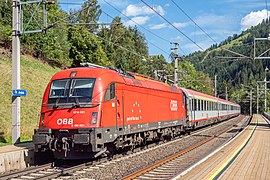 An ÖBB EuroSprinter on the Brenner railway.
 -
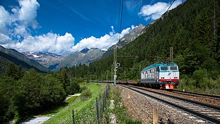 An FS Class E.652 with a train on the Brenner railway.
 -
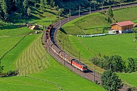 An ÖBB Class 1044 with a train on the Brenner railway.
 -
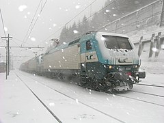 FS Class E.412 on the Brenner railway.


_by_Sankt_Jodok_-_Tirol_-_AT_(48985188642).jpg)

References
[edit]Notes
[edit]Footnotes
[edit]- ^ Railway Atlas 2017, pp. 3, 8, 9, 23, 24, 136, 137.
- ^ "Rete FS in esercizio (FS operational network)" (PDF) (in Italian). Ferrovie dello Stato. Archived from the original (PDF) on 22 July 2011. Retrieved 4 February 2010.
- ^ Kalla-Bishop 1971, p. 21
- ^ Kalla-Bishop 1971, p. 41
- ^ Kalla-Bishop 1971, p. 52
- ^ Kalla-Bishop 1971, p. 103
- ^ "The Brenner Base Tunnel". Amministrazione trasparente Galleria di Base del Brennero - Brenner Basistunnel BBT SE. Retrieved 1 January 2016.
Sources
[edit]- Facchinelli, L. (1995), La ferrovia Verona–Brennero. Storia della linea e delle stazioni nel territorio (the Verona–Brennero railway, history of the lines and stations in the area) (in Italian), Bolzano: Athesia
- Kalla-Bishop, P. M. (1971), Italian Railways, Newton Abbott, Devon, England: David & Charles, ISBN 0-7153-5168-0
- Mori, Edoardo, La ferrovia da Verona a Monaco di Baviera (The railway from Verona to Munich) (in Italian), Calosci Editore
- Tuzza, Alessandro, ed. (1927). "Prospetto cronologico dei tratti di ferrovia aperti all'esercizio dal 1839 al 31 dicembre 1926" (in Italian). Ufficio Centrale di Statistica delle Ferrovie dello Stato/Trenidicarta.it. Retrieved 6 September 2020.
- Atlante ferroviario d'Italia e Slovenia [Railway atlas of Italy and Slovenia]. Schweers + Wall. 2010. ISBN 978-3-89494-129-1.}
See also
[edit]
46°18′26″N 11°14′51″E / 46.30722°N 11.24750°E
| International | |
|---|---|
| National | |