
Arrowhead Trail (auto trail): Difference between revisions
Rescuing 1 sources and tagging 2 as dead. #IABot (v1.4) |
GreenC bot (talk | contribs) Move 1 url. Wayback Medic 2.5 per WP:URLREQ#articles.latimes.com |
||
| (46 intermediate revisions by 29 users not shown) | |||
| Line 1: | Line 1: | ||
{{short description|Former auto trail in California, Nevada, and Utah in the Western United States}} |
|||
{{use mdy dates|date=March 2022}} |
|||
{{Infobox road |
{{Infobox road |
||
|country=USA |
| country = USA |
||
| type = Trail |
|||
| ⚫ | |||
| ⚫ | |||
|header_type=hist |
|||
| ⚫ | |||
|marker_image=[[File:Arrowhead Trails Association.svg|100px]] |
|||
| length_ref = <ref name="Motor West 1917">{{Cite book |url=https://books.google.com/books?id=PqYAAAAAMAAJ&pg=RA6-PA9 |title=Arrowhead Trail from Los Angeles to Salt Lake |date=1917-09-15 |work=Motor West |publisher=Motor West Company |volume=27 |pages=9 |access-date=2012-02-18 |issue=11}}</ref> |
|||
| ⚫ | |||
| ⚫ | |||
|map=Arrowhead_Trail_Map.png |
|||
| ⚫ | |||
| ⚫ | |||
| ⚫ | |||
|length_round=1 |
|||
| ⚫ | |||
|length_ref=<ref name="Motor West 1917">{{cite journal |last1= |first1= |date=15 September 1917 |title=Arrowhead Trail from Los Angeles to Salt Lake |journal=Motor West |volume=27 |issue=11 |pages=9 |publisher=Motor West Company |doi= |url=https://books.google.com/books?id=PqYAAAAAMAAJ&pg=RA6-PA9#v=onepage&q&f=false |accessdate=18 February 2012 }}</ref> |
|||
| ⚫ | |||
| ⚫ | |||
| ⚫ | |||
| ⚫ | |||
| ⚫ | |||
| ⚫ | |||
| ⚫ | |||
| ⚫ | |||
| ⚫ | |||
| ⚫ | |||
| ⚫ | |||
| ⚫ | |||
|system='''[[Auto trail|Auto Trails]]''' |
|||
| ⚫ | |||
| designation1 = Nevada Historical Marker |
| designation1 = Nevada Historical Marker |
||
| designation1_offname = Arrowhead Trail (1914-1924) |
| designation1_offname = Arrowhead Trail (1914-1924) |
||
| designation1_number = 168<ref name= |
| designation1_number = 168<ref name=marker168/> |
||
| designation2 = Nevada Historical Marker |
| designation2 = Nevada Historical Marker |
||
| designation2_offname = Arrowhead Trail - Henderson |
| designation2_offname = Arrowhead Trail - Henderson |
||
| designation2_number = 197<ref name= |
| designation2_number = 197<ref name=marker197/> |
||
}} |
}} |
||
}} |
}} |
||
The '''Arrowhead Trail''' or '''Arrowhead Highway''' was the first all-weather road |
The '''Arrowhead Trail''' or '''Arrowhead Highway''' was the first all-weather road in the [[Western United States]] that connected [[Los Angeles]], [[California]] with [[Salt Lake City]], [[Utah]] by way of [[Las Vegas]], [[Nevada]]. Built primarily during the [[auto trail]]s period of the 1910s, prior to the establishment of the [[United States Numbered Highway System]], the road was replaced in 1926 by [[U.S. Route 91]] (US 91) and subsequently [[Interstate 15]] (I-15).<ref name="1925 list" /><ref name="1926 map" /> Small portions of the route in California, Nevada ([[Las Vegas Boulevard]]) and Utah are sometimes still referred to by the name, or as '''Arrow Highway'''. |
||
== |
==History== |
||
| ⚫ | Starting in 1915, auto racing champion [[Charles Bigelow (racing driver)|Charles H. Bigelow]] drove the entire route many times to generate publicity for the road.<ref name="marker168">{{Cite web |title=Arrowhead Trail (1914-1924) |url=http://shpo.nv.gov/nevadas-historical-markers/historical-markers/arrowhead-trail |access-date=2020-04-03 |publisher=Nevada State Historic Preservation Office}} State Historical Marker No. 168.</ref> |
||
| ⚫ | |||
| ⚫ | The Arrowhead Trail initially took a longer route via present [[U.S. Route 95]] and former [[U.S. Route 66 in California|U.S. Route 66]] between Las Vegas and [[Needles, California|Needles]], California, as the more direct [[Old Spanish Trail (trade route)|Old Spanish Trail]] was in very poor condition.<ref>{{Cite book |url=https://books.google.com/books?id=Mt0NAAAAYAAJ |title=Official Automobile Blue Book |work=[[Automobile Blue Book]] |year=1917 |volume=8 |page=501}}</ref><ref>{{Cite web |title=Touring Atlas of the United States |url=http://usautotrails.com/CaliforniaPage/ClasonsCaliforniaPage/image1.html |website=[[Clason Map Company]] |access-date=February 9, 2009 |archive-date=September 16, 2020 |archive-url=https://web.archive.org/web/20200916015429/http://usautotrails.com/CaliforniaPage/ClasonsCaliforniaPage/image1.html |url-status=dead }}, 1925</ref> The "[[Silver Lake, San Bernardino County, California|Silver Lake]] cutoff", which would save about 90 miles (145 km),<ref>{{Cite news |date=1923-12-21 |title=Auto Club News |work=[[Van Nuys News]]}}</ref> was proposed by 1920,<ref>{{Cite news |date=1920-12-26 |title=Brice Canyon, Zion Canyon National Park, Utah |page=VIII1 |work=[[Los Angeles Times]]}}</ref> and completed in 1925 as an [[oiled road]] by [[San Bernardino County, CA|San Bernardino County]].<!--did the Arrowhead Trail move to the Old Spanish Trail in 1924? did the 1925 route bypass Silver Lake?--><ref>{{Cite web |last=Nystrom |first=Eric Charles |date=March 2003 |title=From Neglected Space To Protected Place: An Administrative History of Mojave National Preserve |url=http://www.nps.gov/archive/moja/adminhist/adhi2a.htm |publisher=[[National Park Service]]}}</ref><ref>{{Cite news |date=1925-10-25 |title=State Takes Over Cut-off to Nevada Line |page=G12 |work=[[Los Angeles Times]]}}</ref> |
||
| ⚫ | Starting in 1915, [[Charles Bigelow (racing driver)|Charles H. Bigelow]] drove the entire route many times to generate publicity for the road.<ref>{{ |
||
| ⚫ | Both the U.S. [[Bureau of Public Roads]] and the State of Nevada urged the inclusion of the cutoff route into each state's highway systems, the former as part of the [[federal aid]] highway connecting Salt Lake City and Los Angeles,<ref name="1925report">{{Cite book |title=Report of a Study of the State Highway System of California |work=California Highway Advisory Committee |publisher=California State Printing Office |year=1925 |editor-last=Arthur Hastings Breed |page=97}}</ref> and the [[California State Legislature]] did that in 1925,<ref>{{cite CAstat|year=1925|ch=369|p=670}}</ref> with it becoming an extension of [[Legislative Route 31 (California pre-1964)|Route 31]]. (Across the state line in Nevada, [[Nevada State Route 6 (1919-1976)|State Route 6]] continued through Las Vegas to [[Arizona]].) The initial plan for the [[U.S. Highway system]] simply stated that Route No. 91 would run from Las Vegas "to an intersection with Route No. 60" (which became US 66 in 1926),<ref name="1925 list">{{Cite book |last=Joint Board on Interstate Highways |url= https://en.wikisource.org/wiki/Report_of_Joint_Board_on_Interstate_Highways_October_30,_1925 |title=Report of Joint Board on Interstate Highways, October 30, 1925, Approved by the Secretary of Agriculture, November 18, 1925 |publisher=[[United States Department of Agriculture]] |year=1925 |location=Washington, DC |type=Report |id={{OCLC|733875457|55123355|71026428}} |access-date=2017-11-14 |via=[[Wikisource]]}}</ref> but in 1926 the cutoff was chosen, ending at US 66 at [[Daggett, California|Daggett]], just east of Barstow.<ref name="1926 map">{{Cite map |work=[[Bureau of Public Roads]] |series=[[American Association of State Highway Officials]] |date= 1926-11-11 |title=United States System of Highways Adopted for Uniform Marking by the American Association of State Highway Officials |url=https://commons.wikimedia.org/wiki/File:United_States_System_of_Highways_Adopted_for_Uniform_Marking_by_the_American_Association_of_State_Highway_Officials.jpg |scale=1:7,000,000 |location=Washington, DC |publisher=[[United States Geological Survey]] |oclc=32889555 |access-date= 2013-11-07 |via=[[Wikimedia Commons]] |name-list-style=amp}}</ref><!--looks like they erroneously drew it along the railroad alignment--><ref name="1927 log">{{Cite book |title=United States Numbered Highways |date=April 1927 |work=[[American Highways]] |publisher=[[American Association of State Highway Officials]]}}</ref> |
||
| ⚫ | The Arrowhead Trail initially took a longer route via present [[ |
||
| ⚫ | The original routing south from Las Vegas to Needles later became part of US 95 in 1940. The new "cutoff route" was added to the federal-aid secondary system in 1926,<ref>{{cite news | work = [[Los Angeles Times]] | title = Silver Lake Cut-off to Get Federal Aid | date = 1926-02-14| page = G5}}</ref> which helped pay for a mid-1930s widening and paving, including some realignments (parts of the old road are now known as Arrowhead Trail).<!--more details? Mountain Pass to Nevada was all bypassed, as were other significant portions--> The new routing generally followed the present [[Interstate 15 in California|I-15]], except through [[Baker, California|Baker]] (where it used Baker Boulevard) and into Barstow (where it followed former [[California State Route 58|SR 58]] to First Avenue, ending at Main Street, which carried US 66).<ref>{{Cite map |url=http://www.lib.berkeley.edu/EART/CA/CA_125k/ |archive-url=https://web.archive.org/web/20040823215543/http://www.lib.berkeley.edu/EART/CA/CA_125k/ |archive-date=2004-08-23 |title=Barstow |year=1934 |scale=1:125000 |work=[[United States Geological Survey]] }}, {{cite map |url= http://cricket.csuchico.edu/spcfotos/maps/topo_search.html |title= Avawatz Mountains |year= 1933 |scale= 1:125000 |work= |access-date= November 29, 2021 |archive-date= July 7, 2012 |archive-url= https://archive.today/20120707204303/http://cricket.csuchico.edu/spcfotos/maps/topo_search.html |url-status= bot: unknown }}; and {{cite map |url=http://www.lib.berkeley.edu/EART/CA/CA_125k |archive-url=https://web.archive.org/web/20040823215543/http://www.lib.berkeley.edu/EART/CA/CA_125k |archive-date=2004-08-23 |title=Ivanpah |year=1942 |scale=1:250000 |work= }}</ref>{{fact|date=March 2022}} It entered San Bernardino on Cajon Boulevard, then followed the route of Arrow Highway between San Bernardino and Los Angeles. This route is still called Arrow Route or Arrow Highway through parts of Rancho Cucamonga, Upland, Montclair and Claremont as well as other cities between Irwindale and San Bernardino.<ref>{{Cite news|newspaper=LA Times |title=Traveling a Good Road in a Fine Car--Life Doesn't Get Better Than This |url=https://www.latimes.com/archives/la-xpm-2000-feb-16-hw-64676-story.html |url-status=live |archive-url=https://web.archive.org/web/20150909215233/http://articles.latimes.com/2000/feb/16/news/hw-64676 |archive-date=September 9, 2015 | date= 2000-02-16 | first = Steve | last = Tice}}</ref> |
||
| ⚫ | Both the U.S. [[Bureau of Public Roads]] and the |
||
The [[Clark County, Nevada|Clark County]], Nevada sections of the trail are marked by [[Nevada Historical Marker]]s 168 and 197.<ref name="marker168" /><ref name="marker197">{{Cite web |title=Arrowhead Trail - Henderson |url=http://shpo.nv.gov/nevadas-historical-markers/historical-markers/arrowhead-trail-henderson |access-date=2020-04-03 |publisher=Nevada State Historic Preservation Office |quote=State Historical Marker No. 197}}</ref> |
|||
| ⚫ | |||
A monument to the Arrowhead Trail lies across from the north end of the [[Terrible's Hotel & Casino]] [formerly the Gold Strike Hotel and Gambling Hall] property's entrance in [[Jean, Nevada]]. It is from here that Las Vegas Boulevard begins and proceeds north to the Las Vegas Strip. |
|||
| ⚫ | The original routing south from Las Vegas to Needles later became part of US 95 in 1940. The new "cutoff route" was added to the federal-aid secondary system in 1926,<ref>[[Los Angeles Times]] |
||
==Gallery== |
|||
The [[Clark County, Nevada]] sections of the trail are marked by [[Nevada Historical Marker]]s 168 and 197.<ref name=markers>{{cite web|title=Nevada Historical Markers |url=http://nvshpo.org/home-topmenu-17-17/historical-markers.html |publisher=Nevada State Historic Preservation Office |accessdate=29 September 2013 |deadurl=yes |archiveurl=https://web.archive.org/web/20130204045518/http://nvshpo.org/home-topmenu-17-17/historical-markers.html |archivedate=4 February 2013 }}</ref> |
|||
<gallery> |
|||
| ⚫ | |||
| ⚫ | File:West end of the Vermillion Cliffs, looking northwest. U.S. Highway ^91 (Arrowhead Trail), main road from Salt Lake... - NARA - 520405.jpg| A 1929 photo of the Arrowhead Trail, now Old Hwy 91, about {{convert|5|mi|km}} west of [[Santa Clara, Utah|Santa Clara]], [[Utah]]. [[File:Close up of Plaque on the Arrowhead Trail Highway Marker.jpg|thumb|Arrowhead Trail Highway Marker in Jean, Nevada.]] |
||
</gallery> |
|||
== |
==Current route names== |
||
* [[California State Route 91]] |
* [[California State Route 91]] |
||
* [[Interstate 15]] |
* [[Interstate 15]] |
||
| Line 50: | Line 53: | ||
* [[Las Vegas Boulevard]] |
* [[Las Vegas Boulevard]] |
||
== |
==See also== |
||
{{stack|{{portal|U.S. Roads|California|Nevada|Utah}}}} |
|||
{{Reflist|2}} |
|||
* [[Auto trail#List of auto trails|List of auto trails]] |
|||
{{clear}} |
|||
==References== |
|||
| ⚫ | |||
{{reflist|22em}} |
|||
| ⚫ | |||
{{commons category|Arrowhead Trail (auto trail)}} |
{{commons category|Arrowhead Trail (auto trail)}} |
||
* [http://www.americanroads.us/articles/Motor_West_1917_9_15_9.html Arrowhead Trail article on americanroads.com] |
* [http://www.americanroads.us/articles/Motor_West_1917_9_15_9.html Arrowhead Trail article on americanroads.com] |
||
{{Portal-inline|U.S. Roads}} |
|||
{{authority control}} |
|||
{{Portal-inline|California}} |
|||
{{Portal-inline|Nevada}} |
|||
{{Portal-inline|Utah}} |
|||
[[Category:Auto trails in the United States]] |
[[Category:Auto trails in the United States]] |
||
| Line 66: | Line 73: | ||
[[Category:Historic trails and roads in Nevada]] |
[[Category:Historic trails and roads in Nevada]] |
||
[[Category:Historic trails and roads in Utah]] |
[[Category:Historic trails and roads in Utah]] |
||
[[Category:Nevada historical markers]] |
|||
[[Category:U.S. Route 91]] |
[[Category:U.S. Route 91]] |
||
Latest revision as of 22:44, 14 August 2024
 Arrowhead Trail | |
|---|---|
 | |
| Route information | |
| Length | 853.4 mi[1] (1,373.4 km) Length of the original route along the National Old Trails Road and north through Searchlight, NV. |
| History | Arrowhead Trails Association formed in 1916, and incorporated in California on December 7, 1916. |
| Major junctions | |
| South end | Los Angeles, CA |
| North end | Salt Lake City, UT |
| Location | |
| Country | United States |
| States | California, Nevada, Arizona, Utah |
| Highway system | |
| Official name | Arrowhead Trail (1914-1924) |
| Reference no. | 168[2] |
| Official name | Arrowhead Trail - Henderson |
| Reference no. | 197[3] |
The Arrowhead Trail or Arrowhead Highway was the first all-weather road in the Western United States that connected Los Angeles, California with Salt Lake City, Utah by way of Las Vegas, Nevada. Built primarily during the auto trails period of the 1910s, prior to the establishment of the United States Numbered Highway System, the road was replaced in 1926 by U.S. Route 91 (US 91) and subsequently Interstate 15 (I-15).[4][5] Small portions of the route in California, Nevada (Las Vegas Boulevard) and Utah are sometimes still referred to by the name, or as Arrow Highway.
History
[edit]Starting in 1915, auto racing champion Charles H. Bigelow drove the entire route many times to generate publicity for the road.[2]
The Arrowhead Trail initially took a longer route via present U.S. Route 95 and former U.S. Route 66 between Las Vegas and Needles, California, as the more direct Old Spanish Trail was in very poor condition.[6][7] The "Silver Lake cutoff", which would save about 90 miles (145 km),[8] was proposed by 1920,[9] and completed in 1925 as an oiled road by San Bernardino County.[10][11]
Both the U.S. Bureau of Public Roads and the State of Nevada urged the inclusion of the cutoff route into each state's highway systems, the former as part of the federal aid highway connecting Salt Lake City and Los Angeles,[12] and the California State Legislature did that in 1925,[13] with it becoming an extension of Route 31. (Across the state line in Nevada, State Route 6 continued through Las Vegas to Arizona.) The initial plan for the U.S. Highway system simply stated that Route No. 91 would run from Las Vegas "to an intersection with Route No. 60" (which became US 66 in 1926),[4] but in 1926 the cutoff was chosen, ending at US 66 at Daggett, just east of Barstow.[5][14]
The original routing south from Las Vegas to Needles later became part of US 95 in 1940. The new "cutoff route" was added to the federal-aid secondary system in 1926,[15] which helped pay for a mid-1930s widening and paving, including some realignments (parts of the old road are now known as Arrowhead Trail). The new routing generally followed the present I-15, except through Baker (where it used Baker Boulevard) and into Barstow (where it followed former SR 58 to First Avenue, ending at Main Street, which carried US 66).[16][citation needed] It entered San Bernardino on Cajon Boulevard, then followed the route of Arrow Highway between San Bernardino and Los Angeles. This route is still called Arrow Route or Arrow Highway through parts of Rancho Cucamonga, Upland, Montclair and Claremont as well as other cities between Irwindale and San Bernardino.[17]
The Clark County, Nevada sections of the trail are marked by Nevada Historical Markers 168 and 197.[2][3]
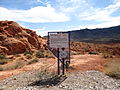
A monument to the Arrowhead Trail lies across from the north end of the Terrible's Hotel & Casino [formerly the Gold Strike Hotel and Gambling Hall] property's entrance in Jean, Nevada. It is from here that Las Vegas Boulevard begins and proceeds north to the Las Vegas Strip.
Gallery
[edit]-
-
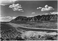 A 1929 photo of the Arrowhead Trail, now Old Hwy 91, about 5 miles (8.0 km) west of Santa Clara, Utah.
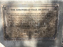
Arrowhead Trail Highway Marker in Jean, Nevada.
,_Nevada_Historical_Marker_No._168.jpg)
,_main_road_from_Salt_Lake..._-_NARA_-_520405.jpg)

Current route names
[edit]See also
[edit]References
[edit]- ^ Arrowhead Trail from Los Angeles to Salt Lake. Vol. 27. Motor West Company. September 15, 1917. p. 9. Retrieved February 18, 2012.
{{cite book}}:|work=ignored (help) - ^ a b c "Arrowhead Trail (1914-1924)". Nevada State Historic Preservation Office. Retrieved April 3, 2020. State Historical Marker No. 168.
- ^ a b "Arrowhead Trail - Henderson". Nevada State Historic Preservation Office. Retrieved April 3, 2020.
State Historical Marker No. 197
- ^ a b Joint Board on Interstate Highways (1925). Report of Joint Board on Interstate Highways, October 30, 1925, Approved by the Secretary of Agriculture, November 18, 1925 (Report). Washington, DC: United States Department of Agriculture. OCLC 733875457, 55123355, 71026428. Retrieved November 14, 2017 – via Wikisource.
- ^ a b "United States System of Highways Adopted for Uniform Marking by the American Association of State Highway Officials" (Map). Bureau of Public Roads. 1:7,000,000. American Association of State Highway Officials. Washington, DC: United States Geological Survey. November 11, 1926. OCLC 32889555. Retrieved November 7, 2013 – via Wikimedia Commons.
- ^ Official Automobile Blue Book. Vol. 8. 1917. p. 501.
{{cite book}}:|work=ignored (help) - ^ "Touring Atlas of the United States". Clason Map Company. Archived from the original on September 16, 2020. Retrieved February 9, 2009., 1925
- ^ "Auto Club News". Van Nuys News. December 21, 1923.
- ^ "Brice Canyon, Zion Canyon National Park, Utah". Los Angeles Times. December 26, 1920. p. VIII1.
- ^ Nystrom, Eric Charles (March 2003). "From Neglected Space To Protected Place: An Administrative History of Mojave National Preserve". National Park Service.
- ^ "State Takes Over Cut-off to Nevada Line". Los Angeles Times. October 25, 1925. p. G12.
- ^ Arthur Hastings Breed, ed. (1925). Report of a Study of the State Highway System of California. California State Printing Office. p. 97.
{{cite book}}:|work=ignored (help) - ^ California State Assembly. "An act authorizing and directing the California highway commission to acquire necessary rights of way, and to construct and maintain a highway, which is hereby declared to be a state highway, extending from Barstow...to a point...on the boundary line between the state of California and the state of Nevada...which said highway is commonly known and referred to as the Arrowhead trail". Forty-sixth Session of the Legislature. Statutes of California. State of California. Ch. 369 p. 670.
- ^ United States Numbered Highways. American Association of State Highway Officials. April 1927.
{{cite book}}:|work=ignored (help) - ^ "Silver Lake Cut-off to Get Federal Aid". Los Angeles Times. February 14, 1926. p. G5.
- ^ "Barstow" (Map). United States Geological Survey. 1:125000. 1934. Archived from the original on August 23, 2004., Avawatz Mountains (Map). 1:125000. 1933. Archived from the original on July 7, 2012. Retrieved November 29, 2021.
{{cite map}}: CS1 maint: bot: original URL status unknown (link); and Ivanpah (Map). 1:250000. 1942. Archived from the original on August 23, 2004. - ^ Tice, Steve (February 16, 2000). "Traveling a Good Road in a Fine Car--Life Doesn't Get Better Than This". LA Times. Archived from the original on September 9, 2015.
External links
[edit]